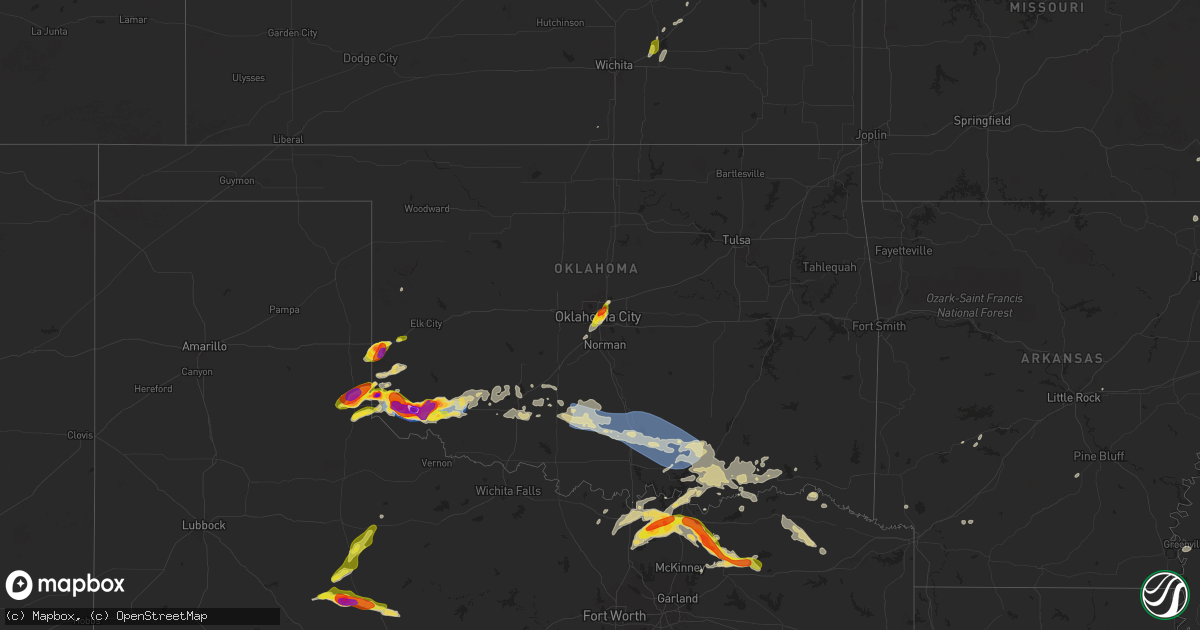
Hail Map on May 23, 2024
Get this storm
May 23 map
$229
one time, instant access
Download today. No call, no setup
Keep the $229
Bought the map and want the full workflow? Apply the entire $229 to a subscription within 7 days. None of it is wasted.
Every map, not just this one
This buys you this map. Subscription and you get every map we run, in the markets you choose from a few cities to whole states to nationwide. Plus real-time alerts the moment a storm fires.
Contact data
Name, contact info, occupancy, even credit band for addresses in the footprint. You go from where it hit to who to call.
Become the source they trust
Unlimited branding weather history reports on demand. You already have the documented answer ready for the property owner, and you are the one who showed up with it.
Property data and RoofTrace estimates
Pull up any address you have got, its value and the exact code rules for that jurisdiction, straight from One Click Code. Then RoofTrace estimates the squares, pitch, and roof value, priced the way you price.
States Impacted by Hail Map on May 23, 2024
Storm reports
Virginia
| Date | Description |
|---|---|
| 05/23/20245:24 PM CDT | Multiple trees down onto roadway near lovettsville... Va. |
| 05/23/20243:48 PM CDT | Ping pong ball sized hail in strasburg... Va. |
| 05/23/20243:48 PM CDT | Ping pong sized hail in strasburg... Va. |
| 05/23/20243:22 PM CDT | Power lines downed on cooksburg road near its intersection with chippewa lane. Time estimated from radar. |
| 05/23/20243:02 PM CDT | Tree down across martin drive. |
| 05/23/20242:48 PM CDT | Tree down on multiple power lines on plantation road. Time estimated from radar. |
| 05/23/20242:45 PM CDT | Tree down along spruce street. Time estimated from radar. |
| 05/23/20242:36 PM CDT | Several trees down around the city of martinsville... Particularly in the collinsville area. Time estimated from radar. |
| 05/23/20242:34 PM CDT | Tree down across melrose drive near sunbeam road. Time estimated from radar. |
| 05/23/20242:30 PM CDT | Tree down blocking one lane of tenth street near pine street. Time estimated from radar. |
| 05/23/20242:28 PM CDT | Tree down blocking dillons fork road near william f stone parkway. |
Mississippi
| Date | Description |
|---|---|
| 05/23/202411:40 AM CDT | A large tree limb fell on mobile home and damaged a propane tank. |
Georgia
| Date | Description |
|---|---|
| 05/23/20243:50 PM CDT | Quarter sized hail reported near the intersection of i-75 and hwy 53. |
| 05/23/20243:28 PM CDT | Report from mping: half dollar |
Connecticut
| Date | Description |
|---|---|
| 05/23/202410:35 AM CDT | Four utility poles were blown down and a 5th was snapped at the top on eknonk hill rd in plainfield. There were also large branches down. |
| 05/23/202410:33 AM CDT | Large tree and wires down. |
| 05/23/202410:30 AM CDT | Trees down near the intersection of scotland road and lawler lane. |
| 05/23/202410:25 AM CDT | Trees and wires down on roode road... Road impassable. |
| 05/23/202410:25 AM CDT | Multiple trees and wires down on bishop crossing road. |
| 05/23/202410:25 AM CDT | Trees down on wires on hell hollow road south of stone hill reservoir. |
| 05/23/202410:25 AM CDT | Tree and wires down on pauline place. |
| 05/23/202410:25 AM CDT | Large tree and wires down in area of edmond road. |
| 05/23/202410:22 AM CDT | Estimated 1 inch diameter hail along interstate 395 near taylor hill rd. |
| 05/23/20247:29 AM CDT | Several trees down. One large tree down on clapboard ridge road. |
Maryland
| Date | Description |
|---|---|
| 05/23/20245:41 PM CDT | Numerous trees down in and around adamstown... Md. |
| 05/23/20245:36 PM CDT | Uprooted tree and siding ripped off house near adamstown... Md. |
| 05/23/20245:27 PM CDT | A local report indicates 1.00 inch wind near 1 ENE Point Of Rocks |
North Dakota
| Date | Description |
|---|---|
| 05/23/20246:50 PM CDT | Hail to the size of quarters began at 650 pm and lasted 5 minutes until 655 pm. |
| 05/23/20246:42 PM CDT | Hail began at 642 pm and lasted 25 minutes until 707 pm. Lots of dime to nickel sized hail... With some hailstones up to the size of quarters. |
| 05/23/20246:38 PM CDT | Spotter reported approximately ping pong-sized hail for around 3 minutes. |
| 05/23/20246:30 PM CDT | Strong winds of 50 to 60 mph began at 630 pm and lasted 12 minutes to 642 pm. Pea to dime sized hail also fell with the strong winds. |
| 05/23/20246:28 PM CDT | Storm spotter reported a tornado that lasted almost a minute. The spotter sent us the video of the tornado briefly touching down in a field just south of his house. |
| 05/23/20246:08 PM CDT | Hail... Dime to quarter sized began at 608 pm and lasted 2 minutes until 610 pm. |
| 05/23/20246:05 PM CDT | Public report relayed by broadcast media. Hail size estimated. |
| 05/23/20246:00 PM CDT | 3-5 inch tree limbs blown down. |
| 05/23/20245:27 PM CDT | Hail up to the size of quarters began at 527 pm and lasted until 545 pm. |
| 05/23/20245:23 PM CDT | Just a few large hailstones fell... Up to the size of golfballs. |
| 05/23/20244:15 PM CDT | Hail began at 415 pm and lasted until 420 pm. Hail size ranged from dime to half dollar. |
| 05/23/20244:05 PM CDT | Relayed via social media. |
| 05/22/20247:11 PM CDT | Mesonet station tt584 12 e mott. |
New Jersey
| Date | Description |
|---|---|
| 05/23/20249:00 AM CDT | Downed tree on hoffman avenue between cypress street and beech place. |
| 05/23/20248:58 AM CDT | Mesonet station fw2280 jersey city. |
| 05/23/20248:50 AM CDT | Wires down on main street off sr-4 and north of grand avenue. |
| 05/23/20248:30 AM CDT | Smull avenue closed from ward place to hatfield street due to downed power lines. |
| 05/23/20248:30 AM CDT | Smull avenue closed from ward place to hatfield street due to downed power lin based on radar. |
| 05/23/20248:20 AM CDT | Tree down on mt. Hope ro |
| 05/23/20248:20 AM CDT | Tree down on mt. Hope road in front of the mt. Hope fire house. The tree brought down power lines into the roadway. Time estimated from radar. |
| 05/23/20247:56 AM CDT | Report from mping: 1-inch tree limbs broken. |
| 05/23/20247:54 AM CDT | Numerous large tree limbs down in alexandria township... Including along bloomook road. |
| 05/23/20247:54 AM CDT | Numerous large tree limbs down in alexandria township... Including along bloomsbury road between swinesburg and bloomsbury. Time estimated from radar. |
| 05/23/20247:52 AM CDT | Several very large tree limbs down. Time estimated from radar. |
| 05/23/20247:52 AM CDT | Measured 62 mph wind gust with a thunderstorm via a home weather station. |
| 05/23/20247:45 AM CDT | Trees down... Some 6 inches in diameter and split... On roseberry street in phillipsburg. Time estimated from radar. |
Oklahoma
| Date | Description |
|---|---|
| 05/23/20246:59 PM CDT | Report from mping: quarter |
| 05/23/20246:31 PM CDT | Report from mping: quarter |
| 05/23/20246:22 PM CDT | Report from mping |
| 05/23/20246:22 PM CDT | Report from mping: half dollar |
| 05/23/20246:20 PM CDT | Report from mping: golf ball |
| 05/23/20246:18 PM CDT | A local report indicates 1.50 inch wind near 1 SSE Gould |
| 05/23/20246:15 PM CDT | A local report indicates 66 MPH wind near 3 W Gould |
| 05/23/20245:58 PM CDT | A local report indicates 2.50 inch wind near 1 NNE Hollis |
| 05/23/20245:37 PM CDT | Report from mping: golf ball |
| 05/23/20245:33 PM CDT | Report from mping: golf ball |
| 05/23/20245:32 PM CDT | Report from mping: quarter |
| 05/23/20245:28 PM CDT | Report from mping: quarter |
| 05/23/20245:26 PM CDT | Report from mping: quarter |
| 05/23/20245:17 PM CDT | Report from mping: golf ball |
| 05/23/20245:05 PM CDT | Report from mping: quarter |
| 05/23/20245:03 PM CDT | Report from mping: hen egg |
| 05/23/20244:59 PM CDT | Report from mping: quarter |
| 05/23/20244:54 PM CDT | Report from mping: golf ball |
| 05/23/20244:47 PM CDT | Report from mping: quarter |
| 05/23/20244:44 PM CDT | Report from mping: golf ball |
| 05/23/20244:43 PM CDT | Report from mping: quarter |
| 05/23/20244:40 PM CDT | A local report indicates 1.00 inch wind near 2 NNE Oklahoma City |
| 05/23/20244:36 PM CDT | Report from mping: quarter |
| 05/23/20244:21 PM CDT | Report from mping: quarter |
| 05/23/20242:34 AM CDT | A nws survey determined straight-line wind damage in the pleasant hill and union grove communities just south of the town of haworth. Damage consisted of mostly of down |
| 05/23/202412:05 AM CDT | A local report indicates 73 MPH wind near 7 NW Velma |
| 05/22/202411:24 PM CDT | Outbuilding near the town water tower lost its roof. |
| 05/22/202410:19 PM CDT | Report from mping: quarter |
| 05/22/20248:40 PM CDT | A local report indicates 2.75 inch wind near Duke |
| 05/22/20248:37 PM CDT | A local report indicates 1.75 inch wind near Duke |
| 05/22/20248:37 PM CDT | Report from mping: quarter |
| 05/22/20248:35 PM CDT | A local report indicates 67 MPH wind near 3 S Altus |
| 05/22/20248:30 PM CDT | A local report indicates 60 MPH wind near 3 S Altus |
| 05/22/20248:25 PM CDT | A local report indicates 68 MPH wind near 3 S Altus |
| 05/22/20248:25 PM CDT | A local report indicates 61 MPH wind near Altus Air Force Base |
| 05/22/20248:25 PM CDT | Report from mping: 3-inch tree limbs broken; power poles broken. |
| 05/22/20248:18 PM CDT | Report from mping: quarter |
| 05/22/20248:18 PM CDT | Report from mping: half dollar |
| 05/22/20248:10 PM CDT | Report from mping: hen egg |
| 05/22/20248:02 PM CDT | Report from mping: golf ball |
| 05/22/20247:59 PM CDT | Report from mping: half dollar |
| 05/22/20247:58 PM CDT | Report from mping: golf ball |
| 05/22/20247:43 PM CDT | Report from mping: hen egg |
| 05/22/20247:25 PM CDT | A local report indicates 3.50 inch wind near 3 E Duke |
| 05/22/20247:04 PM CDT | A local report indicates a tornado near 6 N Eldorado |
Pennsylvania
| Date | Description |
|---|---|
| 05/23/20247:30 AM CDT | Report from mping: 1-inch tree limbs broken. Time estimated from radar. |
| 05/23/20247:30 AM CDT | Downed trees and power lines along stefko boulevard in bethlehem. Time estimated from radar. |
| 05/23/20247:30 AM CDT | Multiple trees and large tree limbs down along wagner drive in bethlehem township. Time estimated from radar. |
| 05/23/20247:23 AM CDT | Some trees down on magellan drive in walnutport. Time estimated from radar. |
| 05/23/20247:23 AM CDT | Several large trees snapped at the base in the childrens health care parking lot on pond road in allentown. Three cars trapped under one of the downed trees. No injurie |
| 05/23/20247:22 AM CDT | Fire department dispatched to walbert avenue and columbia street for trees and wires down. Time estimated from radar. |
| 05/23/20247:17 AM CDT | Large tree snapped and fell onto power lines. Time estimated from radar. |
| 05/22/20248:00 PM CDT | Tree down on a vehicle in springfield twp. No injuries reported. |
| 05/22/20248:00 PM CDT | Corrects previous tstm wnd dmg report from 1 ne loganville. Tree and wires down on an occupied vehicle near the intersection of dunkard valley road and loucks road in s |
South Dakota
| Date | Description |
|---|---|
| 05/23/20246:19 PM CDT | Time estimated from radar. |
| 05/23/20246:11 PM CDT | Mesonet station 158 miranda |
| 05/23/20246:05 PM CDT | A local report indicates 61 MPH wind near 1 S Miller |
| 05/23/20245:50 PM CDT | A local report indicates 1.00 inch wind near 5 NNW Joe Creek Rec Are |
| 05/23/20245:39 PM CDT | A local report indicates 1.00 inch wind near 2 NNW Aberdeen |
| 05/23/20245:37 PM CDT | A local report indicates 1.00 inch wind near 2 WSW Aberdeen |
| 05/23/20245:11 PM CDT | A local report indicates 1.00 inch wind near 5 NNW Joe Creek Rec Are |
| 05/23/20244:45 PM CDT | Corrects previous hail report from 8 wnw polo. Radar estimated time. |
| 05/23/20244:40 PM CDT | Radar estimated time. |
| 05/23/20244:31 PM CDT | Quarter to golf ball size hail. |
| 05/23/20244:30 PM CDT | Radar estimated time. |
| 05/23/20244:30 PM CDT | Time estimated. |
| 05/22/202410:11 PM CDT | Mesonet station 313 5se selby |
| 05/22/20249:55 PM CDT | Mesonet station gots2 groton 9 nne |
| 05/22/20248:08 PM CDT | A local report indicates 1.00 inch wind near 9 SW Hoven |
| 05/22/20247:30 PM CDT | A local report indicates 1.00 inch wind near 1 NNW Agar |
| 05/22/20247:00 PM CDT | Relayed by em. |
Minnesota
| Date | Description |
|---|---|
| 05/23/20244:55 AM CDT | Baseball field dugout destroyed... Large tree split... Large branches down. Pictures relayed via slack. Time estimated by radar. |
| 05/23/20244:55 AM CDT | Baseball field dugout destroyed... Large tree split... Large branches down. Pictures relayed via slack. Time estimated by radar. |
| 05/23/20243:14 AM CDT | Spotter reported a few quarter sized hail stones. |
Kansas
| Date | Description |
|---|---|
| 05/22/202410:54 PM CDT | Estimat |
| 05/22/202410:54 PM CDT | Estimated 50-60 mph wind gusts. |
| 05/22/202410:43 PM CDT | Kansas mesonet site oberlin 7ne. |
| 05/22/202410:03 PM CDT | Power pole down approx 7 miles west of atwood near mile marker 47 on highway 36. |
| 05/22/20248:30 PM CDT | Photo sent in from radio listener. |
| 05/22/20247:40 PM CDT | Picture from social media. |
Nebraska
| Date | Description |
|---|---|
| 05/23/20246:56 PM CDT | Report from mping. |
| 05/23/20246:56 PM CDT | Report from mping: baseball |
| 05/23/20246:55 PM CDT | Quarter sized hail at the fire department. |
| 05/23/20246:54 PM CDT | Fire dept estimates 65 mph winds. |
| 05/23/20246:53 PM CDT | A local report indicates 1.00 inch wind near Ogallala |
| 05/23/20246:46 PM CDT | Fire department reported ping pong sized hail in brule. |
| 05/23/20246:46 PM CDT | Fire department reported ping pong sized hail in brule. |
| 05/23/20246:40 PM CDT | North shore of lake maconaughy. Fire department reports 22 buildings destroyed... Including homes... Outbuildings and shops. 39 homes damaged. One camper destroyed at b |
| 05/23/20246:35 PM CDT | Trained spotter reported a tornado. |
| 05/23/20245:58 PM CDT | Tornado reported by nws employee. |
| 05/23/20245:44 PM CDT | A local report indicates 1.50 inch wind near 9 S Oshkosh |
| 05/23/20245:17 PM CDT | Report via spotter network. |
| 05/23/20245:15 PM CDT | Fire department reported a tornado south of bingham. |
| 05/23/202411:54 AM CDT | Report via wl-bloomington8.16nnw station. |
| 05/23/202411:50 AM CDT | Report via pws-knebloom15 station. |
| 05/23/202410:09 AM CDT | Delayed report of dime to quarter sized hail in bartley. |
| 05/23/202410:09 AM CDT | Delayed report of dime to quarter sized hail in bartley. |
| 05/23/20243:31 AM CDT | A local report indicates 58 MPH wind near 2 SW Brownville |
| 05/23/20242:49 AM CDT | Report from mping: 1-inch tree limbs broken; shingles blown off. |
| 05/23/20242:48 AM CDT | Report from mping: 1-inch tree limbs broken; shingles blown off. |
| 05/23/20242:48 AM CDT | Report from mping: 1-inch tree limbs broken; shingles blown off. |
| 05/23/20242:47 AM CDT | Several large branchees down. |
| 05/23/20242:45 AM CDT | Siding torn from home. |
| 05/23/20242:45 AM CDT | Report from mping: 1-inch tree limbs broken; shingles blown off. |
| 05/23/20242:45 AM CDT | Tree fell on a home. |
| 05/23/20242:44 AM CDT | A local report indicates 58 MPH wind near 4 SE Lewiston |
| 05/23/20242:43 AM CDT | Approximately 10 minutes of severe wind gusts reported at koff. Peak wind gust measured at 68 mph. |
| 05/23/20242:42 AM CDT | Large tree uprooted. |
| 05/23/20242:41 AM CDT | At eppley airfield. |
| 05/23/20242:41 AM CDT | Personal weather station measurement. |
| 05/23/20242:40 AM CDT | A local report indicates 77 MPH wind near 3 SE Papillion |
| 05/23/20242:40 AM CDT | Trees blown down. |
| 05/23/20242:38 AM CDT | Large tree on house. |
| 05/23/20242:38 AM CDT | Delayed report of powerlines down at pacific and 32nd. Time estimated by radar. |
| 05/23/20242:35 AM CDT | Trees and branches down. |
| 05/23/20242:35 AM CDT | Ktqe asos. |
| 05/23/20242:34 AM CDT | A local report indicates 63 MPH wind near 6 S Fort Calhoun |
| 05/23/20242:34 AM CDT | Storm chaser reports widespread tree damage with numerous branches down across highway 66. |
| 05/23/20242:30 AM CDT | A local report indicates 60 MPH wind near 3 NE Boys Town |
| 05/23/20242:28 AM CDT | Numerous large branches down and trees snapped. |
| 05/23/20242:27 AM CDT | Large tree down on normal boulevard... Just north of south street. |
| 05/23/20242:27 AM CDT | Report from mping: 1-inch tree limbs broken; shingles blown off. |
| 05/23/20242:26 AM CDT | A local report indicates 70 MPH wind near Louisville |
| 05/23/20242:26 AM CDT | A local report indicates 70 MPH wind near Macy |
| 05/23/20242:26 AM CDT | Personal weather station. |
| 05/23/20242:26 AM CDT | Personal weather station. |
| 05/23/20242:25 AM CDT | Numerous trees down on capehart rd between 192nd and 180th street. |
| 05/23/20242:23 AM CDT | A local report indicates 67 MPH wind near 1 SW Blair |
| 05/23/20242:20 AM CDT | A local report indicates 68 MPH wind near 4 S Cortland |
| 05/23/20242:17 AM CDT | A local report indicates 64 MPH wind near 7 NNE Arlington |
| 05/23/20242:15 AM CDT | A local report indicates 67 MPH wind near 2 N Ashland |
| 05/23/20242:14 AM CDT | Personal weather station. |
| 05/23/20242:13 AM CDT | Report from mping: quarter |
| 05/23/20242:12 AM CDT | Roof torn off of outbuilding. |
| 05/23/20242:12 AM CDT | A local report indicates 61 MPH wind near 1 SSW Fremont |
| 05/23/20242:10 AM CDT | Shingles torn off of roof. Lots of tree damage. |
| 05/23/20242:08 AM CDT | Large branch down. |
| 05/23/20242:08 AM CDT | Personal weather station. |
| 05/23/20242:05 AM CDT | Several small limbs and branches down. |
| 05/23/20242:02 AM CDT | 66 mph wind gust measured by a personal weather station. |
| 05/23/20242:01 AM CDT | Personal weather station recorded a 69 mph wind gust. |
| 05/23/20242:00 AM CDT | Microwave dishes were blown off a cell tower between hooper and scribner. Time estimated from radar. |
| 05/23/20242:00 AM CDT | Personal weather station measured a 63 mph wind gust. |
| 05/23/20241:57 AM CDT | About a third of the town of snyder lost power as the storm moved through. Time estimated by radar. |
| 05/23/20241:56 AM CDT | 60 mph wind gust measured by a personal weather station. |
| 05/23/20241:54 AM CDT | Trained spotter says a tornado is on the ground. |
| 05/23/20241:52 AM CDT | Tornado reported. |
| 05/23/20241:45 AM CDT | Via personal weather station. |
| 05/23/20241:45 AM CDT | 66 mph wind gust measured by ndot station e0651. |
| 05/23/20241:43 AM CDT | Report via wl-chester2.57n station. |
| 05/23/20241:41 AM CDT | Several branches down and trees snapped. |
| 05/23/20241:41 AM CDT | Tds observed approximately 7 miles south-southwest of dodge. |
| 05/23/20241:37 AM CDT | Personal weather station measured a 60 mph wind gust. |
| 05/23/20241:35 AM CDT | Report via wl-milligan3.55nw station. |
| 05/23/20241:31 AM CDT | Report via wl-geneva2.63ene station. |
| 05/23/20241:26 AM CDT | Report via wl-geneva4.31ese station. |
| 05/23/20241:26 AM CDT | Report via wl-geneva3.45sse station. |
| 05/23/20241:19 AM CDT | Report via wl-shcikley5.7nnw station. |
| 05/23/20241:19 AM CDT | Report via wl-shickley3.35nw station. |
| 05/23/20241:17 AM CDT | Report via wl-shickley4.06ne station. |
| 05/23/20241:17 AM CDT | Report via wl-shickley3.19se station. |
| 05/23/20241:17 AM CDT | Measured wind gust from a personal weather station of 58 mph. |
| 05/23/20241:15 AM CDT | Report via pws-knedeshl6 station. |
| 05/23/20241:15 AM CDT | Report via pws-kneong3 station. |
| 05/23/20241:08 AM CDT | Report via wl-davenport1.99sse station. |
| 05/23/20241:08 AM CDT | Report via wl-ong1.73w station. |
| 05/23/20241:04 AM CDT | Report via wl-edgar3.22e station. |
| 05/23/20241:01 AM CDT | Report via wl-edgar1.57se station. |
| 05/23/202412:59 AM CDT | Emergency manager reports 60 mph wind gust 1 ne of hampton. |
| 05/23/202412:58 AM CDT | Emergency management reported 2 damaged pivots in this area. Time estimated from radar. |
| 05/23/202412:56 AM CDT | Report via wl-fairfield3.38ese station. |
| 05/23/202412:56 AM CDT | Emergency manager reports 8 inch limbs down in edgar. |
| 05/23/202412:56 AM CDT | Emergency management reported minor porch and tractor damage. Time estimated from radar. |
| 05/23/202412:54 AM CDT | Report via wl-edgar2.48n station. |
| 05/23/202412:53 AM CDT | Emergency management reported minor tree damage in edgar. Time estimated from radar. |
| 05/23/202412:53 AM CDT | Emergency management reported 2 pivots damaged. Time estimated from radar. |
| 05/23/202412:51 AM CDT | Kolu asos. |
| 05/23/202412:50 AM CDT | Emergency management reported a large tree on the road near intersection of road 310 and road l. Time estimated from radar. |
| 05/23/202412:50 AM CDT | Emergency management reported grain bin damage. Time estimated from radar. |
| 05/23/202412:49 AM CDT | Report via ur441 station. |
| 05/23/202412:40 AM CDT | Report via wl-inland1.75nnw station. |
| 05/23/202412:38 AM CDT | Nws employee reports a large tree was uprooted at his next door neighbors house. |
| 05/23/202412:35 AM CDT | A local report indicates 60 MPH wind near Hastings Airport |
| 05/23/202412:35 AM CDT | Extensive tree damage throughout town... Including large trees uprooted and large limbs snapped. |
| 05/23/202412:33 AM CDT | Nws employee reports wind gust of 60 mph. |
| 05/23/202412:33 AM CDT | Report via wl-ayr1.54s station. |
| 05/23/202412:31 AM CDT | Report via wl-hastings3.81sw station. |
| 05/23/202412:30 AM CDT | Emergency management and public reports via social media of widespread tree damage across town... Including some larger trees being uprooted. |
| 05/23/202412:30 AM CDT | Public report from westbrook area west of hastings. |
| 05/23/202412:26 AM CDT | This ef1 rated tornado was on the ground from 1226am to 1230am and tracked from 4 miles nw of blue hill to 3 miles nnw of blue hill. The peak wind speed was estimated a |
| 05/23/202412:14 AM CDT | Personal weather station. |
| 05/23/202412:12 AM CDT | Report via wl-heartwell0.99w station. |
| 05/23/202412:09 AM CDT | This ef1 rated tornado was on the ground from 1209am to 1218am and tracked from 4 miles se of cushing in howard county to 3 miles ne of palmer in nance county. The peak |
| 05/23/202412:00 AM CDT | This ef0 rated tornado was on the ground from 12am to 1210am and tracked from 3 miles nnw minden to 1 mile w of heartwell. The peak wind speed was estimated at 85 mph. |
| 05/22/202411:55 PM CDT | Corrects previous 1055 pm tstm wnd gst report from 7 w macon. Report via pws-knewilco20 station. |
| 05/22/202411:41 PM CDT | Report via wl-naponee2.82wsw station. |
| 05/22/202411:30 PM CDT | This ef1 rated tornado was on the ground from 1130pm to 1133pm and tracked from southwest to northeast across holdrege. The peak wind speed was estimated at 95 mph. The |
| 05/22/202411:30 PM CDT | Possible tornado damage in holdrege including large trees uprooted or snapped... Garage severely damaged... Damage to outbuildings... Gutters... And a chimney. |
| 05/22/202410:55 PM CDT | Report via pws-knewilco20 station. |
| 05/22/202410:54 PM CDT | A local report indicates 60 MPH wind near Lexington Airport |
| 05/22/202410:46 PM CDT | Report via pws-knecozad9 station. |
| 05/22/202410:23 PM CDT | Accompanied by 70 mph wind gust. |
| 05/22/202410:23 PM CDT | Measured by hand held anemometer... Accompanied by golf ball size hail. |
| 05/22/202410:22 PM CDT | Delayed report of mostly pea up to quarter sized hail 4 nw cambridge. |
| 05/22/202410:14 PM CDT | Trees and power poles taken down. |
| 05/22/202410:11 PM CDT | Numerous pea to dime sized hail with a few quarters mixed in. |
| 05/22/202410:10 PM CDT | Delayed report of storm damage. Partially constructed house has mostly collapsed. Neighbor shed was reported to be lifted and dropped. Time and location |
| 05/22/202410:09 PM CDT | Corrects previous hail report from bartley. Delayed report of dime to quarter sized hail in bartley. |
| 05/22/202410:08 PM CDT | Picture of 3 hail stones... One of the stones appears to be bigger than a quarter. |
| 05/22/202410:03 PM CDT | Facebook picture of quarter size hail. |
| 05/22/20249:40 PM CDT | Facebook report of ping pong ball size hail. |
| 05/22/20249:30 PM CDT | Still picture of tornado. 1/4 mile west of perry grain. Crossed highway 6&34 and passed 200 yards south of perry at 930 ct. Large 10â tree branches broke off in th |
| 05/22/20249:30 PM CDT | Still picture of tornado. 1/4 mile west of perry grain. Crossed highway 6&34 and passed 200 yards south of perry at 930 ct. Large 10㢠tree branches broke off in |
| 05/22/20249:30 PM CDT | Still picture of tornado. 1/4 mile west of perry grain. Crossed highway 6&34 and passed 200 yards south of perry at 930 ct. Large 10” tree branches broke off in the r |
| 05/22/20249:18 PM CDT | Twitter picture of a flipped pivot. |
| 05/22/20249:18 PM CDT | A local report indicates a tornado near 9 SW Maxwell |
| 05/22/20249:14 PM CDT | Corrects previous tornado report from trenton. Trees and power poles taken down. |
| 05/22/20249:11 PM CDT | A local report indicates 1.75 inch wind near 3 WNW Trenton |
| 05/22/20249:09 PM CDT | A local report indicates 60 MPH wind near 3 WNW Trenton |
| 05/22/20249:08 PM CDT | One mile east of swanson reservoir dam so around one or two miles sw of trenton. Time estimated by radar. |
| 05/22/20249:07 PM CDT | Corrects previous tornado report from trenton. Trees and power poles taken down. Tore the roof of a grandstand at a football field just west of town. Time estimated by |
| 05/22/20249:06 PM CDT | Report of quarter size hail 3 miles south of lake maloney. |
| 05/22/20249:03 PM CDT | Trained spotter reports tornado 2 miles south of lake maloney. |
| 05/22/20248:40 PM CDT | Stratton fire dept relayed report of a tornado north of town... Did have another video come in on x of rotating wall cloud. |
| 05/22/20248:40 PM CDT | Stratton fire dept relayed report of a tornado north of town... Did have another video come in on x of rotating wall cloud. ( |
| 05/22/20248:25 PM CDT | Trained spotter reports tornado. |
| 05/22/20248:19 PM CDT | A local report indicates 1.25 inch wind near 3 SW Wallace |
| 05/22/20248:16 PM CDT | A local report indicates 1.00 inch wind near 2 NE Grainton |
| 05/22/20248:05 PM CDT | A local report indicates 1.00 inch wind near 9 SSW Grainton |
| 05/22/20247:59 PM CDT | Report of 3.5 inch measured hail from storm chaser. |
| 05/22/20247:54 PM CDT | A local report indicates 1.00 inch wind near 6 SSE Paxton |
| 05/22/20247:29 PM CDT | Law enforcement reports a tornado 6 nw of wallace. |
| 05/22/20247:28 PM CDT | Report via social media. |
| 05/22/20247:18 PM CDT | Public report of a tornado. |
Maine
| Date | Description |
|---|---|
| 05/23/20243:44 PM CDT | A local report indicates 1.00 inch wind near 1 N Wilton |
| 05/23/20242:58 PM CDT | Tree down on powerlines. |
| 05/23/20242:56 PM CDT | One 7-9 inch diameter poplar tree downed. Time ia 4133 9401 trees down on the east side of winterset. Delayed report on social media. Time estimated from radar. |
| 05/23/20242:56 PM CDT | One 7-9 inch diameter poplar tree downed. Time based on radar. |
| 05/23/20242:45 PM CDT | Small tree down behind the post office. |
| 05/23/20242:30 PM CDT | Corrects previous tstm wnd dmg report from 1 w bangor. Corrects previous tstm wnd dmg report from 1 w bangor: 4 to 5 inch diameter tree branch down. Blocking more than |
| 05/23/20242:30 PM CDT | Corrects previous tstm wnd dmg report from 1 w bangor: 4 to 5 inch tree branch down. Blocking more than half of road at intersection. Picture on social media. |
| 05/23/20242:14 PM CDT | Power line down on washburn road. Time based on radar. |
| 05/23/20241:56 PM CDT | A few small trees down and blocking the sly brook road. |
| 05/23/20241:56 PM CDT | A few small trees down and blocking the sly brmedia report of trees and large limbs down in emerald bay area. |
| 05/23/20241:54 PM CDT | Tree down on dixmont road near interstate 95. Time estimated based on radar. |
| 05/23/20241:49 PM CDT | 2 large trees down across cottage road in portage. Time estimated by radar. |
| 05/23/20241:49 PM CDT | Tree down with lines down on simpson corner road. Time estimated based on radar. |
| 05/23/20241:49 PM CDT | 3 large trees down on powerlines on the west road. Power was out in the town. |
| 05/23/20241:42 PM CDT | Tree came down on etna road and took down some wires. Time estimated based on radar. |
| 05/23/20241:21 PM CDT | Dispatch reported a tree down on bray rd in fairfield. Time estimated by radar. |
| 05/23/202412:55 PM CDT | A local report indicates 1.00 inch wind near 2 N Buckfield |
| 05/23/202412:51 PM CDT | Somerset county reported trees down on water st in skowhegan. Time estimated by radar. |
| 05/23/202412:49 PM CDT | Somerset county dispatch reported a tree down on goodwin lane in norridgewock. Time estimated by radar. |
| 05/23/202412:46 PM CDT | Dispatch reported a tree down on river rd. Time estimated by radar. |
| 05/23/202412:30 PM CDT | Somerset county dispatch reported trees down on french hill rd in solon. Time estimated by radar. |
| 05/23/202412:28 PM CDT | Somerset county dispatch reported trees down on parkm |
| 05/23/202412:28 PM CDT | Somerset county dispatch reported trees down on parkm |
| 05/23/202412:28 PM CDT | Somerset county dispatch reported trees down on parkman hill rd. In solon. Time estimated by radar. |
| 05/23/202412:26 PM CDT | Madison fire units reported trees down on thurston hill rd in madison. Time estimated by radar and time reported. |
| 05/23/202412:13 PM CDT | Anson fire unit reported trees down on valley rd in anson. Time matched by radar and time of report. |
| 05/23/202412:10 PM CDT | Corrects previous hail report from 1 n wilton for time. |
| 05/23/202412:10 PM CDT | Dispatch reported tree and lines down blocking road. Time estimated by radar. |
| 05/23/202412:10 PM CDT | Dispatch reported a tree down... Blocking webster rd. Time estimated by radar. |
Missouri
| Date | Description |
|---|---|
| 05/23/20244:48 AM CDT | Estimated 60 mph wind gusts in savannah. |
| 05/23/20244:44 AM CDT | Machine shed destroyed and damage to roof of the post office in guilford. Time estimated from radar. |
| 05/23/20244:37 AM CDT | Em reports sporadic wind damage from rosendale north to the county line. Time estimated on radar. |
| 05/23/20243:57 AM CDT | Estimated 60 mph wind gusts along interstate 29 northwest of mound city. Law enforcement also reports a tractor-trailer was blown over. |
| 05/23/20243:44 AM CDT | Personal weather station measured 63 mph wind gust just northwest of corning. |
| 05/23/20242:17 AM CDT | A local report indicates 1.00 inch wind near Lemons |
| 05/23/20242:17 AM CDT | Em relayed report. |
| 05/23/20241:26 AM CDT | Em relayed report from public. |
Arkansas
| Date | Description |
|---|---|
| 05/23/20245:30 AM CDT | Trees wee blown down and blocking colonel glenn rd. And lawson rd. In southwest little rock. |
| 05/23/20245:27 AM CDT | Social media picture of tree uprooted. |
| 05/23/20244:51 AM CDT | Numerous trees were blown down along clearcreek road. This is a delayed report. |
| 05/23/20244:48 AM CDT | Large limbs were blown down onto power lines. Some of these powerlines were on the ground. |
| 05/23/20244:20 AM CDT | Trees and power lines blown down just off hwy 70 near hobby hill road. |
| 05/23/20244:15 AM CDT | Trees down across the area mainly south and southeast of mount ida. |
| 05/23/20244:14 AM CDT | Pws karmaume19 ambient weather station measured gust of 64 mph. This is a delayed report from this mornings thunderstorms. |
| 05/23/20244:10 AM CDT | Multiple trees and power lines down across pike county. Ebenezer road near kirby has the worst damage. |
| 05/23/20243:36 AM CDT | Trees reported down at the intersection of us hwy 70 and hwy 369 blocking the roadway. |
| 05/23/20243:08 AM CDT | An ef-1 tornado... With peak winds estimated at 110 mph... First touched down on beacon hill road in rural central sevier county... Ar between the towns of de queen and |
New York
| Date | Description |
|---|---|
| 05/23/20248:37 AM CDT | 1.5 hail reported. |
| 05/23/20248:24 AM CDT | Quarter inch hail reported on albany post road off us-9. |
| 05/23/20248:15 AM CDT | 1.5 inch hail reported. |
| 05/23/20248:10 AM CDT | Multiple trees down onto houses. |
| 05/23/20248:00 AM CDT | Downed tree on albany post road. Us-9 ramp closed. |
| 05/23/20247:25 AM CDT | Multiple trees down across the south portion of town on stoneleigh ave... Drewville rd... Weber hill rd... And seminary hill rd near willow rd. |
| 05/23/20247:25 AM CDT | Corrects previous tstm wnd dmg report from 2 ssw carmel. Multiple trees down across the south portion of town on stoneleigh ave... Drewville rd... Weber hill rd... And |
| 05/23/20247:20 AM CDT | Wires down on seven lakes drive. Road closed. |
| 05/23/20247:00 AM CDT | Corrects previous hail report from yorktown heights. 1 inch hail reported. |
| 05/23/20247:00 AM CDT | Multiple trees and wires down on broad street... Fox meadow road... And ridge street. |
| 05/23/20247:00 AM CDT | Estimated 1.00 inch diameter hail. |
| 05/23/20247:00 AM CDT | Downed tree on moseman road. |
Texas
| Date | Description |
|---|---|
| 05/23/20246:57 PM CDT | Golf ball size hail in kosse |
| 05/23/20246:57 PM CDT | Golf ball size hail in kosse. |
| 05/23/20246:45 PM CDT | Photos received from falls co fd of tornado on fm 413 east of reagan. Also confirmed by additional reports from storm spotters and emergency management as the tornado t |
| 05/23/20246:30 PM CDT | 2 inch hail on hwy 7 west of kosse. |
| 05/23/20246:14 PM CDT | Ef-0 damage was found near reagan and kossee with maximum estimated winds of 85 mph. |
| 05/23/20245:47 PM CDT | Ef-0 damage was found near chilton and marlin with maximum estimated winds of 85 mph. |
| 05/23/20245:35 PM CDT | Photos received of a damaged home and detached metal garage about 1.5 miles se of bruceville eddy near the county line. Time and location approximate. |
| 05/23/20245:28 PM CDT | *** 2 inj *** ef-1 damage was found southeast of bruceville with maximum estimated winds of 105 mph. |
| 05/23/20245:20 PM CDT | A local report indicates 2.75 inch wind near 4 W Hitson |
| 05/23/20245:11 PM CDT | Some hails stones slightly bigger than a quarter at the time of the report. |
| 05/23/20244:59 PM CDT | A local report indicates 2.50 inch wind near 4 SSW San Angelo |
| 05/23/20244:56 PM CDT | Asos station ksjt san angelo. |
| 05/23/20244:55 PM CDT | A local report indicates 2.75 inch wind near 2 SW San Angelo |
| 05/23/20244:52 PM CDT | A local report indicates 3.00 inch wind near 3 SW San Angelo |
| 05/23/20244:52 PM CDT | A local report indicates 3.00 inch wind near 3 SW San Angelo |
| 05/23/20244:50 PM CDT | A local report indicates 2.75 inch wind near 4 W San Angelo |
| 05/23/20244:48 PM CDT | Social media photo shows mostly quarter to ping pong size hail with a few stones near two inches in diameter. Location estimated. |
| 05/23/20244:48 PM CDT | Report from mping: hen egg |
| 05/23/20244:47 PM CDT | A local report indicates 1.75 inch wind near 2 W San Angelo |
| 05/23/20244:45 PM CDT | A lot of golf ball sized hail with a few bigger than baseballs. |
| 05/23/20244:43 PM CDT | Time estimated by radar. |
| 05/23/20244:42 PM CDT | Report from mping: golf ball |
| 05/23/20244:39 PM CDT | Report from mping: half dollar |
| 05/23/20244:38 PM CDT | Report from mping: ping pong ball |
| 05/23/20244:37 PM CDT | Report from mping: quarter |
| 05/23/202411:35 AM CDT | 1.25 inch hail reported east of troy on fm935. |
| 05/23/202411:13 AM CDT | A local report indicates 1.00 inch wind near Skeeterville |
| 05/23/20248:30 AM CDT | A local report indicates 1.00 inch wind near 1 S Grape Creek |
| 05/23/20241:45 AM CDT | Delayed report from mping: 3-inch tree limbs broken; power poles broken. |
| 05/23/202412:47 AM CDT | Report from mping: half dollar |
| 05/23/202412:38 AM CDT | Leonard vfd reported golf ball sized hail in the city of leonard. |
| 05/23/202412:34 AM CDT | Updates previous tstm wnd dmg report from leonard. Emergency management reports major tree damage in western portions of leonard near cottonwood st and n connett st. On |
| 05/23/202412:34 AM CDT | Emergency management reports significant tree damage within the city of leonard and its outskirts. |
| 05/23/202412:27 AM CDT | Trenton vfd reported quarter sized hail at fm 981 in between leonard and trenton. |
| 05/23/202412:17 AM CDT | Delayed report. Social media picture of ping pong sized hail in trenton. |
| 05/23/202412:02 AM CDT | Delayed report. Social media picture of 2-inch hail in whitewright. |
| 05/22/202411:50 PM CDT | Emergency management reported several large trees downed on cedar rd near snap rd in luella. |
| 05/22/202411:41 PM CDT | Emergency management reported several large trees downed on watkins road nw of luella. |
| 05/22/202411:32 PM CDT | Report from mping: half dollar |
| 05/22/202411:13 PM CDT | Spotter report of quarter-sized hail near fm 1417 and lamberth road intersection on the west side of sherman. |
| 05/22/202410:57 PM CDT | Report from mping: golf ball |
| 05/22/202410:49 PM CDT | Spotter report of quarter-sized hail near southmayd in grayson county. |
| 05/22/202410:38 PM CDT | Social media picture of golf ball sized hail in collinsville. |
| 05/22/202410:34 PM CDT | Emergency management reported ping pong ball sized hail in collinsville. |
| 05/22/202410:29 PM CDT | Social media picture of ping-pong ball sized hail in between whitesboro and collinsville. |
| 05/22/202410:25 PM CDT | Trained spotter picture of measured golf-ball sized hail. |
| 05/22/20248:20 PM CDT | Quarter hail near hwy 79/39. |
| 05/22/20248:15 PM CDT | Half dollar size hail on fm 1469 west of jewett. |
| 05/22/20247:29 PM CDT | Public social media report of trees and large limbs down in emerald bay area. |
| 05/22/20247:29 PM CDT | Public social ne 4123 9598 tree fell on a home. |
| 05/22/20247:25 PM CDT | Five miles east of menard on fm2092. |
| 05/22/20247:20 PM CDT | Bullard fire department reporting trees and power lines down. |
| 05/22/20247:20 PM CDT | Emergency management and trained spotters confirm a multivortex tornado in progress along highway 7 near willow creek rd. |
| 05/22/20247:20 PM CDT | Bullard fire department reporting trees and power lines do |
| 05/22/20247:15 PM CDT | Ef-0 damage was found in southern limestone and northern robertson counties with maximum estimated winds of 85 mph. |
| 05/22/20247:09 PM CDT | This is a continuation of the southeast henderson county tornado. This tornado moved across lake palestine as a waterspout as it crossed into extreme southwest smith co |
| 05/22/20247:06 PM CDT | Ef-1 damage was found in coffee city with maximum estimated winds of 105 mph. |
| 05/22/20247:04 PM CDT | Social media report of 1 inch hail in coffee city relayed by nws shv. |
| 05/22/20247:02 PM CDT | Damage to a number of buildings at lake palestine resort. Pictures relayed via nws shv. |
| 05/22/20247:00 PM CDT | Reported by a trained spotter/meteorologist in emerald bay community. |
New Hampshire
| Date | Description |
|---|---|
| 05/23/202411:26 AM CDT | Sto |
| 05/23/202411:26 AM CDT | Storm chaser reported quarter size hail on nh-110 just south of kbml. Time estimated by radar. |
Tennessee
| Date | Description |
|---|---|
| 05/23/20246:45 PM CDT | Trees down. |
| 05/23/20246:45 PM CDT | Several trees down. |
| 05/23/20246:25 PM CDT | Several trees down. |
| 05/23/20246:23 PM CDT | Several trees down. |
| 05/23/20246:15 PM CDT | Several trees down. |
| 05/23/20245:43 PM CDT | 50 kt gust measured at kcsv. |
| 05/23/20245:18 PM CDT | Several trees uprooted and some treetops snapped off. Also minor structural damage. |
| 05/22/20247:25 PM CDT | Several trees down. |
| 05/22/20247:15 PM CDT | Trees down. |
| 05/22/20247:11 PM CDT | Reported by trained spotter. Large tree down. Along with roof shingles blown off on church next to my house. Wind gusts in excess of 60 mph was recorded on my weather s |
Iowa
| Date | Description |
|---|---|
| 05/23/20246:45 AM CDT | Structural damage to homes and businesses. Possible tornado. |
| 05/23/20246:35 AM CDT | Law enforcement reported tornado at wellman. |
| 05/23/20246:35 AM CDT | Structural damage to homes and businesses. Possible tornado. |
| 05/23/20246:28 AM CDT | Reported tornado east of kinross. Stated to be 50 yards wide on the ground for roughly a mile to mile and a half. |
| 05/23/20246:20 AM CDT | A local report indicates 62 MPH wind near 3 E Charles City |
| 05/23/20246:18 AM CDT | Damage to shed at this location. Possible tornado. Time based on radar. |
| 05/23/20246:10 AM CDT | Delayed report from emergency management. Wind damage to trees and buildings. Time estimated from radar. |
| 05/23/20246:00 AM CDT | Structural damage. Estimated time. |
| 05/23/20246:00 AM CDT | Delayed report - estimated 70 mph winds and large branches down. Time estimated by radar. |
| 05/23/20245:59 AM CDT | Peak wind thus far at the kmcw asos. |
| 05/23/20245:56 AM CDT | Peak gust at oskaloosa airport. |
| 05/23/20245:51 AM CDT | Tree and utility damage near wellsburg. Time estimated from radar. |
| 05/23/20245:45 AM CDT | Social media report of tree partially down. |
| 05/23/20245:44 AM CDT | 1.25 hail. 1-2 feet diameter trees toppled on garages and homes. |
| 05/23/20245:38 AM CDT | Picture of large branches down in pella. |
| 05/23/20245:38 AM CDT | Large tree branches down. Power outages. Semi crashes due to wind along i-35. |
| 05/23/20245:37 AM CDT | Tree fell on garage in pella. Time estimated with radar. |
| 05/23/20245:35 AM CDT | Peak wind gust at pella airport. |
| 05/23/20245:35 AM CDT | Delayed report of large trees down and a silo destroyed south of pella. Time estimated by radar. |
| 05/23/20245:35 AM CDT | Delayed social media report of a large tree down near otley. Time estimated by radar. |
| 05/23/20245:30 AM CDT | Delayed report of damage to a large farm building just east of belmond... With debris strewn into the field. Time estimated from radar. |
| 05/23/20245:30 AM CDT | Peak wind gust at iowa falls airport. |
| 05/23/20245:30 AM CDT | Peak wind at the newton airport. |
| 05/23/20245:30 AM CDT | Storm chaser measured an 84 mph gust with a hand held anemometer. Also observed power flashes and trees down. Time estimated. |
| 05/23/20245:30 AM CDT | Emergency manager reported overturned semis on highway 20. Time estimated from radar. |
| 05/23/20245:26 AM CDT | Picture of large tree down on house in pershing. Time estimated with radar. |
| 05/23/20245:26 AM CDT | Powerlines and trees down. Campers flipped. Time estimated with radar. |
| 05/23/20245:22 AM CDT | Personal weather station. |
| 05/23/20245:22 AM CDT | Ping pong hail briefly fell followed by winds. Time estimated with radar. |
| 05/23/20245:20 AM CDT | Winds estimated 70 to 80 from sheriff deputy. |
| 05/23/20245:18 AM CDT | Quarter sized hail in readlyn. |
| 05/23/20245:15 AM CDT | Delayed social media report of a large tree down in pleasantville. Time estimated by radar. |
| 05/23/20245:15 AM CDT | Delayed report of semis tipped over on i35 near mile marker 139... Along with power line damage. Time estimated from radar. |
| 05/23/20245:13 AM CDT | A local report indicates 60 MPH wind near 1 W Webster City |
| 05/23/20245:08 AM CDT | Report from mping: 1-inch tree limbs broken; shingles blown off. |
| 05/23/20245:07 AM CDT | Large tree snapped on s duff on the south edge of town. Time and location estimated with radar. Relayed with social media. |
| 05/23/20245:04 AM CDT | Several larger trees down in perry. 3500 without power in perry. |
| 05/23/20245:04 AM CDT | Personal weather station. |
| 05/23/20245:04 AM CDT | Emergency manager reported power lines down. Highway 92 blocked with a large tree in the highway. Time and location estimated from radar. |
| 05/23/20245:04 AM CDT | Submitted photo of quarter sized hail near sandyville. |
| 05/23/20245:02 AM CDT | Mostly penny size hail with some the size of quarters. Time estimated by radar. |
| 05/23/20245:00 AM CDT | Social media report of tree uprooted. |
| 05/23/20245:00 AM CDT | Delayed social media report of a large tree down on the south side of ames. Time estimated by radar. |
| 05/23/20245:00 AM CDT | Spotter is estimating wind speeds around 60 mph. |
| 05/23/20244:57 AM CDT | 1 inch hail reported west of lovilia. Time and location estimated from radar. Relayed via broadcast media. |
| 05/23/20244:55 AM CDT | Delayed social media report of leaning power poles east of humboldt on hwy 3. Time estimated by radar. |
| 05/23/20244:55 AM CDT | Delayed report. Social media picture of large tree branches down in johnston. Time estimated by radar. |
| 05/23/20244:55 AM CDT | Nws damage survey identified damage consistent with an ef0 tornado that tracked from southern into eastern portions of johnston from 453 am to 457 am. |
| 05/23/20244:55 AM CDT | Delayed report of a tree down on a house. Time estimated from radar. |
| 05/23/20244:50 AM CDT | Delayed report of large tree down south of indianola. Time estimated from radar. |
| 05/23/20244:50 AM CDT | Report from mping: 3-inch tree limbs broken; power poles broken. |
| 05/23/20244:49 AM CDT | Personal weather station recorded a wind gust of 69.5mph. |
| 05/23/20244:49 AM CDT | Submitted picture of half dollar sized hail in elk run heights. |
| 05/23/20244:47 AM CDT | Corrects previous tstm wnd dmg report from madrid. Large branch and power line down in street. |
| 05/23/20244:47 AM CDT | Large branch and power line down in street. |
| 05/23/20244:44 AM CDT | Delayed - kest reported a peak gust of 51 kt. |
| 05/23/20244:40 AM CDT | Reported by trained spotter. |
| 05/23/20244:40 AM CDT | Delayed social media picture of power poles down near boxholm. Time estimated by radar. |
| 05/23/20244:37 AM CDT | Large tree down on a car in st. Charles. Time estimated from radar. |
| 05/23/20244:35 AM CDT | Trees down on the east side of winterset. Delayed report on social media. Time estimated from radar. |
| 05/23/20244:32 AM CDT | Peak wind at perry airport. |
| 05/23/20244:21 AM CDT | Delayed report of widespread tree damage. Time estimated from radar. |
| 05/23/20244:16 AM CDT | 70 to 75 mph gusts along with dime-sized hail. |
| 05/23/20244:15 AM CDT | Semi blown over and trees down near rockwell city. |
| 05/23/20244:15 AM CDT | Trees and power lines down. |
| 05/23/20244:14 AM CDT | Delayed report of a tree down on a house and damage to farm buildings. Time estimated from radar. |
| 05/23/20244:03 AM CDT | Delayed report of hail up to golf ball size from the derby fire department. Time estimated from radar. |
| 05/23/20244:00 AM CDT | Estimated size of hail from social media. |
| 05/23/20244:00 AM CDT | Pws kiacarro39. |
| 05/23/20243:58 AM CDT | Social media photo of tennis ball sized hail near humeston. Relayed via broadcast media. |
| 05/23/20243:53 AM CDT | Delayed report - media picture of 2 inch hail near humeston. |
| 05/23/20243:52 AM CDT | Delayed report - picture of at least baseball sized hail on the west side of humeston. |
| 05/23/20243:45 AM CDT | Pws kiagrisw2. |
| 05/23/20243:39 AM CDT | A local report indicates 62 MPH wind near Audubon |
| 05/23/20243:37 AM CDT | A local report indicates 67 MPH wind near Villisca |
| 05/23/20243:30 AM CDT | A local report indicates 1.00 inch wind near Nevada |
| 05/23/20243:30 AM CDT | Emergency manager reported the city of elliot has lost power. |
| 05/23/20243:26 AM CDT | A local report indicates 58 MPH wind near 2 W Elliott |
| 05/23/20243:23 AM CDT | Time estimated from radar. |
| 05/23/20243:21 AM CDT | A local report indicates 65 MPH wind near 2 SW Kirkman |
| 05/23/20243:20 AM CDT | Social media report between cambridge and nevada. |
| 05/23/20243:19 AM CDT | A local report indicates 69 MPH wind near 7 NE Emerson |
| 05/23/20243:15 AM CDT | A local report indicates 64 MPH wind near 2 E Harlan |
| 05/23/20243:14 AM CDT | Corrects previous hail report from 3 ese lakefield. Spotter reported a few quarter sized hail stones. |
| 05/23/20243:12 AM CDT | A local report indicates 60 MPH wind near 1 NW Harlan |
| 05/23/20243:12 AM CDT | Personal weather station. |
| 05/23/20243:10 AM CDT | Delayed report from emergency management of downed powerlines and limbs down on cars in henderson. Time estimated from radar. |
| 05/23/20243:10 AM CDT | A local report indicates 2.00 inch wind near 3 N Fostoria |
| 05/23/20243:07 AM CDT | Delayed cocorahs spotter report. Several large irregularly shaped hailstones. Time estimated via radar. |
| 05/23/20243:07 AM CDT | Tree blown down with several other trees with broken branches. |
| 05/23/20243:06 AM CDT | A local report indicates 62 MPH wind near 5 WNW Henderson |
| 05/23/20243:04 AM CDT | A local report indicates 67 MPH wind near 5 SE Treynor |
| 05/23/20242:57 AM CDT | Emergency management reported an overturned semi at the southbound rest area on i-29 in mills county. |
| 05/23/20242:52 AM CDT | A local report indicates 58 MPH wind near 5 WNW Persia |
| 05/23/20242:51 AM CDT | Law enforcement estimates 60 mph winds coming into the city of glenwood. |
| 05/23/20242:49 AM CDT | A local report indicates 1.75 inch wind near Spencer |
| 05/23/20242:49 AM CDT | Report from mping: 1-inch tree limbs broken; shingles blown off. |
| 05/23/20242:45 AM CDT | A local report indicates 74 MPH wind near 4 ENE Missouri Valley |
| 05/23/20242:41 AM CDT | 71 mph wind gust measured out of the missouri valley airport. |
| 05/23/20242:38 AM CDT | A local report indicates 73 MPH wind near Missouri Valley |
| 05/23/20242:05 AM CDT | Spotter submitted photo of quarter sized hail in rockwell city. Time estimated from radar. |
| 05/23/20241:40 AM CDT | Photo and report via social media. Time estimated from radar. |
North Carolina
| Date | Description |
|---|---|
| 05/23/20245:08 PM CDT | One tree was blown down onto a house on pine view rd in henderson. Time estimated by radar. |
| 05/22/20248:20 PM CDT | A local report indicates 1.50 inch wind near 1 SW Marble |
| 05/22/20248:06 PM CDT | Tree down at intersection of webb creek road and airport road. Time estimated from radar. |
Kentucky
| Date | Description |
|---|---|
| 05/23/20244:16 PM CDT | Monroe county dispatch reported trees that had to be removed from highway 216 near vernon. Time estimated from ohx radar. Dispatch reported some minor flooding of roadw |
| 05/23/20243:15 PM CDT | Allen county emergency management reported that several trees along a 4 to 5 mile swath were downed along the southern city limits of scottsville. Appears to be straigh |
Cities Impacted by Hail Map on May 23, 2024
- Albany, KY
- Monticello, KY
- Alpha, KY
- Stoutland, MO
- Richland, MO
- Lebanon, MO
- Steelville, MO
- Mason, TX
- Glendale, KY
- Elizabethtown, KY
- Hodgenville, KY
- San Saba, TX
- Bonnieville, KY
- Ashdown, AR
- Wilton, AR
- Munfordville, KY
- Art, TX
- Castell, TX
- Llano, TX
- Pontotoc, TX
- Valley Spring, TX
- Canmer, KY
- Hardyville, KY
- Magnolia, KY
- New Haven, KY
- Ridgefield, CT
- North Salem, NY
- Eden, TX
- Loretto, KY
- New Hope, KY
- Brewster, NY
- Mertzon, TX
- Summersville, KY
- Greensburg, KY
- Danbury, CT
- Redding, CT
- Bethel, CT
- Sterling City, TX
- Melvin, TX
- Lebanon, KY
- Springfield, KY
- Easton, PA
- Stewartsville, NJ
- Campbellsville, KY
- Owensboro, KY
- Carlsbad, TX
- Buchanan Dam, TX
- Burnet, TX
- Kingsland, TX
- Brady, TX
- Asbury, NJ
- Adolphus, KY
- Scottsville, KY
- Westmoreland, TN
- Emmet, AR
- Rosston, AR
- Hope, AR
- Lohn, TX
- Rochelle, TX
- Marble Falls, TX
- Sag Harbor, NY
- Southampton, NY
- San Angelo, TX
- Pomona, NY
- Stony Point, NY
- Thiells, NY
- Bertram, TX
- Van Buren, MO
- East Hampton, NY
- Water Mill, NY
- Amawalk, NY
- Yorktown Heights, NY
- Katonah, NY
- Granite Springs, NY
- Croton Falls, NY
- Mahopac, NY
- Somers, NY
- Carmel, NY
- Bridgehampton, NY
- Sagaponack, NY
- Thornwood, NY
- Chappaqua, NY
- Pleasantville, NY
- Armonk, NY
- Putnam Valley, NY
- Cortlandt Manor, NY
- Mohegan Lake, NY
- Lake Peekskill, NY
- Tomkins Cove, NY
- Garnerville, NY
- West Haverstraw, NY
- Haverstraw, NY
- Croton On Hudson, NY
- Verplanck, NY
- Montrose, NY
- Buchanan, NY
- Peekskill, NY
- Liberty Hill, TX
- New City, NY
- Congers, NY
- Suffern, NY
- Richland Springs, TX
- Briarcliff Manor, NY
- Elmsford, NY
- White Plains, NY
- Millersview, TX
- North Kingstown, RI
- Jamestown, RI
- Saunderstown, RI
- Greenville, MO
- Lometa, TX
- Gouldbusk, TX
- Voss, TX
- Coleman, TX
- Marquand, MO
- Lampasas, TX
- Jewett City, CT
- Plainfield, CT
- Voluntown, CT
- Snow Lake, AR
- Baltic, CT
- Canterbury, CT
- Norwich, CT
- Shelter Island, NY
- Patton, MO
- Fredericktown, MO
- Saint Mary, MO
- Sainte Genevieve, MO
- Moosup, CT
- Perryville, MO
- South Salem, NY
- Kempner, TX
- Shrub Oak, NY
- Purdys, NY
- Goldthwaite, TX
- Shelter Island Heights, NY
- Copperas Cove, TX
- Star, TX
- Evant, TX
- Sparta, IL
- Chester, IL
- Steeleville, IL
- Rockwood, TX
- Percy, IL
- Cutler, IL
- Greenville, MS
- Belton, TX
- Temple, TX
- Moody, TX
- Gatesville, TX
- Campbell Hill, IL
- Troy, TX
- Lott, TX
- Eddy, TX
- Coulterville, IL
- Santa Anna, TX
- Oakdale, IL
- Pinckneyville, IL
- Purmela, TX
- Berlin, NH
- Milan, NH
- Benton, IL
- Christopher, IL
- Mulkeytown, IL
- Wilton, ME
- Anson, ME
- Nashville, IL
- Brookesmith, TX
- New Portland, ME
- Farmington, ME
- New Vineyard, ME
- North Anson, ME
- West Paris, ME
- Sesser, IL
- Madison, ME
- Sumner, ME
- Greenville, ME
- Claremont, SD
- Groton, SD
- Madisonville, KY
- Dawson Springs, KY
- Earlington, KY
- Sharon Grove, KY
- Oglesby, TX
- Lewisburg, KY
- Brownville, ME
- McGregor, TX
- Russellville, KY
- Portage, ME
- Huntsville, AL
- Gurley, AL
- Brooks, ME
- Augusta, ME
- Lorena, TX
- Auburn, KY
- Morgantown, KY
- Bruceville, TX
- Jonesboro, TX
- Clifton, TX
- Washburn, ME
- Waco, TX
- Hampden, ME
- Carmel, ME
- New Market, AL
- Hewitt, TX
- Chilton, TX
- Bridgewater, ME
- Rumsey, KY
- Sacramento, KY
- Celina, TN
- Byrdstown, TN
- Burkesville, KY
- Mapleton, ME
- Riesel, TX
- Westfield, ME
- Presque Isle, ME
- Sherman, ME
- Benedicta, ME
- Stacyville, ME
- Cranfills Gap, TX
- Meridian, TX
- Franklin, KY
- Whitney, TX
- Abbott, TX
- Houlton, ME
- Calhoun, GA
- Sugar Valley, GA
- Aquilla, TX
- Alvaton, KY
- Plainville, GA
- Armuchee, GA
- Resaca, GA
- Morgan, TX
- Austin, KY
- Fountain Run, KY
- Penelope, TX
- West, TX
- Hillsboro, TX
- Orient, ME
- Strasburg, VA
- Toms Brook, VA
- Buckfield, ME
- Forbes, ND
- Jay, ME
- Leola, SD
- Carthage, TN
- Blum, TX
- Kopperl, TX
- Covington, TX
- Lisco, NE
- Presho, SD
- Hestand, KY
- Faulkton, SD
- Fort Thompson, SD
- Newcastle, OK
- Highmore, SD
- Malone, TX
- Bynum, TX
- Ellendale, ND
- Tompkinsville, KY
- Mustang, OK
- Yukon, OK
- Oklahoma City, OK
- Bethany, OK
- Fullerton, ND
- Oshkosh, NE
- Itasca, TX
- Frost, TX
- Mertens, TX
- Rotan, TX
- Stephan, SD
- Moss, TN
- Orient, SD
- Seneca, SD
- Arthur, NE
- Ashby, NE
- Frederick, SD
- Allons, TN
- Milford, TX
- Lamoure, ND
- Italy, TX
- Robert Lee, TX
- Cresbard, SD
- Wellington, TX
- Childress, TX
- Lodgepole, NE
- Dodson, TX
- Grandview, TX
- Edmond, OK
- Lewellen, NE
- Goodfellow Afb, TX
- Wood, SD
- Bronte, TX
- Strasburg, ND
- White River, SD
- Mission, SD
- Hamlin, TX
- Lower Brule, SD
- Ipswich, SD
- Spencer, OK
- Aspermont, TX
- Fort Yates, ND
- Maypearl, TX
- Erick, OK
- Texola, OK
- Linton, ND
- Jones, OK
- Oakes, ND
- Aberdeen, SD
- Old Glory, TX
- Mansfield, SD
- Harrold, SD
- Ree Heights, SD
- Miller, SD
- Blooming Grove, TX
- Catawba, NC
- Waxahachie, TX
- Paducah, TX
- Hollis, OK
- Bingham, NE
- Vancourt, TX
- Wall, TX
- Point Of Rocks, MD
- Adamstown, MD
- Tuscarora, MD
- Jefferson, MD
- Big Springs, NE
- Chappell, NE
- Cogswell, ND
- Saint Francis, SD
- Leesburg, VA
- Lovettsville, VA
- Corsicana, TX
- Barry, TX
- Waterford, VA
- Hague, ND
- Sherrills Ford, NC
- Draper, SD
- Rice, TX
- Seymour, TX
- Gould, OK
- Forman, ND
- McCaulley, TX
- Hamilton, VA
- Purcellville, VA
- Kintyre, ND
- Roscoe, SD
- Marlin, TX
- Ashburn, VA
- Powell, TX
- Dickerson, MD
- Roby, TX
- Frederick, MD
- Ijamsville, MD
- Merriman, NE
- Napoleon, ND
- Wishek, ND
- Cheyenne, OK
- Sterling, VA
- Cody, NE
- Kerens, TX
- Winner, SD
- Anson, TX
- Stamford, TX
- Valentine, NE
- Reeder, ND
- Holabird, SD
- Fredonia, ND
- Menard, TX
- Herndon, VA
- Brule, NE
- Duke, OK
- Hettinger, ND
- Kosse, TX
- Athens, TX
- Malakoff, TX
- Saint Lawrence, SD
- Sayre, OK
- Mangum, OK
- Vinson, OK
- Willow, OK
- Trinidad, TX
- Eldorado, OK
- Witten, SD
- Reston, VA
- Reagan, TX
- Lemoyne, NE
- Bethlehem, PA
- Wessington, SD
- Streeter, ND
- Gackle, ND
- Kulm, ND
- Concord, NC
- Rockwell, NC
- Kannapolis, NC
- Larue, TX
- Athens, TN
- Zeeland, ND
- Ogallala, NE
- Thornton, TX
- Groesbeck, TX
- Crookston, NE
- Keystone, NE
- Grant, NE
- Venango, NE
- Frankston, TX
- Chandler, TX
- Flint, TX
- Bullard, TX
- Tulare, SD
- Hitchcock, SD
- Rockham, SD
- Redfield, SD
- Ashton, SD
- Lehr, ND
- Ashley, ND
- Dupree, SD
- Franklin, TX
- Altus, OK
- Olustee, OK
- Reisterstown, MD
- Owings Mills, MD
- Onaka, SD
- Jud, ND
- Montpelier, ND
- Fort Pierre, SD
- Pierre, SD
- Madrid, NE
- Paxton, NE
- Troup, TX
- Whitehouse, TX
- Tyler, TX
- Onida, SD
- Keldron, SD
- Lemmon, SD
- Elsie, NE
- Hext, TX
- Crossville, TN
- Crab Orchard, TN
- Rockwood, TN
- Sutherland, NE
- Morristown, SD
- Agar, SD
- Middletown, VA
- Stephens City, VA
- Front Royal, VA
- Woodstock, VA
- El Dorado, KS
- Augusta, KS
- Leon, KS
- Frankfort, SD
- Mott, ND
- New Leipzig, ND
- Gettysburg, SD
- Wallace, NE
- Imperial, NE
- Wauneta, NE
- Hickory, NC
- Cassoday, KS
- Spring Grove, PA
- Seven Valleys, PA
- Marquez, TX
- Enders, NE
- Hayes Center, NE
- Altus Afb, OK
- Marble, NC
- Jewett, TX
- Red Lion, PA
- Dallastown, PA
- York, PA
- Elmer, OK
- Glen Rock, PA
- Burns, KS
- Andrews, NC
- Murphy, NC
- Herreid, SD
- Headrick, OK
- Hoven, SD
- Selby, SD
- Blair, OK
- Emporia, KS
- Cottonwood Falls, KS
- Hershey, NE
- Tellico Plains, TN
- Warne, NC
- Brasstown, NC
- Benkelman, NE
- Palisade, NE
- Dickens, NE
- Hayesville, NC
- Stratton, NE
- Java, SD
- Mound City, SD
- Robbinsville, NC
- Americus, KS
- North Platte, NE
- Maxwell, NE
- Trenton, NE
- Culbertson, NE
- Bassett, NE
- Snyder, OK
- Mountain Park, OK
- Tipton, OK
- Max, NE
- Mount Pleasant, NC
- Wellfleet, NE
- Maywood, NE
- McCook, NE
- Roosevelt, OK
- Indianola, NE
- Burwell, NE
- Valley View, TX
- Lawton, OK
- Frederick, OK
- Sanger, TX
- Hendrix, OK
- Durant, OK
- Calera, OK
- Era, TX
- Gainesville, TX
- Curtis, NE
- Oberlin, KS
- Indiahoma, OK
- Forestburg, TX
- Saint Jo, TX
- Bartley, NE
- Muenster, TX
- Danbury, NE
- Stockville, NE
- Collinsville, TX
- Tioga, TX
- Bokchito, OK
- Pilot Point, TX
- Wylie, TX
- Allen, TX
- Cambridge, NE
- Whitesboro, TX
- Caddo, OK
- Lindsay, TX
- Princeton, TX
- Comstock, NE
- Cozad, NE
- Elgin, OK
- Moorefield, NE
- Lebanon, NE
- Howe, TX
- Eustis, NE
- Glen Ullin, ND
- Elgin, ND
- Sherman, TX
- Pottsboro, TX
- Gunter, TX
- Farmersville, TX
- Wilsonville, NE
- Cyril, OK
- Fletcher, OK
- Apache, OK
- Cache, OK
- Atwood, KS
- Herndon, KS
- Mead, OK
- Cartwright, OK
- Denison, TX
- Colbert, OK
- Holbrook, NE
- Thackerville, OK
- Sadler, TX
- Arapahoe, NE
- Eddyville, NE
- Cement, OK
- Lexington, NE
- Norcatur, KS
- Hendley, NE
- Fort Sill, OK
- Greenville, TX
- Celeste, TX
- Oconto, NE
- Sumner, NE
- Mason City, NE
- Bennington, OK
- Boswell, OK
- Edison, NE
- Beaver City, NE
- Ninnekah, OK
- Rush Springs, OK
- Elwood, NE
- Bartlett, NE
- Madill, OK
- Wolfe City, TX
- Oxford, NE
- Elm Creek, NE
- Miller, NE
- Amherst, NE
- Overton, NE
- Neligh, NE
- Litchfield, NE
- Marlow, OK
- Gordonville, TX
- Bells, TX
- Farnam, NE
- Smithfield, NE
- Loomis, NE
- Bertrand, NE
- Holdrege, NE
- Kearney, NE
- Funk, NE
- Orleans, NE
- Atlanta, NE
- Stamford, NE
- Whitewright, TX
- Plainview, NE
- Lindsay, OK
- Foster, OK
- Loup City, NE
- Ravenna, NE
- Commerce, TX
- Spalding, NE
- Greeley, NE
- Soper, OK
- Hugo, OK
- Duncan, OK
- Savoy, TX
- Ector, TX
- Bonham, TX
- Pleasanton, NE
- Hazard, NE
- Elba, NE
- Saint Paul, NE
- Klondike, TX
- Scotia, NE
- Almena, KS
- Rockville, NE
- Ashton, NE
- Dannebrog, NE
- Oakdale, NE
- Farwell, NE
- Wolbach, NE
- Tilden, NE
- Alma, NE
- Republican City, NE
- Phillipsburg, KS
- Axtell, NE
- Wilcox, NE
- Hildreth, NE
- Franklin, NE
- Riverton, NE
- Bloomington, NE
- Naponee, NE
- Agra, KS
- Riverdale, NE
- Upland, NE
- Minden, NE
- Odessa, NE
- Gibbon, NE
- Heartwell, NE
- Atoka, OK
- Boelus, NE
- Albion, NE
- Van Alstyne, TX
- Trenton, TX
- Osmond, NE
- Logan, KS
- Cairo, NE
- Hill City, KS
- Primrose, NE
- Prairie View, KS
- Lane, OK
- Elmore City, OK
- Tussy, OK
- Ratliff City, OK
- Hennepin, OK
- Randolph, TX
- Leonard, TX
- Inavale, NE
- Kenesaw, NE
- Campbell, NE
- Shelton, NE
- Red Cloud, NE
- Bladen, NE
- Holstein, NE
- Wood River, NE
- Ayr, NE
- Juniata, NE
- Blue Hill, NE
- Doniphan, NE
- Hastings, NE
- Roseland, NE
- Stockton, KS
- Bogue, KS
- Palmer, NE
- Alda, NE
- Cedar Rapids, NE
- Fullerton, NE
- Saint Libory, NE
- Belgrade, NE
- Trumbull, NE
- Grand Island, NE
- Phillips, NE
- Chapman, NE
- Pierce, NE
- Hamilton, MO
- Kidder, MO
- Cameron, MO
- North Loup, NE
- Palco, KS
- Springer, OK
- Wynnewood, OK
- Davis, OK
- Aurora, NE
- Marquette, NE
- Clay Center, NE
- Saint Edward, NE
- Giltner, NE
- Inland, NE
- Deweese, NE
- Harvard, NE
- Archer, NE
- Central City, NE
- Guide Rock, NE
- Lawrence, NE
- Glenvil, NE
- Fairfield, NE
- Lindsay, NE
- Newman Grove, NE
- Clarks, NE
- Nelson, NE
- Genoa, NE
- Hordville, NE
- Silver Creek, NE
- Glade, KS
- Ellis, KS
- Ogallah, KS
- Damar, KS
- Randolph, NE
- Gallatin, MO
- Breckenridge, MO
- Saronville, NE
- Polk, NE
- Hampton, NE
- Ong, NE
- Oak, NE
- Edgar, NE
- Superior, NE
- Sutton, NE
- Henderson, NE
- Columbus, NE
- Madison, NE
- Norfolk, NE
- Bradshaw, NE
- Stromsburg, NE
- Monroe, NE
- Platte Center, NE
- Osceola, NE
- Benedict, NE
- Humphrey, NE
- Ardmore, OK
- Roff, OK
- Sulphur, OK
- Dougherty, OK
- Shickley, NE
- Strang, NE
- Byron, NE
- Hebron, NE
- McCool Junction, NE
- Fairmont, NE
- Ruskin, NE
- Geneva, NE
- Davenport, NE
- Deshler, NE
- Grafton, NE
- Carleton, NE
- York, NE
- Hardy, NE
- Shelby, NE
- Waco, NE
- Bruning, NE
- Creston, NE
- Duncan, NE
- Stanton, NE
- Gresham, NE
- Lock Springs, MO
- Jamesport, MO
- Brady, NE
- Honey Grove, TX
- Sumner, TX
- Chillicothe, MO
- Beresford, SD
- Centerville, SD
- Ainsworth, NE
- Gothenburg, NE
- Cumby, TX
- Campbell, TX
- Mill Creek, OK
- Stonewall, OK
- Mannsville, OK
- Tishomingo, OK
- Belvidere, NE
- Ohiowa, NE
- Rising City, NE
- David City, NE
- Surprise, NE
- Pilger, NE
- Leigh, NE
- Beaver Crossing, NE
- Milligan, NE
- Wisner, NE
- Schuyler, NE
- Howells, NE
- Clarkson, NE
- Bellwood, NE
- Exeter, NE
- Utica, NE
- Staplehurst, NE
- Ulysses, NE
- Hudson, SD
- Rock Valley, IA
- Bagwell, TX
- Boyden, IA
- Sac City, IA
- Anna, TX
- Trenton, MO
- Newcastle, NE
- Dixon, NE
- Nemaha, IA
- Newell, IA
- Storm Lake, IA
- Everly, IA
- Daykin, NE
- Cordova, NE
- Western, NE
- Dodge, NE
- Seward, NE
- Friend, NE
- Milford, NE
- Bee, NE
- Tobias, NE
- Dorchester, NE
- Brainard, NE
- Linwood, NE
- Alexandria, NE
- Gilead, NE
- Dwight, NE
- Fairbury, NE
- Goehner, NE
- Bruno, NE
- Prague, NE
- Beemer, NE
- Scribner, NE
- Morse Bluff, NE
- Snyder, NE
- Bancroft, NE
- Wilber, NE
- North Bend, NE
- Garland, NE
- Abie, NE
- Crete, NE
- Rogers, NE
- West Point, NE
- Pender, NE
- Sulphur Springs, TX
- Milburn, OK
- Coleman, OK
- Wapanucka, OK
- Newtown, MO
- Milford, IA
- Lebanon, SD
- Clarksville, TX
- Eureka, SD
- Chester, NE
- Hubbell, NE
- Swanton, NE
- Pleasant Dale, NE
- Weston, NE
- Plymouth, NE
- Valparaiso, NE
- Roca, NE
- Davey, NE
- De Witt, NE
- Denton, NE
- Cortland, NE
- Raymond, NE
- Pickrell, NE
- Hallam, NE
- Ceresco, NE
- Jansen, NE
- Martell, NE
- Wahoo, NE
- Lincoln, NE
- Clatonia, NE
- Sprague, NE
- Malcolm, NE
- Beatrice, NE
- Malmo, NE
- Cedar Bluffs, NE
- Firth, NE
- Valley, NE
- Colon, NE
- Waverly, NE
- Hickman, NE
- Oakland, NE
- Hooper, NE
- Ames, NE
- Yutan, NE
- Fremont, NE
- Mead, NE
- Winslow, NE
- Ithaca, NE
- Ashland, NE
- Nickerson, NE
- Rosalie, NE
- Lyons, NE
- Herman, NE
- Uehling, NE
- Craig, NE
- Arlington, NE
- Lake City, IA
- Spirit Lake, IA
- George, IA
- Kenefic, OK
- Lake Park, IA
- Spickard, MO
- Albert City, IA
- Marathon, IA
- Rembrandt, IA
- Akron, IA
- Pollock, MO
- Lucerne, MO
- Unionville, MO
- Rock Rapids, IA
- Doon, IA
- Eagle, NE
- Greenwood, NE
- Adams, NE
- Panama, NE
- Walton, NE
- Filley, NE
- Alvo, NE
- Bennet, NE
- Memphis, NE
- Palmyra, NE
- Elmwood, NE
- Cedar Creek, NE
- Springfield, NE
- Louisville, NE
- Gretna, NE
- Sterling, NE
- Tecumseh, NE
- Papillion, NE
- Omaha, NE
- La Vista, NE
- Murdock, NE
- Weeping Water, NE
- South Bend, NE
- Waterloo, NE
- Elkhorn, NE
- Unadilla, NE
- Avoca, NE
- Douglas, NE
- Fort Calhoun, NE
- Kennard, NE
- Blair, NE
- Decatur, NE
- Washington, NE
- Missouri Valley, IA
- Bennington, NE
- Boys Town, NE
- Modale, IA
- Tekamah, NE
- Mondamin, IA
- Onawa, IA
- Winnebago, NE
- Macy, NE
- Walthill, NE
- Little Sioux, IA
- Whiting, IA
- Blencoe, IA
- Sloan, IA
- Rockwell City, IA
- Jackson, MN
- Princeton, MO
- Galt, MO
- Ceylon, MN
- Dolliver, IA
- Fairmont, MN
- Harris, MO
- Sioux Rapids, IA
- Eagleville, MO
- Green Castle, MO
- Novinger, MO
- Caney, OK
- Burr, NE
- Manley, NE
- Otoe, NE
- Syracuse, NE
- Elk Creek, NE
- Crab Orchard, NE
- Cook, NE
- Pisgah, IA
- Hornick, IA
- Nebraska City, NE
- Union, NE
- Crescent, IA
- Offutt Afb, NE
- Council Bluffs, IA
- Nehawka, NE
- Pacific Junction, IA
- Talmage, NE
- Plattsmouth, NE
- Carter Lake, IA
- Lorton, NE
- Murray, NE
- Bellevue, NE
- Dunbar, NE
- Blythedale, MO
- Glidden, IA
- Ridgeway, MO
- Carroll, IA
- Sherburn, MN
- Welcome, MN
- Greenville, IA
- Webb, IA
- Windom, MN
- Bingham Lake, MN
- Bonnerdale, AR
- Cincinnati, IA
- Centerville, IA
- Brock, NE
- Steinauer, NE
- Pawnee City, NE
- Odell, NE
- Liberty, NE
- Virginia, NE
- Blue Springs, NE
- Lewiston, NE
- Diller, NE
- Burchard, NE
- Reynolds, NE
- Thurman, IA
- Tabor, IA
- Hastings, IA
- Malvern, IA
- Mineola, IA
- Percival, IA
- Johnson, NE
- Sidney, IA
- Silver City, IA
- Glenwood, IA
- Underwood, IA
- Neola, IA
- Minden, IA
- Castana, IA
- Woodbine, IA
- Macedonia, IA
- Treynor, IA
- Magnolia, IA
- Moorhead, IA
- McClelland, IA
- Honey Creek, IA
- Logan, IA
- Henderson, IA
- Rodney, IA
- Oto, IA
- Dunlap, IA
- Mapleton, IA
- Ute, IA
- Persia, IA
- Soldier, IA
- Smithland, IA
- Le Mars, IA
- Hull, IA
- Davis City, IA
- Spencer, IA
- Decatur, IA
- Lamoni, IA
- Leon, IA
- Rolfe, IA
- West Bend, IA
- Reading, MN
- Brewster, MN
- Worthington, MN
- Moulton, IA
- Mountain Lake, MN
- Julian, NE
- Rock Port, MO
- Randolph, IA
- Hamburg, IA
- Peru, NE
- Table Rock, NE
- Auburn, NE
- Humboldt, NE
- Shenandoah, IA
- Essex, IA
- Watson, MO
- Imogene, IA
- Brownville, NE
- Carson, IA
- Riverton, IA
- Farragut, IA
- Emerson, IA
- Red Oak, IA
- Portsmouth, IA
- Harlan, IA
- Panama, IA
- Oakland, IA
- Walnut, IA
- Elliott, IA
- Shelby, IA
- Hancock, IA
- Avoca, IA
- Griswold, IA
- Drakesville, IA
- Hampton, IA
- Aredale, IA
- Sheffield, IA
- Newton, IA
- Baxter, IA
- Udell, IA
- Unionville, IA
- Antlers, OK
- Fostoria, IA
- Palmer, IA
- Pocahontas, IA
- Moravia, IA
- Powersville, MO
- Oyens, IA
- Remsen, IA
- Blakesburg, IA
- Danbury, IA
- Westphalia, IA
- Earling, IA
- Defiance, IA
- Battle Creek, IA
- Kirkman, IA
- Manilla, IA
- Arion, IA
- Charter Oak, IA
- Denison, IA
- Schleswig, IA
- Ricketts, IA
- Dow City, IA
- Harris, IA
- Fort Towson, OK
- Spencerville, OK
- Sawyer, OK
- Glenwood, AR
- Allerton, IA
- Corydon, IA
- Dougherty, IA
- Garvin, OK
- Arnolds Park, IA
- Okoboji, IA
- Dickens, IA
- New Boston, TX
- De Kalb, TX
- Ottumwa, IA
- Rhodes, IA
- Cambridge, IA
- Conrad, IA
- Foreman, AR
- Telephone, TX
- Arthur City, TX
- Eldora, IA
- Belle Plaine, IA
- Terril, IA
- Gillett Grove, IA
- Garden Grove, IA
- Lonoke, AR
- Humeston, IA
- Fairfax, MO
- Nemaha, NE
- Stella, NE
- Shubert, NE
- Tarkio, MO
- Northboro, IA
- Westboro, MO
- Coin, IA
- Clarinda, IA
- Blanchard, IA
- Grant, IA
- Carbon, IA
- Nodaway, IA
- Villisca, IA
- Yorktown, IA
- Corning, IA
- Stanton, IA
- Cumberland, IA
- Marne, IA
- Lewis, IA
- Brayton, IA
- Wiota, IA
- Irwin, IA
- Bridgewater, IA
- Audubon, IA
- Exira, IA
- Manning, IA
- Anita, IA
- Massena, IA
- Kimballton, IA
- Elk Horn, IA
- Atlantic, IA
- Templeton, IA
- Aspinwall, IA
- Gray, IA
- Hamlin, IA
- Westside, IA
- Vail, IA
- Nevada, IA
- Elberon, IA
- Ruthven, IA
- Ayrshire, IA
- State Center, IA
- Melbourne, IA
- Curlew, IA
- Eddyville, IA
- Saint Anthony, IA
- Woodburn, IA
- Colo, IA
- Elmo, MO
- College Springs, IA
- New Market, IA
- Adair, IA
- Creston, IA
- Greenfield, IA
- Fontanelle, IA
- Orient, IA
- Prescott, IA
- Chariton, IA
- Derby, IA
- Ollie, IA
- Richland, IA
- Batavia, IA
- Hedrick, IA
- Sigourney, IA
- Packwood, IA
- Lineville, IA
- New Virginia, IA
- McCallsburg, IA
- Allison, IA
- Clarksville, IA
- Clutier, IA
- Keystone, IA
- Dysart, IA
- Zearing, IA
- Scarville, IA
- Kiester, MN
- Amity, AR
- Lakefield, MN
- Cainsville, MO
- Lucas, IA
- Lenox, IA
- Sharpsburg, IA
- Gravity, IA
- Cromwell, IA
- Bedford, IA
- Shambaugh, IA
- Braddyville, IA
- Stuart, IA
- Guthrie Center, IA
- Menlo, IA
- Coon Rapids, IA
- Casey, IA
- Deloit, IA
- Halbur, IA
- Scranton, IA
- Bagley, IA
- Ida Grove, IA
- Kiron, IA
- Breda, IA
- Ralston, IA
- Dedham, IA
- Panora, IA
- Lidderdale, IA
- Arcadia, IA
- Bayard, IA
- Royal, IA
- Mercer, MO
- Keota, IA
- Bricelyn, MN
- Holland, IA
- Greene, IA
- Marshalltown, IA
- Grundy Center, IA
- Estherville, IA
- Harper, IA
- Wellsburg, IA
- Russell, IA
- Lorimor, IA
- Afton, IA
- Thayer, IA
- Dexter, IA
- Macksburg, IA
- Winterset, IA
- Murray, IA
- Peru, IA
- Rippey, IA
- Adel, IA
- Perry, IA
- Redfield, IA
- Minburn, IA
- Dawson, IA
- Linden, IA
- Earlham, IA
- Jefferson, IA
- Churdan, IA
- Grand Junction, IA
- Yale, IA
- Jamaica, IA
- Weldon, IA
- Nashua, IA
- Charles City, IA
- Wellman, IA
- Albion, IA
- Parkersburg, IA
- Havelock, IA
- Washington, IA
- Blossom, TX
- Paris, TX
- Pattonville, TX
- Lockridge, IA
- Mount Pleasant, IA
- Osceola, IA
- Alden, IA
- Winnebago, MN
- Delavan, MN
- Indianola, IA
- La Porte City, IA
- Laurens, IA
- Wayland, IA
- Truro, IA
- Van Meter, IA
- Dallas Center, IA
- Prole, IA
- De Soto, IA
- Saint Charles, IA
- Patterson, IA
- Waukee, IA
- Bouton, IA
- Ogden, IA
- Beaver, IA
- Booneville, IA
- Woodward, IA
- Waterloo, IA
- Jesup, IA
- Gilbertville, IA
- Evansdale, IA
- Raymond, IA
- Lovilia, IA
- Melrose, IA
- Ainsworth, IA
- Deport, TX
- Bogata, TX
- Detroit, TX
- Riverside, IA
- Mallard, IA
- Moorland, IA
- Somers, IA
- Alden, MN
- Wells, MN
- Milo, IA
- Oxford, IA
- Williamsburg, IA
- Kalona, IA
- North Liberty, IA
- Parnell, IA
- Amboy, MN
- Cumming, IA
- Ellston, IA
- Diagonal, IA
- Norwalk, IA
- Shannon City, IA
- Tingley, IA
- Clearfield, IA
- Lacona, IA
- Bevington, IA
- Johnston, IA
- Saint Marys, IA
- Granger, IA
- Carlisle, IA
- Liberty Center, IA
- Windsor Heights, IA
- Urbandale, IA
- Madrid, IA
- Grimes, IA
- Clive, IA
- Des Moines, IA
- Martensdale, IA
- Pleasantville, IA
- West Des Moines, IA
- Ackworth, IA
- Ankeny, IA
- Berwick, IA
- Boone, IA
- Polk City, IA
- Hartford, IA
- Runnells, IA
- Swan, IA
- Altoona, IA
- Pleasant Hill, IA
- Elkhart, IA
- Mitchellville, IA
- Alleman, IA
- Slater, IA
- Luther, IA
- Prairie City, IA
- Bondurant, IA
- Huxley, IA
- Ames, IA
- Kelley, IA
- Sheldahl, IA
- Cedar Rapids, IA
- Ely, IA
- Solon, IA
- Swisher, IA
- Columbus Junction, IA
- Iowa Falls, IA
- Emmetsburg, IA
- Conesville, IA
- Plainfield, IA
- Ionia, IA
- Iowa City, IA
- Coralville, IA
- Whittemore, IA
- Cylinder, IA
- Grand River, IA
- Melcher Dallas, IA
- Columbia, IA
- Knoxville, IA
- Otley, IA
- Colfax, IA
- Monroe, IA
- Ira, IA
- Maxwell, IA
- Mingo, IA
- Collins, IA
- Roland, IA
- New Hampton, IA
- West Branch, IA
- Fremont, IA
- Kirkville, IA
- Cedar, IA
- Chillicothe, IA
- Mount Vernon, IA
- Marion, IA
- Hamilton, IA
- West Liberty, IA
- Fenton, IA
- Bussey, IA
- Talco, TX
- Mount Pleasant, TX
- Oskaloosa, IA
- Dunkerton, IA
- University Park, IA
- Albia, IA
- Readlyn, IA
- Denver, IA
- Rose Hill, IA
- Tipton, IA
- Springville, IA
- Atalissa, IA
- Belmond, IA
- Central City, IA
- Tracy, IA
- Mechanicsville, IA
- Lisbon, IA
- Laurel, IA
- Clemons, IA
- Reasnor, IA
- Union, IA
- Haverhill, IA
- Killduff, IA
- Pella, IA
- Gilman, IA
- Lynnville, IA
- Sully, IA
- Grinnell, IA
- Kellogg, IA
- Ferguson, IA
- Harvey, IA
- New Providence, IA
- Williams, IA
- Bradford, IA
- Hubbard, IA
- Ellsworth, IA
- Radcliffe, IA
- Story City, IA
- Garden City, IA
- Jewell, IA
- Stratford, IA
- Gilbert, IA
- Kamrar, IA
- Paton, IA
- Pilot Mound, IA
- Randall, IA
- Blairsburg, IA
- Stanhope, IA
- Dana, IA
- Boxholm, IA
- Steamboat Rock, IA
- Whitten, IA
- Ackley, IA
- Geneva, IA
- Leighton, IA
- Liscomb, IA
- Williamson, IA
- Beacon, IA
- New Sharon, IA
- Searsboro, IA
- Montezuma, IA
- Aplington, IA
- Traer, IA
- Toledo, IA
- Barnes City, IA
- Beaman, IA
- Lincoln, IA
- Malcom, IA
- Garwin, IA
- Montour, IA
- Austinville, IA
- Le Grand, IA
- Gladbrook, IA
- Tama, IA
- Brooklyn, IA
- What Cheer, IA
- Chelsea, IA
- Sumner, IA
- Tripoli, IA
- Fairbank, IA
- Dewar, IA
- Lowden, IA
- Bennett, IA
- Clarence, IA
- Coldwater, MS
- Clarion, IA
- Rowan, IA
- Goodell, IA
- Rockwell, IA
- Swaledale, IA
- Fonda, IA
- Klemme, IA
- Hudson, IA
- Millerton, IA
- Thornton, IA
- Latimer, IA
- Delta, IA
- Keswick, IA
- Deep River, IA
- Gibson, IA
- Reinbeck, IA
- Dumont, IA
- Potts Camp, MS
- Millington, TN
- Clear Lake, IA
- Waverly, IA
- Maurertown, VA
- Chapin, IA
- Ventura, IA
- Garner, IA
- Paeonian Springs, VA
- Promise City, IA
- Northwood, IA
- Mason City, IA
- Hanlontown, IA
- Kesley, IA
- Manly, IA
- Kensett, IA
- Rockford, IA
- Bristow, IA
- Marble Rock, IA
- Nora Springs, IA
- Coulter, IA
- Harcourt, IA
- Alexander, IA
- Burnside, IA
- Dayton, IA
- Webster City, IA
- Fort Dodge, IA
- Duncombe, IA
- Lehigh, IA
- Dows, IA
- Meservey, IA
- Otho, IA
- Popejoy, IA
- Woolstock, IA
- Hardy, IA
- Lohrville, IA
- Thor, IA
- Vincent, IA
- Callender, IA
- Goldfield, IA
- Eagle Grove, IA
- Kanawha, IA
- Fertile, IA
- Galt, IA
- Farnhamville, IA
- Gowrie, IA
- Badger, IA
- Lake View, IA
- Arthur, IA
- Lytton, IA
- Odebolt, IA
- Knierim, IA
- Lanesboro, IA
- Manson, IA
- Barnum, IA
- Auburn, IA
- Wall Lake, IA
- Clare, IA
- Renwick, IA
- Forest City, IA
- Joice, IA
- Humboldt, IA
- Britt, IA
- Cordova, TN
- Memphis, TN
- Drummonds, TN
- Hickory Flat, MS
- Rison, AR
- Webster, IA
- Plymouth, IA
- Osage, IA
- Glenville, MN
- Rock Falls, IA
- Rudd, IA
- Lyle, MN
- Saint Ansgar, IA
- Carpenter, IA
- Grafton, IA
- Floyd, IA
- Orchard, IA
- New Hartford, IA
- Janesville, IA
- Dike, IA
- Stout, IA
- Morrison, IA
- Shell Rock, IA
- Cedar Falls, IA
- Guernsey, IA
- Ladora, IA
- Blairstown, IA
- Hartwick, IA
- Hayesville, IA
- Vining, IA
- Martinsburg, IA
- North English, IA
- Van Horne, IA
- Victor, IA
- Luzerne, IA
- Marengo, IA
- Millersburg, IA
- South English, IA
- Fairfield, IA
- Elma, IA
- Colwell, IA
- Stacyville, IA
- Alta Vista, IA
- Riceville, IA
- Little Cedar, IA
- Frederika, IA
- Arlington, TN
- Blue Mountain, MS
- Byhalia, MS
- Olive Branch, MS
- Ashland, MS
- Ripley, MS
- Conroy, IA
- Brighton, IA
- West Chester, IA
- Watkins, IA
- South Amana, IA
- Middle Amana, IA
- Newhall, IA
- Homestead, IA
- Amana, IA
- Norway, IA
- Fredericksburg, IA
- Shellsburg, IA
- Atkins, IA
- Collierville, TN
- Vinton, IA
- Oakland, TN
- Somerville, TN
- Center Point, IA
- Fairfax, IA
- Toddville, IA
- Palo, IA
- Walford, IA
- Olds, IA
- Tiffin, IA
- Crawfordsville, IA
- Hiawatha, IA
- Winfield, IA
- Lafe, AR
- Marmaduke, AR
- Eads, TN
- Winthrop, IA
- Rowley, IA
- Coggon, IA
- Independence, IA
- Walker, IA
- Quasqueton, IA
- Worthington, MO
- Corinth, MS
- Walnut, MS
- Whiteville, TN
- Lone Tree, IA
- Germantown, TN
- Jonesboro, AR
- Bono, AR
- Pocahontas, AR
- Maynard, AR
- Plano, IA
- Paint Rock, TX