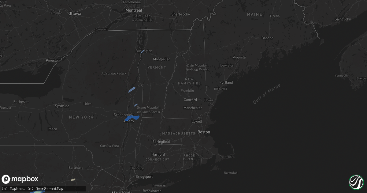
Hail Map in Vermont on September 8, 2021
Get this storm
September 8 map
$229
one time, instant access
Download today. No call, no setup
Keep the $229
Bought the map and want the full workflow? Apply the entire $229 to a subscription within 7 days. None of it is wasted.
Every map, not just this one
This buys you this map. Subscription and you get every map we run, in the markets you choose from a few cities to whole states to nationwide. Plus real-time alerts the moment a storm fires.
Contact data
Name, contact info, occupancy, even credit band for addresses in the footprint. You go from where it hit to who to call.
Become the source they trust
Unlimited branding weather history reports on demand. You already have the documented answer ready for the property owner, and you are the one who showed up with it.
Property data and RoofTrace estimates
Pull up any address you have got, its value and the exact code rules for that jurisdiction, straight from One Click Code. Then RoofTrace estimates the squares, pitch, and roof value, priced the way you price.
Storm reports in Vermont
Vermont
| Date | Description |
|---|---|
| 09/08/20214:53 PM CDT | Trees and lines down on route 116 |
| 09/08/20214:50 PM CDT | Trees and lines down on harbor road near shelburne point |
| 09/08/20214:48 PM CDT | Trees down on pond road |
| 09/08/20212:51 AM CDT | At 751 PM EDT, a severe thunderstorm was located over Wyantskill, or over Troy, moving northeast at 25 mph. HAZARD...70 mph wind gusts and nickel size hail. SOURCE...Radar indicated. IMPACT...Expect considerable tree damage. Damage is likely to mobile homes, roofs, and outbuildings. Locations impacted include... Troy, East Greenbush, Cohoes, Watervliet, Rensselaer, Hoosick Falls, Latham, Menands, Green Island, Grafton, Waterford, Berlin, West Sand Lake, Center Brunswick, Wyantskill, Averill Park, Wynantskill, Halfmoon, North Greenbush and Brunswick. |
| 09/08/20212:34 AM CDT | At 734 PM EDT, a severe thunderstorm was located near Greenwich, or near Salem, moving northeast at 45 mph. HAZARD...60 mph wind gusts. SOURCE...Radar indicated. IMPACT...Expect damage to roofs, siding, and trees. Locations impacted include... Salem, Dorset, Greenwich, Manchester Center, Porter, Rupert, Sandgate, Cossayuna, Beartown, Braymer School, Battenville, Center Falls, Goose Island, East Hebron, Rexleigh, Tiplady, Middle Falls, Eagleville, West Pawlet and North Cambridge. |
| 09/08/20211:51 AM CDT | At 650 PM EDT, a severe thunderstorm was located near Fort Edward, or near Hudson Falls, moving northeast at 45 mph. HAZARD...60 mph wind gusts. SOURCE...Radar indicated. IMPACT...Expect damage to roofs, siding, and trees. Locations impacted include... Hudson Falls, Fort Edward, Granville, Hartford, Kingsbury, Porter, Northumberland, South Glens Falls, Schuylerville, Rupert, Victory, Argyle, Cossayuna, Dunham Basin, Smiths Basin, Goose Island, Adamsville, Grangerville, North Granville and East Hebron. |
| 09/08/20211:33 AM CDT | At 633 PM EDT, a severe thunderstorm was located over Lake George Village, moving northeast at 55 mph. HAZARD...60 mph wind gusts. SOURCE...Radar indicated. IMPACT...Expect damage to roofs, siding, and trees. Locations impacted include... Glens Falls, Warrensburg, Whitehall, Lake George Village, Comstock, Bolton Landing, West Glens Falls, Glens Falls North, Huletts Landing, Putnam, Queensbury, Kingsbury, Mount Hope, Bolton, Hampton, Lake George, Fort Ann, Cleverdale, Putnam Station and South Bay Village. |
| 09/07/20217:25 PM CDT | Wires down. Fire department was dispatched. Time estimated by radar. |
All States Impacted by Hail Map on September 8, 2021
Cities Impacted by Hail Map on September 8, 2021
- Dunn, NC
- Newton Grove, NC
- Fayetteville, NC
- New Oxford, PA
- Gettysburg, PA
- East Berlin, PA
- Abbottstown, PA
- Dover, PA
- Biglerville, PA
- Orrtanna, PA
- York Springs, PA
- Aspers, PA
- Yorktown, VA
- Seaford, VA
- Norfolk, VA
- Black Mountain, NC
- Louisburg, NC
- Cerro Gordo, NC
- Evergreen, NC
- Chadbourn, NC
- San Angelo, TX
- Benson, NC
- Four Oaks, NC
- Myersville, MD
- Rutherfordton, NC
- Middleburg, PA
- Mount Pleasant Mills, PA
- Port Trevorton, PA
- Selinsgrove, PA
- Freeburg, PA
- Richfield, PA
- Eden, TX
- Moncks Corner, SC
- Bonneau, SC
- Forest City, NC
- Carrollton, VA
- Sunset, SC
- Centre, AL
- Cedar Bluff, AL
- Leesburg, AL
- Brady, TX
- Camden, NC
- Kingsville, MD
- Lancaster, SC
- Wade, NC
- Chesterfield, SC
- Mertzon, TX
- Heath Springs, SC
- Hendersonville, NC
- Godwin, NC
- Cross, SC
- Saint Marys, GA
- Yulee, FL
- North Wilkesboro, NC
- Roaring River, NC
- Williamsburg, VA
- Mason, TX
- Perry Hall, MD
- Glen Arm, MD
- Hydes, MD
- Fork, MD
- Bostic, NC
- Ellenboro, NC
- Henderson, NC
- North Augusta, SC
- Horse Shoe, NC
- Mills River, NC
- Fort Eustis, VA
- Newport News, VA
- Smithfield, VA
- Surry, VA
- Clewiston, FL
- Monroe, NC
- Taylorsville, NC
- Hayes, VA
- Gloucester, VA
- Brookfield, CT
- Danbury, CT
- Christoval, TX
- Menard, TX
- Gustine, TX
- Hamilton, TX
- Jasper, FL
- Granite Falls, NC
- Union Mills, NC
- Warrenton, NC
- Fairfield, PA
- Sonora, TX
- Minonk, IL
- Littleton, NC
- Macon, NC
- Lawn, TX
- Ovalo, TX
- Mocksville, NC
- Fair Bluff, NC
- Orrum, NC
- Mill Spring, NC
- Carlton, TX
- La Place, LA
- Hiddenite, NC
- Cheraw, SC
- Loxahatchee, FL
- West Palm Beach, FL
- San Saba, TX
- Asheboro, NC
- Orlando, FL
- Lenoir, NC
- Lake Lure, NC
- Virginia Beach, VA
- Knoxville, MD
- Jefferson, MD
- Marion, NC
- Voss, TX
- Millersview, TX
- Miles, TX
- Fort Monroe, VA
- Sharpsburg, MD
- Keedysville, MD
- Thurmont, MD
- Emmitsburg, MD
- Sabillasville, MD
- Disputanta, VA
- Lawrenceville, GA
- Suwanee, GA
- Freeland, PA
- White Haven, PA
- Lake Harmony, PA
- Franklin, VA
- Beavertown, PA
- Goldsboro, TX
- Melvin, TX
- Burlington, VT
- Shelburne, VT
- Lake George, NY
- Fort Ann, NY
- Kattskill Bay, NY
- Queensbury, NY
- Greenwich, NY
- Watervliet, NY
- Petersburg, NY
- Waterford, NY
- Troy, NY
- Cohoes, NY
- Cropseyville, NY
- Slingerlands, NY
- Poestenkill, NY
- Averill Park, NY
- Wynantskill, NY
- Latham, NY
- Albany, NY
- Panacea, FL
- Yeagertown, PA
- McClure, PA
- Lewistown, PA
- McAlisterville, PA
- Mifflintown, PA
- McVeytown, PA
- Herndon, PA
- Beaver Springs, PA
- Cocolamus, PA
- Burnham, PA
- Belleville, PA
- Dornsife, PA
- Sunbury, PA
- Newmanstown, PA
- Lititz, PA
- Womelsdorf, PA
- Myerstown, PA
- Wernersville, PA
- Oley, PA
- Denver, PA
- Stevens, PA
- Reinholds, PA
- Lebanon, PA
- Fleetwood, PA
- Douglassville, PA
- Robesonia, PA
- Schaefferstown, PA
- Birdsboro, PA
- Reading, PA
- Temple, PA


