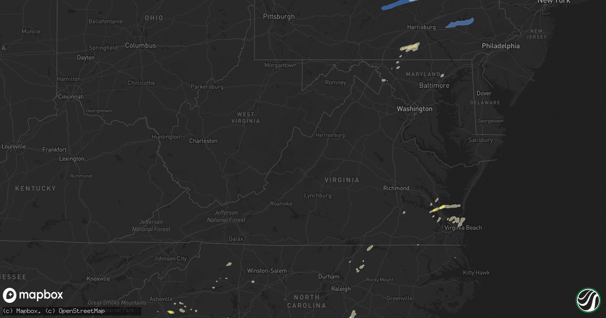
Hail Map in Virginia on September 8, 2021
Get this storm
September 8 map
$229
one time, instant access
Download today. No call, no setup
Keep the $229
Bought the map and want the full workflow? Apply the entire $229 to a subscription within 7 days. None of it is wasted.
Every map, not just this one
This buys you this map. Subscription and you get every map we run, in the markets you choose from a few cities to whole states to nationwide. Plus real-time alerts the moment a storm fires.
Contact data
Name, contact info, occupancy, even credit band for addresses in the footprint. You go from where it hit to who to call.
Become the source they trust
Unlimited branding weather history reports on demand. You already have the documented answer ready for the property owner, and you are the one who showed up with it.
Property data and RoofTrace estimates
Pull up any address you have got, its value and the exact code rules for that jurisdiction, straight from One Click Code. Then RoofTrace estimates the squares, pitch, and roof value, priced the way you price.
Storm reports in Virginia
Virginia
| Date | Description |
|---|---|
| 09/08/20214:20 PM CDT | Reports of hail up to half dollar size in seaford. |
| 09/08/20212:15 PM CDT | Down tree on rt. 629 near freedom goode road. Time estimated from radar. |
| 09/08/20212:14 PM CDT | Downed tree on us-17 near featherbed lane. Time estimated from radar. |
| 09/08/20211:57 PM CDT | Tree down on outside awning. |
| 09/08/20211:50 PM CDT | Tree down east of saluda. |
| 09/08/20211:15 PM CDT | Downed tree blocking roadway on rt. 629 near jackson road. Time estimated from radar. |
| 09/08/20211:00 PM CDT | Trees down on the eastbound lanes of interstate 64 at mm 213. Time estimated from radar. |
| 09/08/20214:11 AM CDT | At 911 PM EDT, severe thunderstorms were located along a line extending from near Shepherdstown to near Corporation Of Ranson, moving east at 20 mph. HAZARD...60 mph wind gusts and quarter size hail. SOURCE...Radar indicated. IMPACT...Damaging winds will cause some trees and large branches to fall. This could injure those outdoors, as well as damage homes and vehicles. Roadways may become blocked by downed trees. Localized power outages are possible. Unsecured light objects may become projectiles. Locations impacted include... Frederick, Charles Town, Harry Grove Stadium, Ballenger Creek, Brunswick, Walkersville, Ranson, Boonsboro, Braddock Heights, Mount Lena, San Mar, Harpers Ferry, Corporation Of Ranson, Clover Hill, Discovery-Spring Garden, Point Of Rocks, Linganore-Bartonsville, Adamstown, Jefferson and Myersville. |
| 09/08/202112:50 AM CDT | At 549 PM EDT, a severe thunderstorm was located 9 miles northeast of Louisburg, moving northeast at 20 mph. HAZARD...60 mph wind gusts and quarter size hail. SOURCE...Radar indicated. IMPACT...Hail damage to vehicles is expected. Expect wind damage to roofs, siding, and trees. Locations impacted include... Roanoke Rapids, Warrenton, Littleton, Weldon, Macon, Centerville, Ingleside, Medoc Mountain State Park, Afton and Lake Gaston. |
| 09/08/202112:16 AM CDT | At 516 PM EDT, a severe thunderstorm was located near Fort Eustis, or 7 miles northwest of Newport News, moving east at 20 mph. HAZARD...60 mph wind gusts and quarter size hail. SOURCE...Radar indicated. IMPACT...Minor damage to vehicles is possible. Expect wind damage to trees and powerlines. This severe thunderstorm will be near... Fort Eustis, Grove and Busch Gardens around 525 PM EDT. Lee Hall around 530 PM EDT. Denbigh around 535 PM EDT. Newport News and Patrick Henry Field around 540 PM EDT. Tabb around 545 PM EDT. Virginia Institute For Marine Sciences, Gloucester Point and Wicomico around 550 PM EDT. Seaford around 555 PM EDT. Achilles around 600 PM EDT.Other locations impacted by this severe thunderstorm include Lackey,Glass, Naxera, Oriana, Maryus, Dare, Newport News Golf Course,Severn, Oyster Point and Hog Island Game Reserve. |
| 09/07/202110:52 PM CDT | At 352 PM EDT, a severe thunderstorm was located 7 miles southeast of Lawsonia, or 18 miles southwest of Pocomoke City, moving east at 40 mph. HAZARD...60 mph wind gusts and penny size hail. SOURCE...Radar indicated. IMPACT...Expect damage to trees and powerlines. This severe thunderstorm will be near... Parksley around 400 PM EDT.Other locations impacted by this severe thunderstorm includeHorntown, Hallwood, Mappsville, Byrdtown, Greenbackville, Saxis,Wallops Island, Temperanceville, Nelsonia and Shelltown. |
| 09/07/202110:24 PM CDT | At 324 PM EDT, a severe thunderstorm was located over Thaxton, or near Montvale, moving northeast at 30 mph. HAZARD...60 mph wind gusts and quarter size hail. SOURCE...Radar indicated. IMPACT...Hail damage to vehicles is expected. Expect wind damage to roofs, siding, and trees. Locations impacted include... Bedford... Glasgow... Montvale... Big Island... Coleman Falls... Peaks Of Otter Summit... and Peaks Of Otter Recreation Area.This includes The following Location The National D-Day Memorial. |
| 09/07/202110:10 PM CDT | At 310 PM EDT, a severe thunderstorm was located over Wicomico, or near Gloucester Point, moving northeast at 20 mph. HAZARD...60 mph wind gusts and nickel size hail. SOURCE...Radar indicated. IMPACT...Expect damage to trees and powerlines. This severe thunderstorm will be near... Gloucester Courthouse, Hayes and Achilles around 320 PM EDT. Mobjack around 340 PM EDT. Bavon around 345 PM EDT. Mathews and Blakes around 350 PM EDT. Deltaville and Gwynn around 400 PM EDT.Other locations impacted by this severe thunderstorm include Ruff,Beulah, Moon, Laban, Glass, Naxera, Amburg, Fort Nonsense, Clay Bankand North. |
| 09/07/20219:58 PM CDT | At 258 PM EDT, a severe thunderstorm was located near Dahlgren, moving northeast at 30 mph. HAZARD...60 mph wind gusts. SOURCE...Radar indicated. IMPACT...Damaging winds will cause some trees and large branches to fall. This could injure those outdoors, as well as damage homes and vehicles. Roadways may become blocked by downed trees. Localized power outages are possible. Unsecured light objects may become projectiles. Locations impacted include... King George, Dahlgren, Potomac Beach, Rollins Fork, Ninde, Jersey and Shiloh. |
| 09/07/20219:43 PM CDT | At 242 PM EDT, a severe thunderstorm was located near Callaway, or near Ferrum, moving east at 20 mph. HAZARD...60 mph wind gusts and quarter size hail. SOURCE...Radar indicated. IMPACT...Hail damage to vehicles is expected. Expect wind damage to roofs, siding, and trees. Locations impacted include... Rocky Mount... Ferrum... Penhook... Burnt Chimney... Northwest Smith Mountain Lake... Westlake Corner... and Southern Smith Mountain Lake. |
| 09/07/20219:29 PM CDT | At 229 PM EDT, a severe thunderstorm was located over Barhamsville, or near Toano, moving northeast at 30 mph. HAZARD...60 mph wind gusts and nickel size hail. SOURCE...Radar indicated. IMPACT...Expect damage to trees and powerlines. This severe thunderstorm will be near... West Point around 240 PM EDT. Shacklefords around 245 PM EDT. Glenns around 255 PM EDT. Urbanna, Saluda and Church View around 300 PM EDT.Other locations impacted by this severe thunderstorm include Eltham,Harmony Village, Grafton, Harcum, Cash, Lanexa, Mattaponi, Warner,Warren Mill and Mascot. |
| 09/07/20218:46 PM CDT | At 146 PM EDT, a severe thunderstorm was located near Highland Springs, moving northeast at 25 mph. HAZARD...60 mph wind gusts and quarter size hail. SOURCE...Radar indicated. IMPACT...Minor damage to vehicles is possible. Expect wind damage to trees and powerlines. This severe thunderstorm will be near... Highland Springs around 150 PM EDT. Bottoms Bridge around 200 PM EDT. Tunstall around 220 PM EDT. Manquin around 225 PM EDT. King William and Aylett around 230 PM EDT.Other locations impacted by this severe thunderstorm include CentralGarage, Richmond Heights, Orapax Farms, Montrose, Sandston, Westwood,Rose Garden, Richmond International, Quinton and Fair Oaks. |
| 09/07/20218:32 PM CDT | At 130 PM EDT, a severe thunderstorm was located near Low Gap, moving northeast at 25 mph. HAZARD...60 mph wind gusts and quarter size hail. SOURCE...Radar indicated. IMPACT...Hail damage to vehicles is expected. Expect wind damage to roofs, siding, and trees. Locations impacted include... Mount Airy... Flat Rock... Bottom... Cana... Pine Ridge... Toast... and Lambsburg. |
| 09/07/20218:26 PM CDT | At 126 PM EDT, a severe thunderstorm was located near Disputanta, moving northeast at 30 mph. HAZARD...60 mph wind gusts and nickel size hail. SOURCE...Radar indicated. IMPACT...Expect damage to trees and powerlines. This severe thunderstorm will be near... Disputanta around 135 PM EDT. Garysville around 150 PM EDT. Burrowsville and Cabin Point around 155 PM EDT. Charles City and Claremont around 205 PM EDT. Ruthville around 210 PM EDT. Rustic and Holdcroft around 215 PM EDT.Other locations impacted by this severe thunderstorm include TaylorsCorner, Chickahominy Shore, Templeton, Prince George Golf, SpringGrove, Brandon, Oak Hill Corner, New Hope, Savedge and Barham. |
| 09/07/20218:24 PM CDT | At 123 PM EDT, a severe thunderstorm was located over Hillsville, moving east at 20 mph. HAZARD...60 mph wind gusts and quarter size hail. SOURCE...Radar indicated. IMPACT...Hail damage to vehicles is expected. Expect wind damage to roofs, siding, and trees. Locations impacted include... Hillsville... Dugspur... Woodlawn... and Gladesboro. |
All States Impacted by Hail Map on September 8, 2021
Cities Impacted by Hail Map on September 8, 2021
- Dunn, NC
- Newton Grove, NC
- Fayetteville, NC
- New Oxford, PA
- Gettysburg, PA
- East Berlin, PA
- Abbottstown, PA
- Dover, PA
- Biglerville, PA
- Orrtanna, PA
- York Springs, PA
- Aspers, PA
- Yorktown, VA
- Seaford, VA
- Norfolk, VA
- Black Mountain, NC
- Louisburg, NC
- Cerro Gordo, NC
- Evergreen, NC
- Chadbourn, NC
- San Angelo, TX
- Benson, NC
- Four Oaks, NC
- Myersville, MD
- Rutherfordton, NC
- Middleburg, PA
- Mount Pleasant Mills, PA
- Port Trevorton, PA
- Selinsgrove, PA
- Freeburg, PA
- Richfield, PA
- Eden, TX
- Moncks Corner, SC
- Bonneau, SC
- Forest City, NC
- Carrollton, VA
- Sunset, SC
- Centre, AL
- Cedar Bluff, AL
- Leesburg, AL
- Brady, TX
- Camden, NC
- Kingsville, MD
- Lancaster, SC
- Wade, NC
- Chesterfield, SC
- Mertzon, TX
- Heath Springs, SC
- Hendersonville, NC
- Godwin, NC
- Cross, SC
- Saint Marys, GA
- Yulee, FL
- North Wilkesboro, NC
- Roaring River, NC
- Williamsburg, VA
- Mason, TX
- Perry Hall, MD
- Glen Arm, MD
- Hydes, MD
- Fork, MD
- Bostic, NC
- Ellenboro, NC
- Henderson, NC
- North Augusta, SC
- Horse Shoe, NC
- Mills River, NC
- Fort Eustis, VA
- Newport News, VA
- Smithfield, VA
- Surry, VA
- Clewiston, FL
- Monroe, NC
- Taylorsville, NC
- Hayes, VA
- Gloucester, VA
- Brookfield, CT
- Danbury, CT
- Christoval, TX
- Menard, TX
- Gustine, TX
- Hamilton, TX
- Jasper, FL
- Granite Falls, NC
- Union Mills, NC
- Warrenton, NC
- Fairfield, PA
- Sonora, TX
- Minonk, IL
- Littleton, NC
- Macon, NC
- Lawn, TX
- Ovalo, TX
- Mocksville, NC
- Fair Bluff, NC
- Orrum, NC
- Mill Spring, NC
- Carlton, TX
- La Place, LA
- Hiddenite, NC
- Cheraw, SC
- Loxahatchee, FL
- West Palm Beach, FL
- San Saba, TX
- Asheboro, NC
- Orlando, FL
- Lenoir, NC
- Lake Lure, NC
- Virginia Beach, VA
- Knoxville, MD
- Jefferson, MD
- Marion, NC
- Voss, TX
- Millersview, TX
- Miles, TX
- Fort Monroe, VA
- Sharpsburg, MD
- Keedysville, MD
- Thurmont, MD
- Emmitsburg, MD
- Sabillasville, MD
- Disputanta, VA
- Lawrenceville, GA
- Suwanee, GA
- Freeland, PA
- White Haven, PA
- Lake Harmony, PA
- Franklin, VA
- Beavertown, PA
- Goldsboro, TX
- Melvin, TX
- Burlington, VT
- Shelburne, VT
- Lake George, NY
- Fort Ann, NY
- Kattskill Bay, NY
- Queensbury, NY
- Greenwich, NY
- Watervliet, NY
- Petersburg, NY
- Waterford, NY
- Troy, NY
- Cohoes, NY
- Cropseyville, NY
- Slingerlands, NY
- Poestenkill, NY
- Averill Park, NY
- Wynantskill, NY
- Latham, NY
- Albany, NY
- Panacea, FL
- Yeagertown, PA
- McClure, PA
- Lewistown, PA
- McAlisterville, PA
- Mifflintown, PA
- McVeytown, PA
- Herndon, PA
- Beaver Springs, PA
- Cocolamus, PA
- Burnham, PA
- Belleville, PA
- Dornsife, PA
- Sunbury, PA
- Newmanstown, PA
- Lititz, PA
- Womelsdorf, PA
- Myerstown, PA
- Wernersville, PA
- Oley, PA
- Denver, PA
- Stevens, PA
- Reinholds, PA
- Lebanon, PA
- Fleetwood, PA
- Douglassville, PA
- Robesonia, PA
- Schaefferstown, PA
- Birdsboro, PA
- Reading, PA
- Temple, PA


