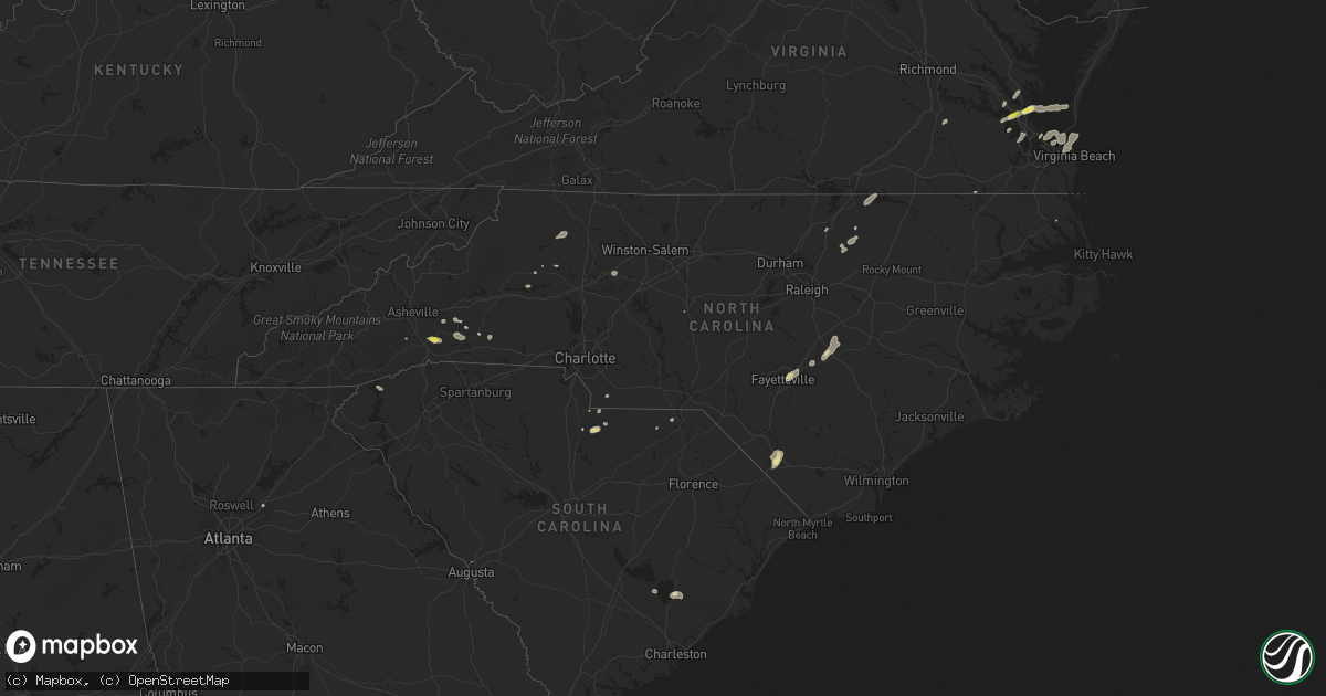
Hail Map in North Carolina on September 8, 2021
Get this storm
September 8 map
$229
one time, instant access
Download today. No call, no setup
Keep the $229
Bought the map and want the full workflow? Apply the entire $229 to a subscription within 7 days. None of it is wasted.
Every map, not just this one
This buys you this map. Subscription and you get every map we run, in the markets you choose from a few cities to whole states to nationwide. Plus real-time alerts the moment a storm fires.
Contact data
Name, contact info, occupancy, even credit band for addresses in the footprint. You go from where it hit to who to call.
Become the source they trust
Unlimited branding weather history reports on demand. You already have the documented answer ready for the property owner, and you are the one who showed up with it.
Property data and RoofTrace estimates
Pull up any address you have got, its value and the exact code rules for that jurisdiction, straight from One Click Code. Then RoofTrace estimates the squares, pitch, and roof value, priced the way you price.
Storm reports in North Carolina
North Carolina
| Date | Description |
|---|---|
| 09/08/20216:08 PM CDT | Tree down. |
| 09/08/20215:31 PM CDT | One tree reported down near highway 158. |
| 09/08/20215:10 PM CDT | Trained spotter reported tree down on church on sheffield rd. Roof damage was reported. |
| 09/08/20213:55 PM CDT | Large tree blown down on macedonia church road across from the sun-do kwik shop... Near the columbus/robeson county line |
| 09/08/20213:50 PM CDT | Tree down on power line. |
| 09/08/20212:40 PM CDT | Tree down along old u.s. 421b. Time estimated from radar. |
| 09/08/20211:30 PM CDT | 911 call center reported a tree down on maple creek rd |
| 09/08/202112:38 PM CDT | Dime to quarter sized hail for about 5 minutes. Very little wind. About one mile south of edneyville. |
| 09/08/20211:28 AM CDT | At 628 PM EDT, a severe thunderstorm was located near Mocksville, moving east at 25 mph. HAZARD...60 mph wind gusts and quarter size hail. SOURCE...Radar indicated. IMPACT...Minor hail damage to vehicles is expected. Expect wind damage to trees and power lines. Locations impacted include... Mocksville, Bermuda Run, Cooleemee, Fork Church and Advance. |
| 09/08/20211:12 AM CDT | At 612 PM EDT, a severe thunderstorm was located near Benson, or 17 miles southwest of Smithfield, moving northeast at 30 mph. HAZARD...60 mph wind gusts and quarter size hail. SOURCE...Radar indicated. IMPACT...Hail damage to vehicles is expected. Expect wind damage to roofs, siding, and trees. Locations impacted include... Smithfield, Clayton, Dunn, Benson, Micro, Selma, Erwin, Coats, Four Oaks and Pine Level. |
| 09/08/202112:34 AM CDT | At 534 PM EDT, a severe thunderstorm was located 7 miles east of Fayetteville, moving northeast at 20 mph. HAZARD...60 mph wind gusts and quarter size hail. SOURCE...Radar indicated. IMPACT...Hail damage to vehicles is expected. Expect wind damage to roofs, siding, and trees. Locations impacted include... Fayetteville, Lillington, Fort Bragg, Dunn, Godwin, Pope AFB, Spring Lake, Erwin, Eastover and Coats. |
| 09/07/202111:47 PM CDT | At 447 PM EDT, a severe thunderstorm was located over Evergreen, or 12 miles west of Whiteville, moving northeast at 25 mph. HAZARD...60 mph wind gusts and nickel size hail. SOURCE...Radar indicated. IMPACT...Expect wind damage to trees and power lines. Locations impacted include... Chadbourn, Bladenboro, Boardman, Abbottsburg, Butters, Barnesville, Evergreen, Southeastern Community College, Cerro Gordo, Marietta, Proctorville and Orrum. |
| 09/07/202110:31 PM CDT | At 331 PM EDT, a severe thunderstorm was located over Pleasant Hill, or over Elkin, moving east at 20 mph. HAZARD...60 mph wind gusts and quarter size hail. SOURCE...Radar indicated. IMPACT...Hail damage to vehicles is expected. Expect wind damage to roofs, siding, and trees. Locations impacted include... Elkin... Fairview... Jonesville... Boonville... Nebo... State Road... and Level Cross. |
| 09/07/202110:04 PM CDT | At 304 PM EDT, a severe thunderstorm was located near Wilkes County Airport, or near Ronda, moving east at 10 mph. HAZARD...60 mph wind gusts and quarter size hail. SOURCE...Radar indicated. IMPACT...Hail damage to vehicles is expected. Expect wind damage to roofs, siding, and trees. Locations impacted include... North Wilkesboro... Wilkesboro... Ronda... Traphill... Mulberry... Buck... and Millers Creek. |
| 09/07/20219:20 PM CDT | At 220 PM EDT, a severe thunderstorm was located near Woodville, or near Flat Rock, moving east at 20 mph. HAZARD...60 mph wind gusts and quarter size hail. SOURCE...Radar indicated. IMPACT...Hail damage to vehicles is expected. Expect wind damage to roofs, siding, and trees. Locations impacted include... Mount Airy... and Flat Rock. |
| 09/07/20219:15 PM CDT | At 215 PM EDT, a severe thunderstorm was located over Benham, or near Traphill, moving east at 20 mph. HAZARD...60 mph wind gusts and quarter size hail. SOURCE...Radar indicated. IMPACT...Hail damage to vehicles is expected. Expect wind damage to roofs, siding, and trees. Locations impacted include... Elkin... Mountain Park... Benham... State Road... and Dockery. |
| 09/07/20219:12 PM CDT | At 212 PM EDT, a severe thunderstorm was located 6 miles northwest of Rutherfordton, moving east at 15 mph. HAZARD...60 mph wind gusts and quarter size hail. SOURCE...Radar indicated. IMPACT...Minor hail damage to vehicles is expected. Expect wind damage to trees and power lines. Locations impacted include... Forest City, Rutherfordton, Spindale, Ellenboro, Bostic, Green Hill, Thermal City, Henrietta, Sunshine and Lake Adger. |
| 09/07/20219:10 PM CDT | At 210 PM EDT, a severe thunderstorm was located near Elgin, or near Lancaster, moving northeast at 10 mph. HAZARD...60 mph wind gusts and quarter size hail. SOURCE...Radar indicated. IMPACT...Hail damage to vehicles is expected. Expect wind damage to roofs, siding, and trees. Locations impacted include... Lancaster, Elgin, Heath Springs, Irwin, Buford, Tradesville, Camp Creek Fire Station, Antioch, Kirk Air Base, Faith Christian School, Forty Acre Rock Preserve, Taxahaw, Pleasant Hill, Kershaw Correctional Institution, Unity Fire Station, Lancaster Mill, Bear Creek Park and McDonald Green Elementary School. |
| 09/07/20219:07 PM CDT | At 207 PM EDT, a severe thunderstorm was located 7 miles north of Hickory, or near Lake Hickory, moving northeast at 15 mph. HAZARD...60 mph wind gusts and quarter size hail. SOURCE...Radar indicated. IMPACT...Minor hail damage to vehicles is expected. Expect wind damage to trees and power lines. Locations impacted include... Taylorsville, Bethlehem, Lake Hickory, Hiddenite, Northlakes, Little River In Alexander County, Vashti, Millersville, Ellendale and Granite Falls. |
| 09/07/20219:03 PM CDT | At 203 PM EDT, a severe thunderstorm was located 8 miles west of Morganton, or near Lake James, moving east at 10 mph. HAZARD...60 mph wind gusts and quarter size hail. SOURCE...Radar indicated. IMPACT...Minor hail damage to vehicles is expected. Expect wind damage to trees and power lines. Locations impacted include... Morganton, Valdese, Drexel, Connelly Springs, Rutherford College, Glen Alpine, Lake Rhodhiss, Table Rock, Oak Hill and Lake James. |
| 09/07/20218:36 PM CDT | At 136 PM EDT, a severe thunderstorm was located 10 miles northeast of Hendersonville, or 4 miles south of Bat Cave, moving east at 25 mph. HAZARD...60 mph wind gusts and quarter size hail. SOURCE...Radar indicated. IMPACT...Minor hail damage to vehicles is expected. Expect wind damage to trees and power lines. Locations impacted include... Forest City, Rutherfordton, Spindale, Lake Lure, Bostic, Chimney Rock Village, Chimney Rock State Park, Bat Cave, Green Hill and Mill Spring. |
All States Impacted by Hail Map on September 8, 2021
Cities Impacted by Hail Map on September 8, 2021
- Dunn, NC
- Newton Grove, NC
- Fayetteville, NC
- New Oxford, PA
- Gettysburg, PA
- East Berlin, PA
- Abbottstown, PA
- Dover, PA
- Biglerville, PA
- Orrtanna, PA
- York Springs, PA
- Aspers, PA
- Yorktown, VA
- Seaford, VA
- Norfolk, VA
- Black Mountain, NC
- Louisburg, NC
- Cerro Gordo, NC
- Evergreen, NC
- Chadbourn, NC
- San Angelo, TX
- Benson, NC
- Four Oaks, NC
- Myersville, MD
- Rutherfordton, NC
- Middleburg, PA
- Mount Pleasant Mills, PA
- Port Trevorton, PA
- Selinsgrove, PA
- Freeburg, PA
- Richfield, PA
- Eden, TX
- Moncks Corner, SC
- Bonneau, SC
- Forest City, NC
- Carrollton, VA
- Sunset, SC
- Centre, AL
- Cedar Bluff, AL
- Leesburg, AL
- Brady, TX
- Camden, NC
- Kingsville, MD
- Lancaster, SC
- Wade, NC
- Chesterfield, SC
- Mertzon, TX
- Heath Springs, SC
- Hendersonville, NC
- Godwin, NC
- Cross, SC
- Saint Marys, GA
- Yulee, FL
- North Wilkesboro, NC
- Roaring River, NC
- Williamsburg, VA
- Mason, TX
- Perry Hall, MD
- Glen Arm, MD
- Hydes, MD
- Fork, MD
- Bostic, NC
- Ellenboro, NC
- Henderson, NC
- North Augusta, SC
- Horse Shoe, NC
- Mills River, NC
- Fort Eustis, VA
- Newport News, VA
- Smithfield, VA
- Surry, VA
- Clewiston, FL
- Monroe, NC
- Taylorsville, NC
- Hayes, VA
- Gloucester, VA
- Brookfield, CT
- Danbury, CT
- Christoval, TX
- Menard, TX
- Gustine, TX
- Hamilton, TX
- Jasper, FL
- Granite Falls, NC
- Union Mills, NC
- Warrenton, NC
- Fairfield, PA
- Sonora, TX
- Minonk, IL
- Littleton, NC
- Macon, NC
- Lawn, TX
- Ovalo, TX
- Mocksville, NC
- Fair Bluff, NC
- Orrum, NC
- Mill Spring, NC
- Carlton, TX
- La Place, LA
- Hiddenite, NC
- Cheraw, SC
- Loxahatchee, FL
- West Palm Beach, FL
- San Saba, TX
- Asheboro, NC
- Orlando, FL
- Lenoir, NC
- Lake Lure, NC
- Virginia Beach, VA
- Knoxville, MD
- Jefferson, MD
- Marion, NC
- Voss, TX
- Millersview, TX
- Miles, TX
- Fort Monroe, VA
- Sharpsburg, MD
- Keedysville, MD
- Thurmont, MD
- Emmitsburg, MD
- Sabillasville, MD
- Disputanta, VA
- Lawrenceville, GA
- Suwanee, GA
- Freeland, PA
- White Haven, PA
- Lake Harmony, PA
- Franklin, VA
- Beavertown, PA
- Goldsboro, TX
- Melvin, TX
- Burlington, VT
- Shelburne, VT
- Lake George, NY
- Fort Ann, NY
- Kattskill Bay, NY
- Queensbury, NY
- Greenwich, NY
- Watervliet, NY
- Petersburg, NY
- Waterford, NY
- Troy, NY
- Cohoes, NY
- Cropseyville, NY
- Slingerlands, NY
- Poestenkill, NY
- Averill Park, NY
- Wynantskill, NY
- Latham, NY
- Albany, NY
- Panacea, FL
- Yeagertown, PA
- McClure, PA
- Lewistown, PA
- McAlisterville, PA
- Mifflintown, PA
- McVeytown, PA
- Herndon, PA
- Beaver Springs, PA
- Cocolamus, PA
- Burnham, PA
- Belleville, PA
- Dornsife, PA
- Sunbury, PA
- Newmanstown, PA
- Lititz, PA
- Womelsdorf, PA
- Myerstown, PA
- Wernersville, PA
- Oley, PA
- Denver, PA
- Stevens, PA
- Reinholds, PA
- Lebanon, PA
- Fleetwood, PA
- Douglassville, PA
- Robesonia, PA
- Schaefferstown, PA
- Birdsboro, PA
- Reading, PA
- Temple, PA


