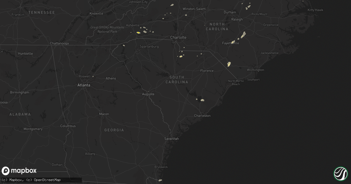
Hail Map in South Carolina on September 8, 2021
Get this storm
September 8 map
$229
one time, instant access
Download today. No call, no setup
Keep the $229
Bought the map and want the full workflow? Apply the entire $229 to a subscription within 7 days. None of it is wasted.
Every map, not just this one
This buys you this map. Subscription and you get every map we run, in the markets you choose from a few cities to whole states to nationwide. Plus real-time alerts the moment a storm fires.
Contact data
Name, contact info, occupancy, even credit band for addresses in the footprint. You go from where it hit to who to call.
Become the source they trust
Unlimited branding weather history reports on demand. You already have the documented answer ready for the property owner, and you are the one who showed up with it.
Property data and RoofTrace estimates
Pull up any address you have got, its value and the exact code rules for that jurisdiction, straight from One Click Code. Then RoofTrace estimates the squares, pitch, and roof value, priced the way you price.
Storm reports in South Carolina
South Carolina
| Date | Description |
|---|---|
| 09/08/20214:40 PM CDT | 2-3 trees are down in the beaufort and port royal areas. Some trees have downed powerlines. |
| 09/08/20214:05 PM CDT | Social media picture from the burton fire department showed a large tree down on a car and home. Time estimated from radar data. |
| 09/08/20211:30 PM CDT | Public reported quarter sized hail near mcilwain rd and sentry rd. Time estimated. |
| 09/07/20219:06 PM CDT | At 206 PM EDT, a severe thunderstorm was located 11 miles northwest of Pickens, or near Jocassee Gorges, moving east at 10 mph. HAZARD...60 mph wind gusts and quarter size hail. SOURCE...Radar indicated. IMPACT...Minor hail damage to vehicles is expected. Expect wind damage to trees and power lines. Locations impacted include... Devils Fork State Park, Keowee Toxaway State Park, Table Rock State Park, Jocassee Gorges, Lake Jocassee, Sunset, Nine Times, Rocky Bottom, Sassafras Mountain and Pickens. |
All States Impacted by Hail Map on September 8, 2021
Cities Impacted by Hail Map on September 8, 2021
- Dunn, NC
- Newton Grove, NC
- Fayetteville, NC
- New Oxford, PA
- Gettysburg, PA
- East Berlin, PA
- Abbottstown, PA
- Dover, PA
- Biglerville, PA
- Orrtanna, PA
- York Springs, PA
- Aspers, PA
- Yorktown, VA
- Seaford, VA
- Norfolk, VA
- Black Mountain, NC
- Louisburg, NC
- Cerro Gordo, NC
- Evergreen, NC
- Chadbourn, NC
- San Angelo, TX
- Benson, NC
- Four Oaks, NC
- Myersville, MD
- Rutherfordton, NC
- Middleburg, PA
- Mount Pleasant Mills, PA
- Port Trevorton, PA
- Selinsgrove, PA
- Freeburg, PA
- Richfield, PA
- Eden, TX
- Moncks Corner, SC
- Bonneau, SC
- Forest City, NC
- Carrollton, VA
- Sunset, SC
- Centre, AL
- Cedar Bluff, AL
- Leesburg, AL
- Brady, TX
- Camden, NC
- Kingsville, MD
- Lancaster, SC
- Wade, NC
- Chesterfield, SC
- Mertzon, TX
- Heath Springs, SC
- Hendersonville, NC
- Godwin, NC
- Cross, SC
- Saint Marys, GA
- Yulee, FL
- North Wilkesboro, NC
- Roaring River, NC
- Williamsburg, VA
- Mason, TX
- Perry Hall, MD
- Glen Arm, MD
- Hydes, MD
- Fork, MD
- Bostic, NC
- Ellenboro, NC
- Henderson, NC
- North Augusta, SC
- Horse Shoe, NC
- Mills River, NC
- Fort Eustis, VA
- Newport News, VA
- Smithfield, VA
- Surry, VA
- Clewiston, FL
- Monroe, NC
- Taylorsville, NC
- Hayes, VA
- Gloucester, VA
- Brookfield, CT
- Danbury, CT
- Christoval, TX
- Menard, TX
- Gustine, TX
- Hamilton, TX
- Jasper, FL
- Granite Falls, NC
- Union Mills, NC
- Warrenton, NC
- Fairfield, PA
- Sonora, TX
- Minonk, IL
- Littleton, NC
- Macon, NC
- Lawn, TX
- Ovalo, TX
- Mocksville, NC
- Fair Bluff, NC
- Orrum, NC
- Mill Spring, NC
- Carlton, TX
- La Place, LA
- Hiddenite, NC
- Cheraw, SC
- Loxahatchee, FL
- West Palm Beach, FL
- San Saba, TX
- Asheboro, NC
- Orlando, FL
- Lenoir, NC
- Lake Lure, NC
- Virginia Beach, VA
- Knoxville, MD
- Jefferson, MD
- Marion, NC
- Voss, TX
- Millersview, TX
- Miles, TX
- Fort Monroe, VA
- Sharpsburg, MD
- Keedysville, MD
- Thurmont, MD
- Emmitsburg, MD
- Sabillasville, MD
- Disputanta, VA
- Lawrenceville, GA
- Suwanee, GA
- Freeland, PA
- White Haven, PA
- Lake Harmony, PA
- Franklin, VA
- Beavertown, PA
- Goldsboro, TX
- Melvin, TX
- Burlington, VT
- Shelburne, VT
- Lake George, NY
- Fort Ann, NY
- Kattskill Bay, NY
- Queensbury, NY
- Greenwich, NY
- Watervliet, NY
- Petersburg, NY
- Waterford, NY
- Troy, NY
- Cohoes, NY
- Cropseyville, NY
- Slingerlands, NY
- Poestenkill, NY
- Averill Park, NY
- Wynantskill, NY
- Latham, NY
- Albany, NY
- Panacea, FL
- Yeagertown, PA
- McClure, PA
- Lewistown, PA
- McAlisterville, PA
- Mifflintown, PA
- McVeytown, PA
- Herndon, PA
- Beaver Springs, PA
- Cocolamus, PA
- Burnham, PA
- Belleville, PA
- Dornsife, PA
- Sunbury, PA
- Newmanstown, PA
- Lititz, PA
- Womelsdorf, PA
- Myerstown, PA
- Wernersville, PA
- Oley, PA
- Denver, PA
- Stevens, PA
- Reinholds, PA
- Lebanon, PA
- Fleetwood, PA
- Douglassville, PA
- Robesonia, PA
- Schaefferstown, PA
- Birdsboro, PA
- Reading, PA
- Temple, PA


