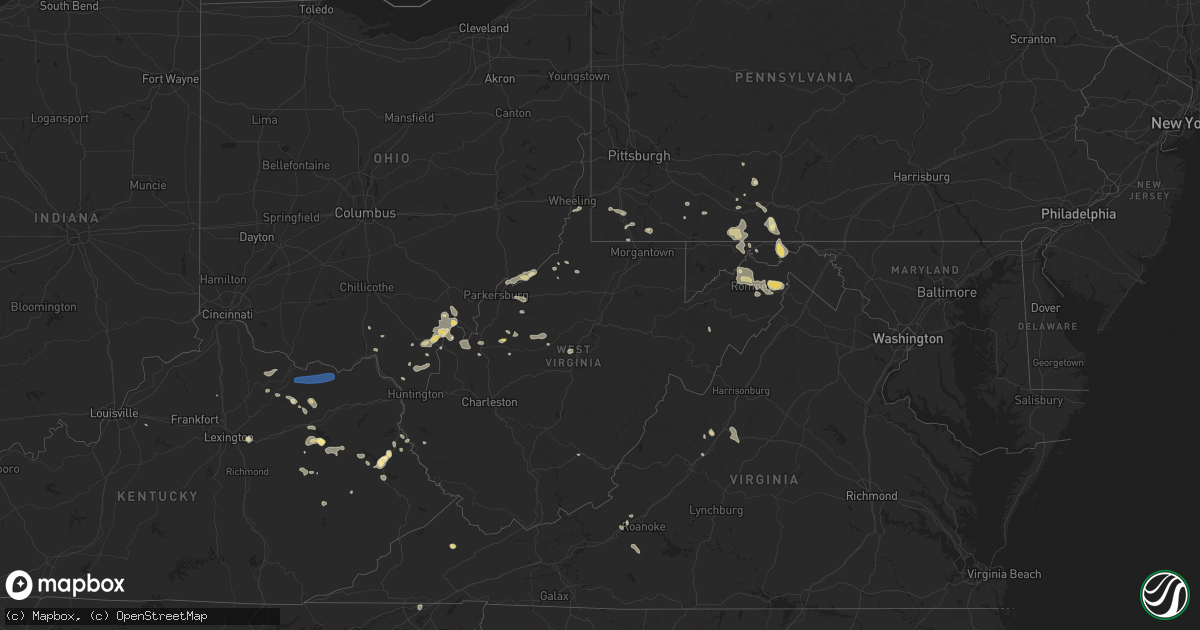
Hail Map in West Virginia on August 31, 2024
Get this storm
August 31 map
$229
one time, instant access
Download today. No call, no setup
Keep the $229
Bought the map and want the full workflow? Apply the entire $229 to a subscription within 7 days. None of it is wasted.
Every map, not just this one
This buys you this map. Subscription and you get every map we run, in the markets you choose from a few cities to whole states to nationwide. Plus real-time alerts the moment a storm fires.
Contact data
Name, contact info, occupancy, even credit band for addresses in the footprint. You go from where it hit to who to call.
Become the source they trust
Unlimited branding weather history reports on demand. You already have the documented answer ready for the property owner, and you are the one who showed up with it.
Property data and RoofTrace estimates
Pull up any address you have got, its value and the exact code rules for that jurisdiction, straight from One Click Code. Then RoofTrace estimates the squares, pitch, and roof value, priced the way you price.
Storm reports in West Virginia
West Virginia
| Date | Description |
|---|---|
| 08/31/20245:34 PM CDT | Tree down near church. |
| 08/31/20244:35 PM CDT | Several trees down in downtown martinsburg... King st and maple ave... Tennessee ave & old mill rd |
| 08/31/20244:23 PM CDT | Tree down on a house on south rosemont street. |
| 08/31/20244:12 PM CDT | Tree on powerline. |
| 08/31/20243:58 PM CDT | Tree down at the intersection of old route 55 and leisure acres rd |
| 08/31/20243:54 PM CDT | Tree down on route 50 near hanging rock. |
| 08/31/20243:54 PM CDT | One report of a tree down near capon bridge. |
| 08/31/20243:47 PM CDT | Trees and power lines down causing fire at route 53 and route 47 in petroleum. |
| 08/31/20243:41 PM CDT | Tree down on route 50 near shanks. |
| 08/31/20243:33 PM CDT | Tree down at the intersection of cherry ln and mccoole ave |
| 08/31/20243:28 PM CDT | Tree down on dans run rd in fort ashby |
| 08/31/20243:24 PM CDT | Three reports of trees down near romney. |
| 08/31/20242:50 PM CDT | One tree down blocking part of roadway near cedarville. Time estimated from radar. |
| 08/31/20242:50 PM CDT | Power lines down and blown transformer on rosemar terrace. |
| 08/31/20242:40 PM CDT | One tree and power lines down blocking road near diana. |
| 08/31/20242:24 PM CDT | One tree down along beverly creek drive. Time estimated from radar. |
| 08/31/20242:20 PM CDT | One tree fell in front of residence and was blocking roadway. Time estimated from radar. |
| 08/31/20242:15 PM CDT | Three trees down across rolling river road. One mile from cairo. |
| 08/31/20242:10 PM CDT | One tree down in walkersville at clapboard and two lick roads. Time estimated from radar. |
| 08/31/20242:08 PM CDT | Tree with power lines down blocking road near tallmansville. Time estimated from radar. |
| 08/31/20242:06 PM CDT | One tree blocking road... No power lines involved. Time estimated from radar. |
| 08/31/20242:03 PM CDT | One tree down blocking entire roadway. Time estimated from radar. |
| 08/31/20242:02 PM CDT | A couple of trees down... One large oak in roadway and another across a rail trail and almost onto a trailer. Time estimated from radar. |
| 08/31/20242:00 PM CDT | One tree down with power or phone line blocking entire roadway. Time estimated from radar. |
| 08/31/20242:00 PM CDT | Tree and lines down on bill grose road near sago road. |
| 08/31/20241:56 PM CDT | Tree down at the intersection of johnson run rd and kellers ridge rd |
| 08/31/20241:55 PM CDT | Downed tree reported on braxton street in gassaway. |
| 08/31/20241:55 PM CDT | Downed tree reported near exchange. |
| 08/31/20241:51 PM CDT | One tree down on power lines near residence near wabash ave. And lynch run rd. Time estimated from radar. |
| 08/31/20241:50 PM CDT | One tree down along coal river road in seth. Time estimated from radar. |
| 08/31/20241:50 PM CDT | One tree down with lines at football field. Time estimated from radar. |
| 08/31/20241:48 PM CDT | One tree down blocking roadway near seth. Time estimated from radar. |
| 08/31/20241:46 PM CDT | One tree down at craft drive and cabin creek road... Blocking part of roadway. Vehicles can squeeze by. Time estimated from radar. |
| 08/31/20241:30 PM CDT | Downed tree reported on e little kanawha highway. |
| 08/31/20241:30 PM CDT | Tree down along river road. Time estimated from radar. |
| 08/31/20241:25 PM CDT | One tree down blocking roadway. Time estimated from radar. |
| 08/31/20241:25 PM CDT | Tree and power lines down blocking roadway at the intersection of old taylortown road and lazzelle union road. Time estimated from radar. |
| 08/31/20241:00 PM CDT | Power lines down across shortline highway. Time estimated from radar. |
| 08/31/202412:28 PM CDT | 1 large tree down 1/4 mile from route 50 in petroleum. No power lines involved. Time estimated from radar. |
| 08/31/202412:25 PM CDT | Downed tree reported on union campground road. |
| 08/31/202412:12 PM CDT | Downed tree reported on ohio river road in west columbia. |
| 08/31/202412:10 PM CDT | Downed tree reported on ohio river road at camp conley road. |
| 08/31/202412:10 PM CDT | Downed tree reported on state farm road near ohio river road. |
| 08/31/202412:00 PM CDT | One tree down. Time estimated from radar via gust fromt well east of the storm. |
| 08/31/202412:00 PM CDT | Tree down. |
| 08/31/202412:00 PM CDT | Corrects previous tstm wnd dmg report from winfield. One tree down. Time estimated from radar via gust front well east of the storm. |
| 08/31/202411:59 AM CDT | One tree down... Time estimated from radar via gust front well southeast of the storm. |
| 08/31/202411:46 AM CDT | Downed lines reported at ultra lane in ashton. |
All States Impacted by Hail Map on August 31, 2024
Cities Impacted by Hail Map on August 31, 2024
- Maysville, KY
- Tollesboro, KY
- Flemingsburg, KY
- Vanceburg, KY
- Ironton, OH
- Kitts Hill, OH
- Frenchburg, KY
- Salt Lick, KY
- Scottown, OH
- Willow Wood, OH
- Crown City, OH
- Pedro, OH
- Wellington, KY
- West Liberty, KY
- Bidwell, OH
- Gallipolis, OH
- Patriot, OH
- Ezel, KY
- Louisa, KY
- Cheshire, OH
- Fort Gay, WV
- River, KY
- Lowmansville, KY
- Gallipolis Ferry, WV
- Waverly, WV
- Saint Marys, WV
- Point Pleasant, WV
- Glen Dale, WV
- Wheeling, WV
- Moundsville, WV
- Ulysses, KY
- Tutor Key, KY
- Paintsville, KY
- Petroleum, WV
- West Columbia, WV
- Mason, WV
- Pomeroy, OH
- Cottageville, WV
- Mount Alto, WV
- Salyersville, KY
- Letart, WV
- Hartford, WV
- Racine, OH
- Middleport, OH
- Tomahawk, KY
- Sistersville, WV
- Friendly, WV
- Middlebourne, WV
- Windber, PA
- Oil Springs, KY
- Wittensville, KY
- Inez, KY
- Dunlow, WV
- Porters Falls, WV
- Reader, WV
- New Martinsville, WV
- Stambaugh, KY
- Ripley, WV
- Le Roy, WV
- Reedy, WV
- Jacksonburg, WV
- Sandyville, WV
- Staffordsville, KY
- Hagerhill, KY
- Sitka, KY
- Spencer, WV
- Graysville, PA
- Prosperity, PA
- Waynesburg, PA
- Sycamore, PA
- Mount Morris, PA
- Mount Olivet, KY
- Carlisle, KY
- Jackson, KY
- Carmichaels, PA
- Campton, KY
- Prestonsburg, KY
- East Point, KY
- Palestine, WV
- Creston, WV
- Thelma, KY
- West Van Lear, KY
- Scott City, MO
- Mount Zion, WV
- Grantsville, WV
- Arnoldsburg, WV
- Masontown, PA
- Smithfield, PA
- Martin, PA
- Greensboro, PA
- Beattyville, KY
- Rogers, KY
- Shade, OH
- Walker, WV
- Normalville, PA
- Acme, PA
- Johnstown, PA
- Mineral Point, PA
- Elizabeth, WV
- Slade, KY
- Normantown, WV
- Winchester, KY
- Lexington, KY
- Ewing, KY
- Schellsburg, PA
- Rockwood, PA
- Mill Run, PA
- Exchange, WV
- Stoystown, PA
- Cairnbrook, PA
- Central City, PA
- Cairo, WV
- Cedarville, WV
- Crawley, WV
- Smoot, WV
- Friedens, PA
- Berlin, PA
- Manns Choice, PA
- Petersburg, WV
- Hillsboro, KY
- Waiteville, WV
- Newport, OH
- Reno, OH
- Marietta, OH
- Wallingford, KY
- Brooksville, KY
- Germantown, KY
- Frostburg, MD
- Rutland, OH
- Meyersdale, PA
- Fairhope, PA
- Williamstown, WV
- Bedford, PA
- Everett, PA
- Clearville, PA
- Wellersburg, PA
- Hyndman, PA
- Honaker, VA
- Rowe, VA
- Mount Savage, MD
- Cumberland, MD
- Ridgeley, WV
- Keyser, WV
- Langsville, OH
- Lyerly, GA
- Beaver, OH
- Lucasville, OH
- New Matamoras, OH
- Burlington, WV
- Flintstone, MD
- Fort Ashby, WV
- Morehead, KY
- Romney, WV
- Summerville, GA
- Rome, GA
- Sacramento, KY
- Cabins, WV
- Minford, OH
- Artemas, PA
- Little Orleans, MD
- Oldtown, MD
- Portsmouth, OH
- Springfield, WV
- Great Cacapon, WV
- Augusta, WV
- Shanks, WV
- Points, WV
- Slanesville, WV
- Pine Ridge, KY
- Salem, VA
- Capon Bridge, WV
- Olympia, KY
- Oak Hill, OH
- Thurman, OH
- Paw Paw, WV
- Bloomery, WV
- Blaine, KY
- Sylacauga, AL
- Rockford, AL
- Goodwater, AL
- Leon, WV
- Swoope, VA
- Bristol, VA
- Blountville, TN
- Kingsport, TN
- Staunton, VA
- Middlebrook, VA
- Easley, SC
- Greenville, SC
- Taylors, SC
- Greer, SC
- Fairfield, VA
- Fishersville, VA
- Waynesboro, VA
- Simpsonville, KY
- Fisherville, KY
- Mauldin, SC
- Afton, VA
- Stuarts Draft, VA
- Lyndhurst, VA
- Callaway, VA
- Boones Mill, VA
- Rocky Mount, VA
- Sadieville, KY
- Roma, TX
- Finchville, KY
- Mayslick, KY


