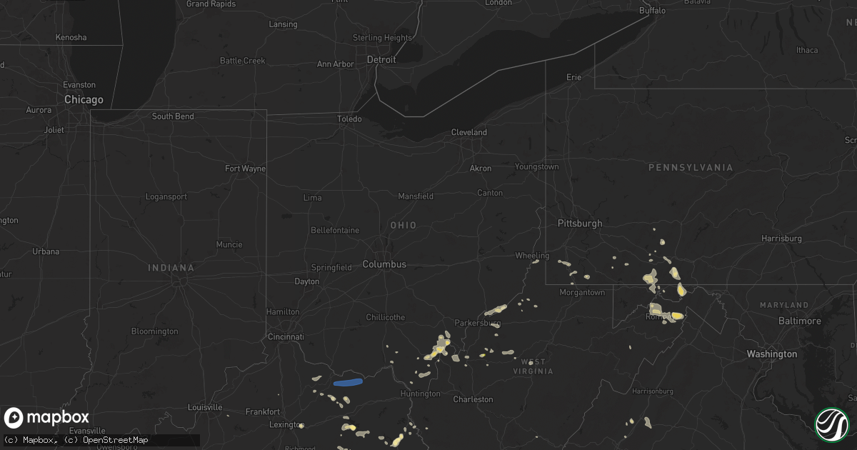
Hail Map in Ohio on August 31, 2024
Get this storm
August 31 map
$229
one time, instant access
Download today. No call, no setup
Keep the $229
Bought the map and want the full workflow? Apply the entire $229 to a subscription within 7 days. None of it is wasted.
Every map, not just this one
This buys you this map. Subscription and you get every map we run, in the markets you choose from a few cities to whole states to nationwide. Plus real-time alerts the moment a storm fires.
Contact data
Name, contact info, occupancy, even credit band for addresses in the footprint. You go from where it hit to who to call.
Become the source they trust
Unlimited branding weather history reports on demand. You already have the documented answer ready for the property owner, and you are the one who showed up with it.
Property data and RoofTrace estimates
Pull up any address you have got, its value and the exact code rules for that jurisdiction, straight from One Click Code. Then RoofTrace estimates the squares, pitch, and roof value, priced the way you price.
Storm reports in Ohio
Ohio
| Date | Description |
|---|---|
| 08/31/20244:23 PM CDT | Tree down blocking entire roadway on route 141 between cr 7 and cr 7e. Time estimated from radar. |
| 08/31/20244:00 PM CDT | Debris hitting the windows. Have several large downed trees on the property and on house. Trampoline folded around my car. |
| 08/31/20244:00 PM CDT | Tree on powerline. Time estimated from radar. |
| 08/31/20243:20 PM CDT | Tree on power line. |
| 08/31/20243:18 PM CDT | Tree down between state route 93 and gallia rd. |
| 08/31/20243:09 PM CDT | Tree on power line. |
All States Impacted by Hail Map on August 31, 2024
Cities Impacted by Hail Map on August 31, 2024
- Maysville, KY
- Tollesboro, KY
- Flemingsburg, KY
- Vanceburg, KY
- Ironton, OH
- Kitts Hill, OH
- Frenchburg, KY
- Salt Lick, KY
- Scottown, OH
- Willow Wood, OH
- Crown City, OH
- Pedro, OH
- Wellington, KY
- West Liberty, KY
- Bidwell, OH
- Gallipolis, OH
- Patriot, OH
- Ezel, KY
- Louisa, KY
- Cheshire, OH
- Fort Gay, WV
- River, KY
- Lowmansville, KY
- Gallipolis Ferry, WV
- Waverly, WV
- Saint Marys, WV
- Point Pleasant, WV
- Glen Dale, WV
- Wheeling, WV
- Moundsville, WV
- Ulysses, KY
- Tutor Key, KY
- Paintsville, KY
- Petroleum, WV
- West Columbia, WV
- Mason, WV
- Pomeroy, OH
- Cottageville, WV
- Mount Alto, WV
- Salyersville, KY
- Letart, WV
- Hartford, WV
- Racine, OH
- Middleport, OH
- Tomahawk, KY
- Sistersville, WV
- Friendly, WV
- Middlebourne, WV
- Windber, PA
- Oil Springs, KY
- Wittensville, KY
- Inez, KY
- Dunlow, WV
- Porters Falls, WV
- Reader, WV
- New Martinsville, WV
- Stambaugh, KY
- Ripley, WV
- Le Roy, WV
- Reedy, WV
- Jacksonburg, WV
- Sandyville, WV
- Staffordsville, KY
- Hagerhill, KY
- Sitka, KY
- Spencer, WV
- Graysville, PA
- Prosperity, PA
- Waynesburg, PA
- Sycamore, PA
- Mount Morris, PA
- Mount Olivet, KY
- Carlisle, KY
- Jackson, KY
- Carmichaels, PA
- Campton, KY
- Prestonsburg, KY
- East Point, KY
- Palestine, WV
- Creston, WV
- Thelma, KY
- West Van Lear, KY
- Scott City, MO
- Mount Zion, WV
- Grantsville, WV
- Arnoldsburg, WV
- Masontown, PA
- Smithfield, PA
- Martin, PA
- Greensboro, PA
- Beattyville, KY
- Rogers, KY
- Shade, OH
- Walker, WV
- Normalville, PA
- Acme, PA
- Johnstown, PA
- Mineral Point, PA
- Elizabeth, WV
- Slade, KY
- Normantown, WV
- Winchester, KY
- Lexington, KY
- Ewing, KY
- Schellsburg, PA
- Rockwood, PA
- Mill Run, PA
- Exchange, WV
- Stoystown, PA
- Cairnbrook, PA
- Central City, PA
- Cairo, WV
- Cedarville, WV
- Crawley, WV
- Smoot, WV
- Friedens, PA
- Berlin, PA
- Manns Choice, PA
- Petersburg, WV
- Hillsboro, KY
- Waiteville, WV
- Newport, OH
- Reno, OH
- Marietta, OH
- Wallingford, KY
- Brooksville, KY
- Germantown, KY
- Frostburg, MD
- Rutland, OH
- Meyersdale, PA
- Fairhope, PA
- Williamstown, WV
- Bedford, PA
- Everett, PA
- Clearville, PA
- Wellersburg, PA
- Hyndman, PA
- Honaker, VA
- Rowe, VA
- Mount Savage, MD
- Cumberland, MD
- Ridgeley, WV
- Keyser, WV
- Langsville, OH
- Lyerly, GA
- Beaver, OH
- Lucasville, OH
- New Matamoras, OH
- Burlington, WV
- Flintstone, MD
- Fort Ashby, WV
- Morehead, KY
- Romney, WV
- Summerville, GA
- Rome, GA
- Sacramento, KY
- Cabins, WV
- Minford, OH
- Artemas, PA
- Little Orleans, MD
- Oldtown, MD
- Portsmouth, OH
- Springfield, WV
- Great Cacapon, WV
- Augusta, WV
- Shanks, WV
- Points, WV
- Slanesville, WV
- Pine Ridge, KY
- Salem, VA
- Capon Bridge, WV
- Olympia, KY
- Oak Hill, OH
- Thurman, OH
- Paw Paw, WV
- Bloomery, WV
- Blaine, KY
- Sylacauga, AL
- Rockford, AL
- Goodwater, AL
- Leon, WV
- Swoope, VA
- Bristol, VA
- Blountville, TN
- Kingsport, TN
- Staunton, VA
- Middlebrook, VA
- Easley, SC
- Greenville, SC
- Taylors, SC
- Greer, SC
- Fairfield, VA
- Fishersville, VA
- Waynesboro, VA
- Simpsonville, KY
- Fisherville, KY
- Mauldin, SC
- Afton, VA
- Stuarts Draft, VA
- Lyndhurst, VA
- Callaway, VA
- Boones Mill, VA
- Rocky Mount, VA
- Sadieville, KY
- Roma, TX
- Finchville, KY
- Mayslick, KY


