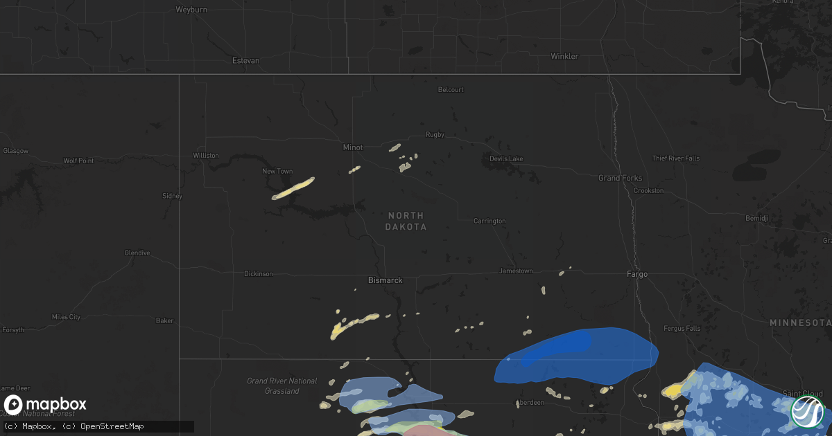
Hail Map in North Dakota on August 23, 2021
Get this storm
August 23 map
$229
one time, instant access
Download today. No call, no setup
Keep the $229
Bought the map and want the full workflow? Apply the entire $229 to a subscription within 7 days. None of it is wasted.
Every map, not just this one
This buys you this map. Subscription and you get every map we run, in the markets you choose from a few cities to whole states to nationwide. Plus real-time alerts the moment a storm fires.
Contact data
Name, contact info, occupancy, even credit band for addresses in the footprint. You go from where it hit to who to call.
Become the source they trust
Unlimited branding weather history reports on demand. You already have the documented answer ready for the property owner, and you are the one who showed up with it.
Property data and RoofTrace estimates
Pull up any address you have got, its value and the exact code rules for that jurisdiction, straight from One Click Code. Then RoofTrace estimates the squares, pitch, and roof value, priced the way you price.
Storm reports in North Dakota
North Dakota
| Date | Description |
|---|---|
| 08/23/20215:06 AM CDT | At 1006 PM CDT, a severe thunderstorm was located 7 miles northwest of Fort Yates, moving northeast at 50 mph. HAZARD...60 mph wind gusts and quarter size hail. SOURCE...Radar indicated. IMPACT...Hail damage to vehicles is expected. Expect wind damage to roofs, siding, and trees. This severe thunderstorm will be near... Fort Yates around 1010 PM CDT. Prairie Knights Resort around 1020 PM CDT. |
| 08/23/20212:15 AM CDT | Several large 3 to 5 inch diameter tree branches broken down around a farmstead. Very strong winds occurred for about 10 minutes... From 210 am through 220 am cdt. |
| 08/23/20211:59 AM CDT | Peak wind measured at an nddot rwis station. |
| 08/23/20211:56 AM CDT | Peak wind reported at an ndawn station at 10 meters. |
| 08/23/20211:02 AM CDT | Personal weather station in oakes measured 70 mph sustained wind gusting to 97 mph. |
| 08/23/202112:17 AM CDT | At 514 PM MDT, severe thunderstorms were located along a line extending from 11 miles north of Camp Crook to 5 miles north of Hoover, moving northeast at 45 mph. HAZARD...70 mph wind gusts. SOURCE...Radar indicated. IMPACT...Expect considerable tree damage. Damage is likely to mobile homes, roofs, and outbuildings. Locations impacted include... Buffalo, Bison, Ludlow, Reva, Ralph, Sorum, Date, Prairie City, Ladner, Slim Buttes, Owen Lake, South Cave Hills, Sheep Buttes, Lake Gardner, Table Mountain and North Cave Hills. |
All States Impacted by Hail Map on August 23, 2021
Cities Impacted by Hail Map on August 23, 2021
- Northfield, MN
- Farwell, MN
- Kensington, MN
- Forbes, ND
- Leola, SD
- Ellsworth, WI
- Bay City, WI
- Saint Francis, SD
- Wellsville, MO
- Bayard, NM
- Hanover, NM
- Frankford, MO
- Max, ND
- Sawyer, ND
- Valley City, ND
- Benson, MN
- Milan, MN
- Montevideo, MN
- Clara City, MN
- Appleton, MN
- Danvers, MN
- Clarkfield, MN
- Maynard, MN
- Boyd, MN
- Glenwood, MN
- Lowry, MN
- Starbuck, MN
- Sauk Centre, MN
- Villard, MN
- Brooten, MN
- Revere, MN
- Walnut Grove, MN
- Alton, MO
- Couch, MO
- Douglas, AZ
- Lamberton, MN
- Westbrook, MN
- Thedford, NE
- White River, SD
- Dupree, SD
- Saint Charles, MO
- Golden Eagle, IL
- Brussels, IL
- Cosmos, MN
- Litchfield, MN
- Festus, MO
- Fults, IL
- Bloomsdale, MO
- Valmeyer, IL
- Saint Cloud, MN
- Kimball, MN
- Renville, MN
- Sacred Heart, MN
- Lakeside, NE
- Valentine, NE
- Johnstown, NE
- Gaylord, MN
- Capitan, NM
- Hondo, NM
- Turton, SD
- Conde, SD
- Alexandria, MN
- Parshall, ND
- Granite Falls, MN
- Elfrida, AZ
- Harrisonville, PA
- Breezewood, PA
- Crystal Spring, PA
- Eau Claire, WI
- Goodhue, MN
- Murdock, MN
- Eagle Butte, SD
- Hoven, SD
- Gettysburg, SD
- Lebanon, SD
- Olivia, MN
- Danube, MN
- Tombstone, AZ
- Timber Lake, SD
- Ellsworth, NE
- Belgrade, MN
- Sterling, IL
- Dixon, IL
- Polo, IL
- Elko New Market, MN
- Montgomery, MN
- Lonsdale, MN
- Webster, MN
- Dundas, MN
- Faribault, MN
- McIntosh, SD
- Garretson, SD
- Henderson, MN
- Green Isle, MN
- Lordsburg, NM
- Drake, ND
- Eden Prairie, MN
- Minnetonka, MN
- Hanley Falls, MN
- Magdalena, NM
- Holloway, MN
- Hancock, MN
- Shipman, IL
- Brighton, IL
- Le Sueur, MN
- Saint Louis, MO
- Meadow, SD
- Morris, MN
- Chokio, MN
- Dumont, MN
- Saint Paul, MN
- Madison, MN
- Canby, MN
- Burnsville, MN
- Middletown, MO
- Rushville, IL
- Virginia, IL
- Arenzville, IL
- Frederick, IL
- Beardstown, IL
- Ashland, IL
- Alexander, IL
- Jacksonville, IL
- Mount Sterling, IL
- Centerville, MO
- Potosi, MO
- Flasher, ND
- Solen, ND
- Cold Spring, MN
- Sainte Genevieve, MO
- Farmington, MO
- Saint Mary, MO
- Lake City, MN
- Frontenac, MN
- Red Wing, MN
- Tolstoy, SD
- Becker, MN
- Monticello, MN
- Clear Lake, MN
- Alma, WI
- Mondovi, WI
- Nelson, WI
- Durand, WI
- Eleva, WI
- McNeal, AZ
- Glencross, SD
- McLaughlin, SD
- Isabel, SD
- Bingham, NE
- Saint Peters, MO
- Fullerton, ND
- Ellendale, ND
- Watauga, SD
- Wakpala, SD
- Vienna, MO
- Belle, MO
- Karlsruhe, ND
- Grove City, MN
- Atwater, MN
- Chadwick, IL
- Covington, LA
- Ponchatoula, LA
- New Salem, ND
- Sisseton, SD
- Melrose, MN
- Paynesville, MN
- New London, MN
- Belleville, IL
- Shakopee, MN
- Belle Plaine, MN
- South Haven, MN
- Clearwater, MN
- Maple Lake, MN
- Annandale, MN
- Prior Lake, MN
- New Prague, MN
- Jordan, MN
- Minneota, MN
- Taunton, MN
- Porter, MN
- Ivanhoe, MN
- Pepin, WI
- Ellington, MO
- Seneca, SD
- Delano, MN
- Alberta, MN
- Graceville, MN
- Deming, NM
- Whitehorse, SD
- Elmwood, WI
- Odessa, MN
- Bellingham, MN
- Hopkins, MN
- Minneapolis, MN
- Cyrus, MN
- Selfridge, ND
- Watson, MN
- Lehr, ND
- Tyler, MN
- Ghent, MN
- Arco, MN
- Marshall, MN
- Russell, MN
- Lynd, MN
- Rugby, ND
- Clark, SD
- Raymond, SD
- Milbank, SD
- Towner, ND
- Savage, MN
- Florence, SD
- Henry, SD
- Harmon, IL
- Rock Falls, IL
- Raleigh, ND
- Eden, SD
- Willernie, MN
- Java, SD
- Selby, SD
- Lucan, MN
- Riverton, NE
- Bonne Terre, MO
- French Village, MO
- Bowling Green, MO
- Curryville, MO
- Cokato, MN
- Roscoe, MN
- Buffalo, MN
- Darwin, MN
- Watkins, MN
- Dassel, MN
- Richmond, MN
- Rockville, MN
- Eden Valley, MN
- Randolph, MN
- Cannon Falls, MN
- Birch Tree, MO
- Crystal City, MO
- Tracy, MN
- Currie, MN
- Higden, AR
- Lake Lillian, MN
- Carson, ND
- Ipswich, SD
- Aberdeen, SD
- Groton, SD
- Independence, WI
- Berlin, ND
- Balaton, MN
- Melbourne, AR
- Mount Pleasant, AR
- Killdeer, ND
- Roseglen, ND
- Webster, SD
- Madisonville, LA
- Wabasso, MN
- Vesta, MN
- Beardsley, MN
- Andover, MN
- Cedar, MN
- Wyoming, MN
- Mountain View, AR
- Plaza, ND
- Ryder, ND
- Correll, MN
- Millville, MN
- Storden, MN
- De Soto, MO
- Montrose, MN
- Waverly, MN
- Hamburg, MN
- Milroy, MN
- Garvin, MN
- Norwood Young America, MN
- Bellflower, MO
- Jonesburg, MO
- High Hill, MO
- Shields, ND
- East Saint Louis, IL
- Fairview Heights, IL
- Collinsville, IL
- Caseyville, IL
- Vandalia, MO
- Balfour, ND
- Hector, MN
- Okaton, SD
- Montgomery City, MO
- Warrenton, MO
- Herman, MN
- Hoffman, MN
- Donnelly, MN
- Sunburg, MN
- Mandaree, ND
- Linton, ND
- Hazelton, ND
- Menomonie, WI
- Eau Galle, WI
- Milledgeville, IL
- Faulkton, SD
- Baton Rouge, LA
- Prairieville, LA
- Saint Gabriel, LA
- Oriska, ND
- Lakeville, MN
- Union, MO
- Strum, WI
- Whitehall, WI
- Big Stone City, SD
- Hager City, WI
- Las Cruces, NM
- Portage Des Sioux, MO
- Piasa, IL
- Minot, ND
- Welch, MN
- Madison, IL
- Venice, IL
- Granite City, IL
- Rincon, NM
- Litchville, ND
- Chaska, MN
- Dawson, MN
- Raymond, MN
- Bald Knob, AR
- Maple Plain, MN
- Wright City, MO
- Truesdale, MO
- Cave City, AR
- Cologne, MN
- Hastings, MN
- Carver, MN
- Saint Peter, MN
- Farmington, MN
- Dennison, MN
- Hampton, MN
- Le Center, MN
- Spring Valley, WI
- Murdo, SD
- Evening Shade, AR
- Anoka, MN
- Mandan, ND
- Trail City, SD
- Bunker, MO
- Loretto, MN
- Rockford, MN
- Howard Lake, MN
- Pleasant Plains, IL
- New Berlin, IL
- Redwood Falls, MN
- Wishek, ND
- Judsonia, AR
- Winsted, MN
- Bowdle, SD
- Roscoe, SD
- Onaka, SD
- Arlington, MN
- Blomkest, MN
- Prinsburg, MN
- Echo, MN
- Andover, SD
- Bradley, SD
- Stockholm, WI
- Maiden Rock, WI
- Bird Island, MN
- Robert, LA
- Makoti, ND
- Mountainair, NM
- Berger, MO
- Ridgeview, SD
- Saint Michael, MN
- Clontarf, MN
- Elrosa, MN
- Hutchinson, MN
- Lester Prairie, MN
- Saint Martin, MN
- Mayer, MN
- Spicer, MN
- Willmar, MN
- Elk River, MN
- New Germany, MN
- Watertown, MN
- Freeport, MN
- Evansville, MN
- Silver Lake, MN
- Barrett, MN
- Big Lake, MN
- Avon, MN
- Albany, MN
- Stewart, MN
- Kerkhoven, MN
- Saint Joseph, MN
- Kandiyohi, MN
- Albertville, MN
- Buffalo Lake, MN
- Osakis, MN
- Brandon, MN
- Glencoe, MN
- Pennock, MN
- Lantry, SD
- Little Eagle, SD
- Glenham, SD
- Mound City, SD
- Mobridge, SD
- Akaska, SD
- Hankinson, ND
- Fairmount, ND
- Stirum, ND
- Claire City, SD
- Westport, SD
- Columbia, SD
- Oakes, ND
- Rosholt, SD
- Wheaton, MN
- Britton, SD
- Gwinner, ND
- Tintah, MN
- Houghton, SD
- Cogswell, ND
- Lake City, SD
- Barney, ND
- Havana, ND
- Amherst, SD
- Veblen, SD
- New Effington, SD
- Mantador, ND
- Forman, ND
- Wyndmere, ND
- Milnor, ND
- Barnard, SD
- Cayuga, ND
- Mooreton, ND
- Frederick, SD
- Campbell, MN
- Claremont, SD
- Wahpeton, ND
- Hecla, SD
- Lidgerwood, ND
- Rutland, ND
- Augusta, MO
- Marlborough, MA
- Bolton, MA


