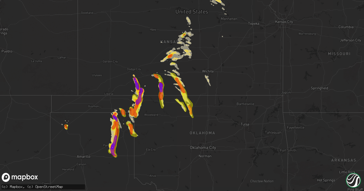
Hail Map on September 8, 2025
Get this storm
September 8 map
$229
one time, instant access
Download today. No call, no setup
Keep the $229
Bought the map and want the full workflow? Apply the entire $229 to a subscription within 7 days. None of it is wasted.
Every map, not just this one
This buys you this map. Subscription and you get every map we run, in the markets you choose from a few cities to whole states to nationwide. Plus real-time alerts the moment a storm fires.
Contact data
Name, contact info, occupancy, even credit band for addresses in the footprint. You go from where it hit to who to call.
Become the source they trust
Unlimited branding weather history reports on demand. You already have the documented answer ready for the property owner, and you are the one who showed up with it.
Property data and RoofTrace estimates
Pull up any address you have got, its value and the exact code rules for that jurisdiction, straight from One Click Code. Then RoofTrace estimates the squares, pitch, and roof value, priced the way you price.
States Impacted by Hail Map on September 8, 2025
Storm reports
Oklahoma
| Date | Description |
|---|---|
| 09/08/20256:25 PM CDT | Location and time are approximate. |
| 09/08/20255:57 PM CDT | Brief tornado observed by storm chasers. |
| 09/07/20257:50 PM CDT | Delayed report. Location approximate. |
| 09/07/20257:50 PM CDT | Delayed report. Relayed by emergency management. Location approximate. |
| 09/07/20257:49 PM CDT | Approximate location. |
| 09/07/20257:37 PM CDT | A local report indicates 1.00 inch wind near 4 ESE Carrier |
| 09/07/20257:22 PM CDT | A local report indicates 1.50 inch wind near Hillsdale |
| 09/07/20257:00 PM CDT | A local report indicates 1.75 inch wind near Laverne |
Nebraska
| Date | Description |
|---|---|
| 09/08/20256:32 PM CDT | Report from mping: half dollar |
| 09/08/20256:25 PM CDT | A local report indicates 1.50 inch wind near 1 NE Valentine |
| 09/08/20256:18 PM CDT | Delayed report of hail 1.75 inches and rainfall of 0.65 inches... Estimated time via radar. |
| 09/08/202512:51 AM CDT | A local report indicates 1.00 inch wind near 1 S Kearney |
| 09/07/20257:39 PM CDT | Station vrfn1. |
| 09/07/20257:01 PM CDT | A local report indicates 1.00 inch wind near Valentine |
Kansas
| Date | Description |
|---|---|
| 09/08/20256:45 PM CDT | A local report indicates 1.00 inch wind near Minneola |
| 09/08/20256:43 PM CDT | Report was from social media with pictures. |
| 09/08/20256:43 PM CDT | A local report indicates 3.00 inch wind near Minneola |
| 09/08/20256:42 PM CDT | A local report indicates 1.00 inch wind near 8 S Minneola |
| 09/08/20256:33 PM CDT | A local report indicates 2.75 inch wind near 9 ESE Wilmore |
| 09/08/20255:15 PM CDT | Measured 3.5 inches. |
| 09/08/20255:15 PM CDT | Measured about 3.5 inches. |
| 09/08/20255:09 PM CDT | A local report indicates 1.00 inch wind near Ashland |
| 09/08/20255:00 PM CDT | A local report indicates 3.00 inch wind near Ashland |
| 09/08/20254:41 PM CDT | A local report indicates 1.00 inch wind near Greensburg |
| 09/08/20251:45 PM CDT | A local report indicates 1.00 inch wind near 2 NNW Neola |
| 09/08/20259:45 AM CDT | A local report indicates 1.75 inch wind near 4 N Hudson |
| 09/08/20259:45 AM CDT | A local report indicates 1.75 inch wind near Hudson |
| 09/08/20259:31 AM CDT | A local report indicates 1.25 inch wind near 6 N Saint John |
| 09/08/20257:20 AM CDT | A local report indicates 1.00 inch wind near Ellsworth |
| 09/07/20257:08 PM CDT | A local report indicates 2.00 inch wind near 8 WSW Clark State Lake |
Utah
| Date | Description |
|---|---|
| 09/08/20253:10 AM CDT | Mesonet station ut29 plymouth. |
Colorado
| Date | Description |
|---|---|
| 09/07/20257:05 PM CDT | Convective wind gust. |
South Dakota
| Date | Description |
|---|---|
| 09/08/20253:02 AM CDT | Wind caused a 6 foot by 8 foot metal shed not anchored to the ground to be tipped over. 0.76 inches of rain reported... As was some standing water approximately 5 hours |
Texas
| Date | Description |
|---|---|
| 09/08/20256:52 PM CDT | A local report indicates 3.50 inch wind near 4 E Perryton |
| 09/08/20256:45 PM CDT | Baseball size hail was falling at the time of the report. |
| 09/08/20256:42 PM CDT | Picture sent through social media. |
| 09/08/20256:35 PM CDT | Picture on social media. Windshield had significant hail damage. |
| 09/08/20256:15 PM CDT | Picture submitted on social media. |
| 09/08/20255:45 PM CDT | Mostly nickel hail with some golf ball size mixed in. |
| 09/08/20255:44 PM CDT | A local report indicates 1.00 inch wind near 1 E Dalhart |
| 09/07/202510:38 PM CDT | Corrects previous hail report from lefors. Multip |
| 09/07/202510:38 PM CDT | Corrects previous hail report from lefors. Multiple r |
| 09/07/202510:38 PM CDT | Corrects previous hail report from lefors. Multiple reports of tennis ball to baseball size hail; at least one car windshield destroyed. |
| 09/07/20259:15 PM CDT | Picture of multiple golf ball sized hail... And some tennis ball hail as well. |
| 09/07/20258:36 PM CDT | Corrects previous hail report from 12 sw wolf creek park. Social media report. |
| 09/07/20258:28 PM CDT | Picture from social media. |
| 09/07/20258:06 PM CDT | A local report indicates 1.25 inch wind near 8 SSW Wolf Creek Park |
| 09/07/20257:29 PM CDT | Perryton fire and rescue reported the hail on social media. |
| 09/07/20257:25 PM CDT | A local report indicates 1.00 inch wind near 1 NNE Wolf Creek Park |
| 09/07/20257:05 PM CDT | Video of a tornado on the ground sent through social media. |
| 09/07/20257:00 PM CDT | Social media report. |
Cities Impacted by Hail Map on September 8, 2025
- Brookville, KS
- Ellsworth, KS
- Kanopolis, KS
- Rosston, OK
- Follett, TX
- Lincoln, KS
- Higgins, TX
- Beverly, KS
- Belpre, KS
- Macksville, KS
- Hudson, KS
- Ellinwood, KS
- St John, KS
- Larned, KS
- Bushton, KS
- Great Bend, KS
- Geneseo, KS
- Lorraine, KS
- Holyrood, KS
- Lyons, KS
- Durham, OK
- Stafford, KS
- Sylvia, KS
- Beloit, KS
- Barnard, KS
- Pratt, KS
- Plevna, KS
- Sterling, KS
- Abbyville, KS
- Isabel, KS
- Nickerson, KS
- Sawyer, KS
- Chase, KS
- Olmitz, KS
- Raymond, KS
- Little River, KS
- Marquette, KS
- Alden, KS
- Hines, MN
- Turon, KS
- Blackduck, MN
- Northome, MN
- Cunningham, KS
- Hutchinson, KS
- Nashville, KS
- Inman, KS
- Zenda, KS
- Spivey, KS
- Attica, KS
- Medicine Lodge, KS
- Ashland, KS
- Haviland, KS
- Sharon, KS
- Hazelton, KS
- Mullinville, KS
- Greensburg, KS
- Burlington, OK
- Alva, OK
- Cherokee, OK
- Waldron, KS
- Dalhart, TX
- Valentine, NE
- Buffalo, OK
- Balko, OK
- Anthony, KS
- Sun City, KS
- Antelope, OR
- Mission, SD
- Selfridge, ND
- Englewood, KS
- Cody, NE
- Laverne, OK
- Winner, SD
- Perryton, TX
- Helena, OK
- Jet, OK
- Goltry, OK
- Wilmore, KS
- Manchester, OK
- Amorita, OK
- Lake City, KS
- Minneola, KS
- Booker, TX
- Dodge City, KS
- Seneca, NE
- Wakita, OK
- Nash, OK
- Witten, SD
- Gate, OK
- Pond Creek, OK
- Coldwater, KS
- Fargo, OK
- Shattuck, OK
- Strasburg, ND
- Enid, OK
- Carrier, OK
- Kremlin, OK
- Haysville, KS
- Clearwater, KS
- Peck, KS
- Ashwood, OR
- Beaver, OK
- Freedom, OK
- Belle Plaine, KS
- Mulvane, KS
- Miami, TX
- Colome, SD
- Oxford, KS
- Wellington, KS
- Waynoka, OK
- Darrouzett, TX
- Stapleton, NE
- Lipscomb, TX
- Canadian, TX
- Pampa, TX
- Arnold, NE
- Anselmo, NE
- Arnett, OK
- Merna, NE
- Callaway, NE
- Broken Bow, NE
- Mclean, TX
- Hague, ND
- Oconto, NE
- Clarendon, TX
- Sumner, NE
- Grand Island, NE
- Miller, NE
- Doniphan, NE
- Amherst, NE
- Elm Creek, NE
- Phillips, NE
- Riverdale, NE
- Kearney, NE
- Overton, NE
- Trumbull, NE
- Kenesaw, NE
- Minden, NE
- Gibbon, NE
- Heartwell, NE
- Seneca, SD
- Glenvil, NE
- Hastings, NE
- Inland, NE
- Clay Center, NE
- Harvard, NE
- Aurora, NE
- McCool Junction, NE
- York, NE
- Exeter, NE
- Waco, NE
- Beaver Crossing, NE
- Staplehurst, NE
- Cresbard, SD
- Blue Hill, NE
- Seward, NE
- Goehner, NE
- Utica, NE
- Ipswich, SD
- Roscoe, SD
- Milford, NE
- Lawrence, NE
- Garland, NE
- Davenport, NE
- Hebron, NE
- Lincoln, NE
- Deshler, NE
- Martell, NE
- Oak, NE
- Belvidere, NE
- Carleton, NE
- Mansfield, SD
- De Witt, NE
- Roca, NE
- Waverly, NE
- Hubbell, NE
- Blue Springs, NE
- Beatrice, NE
- Walton, NE
- Wymore, NE
- Munden, KS
- Marysville, KS
- Hanover, KS
- Bremen, KS
- Home, KS
- Narka, KS
- Frankfort, KS
- Belleville, KS
- Daykin, NE
- Alexandria, NE
- Fairbury, NE
- Mahaska, KS
- Haddam, KS
- Morrowville, KS
- Washington, KS
- Plymouth, NE
- Linn, KS
- Clifton, KS
- Reynolds, NE
- Elmwood, NE
- Eagle, NE
- Alvo, NE
- Murdock, NE
- Endicott, NE
- Greenleaf, KS
- Palmer, KS
- Diller, NE
- Barnes, KS
- Steele City, NE
- Odell, NE
- Jansen, NE
- Hollenberg, KS
- Carson City, MI
- Middleton, MI
- Sumner, MI
- Randolph, KS
- Palmyra, NE
- Unadilla, NE
- Blue Rapids, KS
- Waterville, KS
- Manhattan, KS
- Olsburg, KS
- Herington, KS