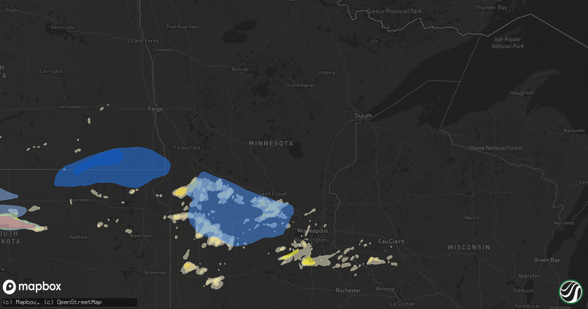
Hail Map in Minnesota on August 23, 2021
Get this storm
August 23 map
$229
one time, instant access
Download today. No call, no setup
Keep the $229
Bought the map and want the full workflow? Apply the entire $229 to a subscription within 7 days. None of it is wasted.
Every map, not just this one
This buys you this map. Subscription and you get every map we run, in the markets you choose from a few cities to whole states to nationwide. Plus real-time alerts the moment a storm fires.
Contact data
Name, contact info, occupancy, even credit band for addresses in the footprint. You go from where it hit to who to call.
Become the source they trust
Unlimited branding weather history reports on demand. You already have the documented answer ready for the property owner, and you are the one who showed up with it.
Property data and RoofTrace estimates
Pull up any address you have got, its value and the exact code rules for that jurisdiction, straight from One Click Code. Then RoofTrace estimates the squares, pitch, and roof value, priced the way you price.
Storm reports in Minnesota
Minnesota
| Date | Description |
|---|---|
| 08/23/20215:45 AM CDT | A tree was partially blocking hwy 7 on the west side of hutchinson. |
| 08/23/20215:10 AM CDT | Numerous large tree branches downed. |
| 08/23/20214:50 AM CDT | Sheet metal roofing blown off large shed. |
| 08/23/20214:35 AM CDT | Scattered damage from near this location north to county rd 11. Corn flattened... Shed lifted and set back down... Metal roof peeled off shed and large trees down. |
| 08/23/20214:30 AM CDT | Damage to roofing and trees at local business. |
| 08/23/20214:30 AM CDT | Corrects previous tstm wnd gst report from 3 e glenwood. Measured at kghw. |
| 08/23/20214:30 AM CDT | 3 roads are blocked by downed trees in glenwood. |
| 08/23/20214:00 AM CDT | A local report indicates 1.00 inch wind near LONSDALE |
All States Impacted by Hail Map on August 23, 2021
Cities Impacted by Hail Map on August 23, 2021
- Northfield, MN
- Farwell, MN
- Kensington, MN
- Forbes, ND
- Leola, SD
- Ellsworth, WI
- Bay City, WI
- Saint Francis, SD
- Wellsville, MO
- Bayard, NM
- Hanover, NM
- Frankford, MO
- Max, ND
- Sawyer, ND
- Valley City, ND
- Benson, MN
- Milan, MN
- Montevideo, MN
- Clara City, MN
- Appleton, MN
- Danvers, MN
- Clarkfield, MN
- Maynard, MN
- Boyd, MN
- Glenwood, MN
- Lowry, MN
- Starbuck, MN
- Sauk Centre, MN
- Villard, MN
- Brooten, MN
- Revere, MN
- Walnut Grove, MN
- Alton, MO
- Couch, MO
- Douglas, AZ
- Lamberton, MN
- Westbrook, MN
- Thedford, NE
- White River, SD
- Dupree, SD
- Saint Charles, MO
- Golden Eagle, IL
- Brussels, IL
- Cosmos, MN
- Litchfield, MN
- Festus, MO
- Fults, IL
- Bloomsdale, MO
- Valmeyer, IL
- Saint Cloud, MN
- Kimball, MN
- Renville, MN
- Sacred Heart, MN
- Lakeside, NE
- Valentine, NE
- Johnstown, NE
- Gaylord, MN
- Capitan, NM
- Hondo, NM
- Turton, SD
- Conde, SD
- Alexandria, MN
- Parshall, ND
- Granite Falls, MN
- Elfrida, AZ
- Harrisonville, PA
- Breezewood, PA
- Crystal Spring, PA
- Eau Claire, WI
- Goodhue, MN
- Murdock, MN
- Eagle Butte, SD
- Hoven, SD
- Gettysburg, SD
- Lebanon, SD
- Olivia, MN
- Danube, MN
- Tombstone, AZ
- Timber Lake, SD
- Ellsworth, NE
- Belgrade, MN
- Sterling, IL
- Dixon, IL
- Polo, IL
- Elko New Market, MN
- Montgomery, MN
- Lonsdale, MN
- Webster, MN
- Dundas, MN
- Faribault, MN
- McIntosh, SD
- Garretson, SD
- Henderson, MN
- Green Isle, MN
- Lordsburg, NM
- Drake, ND
- Eden Prairie, MN
- Minnetonka, MN
- Hanley Falls, MN
- Magdalena, NM
- Holloway, MN
- Hancock, MN
- Shipman, IL
- Brighton, IL
- Le Sueur, MN
- Saint Louis, MO
- Meadow, SD
- Morris, MN
- Chokio, MN
- Dumont, MN
- Saint Paul, MN
- Madison, MN
- Canby, MN
- Burnsville, MN
- Middletown, MO
- Rushville, IL
- Virginia, IL
- Arenzville, IL
- Frederick, IL
- Beardstown, IL
- Ashland, IL
- Alexander, IL
- Jacksonville, IL
- Mount Sterling, IL
- Centerville, MO
- Potosi, MO
- Flasher, ND
- Solen, ND
- Cold Spring, MN
- Sainte Genevieve, MO
- Farmington, MO
- Saint Mary, MO
- Lake City, MN
- Frontenac, MN
- Red Wing, MN
- Tolstoy, SD
- Becker, MN
- Monticello, MN
- Clear Lake, MN
- Alma, WI
- Mondovi, WI
- Nelson, WI
- Durand, WI
- Eleva, WI
- McNeal, AZ
- Glencross, SD
- McLaughlin, SD
- Isabel, SD
- Bingham, NE
- Saint Peters, MO
- Fullerton, ND
- Ellendale, ND
- Watauga, SD
- Wakpala, SD
- Vienna, MO
- Belle, MO
- Karlsruhe, ND
- Grove City, MN
- Atwater, MN
- Chadwick, IL
- Covington, LA
- Ponchatoula, LA
- New Salem, ND
- Sisseton, SD
- Melrose, MN
- Paynesville, MN
- New London, MN
- Belleville, IL
- Shakopee, MN
- Belle Plaine, MN
- South Haven, MN
- Clearwater, MN
- Maple Lake, MN
- Annandale, MN
- Prior Lake, MN
- New Prague, MN
- Jordan, MN
- Minneota, MN
- Taunton, MN
- Porter, MN
- Ivanhoe, MN
- Pepin, WI
- Ellington, MO
- Seneca, SD
- Delano, MN
- Alberta, MN
- Graceville, MN
- Deming, NM
- Whitehorse, SD
- Elmwood, WI
- Odessa, MN
- Bellingham, MN
- Hopkins, MN
- Minneapolis, MN
- Cyrus, MN
- Selfridge, ND
- Watson, MN
- Lehr, ND
- Tyler, MN
- Ghent, MN
- Arco, MN
- Marshall, MN
- Russell, MN
- Lynd, MN
- Rugby, ND
- Clark, SD
- Raymond, SD
- Milbank, SD
- Towner, ND
- Savage, MN
- Florence, SD
- Henry, SD
- Harmon, IL
- Rock Falls, IL
- Raleigh, ND
- Eden, SD
- Willernie, MN
- Java, SD
- Selby, SD
- Lucan, MN
- Riverton, NE
- Bonne Terre, MO
- French Village, MO
- Bowling Green, MO
- Curryville, MO
- Cokato, MN
- Roscoe, MN
- Buffalo, MN
- Darwin, MN
- Watkins, MN
- Dassel, MN
- Richmond, MN
- Rockville, MN
- Eden Valley, MN
- Randolph, MN
- Cannon Falls, MN
- Birch Tree, MO
- Crystal City, MO
- Tracy, MN
- Currie, MN
- Higden, AR
- Lake Lillian, MN
- Carson, ND
- Ipswich, SD
- Aberdeen, SD
- Groton, SD
- Independence, WI
- Berlin, ND
- Balaton, MN
- Melbourne, AR
- Mount Pleasant, AR
- Killdeer, ND
- Roseglen, ND
- Webster, SD
- Madisonville, LA
- Wabasso, MN
- Vesta, MN
- Beardsley, MN
- Andover, MN
- Cedar, MN
- Wyoming, MN
- Mountain View, AR
- Plaza, ND
- Ryder, ND
- Correll, MN
- Millville, MN
- Storden, MN
- De Soto, MO
- Montrose, MN
- Waverly, MN
- Hamburg, MN
- Milroy, MN
- Garvin, MN
- Norwood Young America, MN
- Bellflower, MO
- Jonesburg, MO
- High Hill, MO
- Shields, ND
- East Saint Louis, IL
- Fairview Heights, IL
- Collinsville, IL
- Caseyville, IL
- Vandalia, MO
- Balfour, ND
- Hector, MN
- Okaton, SD
- Montgomery City, MO
- Warrenton, MO
- Herman, MN
- Hoffman, MN
- Donnelly, MN
- Sunburg, MN
- Mandaree, ND
- Linton, ND
- Hazelton, ND
- Menomonie, WI
- Eau Galle, WI
- Milledgeville, IL
- Faulkton, SD
- Baton Rouge, LA
- Prairieville, LA
- Saint Gabriel, LA
- Oriska, ND
- Lakeville, MN
- Union, MO
- Strum, WI
- Whitehall, WI
- Big Stone City, SD
- Hager City, WI
- Las Cruces, NM
- Portage Des Sioux, MO
- Piasa, IL
- Minot, ND
- Welch, MN
- Madison, IL
- Venice, IL
- Granite City, IL
- Rincon, NM
- Litchville, ND
- Chaska, MN
- Dawson, MN
- Raymond, MN
- Bald Knob, AR
- Maple Plain, MN
- Wright City, MO
- Truesdale, MO
- Cave City, AR
- Cologne, MN
- Hastings, MN
- Carver, MN
- Saint Peter, MN
- Farmington, MN
- Dennison, MN
- Hampton, MN
- Le Center, MN
- Spring Valley, WI
- Murdo, SD
- Evening Shade, AR
- Anoka, MN
- Mandan, ND
- Trail City, SD
- Bunker, MO
- Loretto, MN
- Rockford, MN
- Howard Lake, MN
- Pleasant Plains, IL
- New Berlin, IL
- Redwood Falls, MN
- Wishek, ND
- Judsonia, AR
- Winsted, MN
- Bowdle, SD
- Roscoe, SD
- Onaka, SD
- Arlington, MN
- Blomkest, MN
- Prinsburg, MN
- Echo, MN
- Andover, SD
- Bradley, SD
- Stockholm, WI
- Maiden Rock, WI
- Bird Island, MN
- Robert, LA
- Makoti, ND
- Mountainair, NM
- Berger, MO
- Ridgeview, SD
- Saint Michael, MN
- Clontarf, MN
- Elrosa, MN
- Hutchinson, MN
- Lester Prairie, MN
- Saint Martin, MN
- Mayer, MN
- Spicer, MN
- Willmar, MN
- Elk River, MN
- New Germany, MN
- Watertown, MN
- Freeport, MN
- Evansville, MN
- Silver Lake, MN
- Barrett, MN
- Big Lake, MN
- Avon, MN
- Albany, MN
- Stewart, MN
- Kerkhoven, MN
- Saint Joseph, MN
- Kandiyohi, MN
- Albertville, MN
- Buffalo Lake, MN
- Osakis, MN
- Brandon, MN
- Glencoe, MN
- Pennock, MN
- Lantry, SD
- Little Eagle, SD
- Glenham, SD
- Mound City, SD
- Mobridge, SD
- Akaska, SD
- Hankinson, ND
- Fairmount, ND
- Stirum, ND
- Claire City, SD
- Westport, SD
- Columbia, SD
- Oakes, ND
- Rosholt, SD
- Wheaton, MN
- Britton, SD
- Gwinner, ND
- Tintah, MN
- Houghton, SD
- Cogswell, ND
- Lake City, SD
- Barney, ND
- Havana, ND
- Amherst, SD
- Veblen, SD
- New Effington, SD
- Mantador, ND
- Forman, ND
- Wyndmere, ND
- Milnor, ND
- Barnard, SD
- Cayuga, ND
- Mooreton, ND
- Frederick, SD
- Campbell, MN
- Claremont, SD
- Wahpeton, ND
- Hecla, SD
- Lidgerwood, ND
- Rutland, ND
- Augusta, MO
- Marlborough, MA
- Bolton, MA


