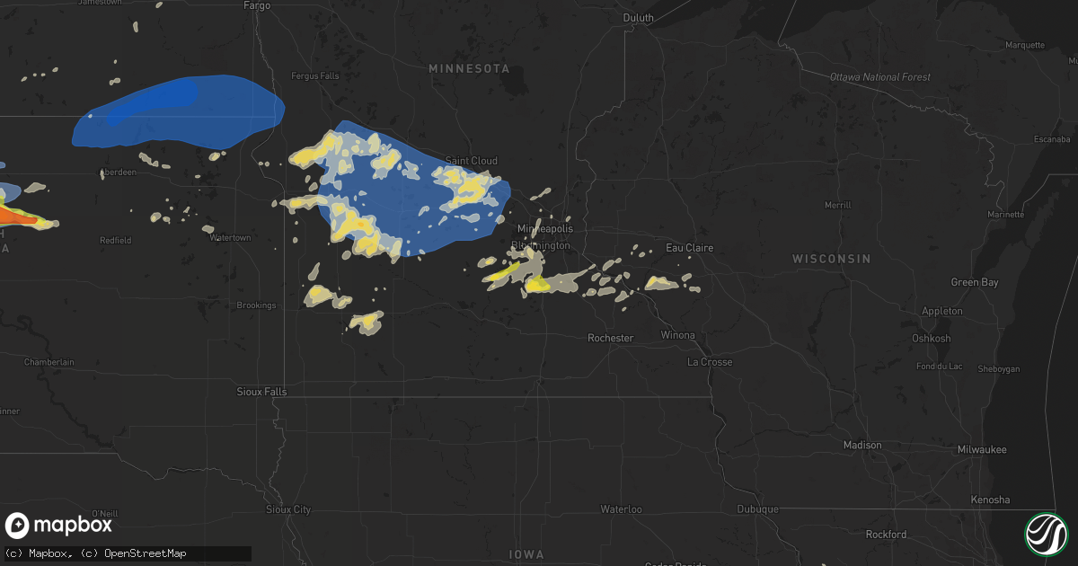
Hail Map on August 23, 2021
Get this storm
August 23 map
$229
one time, instant access
Download today. No call, no setup
Keep the $229
Bought the map and want the full workflow? Apply the entire $229 to a subscription within 7 days. None of it is wasted.
Every map, not just this one
This buys you this map. Subscription and you get every map we run, in the markets you choose from a few cities to whole states to nationwide. Plus real-time alerts the moment a storm fires.
Contact data
Name, contact info, occupancy, even credit band for addresses in the footprint. You go from where it hit to who to call.
Become the source they trust
Unlimited branding weather history reports on demand. You already have the documented answer ready for the property owner, and you are the one who showed up with it.
Property data and RoofTrace estimates
Pull up any address you have got, its value and the exact code rules for that jurisdiction, straight from One Click Code. Then RoofTrace estimates the squares, pitch, and roof value, priced the way you price.
States Impacted by Hail Map on August 23, 2021
Storm reports
Minnesota
| Date | Description |
|---|---|
| 08/23/20215:45 AM CDT | A tree was partially blocking hwy 7 on the west side of hutchinson. |
| 08/23/20215:10 AM CDT | Numerous large tree branches downed. |
| 08/23/20214:50 AM CDT | Sheet metal roofing blown off large shed. |
| 08/23/20214:35 AM CDT | Scattered damage from near this location north to county rd 11. Corn flattened... Shed lifted and set back down... Metal roof peeled off shed and large trees down. |
| 08/23/20214:30 AM CDT | Damage to roofing and trees at local business. |
| 08/23/20214:30 AM CDT | Corrects previous tstm wnd gst report from 3 e glenwood. Measured at kghw. |
| 08/23/20214:30 AM CDT | 3 roads are blocked by downed trees in glenwood. |
| 08/23/20214:00 AM CDT | A local report indicates 1.00 inch wind near LONSDALE |
South Dakota
| Date | Description |
|---|---|
| 08/23/20216:55 PM CDT | A local report indicates 1.00 inch wind near 12 SSW SOUTH EAGLE BUTT |
| 08/23/20216:55 PM CDT | A local report indicates 80 MPH wind near 14 SSE DUPREE |
| 08/23/20216:55 PM CDT | A local report indicates 60 MPH wind near 12 WSW SOUTH EAGLE BUTT |
| 08/23/20215:56 PM CDT | A local report indicates 84 MPH wind near 27 WNW CASTLE ROCK |
| 08/23/20215:43 PM CDT | A local report indicates 84 MPH wind near 27 WNW CASTLE ROCK |
| 08/23/20215:30 PM CDT | A local report indicates 60 MPH wind near 5 NW WHITE RIVER |
| 08/23/20215:25 PM CDT | A local report indicates 1.00 inch wind near 5 NW WHITE RIVER |
| 08/23/20215:15 PM CDT | A local report indicates 1.00 inch wind near WESTOVER |
| 08/23/20216:51 AM CDT | At 1151 PM CDT, a severe thunderstorm was located near Lebanon, or 12 miles northeast of Gettysburg, moving east at 45 mph. HAZARD...Two inch hail and 60 mph wind gusts. SOURCE...Radar indicated. IMPACT...People and animals outdoors will be injured. Expect hail damage to roofs, siding, windows, and vehicles. Expect wind damage to roofs, siding, and trees. This severe thunderstorm will be near... Tolstoy around 1200 AM CDT. Seneca around 1205 AM CDT. Onaka around 1210 AM CDT.Other locations in the path of this severe thunderstorm includeBrentwood Colony, Burkmere, Norbeck, Faulkton, Cresbard and Devoe. |
| 08/23/20216:33 AM CDT | Mesonet station 55 summit |
| 08/23/20215:56 AM CDT | At 1056 PM CDT/956 PM MDT/, a severe thunderstorm was located 8 miles north of Swiftbird Day School, or 23 miles south of Mobridge, moving east at 35 mph. HAZARD...Ping pong ball size hail and 60 mph wind gusts. SOURCE...Radar indicated. IMPACT...People and animals outdoors will be injured. Expect hail damage to roofs, siding, windows, and vehicles. Expect wind damage to roofs, siding, and trees. This severe thunderstorm will be near... Swan Creek Rec Area around 1115 PM CDT.Other locations in the path of this severe thunderstorm includeAkaska, Lowry and Hoven. |
| 08/23/20215:37 AM CDT | Mesonet station 45 andover |
| 08/23/20215:17 AM CDT | At 1017 PM CDT/917 PM MDT/, a severe thunderstorm was located near Parade, or 11 miles northeast of Eagle Butte, moving east at 35 mph. HAZARD...60 mph wind gusts and quarter size hail. SOURCE...Radar indicated. IMPACT...Hail damage to vehicles is expected. Expect wind damage to roofs, siding, and trees. This severe thunderstorm will be near... Ridgeview around 935 PM MDT.Other locations in the path of this severe thunderstorm includeTiospaye Topa School, Laplant and Swiftbird Day School. |
| 08/23/20215:01 AM CDT | At 1001 PM CDT/901 PM MDT/, a severe thunderstorm was located near Glencross, or 20 miles west of Mobridge, moving east at 45 mph. HAZARD...60 mph wind gusts and quarter size hail. SOURCE...Radar indicated. IMPACT...Hail damage to vehicles is expected. Expect wind damage to roofs, siding, and trees. This severe thunderstorm will be near... Trail City around 910 PM MDT.Other locations in the path of this severe thunderstorm include GrandRiver Casino, Indian Memorial Rec Area, Mobridge, Revheim Bay RecArea, Indian Creek Rec Area and Glenham. |
| 08/23/20213:13 AM CDT | At 813 PM MDT, a severe thunderstorm was located 8 miles southeast of Klein Ranch, or 26 miles southwest of Mclaughlin, moving east at 45 mph. HAZARD...60 mph wind gusts and quarter size hail. SOURCE...Radar indicated. IMPACT...Hail damage to vehicles is expected. Expect wind damage to roofs, siding, and trees. Locations impacted include... Little Eagle and Mahto. |
| 08/23/20212:42 AM CDT | At 742 PM MDT, a severe thunderstorm was located near Shambo Ranch, or 32 miles north of Dupree, moving northeast at 40 mph. HAZARD...60 mph wind gusts and quarter size hail. SOURCE...Radar indicated. IMPACT...Hail damage to vehicles is expected. Expect wind damage to roofs, siding, and trees. Locations impacted include... Black Horse and Mcintosh. |
| 08/23/20211:12 AM CDT | At 611 PM MDT, a severe thunderstorm was located near Lantry, moving northeast at 40 mph. HAZARD...60 mph wind gusts and quarter size hail. SOURCE...Radar indicated. IMPACT...Hail damage to vehicles is expected. Expect wind damage to roofs, siding, and trees. This severe thunderstorm will be near... Eagle Butte around 615 PM MDT. Green Grass around 630 PM MDT. |
| 08/23/202112:55 AM CDT | At 555 PM CDT, a severe thunderstorm was located 4 miles southwest of Intersection of Highway 83 and White River, or 5 miles north of White River, moving east at 10 mph. HAZARD...Ping pong ball size hail and 60 mph wind gusts. SOURCE...Radar indicated. IMPACT...People and animals outdoors will be injured. Expect hail damage to roofs, siding, windows, and vehicles. Expect wind damage to roofs, siding, and trees. This severe thunderstorm will remain over mainly rural areas of central Mellette County. |
| 08/23/202112:42 AM CDT | At 541 PM MDT, a severe thunderstorm was located 7 miles east of Intersection of Cherry Creek and Sunnybrook Roads, or 11 miles south of Lantry, moving northeast at 40 mph. HAZARD...60 mph wind gusts and quarter size hail. SOURCE...Radar indicated. IMPACT...Hail damage to vehicles is expected. Expect wind damage to roofs, siding, and trees. This severe thunderstorm will be near... Intersection of Highway 63 and BIA Road 8 around 550 PM MDT. South Eagle Butte around 600 PM MDT. |
| 08/23/202112:33 AM CDT | Mesonet station 49 frederick |
| 08/23/202112:28 AM CDT | Mesonet station 215 jct sd47/sd26 |
| 08/23/202112:28 AM CDT | A local report indicates 1.00 inch wind near 3 W BURKMERE |
| 08/23/202112:27 AM CDT | A local report indicates 58 MPH wind near 9 E SPRING CREEK COLONY |
| 08/23/202112:21 AM CDT | At 521 PM CDT, a severe thunderstorm was located near Rosebud, or 12 miles west of Mission, moving east at 20 mph. HAZARD...60 mph wind gusts and quarter size hail. SOURCE...Radar indicated. IMPACT...Hail damage to vehicles is expected. Expect wind damage to roofs, siding, and trees. This severe thunderstorm will be near... Rosebud and Soldier Creek around 525 PM CDT. Fairgrounds Housing around 530 PM CDT. Ring Thunder around 535 PM CDT.Other locations in the path of this severe thunderstorm includeMission, Antelope and Haystack Butte. |
| 08/23/202112:15 AM CDT | At 515 PM MDT, a severe thunderstorm was located 4 miles north of Milesville, or 32 miles north of Philip, moving northeast at 20 mph. HAZARD...60 mph wind gusts and quarter size hail. SOURCE...Radar indicated. IMPACT...Hail damage to vehicles is expected. Expect wind damage to roofs, siding, and trees. Locations impacted include... Cherry Creek. |
| 08/23/202112:07 AM CDT | At 506 PM CDT, a severe thunderstorm was located over Intersection of Highway 83 and White River, or 9 miles north of White River, moving northeast at 30 mph. HAZARD...60 mph wind gusts and quarter size hail. SOURCE...Radar indicated. IMPACT...Hail damage to vehicles is expected. Expect wind damage to roofs, siding, and trees. This severe thunderstorm will be near... Westover around 515 PM CDT.Other locations in the path of this severe thunderstorm includeDraper. |
| 08/23/202112:01 AM CDT | At 501 PM CDT, a severe thunderstorm was located 3 miles north of Swift Bear, or 3 miles north of White River, moving east at 30 mph. HAZARD...60 mph wind gusts and quarter size hail. SOURCE...Radar indicated. IMPACT...Hail damage to vehicles is expected. Expect wind damage to roofs, siding, and trees. This severe thunderstorm will remain over mainly rural areas of central Mellette County. |
| 08/22/202111:45 PM CDT | 60 plus mph wind gust estimated. Relayed via social media. |
| 08/22/202111:43 PM CDT | Mesonet station 184 eureka |
| 08/22/202111:24 PM CDT | Time estimated based on radar. |
| 08/22/202111:13 PM CDT | At 413 PM CDT, a severe thunderstorm was located near Okaton, or 8 miles southwest of Murdo, moving northeast at 25 mph. HAZARD...60 mph wind gusts and quarter size hail. SOURCE...Radar indicated. IMPACT...Hail damage to vehicles is expected. Expect wind damage to roofs, siding, and trees. Locations impacted include... Murdo and Draper. |
| 08/22/202110:48 PM CDT | Mesonet station 50 herreid |
| 08/22/202110:08 PM CDT | Mesonet station 178 trail city |
| 08/22/202110:06 PM CDT | Grand river raws mesonet. |
| 08/22/20219:52 PM CDT | A local report indicates 60 MPH wind near 6 SSW LITTLE EAGLE |
| 08/22/20219:47 PM CDT | Social media report. |
| 08/22/20219:46 PM CDT | Mesonet station 293 timber lake |
| 08/22/20219:45 PM CDT | At 245 PM MDT/345 PM CDT/, severe thunderstorms were located along a line extending from 10 miles southwest of Okaton to 2 miles northeast of Corn Creek, moving northeast at 20 mph. HAZARD...60 mph wind gusts and quarter size hail. SOURCE...Radar indicated. IMPACT...Hail damage to vehicles is expected. Expect wind damage to roofs, siding, and trees. These severe thunderstorms will remain over mainly rural areas of northwestern Mellette and northeastern Jackson Counties. |
| 08/22/20219:26 PM CDT | Corrects time for previous tstm wnd gst report from 11 s bullhead. Grand river raws mesonet. |
| 08/22/20219:25 PM CDT | Roof blown off barn. |
| 08/22/20219:15 PM CDT | Corrects time on previous tstm wnd dmg report from 10 s bullhead. Shingles blown of house... Rolled tin... Lots of branches off trees. |
| 08/22/20219:02 PM CDT | No lightning activity... But was associated with high-based convective clouds. |
| 08/22/20218:15 PM CDT | Shingles blown of house... Rolled tin... Lots of branches off trees. |
| 08/22/20217:19 PM CDT | Report from mping: half dollar |
| 08/22/20217:13 PM CDT | Report from mping: quarter |
Massachusetts
| Date | Description |
|---|---|
| 08/23/202112:10 PM CDT | Nws norton survey team confirmed an ef0 tornado in stow at 110 pm. This tornado caused minor damage on state highway 117 near the stow police department. The tornado kn |
| 08/23/202111:30 AM CDT | Nws norton survey team confirmed an ef0 tornado between 175 and 198 main st in bolton. This caused minor damage consisting of trees knocked down into powerline wires an |
| 08/23/202110:50 AM CDT | Large limb down on vehicle on cedar hill street. |
| 08/23/202110:45 AM CDT | Spotter was watching tornado at the time of the call. |
Missouri
| Date | Description |
|---|---|
| 08/23/20215:26 PM CDT | Trees down in st. Mary. Time estimated from radar. |
| 08/23/20215:09 PM CDT | Small tree limbs down. Time estimated from radar. |
| 08/23/20214:43 PM CDT | Measured gust of 61 mph. |
| 08/23/20213:47 PM CDT | Multiple trees down in the cool valley area... Including one uprooted and some fence damage. |
| 08/23/20213:46 PM CDT | Several large limbs down in the normandy area. |
| 08/23/20213:03 PM CDT | Trees snapped off along highway 94. Time estimated from radar. |
| 08/23/20212:31 PM CDT | Large tree limb down on power lines. Street sign blown over. |
| 08/22/202111:01 PM CDT | At 400 PM CDT, a severe thunderstorm was located over Wright City, moving east at 10 mph. HAZARD...60 mph wind gusts. SOURCE...Radar indicated. IMPACT...Expect damage to roofs, siding, and trees. Locations impacted include... Wentzville, Warrenton, Wright City, Moscow Mills, Truesdale, Innsbrook, Flint Hill and Foristell.This includes Interstate 70 in Missouri between exits 199 and 203. |
| 08/22/202110:05 PM CDT | At 304 PM CDT, a severe thunderstorm was located over Augusta, and is nearly stationary. HAZARD...60 mph wind gusts. SOURCE...Radar indicated. IMPACT...Expect damage to roofs, siding, and trees. Locations impacted include... Augusta. |
Maryland
| Date | Description |
|---|---|
| 08/23/20212:14 AM CDT | At 714 PM EDT, a severe thunderstorm was located over Green Spring, or 8 miles south of Middletown, moving southeast at 25 mph. HAZARD...60 mph wind gusts. SOURCE...Radar indicated. IMPACT...Damage to roofs, siding, trees, and power lines is possible. Locations impacted include... Dover, Middletown, Smyrna, Camden, Clayton, Cheswold, Woodside, Hartly, Rising Sun-Lebanon, Hazlettville, Delaney Corner, Dover Base Housing, Dover Speedway, Green Spring, Rising Sun, Townsend, Wyoming, Odessa, Kenton and Little Creek. |
Illinois
| Date | Description |
|---|---|
| 08/23/20214:15 PM CDT | Small tree limbs down. Time estimated from radar. |
| 08/23/20213:53 PM CDT | Large tree on a car. |
| 08/23/20213:00 PM CDT | Delayed report. Damage to outbuilding... Crop damage... Leaning power poles and damage to trailer. Relayed by sterling and dixon telegraph photographer and reporter. Ti |
| 08/23/20212:59 PM CDT | Damage to several large trees. About 100 yards east of intersection of penrose ad weldon roads. Time estimated from radar. |
| 08/23/20211:30 PM CDT | 20 power poles broken along us-67 south of beardstown. Us-67 is currently closed. Report relayed by broadcast media. Time estimated by radar. |
| 08/22/202111:23 PM CDT | At 423 PM CDT, a severe thunderstorm was located over Belleville, moving east at 10 mph. HAZARD...60 mph wind gusts. SOURCE...Radar indicated. IMPACT...Expect damage to roofs, siding, and trees. Locations impacted include... Belleville, O'Fallon, Fairview Heights, Swansea, Shiloh, Mascoutah, Lebanon, Freeburg, Caseyville, Millstadt, Scott AFB, Smithton and Fayetteville.This includes Interstate 64 in Illinois between exits 12 and 23. |
| 08/22/202110:33 PM CDT | At 332 PM CDT, a severe thunderstorm was located over Pine Lawn, and is nearly stationary. HAZARD...60 mph wind gusts. SOURCE...Radar indicated. IMPACT...Expect damage to roofs, siding, and trees. This severe thunderstorm will be near... St. Louis around 340 PM CDT.This also includes Scott Joplin Historic Site. |
| 08/22/202110:06 PM CDT | At 306 PM CDT, a severe thunderstorm was located over Dixon, moving southeast at 15 mph. HAZARD...60 mph wind gusts and nickel size hail. SOURCE...Radar indicated. IMPACT...Expect damage to roofs, siding, and trees. Locations impacted include... Dixon, Grand Detour, Woodland Shores and Woosung. Including the following interstate... I-88 between mile markers 50 and 54. |
| 08/22/20218:47 PM CDT | At 147 PM CDT, a severe thunderstorm was located near Bluff Springs, or near Virginia, moving southeast at 25 mph. HAZARD...60 mph wind gusts and penny size hail. SOURCE...Radar indicated. IMPACT...Expect damage to roofs, siding, and trees. This severe thunderstorm will be near... Virginia around 200 PM CDT.Other locations in the path of this severe thunderstorm includeLiterberry, Ashland and Alexander.This includes Interstate 72 between mile markers 71 and 79. |
| 08/22/20218:26 PM CDT | At 126 PM CDT, a severe thunderstorm was located near Beardstown, moving southeast at 25 mph. HAZARD...60 mph wind gusts and quarter size hail. SOURCE...Radar indicated. IMPACT...Hail damage to vehicles is expected. Expect wind damage to roofs, siding, and trees. This severe thunderstorm will be near... Beardstown around 135 PM CDT. Bluff Springs around 145 PM CDT.Other locations in the path of this severe thunderstorm includeArenzville and Virginia. |
| 08/22/20218:08 PM CDT | At 108 PM CDT, a severe thunderstorm was located near Rushville, moving southeast at 15 mph. HAZARD...60 mph wind gusts and quarter size hail. SOURCE...Radar indicated. IMPACT...Hail damage to vehicles is expected. Expect wind damage to roofs, siding, and trees. Locations impacted include... Beardstown. |
Wisconsin
| Date | Description |
|---|---|
| 08/23/20216:57 AM CDT | Report from mping: 3-inch tree limbs broken; power poles broken. |
| 08/23/20216:56 AM CDT | Strong winds ripped vents off the roof of an apartment complex... Causing major leaking to apartments below from the heavy rain. |
| 08/23/20216:52 AM CDT | A local report indicates 63 MPH wind near 2 S EAU CLAIRE |
North Dakota
| Date | Description |
|---|---|
| 08/23/20215:06 AM CDT | At 1006 PM CDT, a severe thunderstorm was located 7 miles northwest of Fort Yates, moving northeast at 50 mph. HAZARD...60 mph wind gusts and quarter size hail. SOURCE...Radar indicated. IMPACT...Hail damage to vehicles is expected. Expect wind damage to roofs, siding, and trees. This severe thunderstorm will be near... Fort Yates around 1010 PM CDT. Prairie Knights Resort around 1020 PM CDT. |
| 08/23/20212:15 AM CDT | Several large 3 to 5 inch diameter tree branches broken down around a farmstead. Very strong winds occurred for about 10 minutes... From 210 am through 220 am cdt. |
| 08/23/20211:59 AM CDT | Peak wind measured at an nddot rwis station. |
| 08/23/20211:56 AM CDT | Peak wind reported at an ndawn station at 10 meters. |
| 08/23/20211:02 AM CDT | Personal weather station in oakes measured 70 mph sustained wind gusting to 97 mph. |
| 08/23/202112:17 AM CDT | At 514 PM MDT, severe thunderstorms were located along a line extending from 11 miles north of Camp Crook to 5 miles north of Hoover, moving northeast at 45 mph. HAZARD...70 mph wind gusts. SOURCE...Radar indicated. IMPACT...Expect considerable tree damage. Damage is likely to mobile homes, roofs, and outbuildings. Locations impacted include... Buffalo, Bison, Ludlow, Reva, Ralph, Sorum, Date, Prairie City, Ladner, Slim Buttes, Owen Lake, South Cave Hills, Sheep Buttes, Lake Gardner, Table Mountain and North Cave Hills. |
Nebraska
| Date | Description |
|---|---|
| 08/23/20212:43 AM CDT | A local report indicates 60 MPH wind near 32 S VALENTINE |
Arizona
| Date | Description |
|---|---|
| 08/22/202111:37 PM CDT | At 437 PM MST, a severe thunderstorm was located 12 miles southeast of Solomon, or 17 miles southeast of Safford, moving northeast at 15 mph. HAZARD...60 mph wind gusts and quarter size hail. SOURCE...Radar indicated. IMPACT...Hail damage to vehicles is expected. Expect wind damage to roofs, siding, and trees. This severe thunderstorm will remain over mainly remote areas of southeastern Graham and west central Greenlee Counties. |
| 08/22/20219:43 PM CDT | At 242 PM MST, a severe thunderstorm was located near Pearce-Sunsites, moving northwest at 5 mph. HAZARD...60 mph wind gusts and quarter size hail. SOURCE...Radar indicated. IMPACT...Hail damage to vehicles is expected. Expect wind damage to roofs, siding, and trees. Locations impacted include... Pearce-Sunsites. |
| 08/22/20218:50 PM CDT | At 149 PM MST, a severe thunderstorm was located near Hereford, or near Sierra Vista, moving northeast at 5 mph. HAZARD...60 mph wind gusts and quarter size hail. SOURCE...Radar indicated. IMPACT...Hail damage to vehicles is expected. Expect wind damage to roofs, siding, and trees. Locations impacted include... Sierra Vista and Hereford. |
| 08/22/20218:19 PM CDT | At 118 PM MDT, a severe thunderstorm was located 7 miles northwest of Cloverdale, moving south at 5 mph. HAZARD...Ping pong ball size hail and 60 mph wind gusts. SOURCE...Radar indicated. IMPACT...People and animals outdoors will be injured. Expect hail damage to roofs, siding, windows, and vehicles. Expect wind damage to roofs, siding, and trees. Locations impacted include... Cloverdale, Geronimo Pass and Skeleton Canyon. |
New Mexico
| Date | Description |
|---|---|
| 08/22/202111:40 PM CDT | At 439 PM MDT, a severe thunderstorm was located 6 miles north of Nutt, moving northeast at 5 mph. HAZARD...60 mph wind gusts and half dollar size hail. SOURCE...Radar indicated. IMPACT...Hail damage to vehicles is expected. Expect wind damage to roofs, siding, and trees. This severe thunderstorm will remain over mainly rural areas of south central Sierra County. |
| 08/22/202111:17 PM CDT | At 417 PM MDT, a severe thunderstorm was located 6 miles southeast of Rincon, moving east at 5 mph. HAZARD...60 mph wind gusts and half dollar size hail. SOURCE...Radar indicated. IMPACT...Hail damage to vehicles is expected. Expect wind damage to roofs, siding, and trees. Locations impacted include... Rincon, Radium Springs and Portions of Jornada Experimental Range. This includes Interstate 25 in New Mexico between mile markers 19 and34. |
| 08/22/202111:03 PM CDT | At 403 PM MDT, a severe thunderstorm was located 6 miles southwest of Faywood, moving northeast at 5 mph. HAZARD...60 mph wind gusts and quarter size hail. SOURCE...Radar indicated. IMPACT...Hail damage to vehicles is expected. Expect wind damage to roofs, siding, and trees. Locations impacted include... Faywood and City Of Rocks State Park. |
| 08/22/202110:35 PM CDT | At 334 PM MDT, a severe thunderstorm was located 11 miles southeast of White Signal, and is nearly stationary. HAZARD...60 mph wind gusts and half dollar size hail. SOURCE...Radar indicated. IMPACT...Hail damage to vehicles is expected. Expect wind damage to roofs, siding, and trees. This severe thunderstorm will remain over mainly rural areas of central Grant and northwestern Luna Counties. |
| 08/22/202110:22 PM CDT | At 321 PM MDT, a severe thunderstorm was located 7 miles east of Lordsburg, moving northeast at 5 mph. HAZARD...60 mph wind gusts and half dollar size hail. SOURCE...Radar indicated. IMPACT...Hail damage to vehicles is expected. Expect wind damage to roofs, siding, and trees. Locations impacted include... Lordsburg.This includes Interstate 10 in New Mexico between mile markers 24 and34. |
| 08/22/20218:59 PM CDT | At 159 PM MDT, a severe thunderstorm was located near San Patricio, or 23 miles northeast of Ruidoso, moving southwest at 10 mph. HAZARD...Ping pong ball size hail and 60 mph wind gusts. SOURCE...Radar indicated. IMPACT...People and animals outdoors will be injured. Expect hail damage to roofs, siding, windows, and vehicles. Expect wind damage to roofs, siding, and trees. Locations impacted include... Lincoln, Hondo, Tinnie, Glencoe, Lincoln State Monument and San Patricio.This includes Highway 380 between Mile Markers 96 and 107. |
New Jersey
| Date | Description |
|---|---|
| 08/22/202110:15 PM CDT | At 314 PM EDT, a severe thunderstorm was located over Brookville, or 13 miles south of Toms River, moving southeast at 30 mph. HAZARD...60 mph wind gusts. SOURCE...Radar indicated. IMPACT...Damage to roofs, siding, trees, and power lines is possible. Locations impacted include... Barnegat, Beachwood, Surf City, Brookville, Beach Haven West, Manahawkin, Ocean Acres, Waretown and Holiday Heights.This includes Garden State Parkway between mile markers 64 and 79. |
Florida
| Date | Description |
|---|---|
| 08/23/20211:23 PM CDT | Delayed report of tree down along i-95 southbound at mile marker 377. |
| 08/23/20211:00 PM CDT | Delayed report of tree down at old dixie hwy and bethel church rd. Radar estimated time. |
| 08/23/20211:00 PM CDT | Delayed report of power line down at 13941 new kings rd. |
| 08/23/202112:51 AM CDT | At 551 PM EDT, a severe thunderstorm was located 11 miles northeast of Four Seasons Estates, or 14 miles northeast of Treasure Island, moving north at 15 mph. HAZARD...60 mph wind gusts and penny size hail. SOURCE...Radar indicated. IMPACT...Expect damage to roofs, siding, and trees. This severe thunderstorm will remain over mainly rural areas of northwestern St. Lucie and east central Okeechobee Counties. |
| 08/22/20218:39 PM CDT | At 139 PM EDT, a severe thunderstorm was located near Bryceville, or 10 miles southwest of Callahan, moving east at 35 mph. HAZARD...60 mph wind gusts. SOURCE...Radar indicated. IMPACT...Expect damage to roofs, siding, and trees. Locations impacted include... Jacksonville, Hilliard, Callahan, Jacksonville International Arpt, Cisco Gardens, Nassau Village-Ratliff, Ratliff, St. George, Bryceville and Whitehouse Air Field. |
Cities Impacted by Hail Map on August 23, 2021
- Northfield, MN
- Farwell, MN
- Kensington, MN
- Forbes, ND
- Leola, SD
- Ellsworth, WI
- Bay City, WI
- Saint Francis, SD
- Wellsville, MO
- Bayard, NM
- Hanover, NM
- Frankford, MO
- Max, ND
- Sawyer, ND
- Valley City, ND
- Benson, MN
- Milan, MN
- Montevideo, MN
- Clara City, MN
- Appleton, MN
- Danvers, MN
- Clarkfield, MN
- Maynard, MN
- Boyd, MN
- Glenwood, MN
- Lowry, MN
- Starbuck, MN
- Sauk Centre, MN
- Villard, MN
- Brooten, MN
- Revere, MN
- Walnut Grove, MN
- Alton, MO
- Couch, MO
- Douglas, AZ
- Lamberton, MN
- Westbrook, MN
- Thedford, NE
- White River, SD
- Dupree, SD
- Saint Charles, MO
- Golden Eagle, IL
- Brussels, IL
- Cosmos, MN
- Litchfield, MN
- Festus, MO
- Fults, IL
- Bloomsdale, MO
- Valmeyer, IL
- Saint Cloud, MN
- Kimball, MN
- Renville, MN
- Sacred Heart, MN
- Lakeside, NE
- Valentine, NE
- Johnstown, NE
- Gaylord, MN
- Capitan, NM
- Hondo, NM
- Turton, SD
- Conde, SD
- Alexandria, MN
- Parshall, ND
- Granite Falls, MN
- Elfrida, AZ
- Harrisonville, PA
- Breezewood, PA
- Crystal Spring, PA
- Eau Claire, WI
- Goodhue, MN
- Murdock, MN
- Eagle Butte, SD
- Hoven, SD
- Gettysburg, SD
- Lebanon, SD
- Olivia, MN
- Danube, MN
- Tombstone, AZ
- Timber Lake, SD
- Ellsworth, NE
- Belgrade, MN
- Sterling, IL
- Dixon, IL
- Polo, IL
- Elko New Market, MN
- Montgomery, MN
- Lonsdale, MN
- Webster, MN
- Dundas, MN
- Faribault, MN
- McIntosh, SD
- Garretson, SD
- Henderson, MN
- Green Isle, MN
- Lordsburg, NM
- Drake, ND
- Eden Prairie, MN
- Minnetonka, MN
- Hanley Falls, MN
- Magdalena, NM
- Holloway, MN
- Hancock, MN
- Shipman, IL
- Brighton, IL
- Le Sueur, MN
- Saint Louis, MO
- Meadow, SD
- Morris, MN
- Chokio, MN
- Dumont, MN
- Saint Paul, MN
- Madison, MN
- Canby, MN
- Burnsville, MN
- Middletown, MO
- Rushville, IL
- Virginia, IL
- Arenzville, IL
- Frederick, IL
- Beardstown, IL
- Ashland, IL
- Alexander, IL
- Jacksonville, IL
- Mount Sterling, IL
- Centerville, MO
- Potosi, MO
- Flasher, ND
- Solen, ND
- Cold Spring, MN
- Sainte Genevieve, MO
- Farmington, MO
- Saint Mary, MO
- Lake City, MN
- Frontenac, MN
- Red Wing, MN
- Tolstoy, SD
- Becker, MN
- Monticello, MN
- Clear Lake, MN
- Alma, WI
- Mondovi, WI
- Nelson, WI
- Durand, WI
- Eleva, WI
- McNeal, AZ
- Glencross, SD
- McLaughlin, SD
- Isabel, SD
- Bingham, NE
- Saint Peters, MO
- Fullerton, ND
- Ellendale, ND
- Watauga, SD
- Wakpala, SD
- Vienna, MO
- Belle, MO
- Karlsruhe, ND
- Grove City, MN
- Atwater, MN
- Chadwick, IL
- Covington, LA
- Ponchatoula, LA
- New Salem, ND
- Sisseton, SD
- Melrose, MN
- Paynesville, MN
- New London, MN
- Belleville, IL
- Shakopee, MN
- Belle Plaine, MN
- South Haven, MN
- Clearwater, MN
- Maple Lake, MN
- Annandale, MN
- Prior Lake, MN
- New Prague, MN
- Jordan, MN
- Minneota, MN
- Taunton, MN
- Porter, MN
- Ivanhoe, MN
- Pepin, WI
- Ellington, MO
- Seneca, SD
- Delano, MN
- Alberta, MN
- Graceville, MN
- Deming, NM
- Whitehorse, SD
- Elmwood, WI
- Odessa, MN
- Bellingham, MN
- Hopkins, MN
- Minneapolis, MN
- Cyrus, MN
- Selfridge, ND
- Watson, MN
- Lehr, ND
- Tyler, MN
- Ghent, MN
- Arco, MN
- Marshall, MN
- Russell, MN
- Lynd, MN
- Rugby, ND
- Clark, SD
- Raymond, SD
- Milbank, SD
- Towner, ND
- Savage, MN
- Florence, SD
- Henry, SD
- Harmon, IL
- Rock Falls, IL
- Raleigh, ND
- Eden, SD
- Willernie, MN
- Java, SD
- Selby, SD
- Lucan, MN
- Riverton, NE
- Bonne Terre, MO
- French Village, MO
- Bowling Green, MO
- Curryville, MO
- Cokato, MN
- Roscoe, MN
- Buffalo, MN
- Darwin, MN
- Watkins, MN
- Dassel, MN
- Richmond, MN
- Rockville, MN
- Eden Valley, MN
- Randolph, MN
- Cannon Falls, MN
- Birch Tree, MO
- Crystal City, MO
- Tracy, MN
- Currie, MN
- Higden, AR
- Lake Lillian, MN
- Carson, ND
- Ipswich, SD
- Aberdeen, SD
- Groton, SD
- Independence, WI
- Berlin, ND
- Balaton, MN
- Melbourne, AR
- Mount Pleasant, AR
- Killdeer, ND
- Roseglen, ND
- Webster, SD
- Madisonville, LA
- Wabasso, MN
- Vesta, MN
- Beardsley, MN
- Andover, MN
- Cedar, MN
- Wyoming, MN
- Mountain View, AR
- Plaza, ND
- Ryder, ND
- Correll, MN
- Millville, MN
- Storden, MN
- De Soto, MO
- Montrose, MN
- Waverly, MN
- Hamburg, MN
- Milroy, MN
- Garvin, MN
- Norwood Young America, MN
- Bellflower, MO
- Jonesburg, MO
- High Hill, MO
- Shields, ND
- East Saint Louis, IL
- Fairview Heights, IL
- Collinsville, IL
- Caseyville, IL
- Vandalia, MO
- Balfour, ND
- Hector, MN
- Okaton, SD
- Montgomery City, MO
- Warrenton, MO
- Herman, MN
- Hoffman, MN
- Donnelly, MN
- Sunburg, MN
- Mandaree, ND
- Linton, ND
- Hazelton, ND
- Menomonie, WI
- Eau Galle, WI
- Milledgeville, IL
- Faulkton, SD
- Baton Rouge, LA
- Prairieville, LA
- Saint Gabriel, LA
- Oriska, ND
- Lakeville, MN
- Union, MO
- Strum, WI
- Whitehall, WI
- Big Stone City, SD
- Hager City, WI
- Las Cruces, NM
- Portage Des Sioux, MO
- Piasa, IL
- Minot, ND
- Welch, MN
- Madison, IL
- Venice, IL
- Granite City, IL
- Rincon, NM
- Litchville, ND
- Chaska, MN
- Dawson, MN
- Raymond, MN
- Bald Knob, AR
- Maple Plain, MN
- Wright City, MO
- Truesdale, MO
- Cave City, AR
- Cologne, MN
- Hastings, MN
- Carver, MN
- Saint Peter, MN
- Farmington, MN
- Dennison, MN
- Hampton, MN
- Le Center, MN
- Spring Valley, WI
- Murdo, SD
- Evening Shade, AR
- Anoka, MN
- Mandan, ND
- Trail City, SD
- Bunker, MO
- Loretto, MN
- Rockford, MN
- Howard Lake, MN
- Pleasant Plains, IL
- New Berlin, IL
- Redwood Falls, MN
- Wishek, ND
- Judsonia, AR
- Winsted, MN
- Bowdle, SD
- Roscoe, SD
- Onaka, SD
- Arlington, MN
- Blomkest, MN
- Prinsburg, MN
- Echo, MN
- Andover, SD
- Bradley, SD
- Stockholm, WI
- Maiden Rock, WI
- Bird Island, MN
- Robert, LA
- Makoti, ND
- Mountainair, NM
- Berger, MO
- Ridgeview, SD
- Saint Michael, MN
- Clontarf, MN
- Elrosa, MN
- Hutchinson, MN
- Lester Prairie, MN
- Saint Martin, MN
- Mayer, MN
- Spicer, MN
- Willmar, MN
- Elk River, MN
- New Germany, MN
- Watertown, MN
- Freeport, MN
- Evansville, MN
- Silver Lake, MN
- Barrett, MN
- Big Lake, MN
- Avon, MN
- Albany, MN
- Stewart, MN
- Kerkhoven, MN
- Saint Joseph, MN
- Kandiyohi, MN
- Albertville, MN
- Buffalo Lake, MN
- Osakis, MN
- Brandon, MN
- Glencoe, MN
- Pennock, MN
- Lantry, SD
- Little Eagle, SD
- Glenham, SD
- Mound City, SD
- Mobridge, SD
- Akaska, SD
- Hankinson, ND
- Fairmount, ND
- Stirum, ND
- Claire City, SD
- Westport, SD
- Columbia, SD
- Oakes, ND
- Rosholt, SD
- Wheaton, MN
- Britton, SD
- Gwinner, ND
- Tintah, MN
- Houghton, SD
- Cogswell, ND
- Lake City, SD
- Barney, ND
- Havana, ND
- Amherst, SD
- Veblen, SD
- New Effington, SD
- Mantador, ND
- Forman, ND
- Wyndmere, ND
- Milnor, ND
- Barnard, SD
- Cayuga, ND
- Mooreton, ND
- Frederick, SD
- Campbell, MN
- Claremont, SD
- Wahpeton, ND
- Hecla, SD
- Lidgerwood, ND
- Rutland, ND
- Augusta, MO
- Marlborough, MA
- Bolton, MA