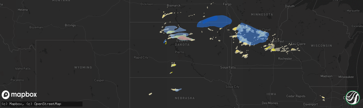
Hail Map in South Dakota on August 23, 2021
The weather event in South Dakota on August 23, 2021 includes Hail, Wind, and Tornado maps. 14 states and 440 cities were impacted and suffered possible damage. The total estimated number of properties impacted is 3,469.
Want more than just the map?
Turn this storm into a full workflow.
- Owner + property data so you know who to knock
- OnDemand branded weather history reports to win the "did we even have hail?" argument
- RoofTrace estimate so reps stop guessing numbers at the door
Bought this map? Upgrade within 7 days and we'll credit the $230. (10-15 min setup call)
Hail
Wind
Tornado
3,469
Estimated number of impacted properties by a 1.00" hail or larger1,108
Estimated number of impacted properties by a 1.75" hail or larger0
Estimated number of impacted properties by a 2.50" hail or largerStorm reports in South Dakota
South Dakota
| Date | Description |
|---|---|
| 08/23/20216:55 PM CDT | A local report indicates 1.00 inch wind near 12 SSW SOUTH EAGLE BUTT |
| 08/23/20216:55 PM CDT | A local report indicates 60 MPH wind near 12 WSW SOUTH EAGLE BUTT |
| 08/23/20216:55 PM CDT | A local report indicates 80 MPH wind near 14 SSE DUPREE |
| 08/23/20215:56 PM CDT | A local report indicates 84 MPH wind near 27 WNW CASTLE ROCK |
| 08/23/20215:43 PM CDT | A local report indicates 84 MPH wind near 27 WNW CASTLE ROCK |
| 08/23/20215:30 PM CDT | A local report indicates 60 MPH wind near 5 NW WHITE RIVER |
| 08/23/20215:25 PM CDT | A local report indicates 1.00 inch wind near 5 NW WHITE RIVER |
| 08/23/20215:15 PM CDT | A local report indicates 1.00 inch wind near WESTOVER |
| 08/23/20216:51 AM CDT | At 1151 PM CDT, a severe thunderstorm was located near Lebanon, or 12 miles northeast of Gettysburg, moving east at 45 mph. HAZARD...Two inch hail and 60 mph wind gusts. SOURCE...Radar indicated. IMPACT...People and animals outdoors will be injured. Expect hail damage to roofs, siding, windows, and vehicles. Expect wind damage to roofs, siding, and trees. This severe thunderstorm will be near... Tolstoy around 1200 AM CDT. Seneca around 1205 AM CDT. Onaka around 1210 AM CDT.Other locations in the path of this severe thunderstorm includeBrentwood Colony, Burkmere, Norbeck, Faulkton, Cresbard and Devoe. |
| 08/23/20216:33 AM CDT | Mesonet station 55 summit |
| 08/23/20215:56 AM CDT | At 1056 PM CDT/956 PM MDT/, a severe thunderstorm was located 8 miles north of Swiftbird Day School, or 23 miles south of Mobridge, moving east at 35 mph. HAZARD...Ping pong ball size hail and 60 mph wind gusts. SOURCE...Radar indicated. IMPACT...People and animals outdoors will be injured. Expect hail damage to roofs, siding, windows, and vehicles. Expect wind damage to roofs, siding, and trees. This severe thunderstorm will be near... Swan Creek Rec Area around 1115 PM CDT.Other locations in the path of this severe thunderstorm includeAkaska, Lowry and Hoven. |
| 08/23/20215:37 AM CDT | Mesonet station 45 andover |
| 08/23/20215:17 AM CDT | At 1017 PM CDT/917 PM MDT/, a severe thunderstorm was located near Parade, or 11 miles northeast of Eagle Butte, moving east at 35 mph. HAZARD...60 mph wind gusts and quarter size hail. SOURCE...Radar indicated. IMPACT...Hail damage to vehicles is expected. Expect wind damage to roofs, siding, and trees. This severe thunderstorm will be near... Ridgeview around 935 PM MDT.Other locations in the path of this severe thunderstorm includeTiospaye Topa School, Laplant and Swiftbird Day School. |
| 08/23/20215:01 AM CDT | At 1001 PM CDT/901 PM MDT/, a severe thunderstorm was located near Glencross, or 20 miles west of Mobridge, moving east at 45 mph. HAZARD...60 mph wind gusts and quarter size hail. SOURCE...Radar indicated. IMPACT...Hail damage to vehicles is expected. Expect wind damage to roofs, siding, and trees. This severe thunderstorm will be near... Trail City around 910 PM MDT.Other locations in the path of this severe thunderstorm include GrandRiver Casino, Indian Memorial Rec Area, Mobridge, Revheim Bay RecArea, Indian Creek Rec Area and Glenham. |
| 08/23/20213:13 AM CDT | At 813 PM MDT, a severe thunderstorm was located 8 miles southeast of Klein Ranch, or 26 miles southwest of Mclaughlin, moving east at 45 mph. HAZARD...60 mph wind gusts and quarter size hail. SOURCE...Radar indicated. IMPACT...Hail damage to vehicles is expected. Expect wind damage to roofs, siding, and trees. Locations impacted include... Little Eagle and Mahto. |
| 08/23/20212:42 AM CDT | At 742 PM MDT, a severe thunderstorm was located near Shambo Ranch, or 32 miles north of Dupree, moving northeast at 40 mph. HAZARD...60 mph wind gusts and quarter size hail. SOURCE...Radar indicated. IMPACT...Hail damage to vehicles is expected. Expect wind damage to roofs, siding, and trees. Locations impacted include... Black Horse and Mcintosh. |
| 08/23/20211:12 AM CDT | At 611 PM MDT, a severe thunderstorm was located near Lantry, moving northeast at 40 mph. HAZARD...60 mph wind gusts and quarter size hail. SOURCE...Radar indicated. IMPACT...Hail damage to vehicles is expected. Expect wind damage to roofs, siding, and trees. This severe thunderstorm will be near... Eagle Butte around 615 PM MDT. Green Grass around 630 PM MDT. |
| 08/23/202112:55 AM CDT | At 555 PM CDT, a severe thunderstorm was located 4 miles southwest of Intersection of Highway 83 and White River, or 5 miles north of White River, moving east at 10 mph. HAZARD...Ping pong ball size hail and 60 mph wind gusts. SOURCE...Radar indicated. IMPACT...People and animals outdoors will be injured. Expect hail damage to roofs, siding, windows, and vehicles. Expect wind damage to roofs, siding, and trees. This severe thunderstorm will remain over mainly rural areas of central Mellette County. |
| 08/23/202112:42 AM CDT | At 541 PM MDT, a severe thunderstorm was located 7 miles east of Intersection of Cherry Creek and Sunnybrook Roads, or 11 miles south of Lantry, moving northeast at 40 mph. HAZARD...60 mph wind gusts and quarter size hail. SOURCE...Radar indicated. IMPACT...Hail damage to vehicles is expected. Expect wind damage to roofs, siding, and trees. This severe thunderstorm will be near... Intersection of Highway 63 and BIA Road 8 around 550 PM MDT. South Eagle Butte around 600 PM MDT. |
| 08/23/202112:33 AM CDT | Mesonet station 49 frederick |
| 08/23/202112:28 AM CDT | A local report indicates 1.00 inch wind near 3 W BURKMERE |
| 08/23/202112:28 AM CDT | Mesonet station 215 jct sd47/sd26 |
| 08/23/202112:27 AM CDT | A local report indicates 58 MPH wind near 9 E SPRING CREEK COLONY |
| 08/23/202112:21 AM CDT | At 521 PM CDT, a severe thunderstorm was located near Rosebud, or 12 miles west of Mission, moving east at 20 mph. HAZARD...60 mph wind gusts and quarter size hail. SOURCE...Radar indicated. IMPACT...Hail damage to vehicles is expected. Expect wind damage to roofs, siding, and trees. This severe thunderstorm will be near... Rosebud and Soldier Creek around 525 PM CDT. Fairgrounds Housing around 530 PM CDT. Ring Thunder around 535 PM CDT.Other locations in the path of this severe thunderstorm includeMission, Antelope and Haystack Butte. |
| 08/23/202112:15 AM CDT | At 515 PM MDT, a severe thunderstorm was located 4 miles north of Milesville, or 32 miles north of Philip, moving northeast at 20 mph. HAZARD...60 mph wind gusts and quarter size hail. SOURCE...Radar indicated. IMPACT...Hail damage to vehicles is expected. Expect wind damage to roofs, siding, and trees. Locations impacted include... Cherry Creek. |
| 08/23/202112:07 AM CDT | At 506 PM CDT, a severe thunderstorm was located over Intersection of Highway 83 and White River, or 9 miles north of White River, moving northeast at 30 mph. HAZARD...60 mph wind gusts and quarter size hail. SOURCE...Radar indicated. IMPACT...Hail damage to vehicles is expected. Expect wind damage to roofs, siding, and trees. This severe thunderstorm will be near... Westover around 515 PM CDT.Other locations in the path of this severe thunderstorm includeDraper. |
| 08/23/202112:01 AM CDT | At 501 PM CDT, a severe thunderstorm was located 3 miles north of Swift Bear, or 3 miles north of White River, moving east at 30 mph. HAZARD...60 mph wind gusts and quarter size hail. SOURCE...Radar indicated. IMPACT...Hail damage to vehicles is expected. Expect wind damage to roofs, siding, and trees. This severe thunderstorm will remain over mainly rural areas of central Mellette County. |
| 08/22/202111:45 PM CDT | 60 plus mph wind gust estimated. Relayed via social media. |
| 08/22/202111:43 PM CDT | Mesonet station 184 eureka |
| 08/22/202111:24 PM CDT | Time estimated based on radar. |
| 08/22/202111:13 PM CDT | At 413 PM CDT, a severe thunderstorm was located near Okaton, or 8 miles southwest of Murdo, moving northeast at 25 mph. HAZARD...60 mph wind gusts and quarter size hail. SOURCE...Radar indicated. IMPACT...Hail damage to vehicles is expected. Expect wind damage to roofs, siding, and trees. Locations impacted include... Murdo and Draper. |
| 08/22/202110:48 PM CDT | Mesonet station 50 herreid |
| 08/22/202110:08 PM CDT | Mesonet station 178 trail city |
| 08/22/202110:06 PM CDT | Grand river raws mesonet. |
| 08/22/20219:52 PM CDT | A local report indicates 60 MPH wind near 6 SSW LITTLE EAGLE |
| 08/22/20219:47 PM CDT | Social media report. |
| 08/22/20219:46 PM CDT | Mesonet station 293 timber lake |
| 08/22/20219:45 PM CDT | At 245 PM MDT/345 PM CDT/, severe thunderstorms were located along a line extending from 10 miles southwest of Okaton to 2 miles northeast of Corn Creek, moving northeast at 20 mph. HAZARD...60 mph wind gusts and quarter size hail. SOURCE...Radar indicated. IMPACT...Hail damage to vehicles is expected. Expect wind damage to roofs, siding, and trees. These severe thunderstorms will remain over mainly rural areas of northwestern Mellette and northeastern Jackson Counties. |
| 08/22/20219:26 PM CDT | Corrects time for previous tstm wnd gst report from 11 s bullhead. Grand river raws mesonet. |
| 08/22/20219:25 PM CDT | Roof blown off barn. |
| 08/22/20219:15 PM CDT | Corrects time on previous tstm wnd dmg report from 10 s bullhead. Shingles blown of house... Rolled tin... Lots of branches off trees. |
| 08/22/20219:02 PM CDT | No lightning activity... But was associated with high-based convective clouds. |
| 08/22/20218:15 PM CDT | Shingles blown of house... Rolled tin... Lots of branches off trees. |
| 08/22/20217:19 PM CDT | Report from mping: half dollar |
| 08/22/20217:13 PM CDT | Report from mping: quarter |
All States Impacted by Hail Map on August 23, 2021
Cities Impacted by Hail Map on August 23, 2021
- Northfield, MN
- Farwell, MN
- Kensington, MN
- Forbes, ND
- Leola, SD
- Ellsworth, WI
- Bay City, WI
- Saint Francis, SD
- Wellsville, MO
- Bayard, NM
- Hanover, NM
- Frankford, MO
- Max, ND
- Sawyer, ND
- Valley City, ND
- Benson, MN
- Milan, MN
- Montevideo, MN
- Clara City, MN
- Appleton, MN
- Danvers, MN
- Clarkfield, MN
- Maynard, MN
- Boyd, MN
- Glenwood, MN
- Lowry, MN
- Starbuck, MN
- Sauk Centre, MN
- Villard, MN
- Brooten, MN
- Revere, MN
- Walnut Grove, MN
- Alton, MO
- Couch, MO
- Douglas, AZ
- Lamberton, MN
- Westbrook, MN
- Thedford, NE
- White River, SD
- Dupree, SD
- Saint Charles, MO
- Golden Eagle, IL
- Brussels, IL
- Cosmos, MN
- Litchfield, MN
- Festus, MO
- Fults, IL
- Bloomsdale, MO
- Valmeyer, IL
- Saint Cloud, MN
- Kimball, MN
- Renville, MN
- Sacred Heart, MN
- Lakeside, NE
- Valentine, NE
- Johnstown, NE
- Gaylord, MN
- Capitan, NM
- Hondo, NM
- Turton, SD
- Conde, SD
- Alexandria, MN
- Parshall, ND
- Granite Falls, MN
- Elfrida, AZ
- Harrisonville, PA
- Breezewood, PA
- Crystal Spring, PA
- Eau Claire, WI
- Goodhue, MN
- Murdock, MN
- Eagle Butte, SD
- Hoven, SD
- Gettysburg, SD
- Lebanon, SD
- Olivia, MN
- Danube, MN
- Tombstone, AZ
- Timber Lake, SD
- Ellsworth, NE
- Belgrade, MN
- Sterling, IL
- Dixon, IL
- Polo, IL
- Elko New Market, MN
- Montgomery, MN
- Lonsdale, MN
- Webster, MN
- Dundas, MN
- Faribault, MN
- McIntosh, SD
- Garretson, SD
- Henderson, MN
- Green Isle, MN
- Lordsburg, NM
- Drake, ND
- Eden Prairie, MN
- Minnetonka, MN
- Hanley Falls, MN
- Magdalena, NM
- Holloway, MN
- Hancock, MN
- Shipman, IL
- Brighton, IL
- Le Sueur, MN
- Saint Louis, MO
- Meadow, SD
- Morris, MN
- Chokio, MN
- Dumont, MN
- Saint Paul, MN
- Madison, MN
- Canby, MN
- Burnsville, MN
- Middletown, MO
- Rushville, IL
- Virginia, IL
- Arenzville, IL
- Frederick, IL
- Beardstown, IL
- Ashland, IL
- Alexander, IL
- Jacksonville, IL
- Mount Sterling, IL
- Centerville, MO
- Potosi, MO
- Flasher, ND
- Solen, ND
- Cold Spring, MN
- Sainte Genevieve, MO
- Farmington, MO
- Saint Mary, MO
- Lake City, MN
- Frontenac, MN
- Red Wing, MN
- Tolstoy, SD
- Becker, MN
- Monticello, MN
- Clear Lake, MN
- Alma, WI
- Mondovi, WI
- Nelson, WI
- Durand, WI
- Eleva, WI
- McNeal, AZ
- Glencross, SD
- McLaughlin, SD
- Isabel, SD
- Bingham, NE
- Saint Peters, MO
- Fullerton, ND
- Ellendale, ND
- Watauga, SD
- Wakpala, SD
- Vienna, MO
- Belle, MO
- Karlsruhe, ND
- Grove City, MN
- Atwater, MN
- Chadwick, IL
- Covington, LA
- Ponchatoula, LA
- New Salem, ND
- Sisseton, SD
- Melrose, MN
- Paynesville, MN
- New London, MN
- Belleville, IL
- Shakopee, MN
- Belle Plaine, MN
- South Haven, MN
- Clearwater, MN
- Maple Lake, MN
- Annandale, MN
- Prior Lake, MN
- New Prague, MN
- Jordan, MN
- Minneota, MN
- Taunton, MN
- Porter, MN
- Ivanhoe, MN
- Pepin, WI
- Ellington, MO
- Seneca, SD
- Delano, MN
- Alberta, MN
- Graceville, MN
- Deming, NM
- Whitehorse, SD
- Elmwood, WI
- Odessa, MN
- Bellingham, MN
- Hopkins, MN
- Minneapolis, MN
- Cyrus, MN
- Selfridge, ND
- Watson, MN
- Lehr, ND
- Tyler, MN
- Ghent, MN
- Arco, MN
- Marshall, MN
- Russell, MN
- Lynd, MN
- Rugby, ND
- Clark, SD
- Raymond, SD
- Milbank, SD
- Towner, ND
- Savage, MN
- Florence, SD
- Henry, SD
- Harmon, IL
- Rock Falls, IL
- Raleigh, ND
- Eden, SD
- Willernie, MN
- Java, SD
- Selby, SD
- Lucan, MN
- Riverton, NE
- Bonne Terre, MO
- French Village, MO
- Bowling Green, MO
- Curryville, MO
- Cokato, MN
- Roscoe, MN
- Buffalo, MN
- Darwin, MN
- Watkins, MN
- Dassel, MN
- Richmond, MN
- Rockville, MN
- Eden Valley, MN
- Randolph, MN
- Cannon Falls, MN
- Birch Tree, MO
- Crystal City, MO
- Tracy, MN
- Currie, MN
- Higden, AR
- Lake Lillian, MN
- Carson, ND
- Ipswich, SD
- Aberdeen, SD
- Groton, SD
- Independence, WI
- Berlin, ND
- Balaton, MN
- Melbourne, AR
- Mount Pleasant, AR
- Killdeer, ND
- Roseglen, ND
- Webster, SD
- Madisonville, LA
- Wabasso, MN
- Vesta, MN
- Beardsley, MN
- Andover, MN
- Cedar, MN
- Wyoming, MN
- Mountain View, AR
- Plaza, ND
- Ryder, ND
- Correll, MN
- Millville, MN
- Storden, MN
- De Soto, MO
- Montrose, MN
- Waverly, MN
- Hamburg, MN
- Milroy, MN
- Garvin, MN
- Norwood Young America, MN
- Bellflower, MO
- Jonesburg, MO
- High Hill, MO
- Shields, ND
- East Saint Louis, IL
- Fairview Heights, IL
- Collinsville, IL
- Caseyville, IL
- Vandalia, MO
- Balfour, ND
- Hector, MN
- Okaton, SD
- Montgomery City, MO
- Warrenton, MO
- Herman, MN
- Hoffman, MN
- Donnelly, MN
- Sunburg, MN
- Mandaree, ND
- Linton, ND
- Hazelton, ND
- Menomonie, WI
- Eau Galle, WI
- Milledgeville, IL
- Faulkton, SD
- Baton Rouge, LA
- Prairieville, LA
- Saint Gabriel, LA
- Oriska, ND
- Lakeville, MN
- Union, MO
- Strum, WI
- Whitehall, WI
- Big Stone City, SD
- Hager City, WI
- Las Cruces, NM
- Portage Des Sioux, MO
- Piasa, IL
- Minot, ND
- Welch, MN
- Madison, IL
- Venice, IL
- Granite City, IL
- Rincon, NM
- Litchville, ND
- Chaska, MN
- Dawson, MN
- Raymond, MN
- Bald Knob, AR
- Maple Plain, MN
- Wright City, MO
- Truesdale, MO
- Cave City, AR
- Cologne, MN
- Hastings, MN
- Carver, MN
- Saint Peter, MN
- Farmington, MN
- Dennison, MN
- Hampton, MN
- Le Center, MN
- Spring Valley, WI
- Murdo, SD
- Evening Shade, AR
- Anoka, MN
- Mandan, ND
- Trail City, SD
- Bunker, MO
- Loretto, MN
- Rockford, MN
- Howard Lake, MN
- Pleasant Plains, IL
- New Berlin, IL
- Redwood Falls, MN
- Wishek, ND
- Judsonia, AR
- Winsted, MN
- Bowdle, SD
- Roscoe, SD
- Onaka, SD
- Arlington, MN
- Blomkest, MN
- Prinsburg, MN
- Echo, MN
- Andover, SD
- Bradley, SD
- Stockholm, WI
- Maiden Rock, WI
- Bird Island, MN
- Robert, LA
- Makoti, ND
- Mountainair, NM
- Berger, MO
- Ridgeview, SD
- Saint Michael, MN
- Clontarf, MN
- Elrosa, MN
- Hutchinson, MN
- Lester Prairie, MN
- Saint Martin, MN
- Mayer, MN
- Spicer, MN
- Willmar, MN
- Elk River, MN
- New Germany, MN
- Watertown, MN
- Freeport, MN
- Evansville, MN
- Silver Lake, MN
- Barrett, MN
- Big Lake, MN
- Avon, MN
- Albany, MN
- Stewart, MN
- Kerkhoven, MN
- Saint Joseph, MN
- Kandiyohi, MN
- Albertville, MN
- Buffalo Lake, MN
- Osakis, MN
- Brandon, MN
- Glencoe, MN
- Pennock, MN
- Lantry, SD
- Little Eagle, SD
- Glenham, SD
- Mound City, SD
- Mobridge, SD
- Akaska, SD
- Hankinson, ND
- Fairmount, ND
- Stirum, ND
- Claire City, SD
- Westport, SD
- Columbia, SD
- Oakes, ND
- Rosholt, SD
- Wheaton, MN
- Britton, SD
- Gwinner, ND
- Tintah, MN
- Houghton, SD
- Cogswell, ND
- Lake City, SD
- Barney, ND
- Havana, ND
- Amherst, SD
- Veblen, SD
- New Effington, SD
- Mantador, ND
- Forman, ND
- Wyndmere, ND
- Milnor, ND
- Barnard, SD
- Cayuga, ND
- Mooreton, ND
- Frederick, SD
- Campbell, MN
- Claremont, SD
- Wahpeton, ND
- Hecla, SD
- Lidgerwood, ND
- Rutland, ND
- Augusta, MO
- Marlborough, MA
- Bolton, MA


