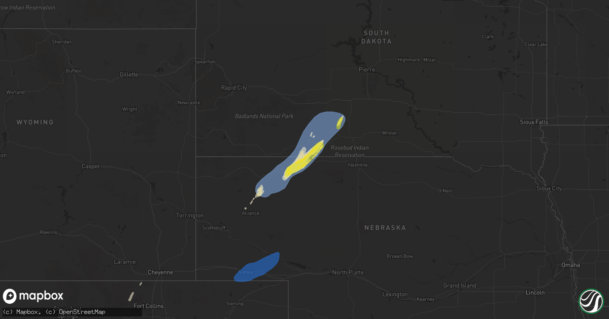
Hail Map on October 4, 2025
Get this storm
October 4 map
$229
one time, instant access
Download today. No call, no setup
Keep the $229
Bought the map and want the full workflow? Apply the entire $229 to a subscription within 7 days. None of it is wasted.
Every map, not just this one
This buys you this map. Subscription and you get every map we run, in the markets you choose from a few cities to whole states to nationwide. Plus real-time alerts the moment a storm fires.
Contact data
Name, contact info, occupancy, even credit band for addresses in the footprint. You go from where it hit to who to call.
Become the source they trust
Unlimited branding weather history reports on demand. You already have the documented answer ready for the property owner, and you are the one who showed up with it.
Property data and RoofTrace estimates
Pull up any address you have got, its value and the exact code rules for that jurisdiction, straight from One Click Code. Then RoofTrace estimates the squares, pitch, and roof value, priced the way you price.
States Impacted by Hail Map on October 4, 2025
Storm reports
North Dakota
| Date | Description |
|---|---|
| 10/04/202512:41 AM CDT | A local report indicates 63 MPH wind near 4 NW Grand Forks |
| 10/04/202512:32 AM CDT | Corrects previous tstm wnd gst report time from 4 nw grand forks. |
Colorado
| Date | Description |
|---|---|
| 10/04/20252:20 PM CDT | Mesonet station aw342 highlands ranch occurred with decaying thunderstorm. |
| 10/04/20251:15 PM CDT | A local report indicates 71 MPH wind near 3 ESE Rifle |
| 10/04/202511:38 AM CDT | Mesonet station co098 139s034 douglas pass. |
| 10/04/202510:26 AM CDT | Asos station kmtj montrose rgnl airport. |
Nebraska
| Date | Description |
|---|---|
| 10/04/20256:50 PM CDT | Corrects previous non-tstm wnd gst report from 8 w lodgepole. Mesonet station up252 8.1 w lodgepole |
| 10/04/20256:47 PM CDT | Corrects previous non-tstm wnd gst report from 2 ssw sidney. Peak gust of 68 mph. |
| 10/04/20256:23 PM CDT | Corrects previous non-tstm wnd gst report from 7 wnw lorenzo. Mesonet station fw8225 sidney. |
| 10/03/20259:37 PM CDT | Relayed report from spotter of a large pine tree down by the school. |
| 10/03/20257:28 PM CDT | Reports of power lines down in town. |
| 10/03/20257:22 PM CDT | Estimated time of 7:22 pm. A cedar tree fell on a house and broke out a window and power line down near the high school. Estimated winds of 60 mph. |
| 10/03/20257:00 PM CDT | A local report indicates 59 MPH wind near 13 SSE Hay Springs |
South Dakota
| Date | Description |
|---|---|
| 10/03/20258:40 PM CDT | A local report indicates 65 MPH wind near 3 NNE Harrington |
| 10/03/20258:30 PM CDT | A local report indicates 71 MPH wind near 4 ENE Martin |
Cities Impacted by Hail Map on October 4, 2025
- Wetmore, CO
- Gardner, CO
- Westcliffe, CO
- Bellvue, CO
- Livermore, CO
- Alliance, NE
- Hay Springs, NE
- Sidney, NE
- Lodgepole, NE
- Crook, CO
- Peetz, CO
- Dalton, NE
- Gurley, NE
- Bridgeport, NE
- Chappell, NE
- Broadwater, NE
- Oshkosh, NE
- Potter, NE
- Dix, NE
- Gordon, NE
- Rushville, NE
- Bingham, NE
- Merriman, NE
- Lisco, NE
- Hemingford, NE
- Strathcona, MN
- Greenbush, MN
- Martin, SD
- Tuthill, SD
- Badger, MN
- Kennedy, MN
- Karlstad, MN
- Halma, MN
- Allen, SD
- Wanblee, SD
- Norris, SD
- Long Valley, SD
- Parmelee, SD
- Donaldson, MN
- Lake Bronson, MN
- Roseau, MN
- White River, SD
- Fredonia, ND
- Kulm, ND
- Jamestown, ND
- Spiritwood, ND
- Sanborn, ND
- Northwood, ND
- Larimore, ND
- Arvilla, ND
- Drayton, ND
- Manvel, ND
- Mekinock, ND
- Argyle, MN
- Grand Forks, ND
- East Grand Forks, MN
- Emerado, ND
- De Beque, CO
- Rangely, CO