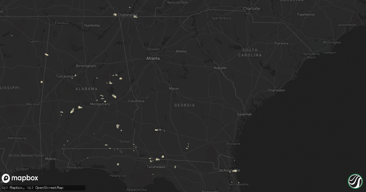
Hail Map in Georgia on July 22, 2015
Get this storm
July 22 map
$229
one time, instant access
Download today. No call, no setup
Keep the $229
Bought the map and want the full workflow? Apply the entire $229 to a subscription within 7 days. None of it is wasted.
Every map, not just this one
This buys you this map. Subscription and you get every map we run, in the markets you choose from a few cities to whole states to nationwide. Plus real-time alerts the moment a storm fires.
Contact data
Name, contact info, occupancy, even credit band for addresses in the footprint. You go from where it hit to who to call.
Become the source they trust
Unlimited branding weather history reports on demand. You already have the documented answer ready for the property owner, and you are the one who showed up with it.
Property data and RoofTrace estimates
Pull up any address you have got, its value and the exact code rules for that jurisdiction, straight from One Click Code. Then RoofTrace estimates the squares, pitch, and roof value, priced the way you price.
Storm reports in Georgia
Georgia
| Date | Description |
|---|---|
| 07/22/20156:30 PM CDT | Tree blown down along highway 319 near mile marker 6. |
| 07/22/20156:27 PM CDT | One tree down on whitehurst street. |
| 07/22/20156:27 PM CDT | Trained spotter reported multiple trees down and a metal shed damaged at the intersection of hwy 80 at hwy 25 near hopeulikit. |
| 07/22/20155:14 PM CDT | Three trees down along hwy 135 n. |
| 07/22/20154:57 PM CDT | One tree down on south morris ave between hwy 84 and hwy 91. |
| 07/22/20154:55 PM CDT | Several trees were blown down in gilmer county. |
| 07/22/20154:26 PM CDT | Tree blown down onto spooner quarter road. |
| 07/22/20154:20 PM CDT | Several trees were blown down...including on hwy 411 north...hwy 411 south...and hwy 52 alternate. |
| 07/22/20154:00 PM CDT | Several reports of trees and power lines down across the city of albany. |
| 07/22/20153:50 PM CDT | 53 knot peak gust measured at moody afb. Trees also reported down near the north gate of the base via a social media post to walb-tv facebook page. |
| 07/22/20153:36 PM CDT | Trees and powerlines down in graves... Ga. |
| 07/22/20153:25 PM CDT | Power line down near the intersection of spring flats road and greenleaf road. |
| 07/22/20152:58 PM CDT | Pole down on a residence on cordele road near staton drive. |
| 07/22/20152:55 PM CDT | Power lines down along branch road. |
All States Impacted by Hail Map on July 22, 2015
Cities Impacted by Hail Map on July 22, 2015
- Attica, KS
- Glencoe, OK
- Stillwater, OK
- Isabel, KS
- Nashville, KS
- Atwood, KS
- Box Springs, GA
- Colby, KS
- Havana, FL
- Graceville, FL
- Soddy Daisy, TN
- Thomasville, AL
- McGehee, AR
- Thomasville, GA
- Hamill, SD
- Gregory, SD
- Alberta, AL
- Bell Buckle, TN
- Perry, OK
- Albany, GA
- Atmore, AL
- Arlington, AL
- Pine Hill, AL
- Magnolia, AL
- Puposky, MN
- Bemidji, MN
- Sulligent, AL
- Valley, AL
- Stratton, NE
- Palisade, NE
- Texhoma, OK
- Stratford, TX
- Hollywood, SC
- Trenton, NE
- Anthony, KS
- Culbertson, NE
- Gordon, AL
- Skipperville, AL
- Bascom, FL
- Chipley, FL
- Notasulga, AL
- Bonifay, FL
- Burbank, OK
- Rexford, KS
- Gem, KS
- Oakley, KS
- Lance Creek, WY
- South Pittsburg, TN
- Ashland, AL
- Harper, KS
- Nashville, GA
- Lusk, WY
- Cass Lake, MN
- Wetumpka, AL
- Hilton Head Island, SC
- Pratt, KS
- Monument, KS
- Lakeland, GA
- Valdosta, GA
- Nowata, OK
- Attapulgus, GA
- Quincy, FL
- Saint Augustine, FL
- Macon, MS
- Oxford, MS
- Abbeville, MS
- Ripley, OK
- Agra, OK
- Cushing, OK
- Holt, FL
- Guthrie, OK
- Gattman, MS
- Reliance, SD
- Batesville, MS
- Courtland, MS
- Alexander City, AL
- Sardis, AL
- Fernandina Beach, FL
- Clio, AL
- Ariton, AL
- Tallahassee, FL
- Ringgold, GA
- Apison, TN
- Wadley, AL
- Waukomis, OK
- Prattville, AL
- Millbrook, AL
- Sawyer, KS
- Tallassee, AL
- Montgomery, AL
- Yale, OK
- Selma, AL
- Eddyville, NE
- Oconto, NE
- Titus, AL
- Geneva, AL
- Bald Knob, AR
- Stroud, OK
- Camp Hill, AL
- Dadeville, AL
- Chelsea, OK
- Jacksonville, FL
- Donalsonville, GA
- Crawford, NE
- Searcy, AR
- Fort Pierce, FL
- Enid, MS
- Pope, MS
- McCalla, AL
- Woodstock, AL
- Torrington, WY
- Orrville, AL
- Camden, AL
- Kellyton, AL
- Goodwater, AL
- Timberon, NM
- Cloudcroft, NM
- Tulsa, OK
- Sand Springs, OK
- Shelbyville, TN
- Medicine Lodge, KS
- Pawnee, OK
- Hayes Center, NE
- Gould, AR
- Drumright, OK
- Sylvester, GA
- Zenda, KS
- Cragford, AL
- Lineville, AL
- Neptune Beach, FL
- Jacksonville Beach, FL
- Rohwer, AR
- Perkins, OK
- Cottondale, AL
- Vance, AL
- Sedan, KS
- Samson, AL
- Kinston, AL
- Hawthorne, FL
- Augusta, AR
- Perdido, AL
- Drummond, OK
- Childersburg, AL
- Sylacauga, AL
- Merino, CO
- Ooltewah, TN
- Cohutta, GA
- Harrison, NE
- Atlantic Beach, FL
- Caledonia, MS
- Vernon, AL
- Greenville, FL
- Dozier, AL
- Andalusia, AL
- Kaw City, OK
- Shidler, OK
- Orlando, FL
- Milan, KS
- Crawfordville, FL
- Geuda Springs, KS
- Depew, OK


