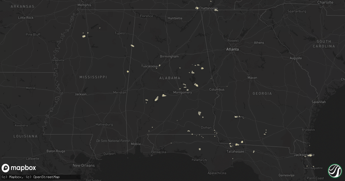
Hail Map in Alabama on July 22, 2015
Get this storm
July 22 map
$229
one time, instant access
Download today. No call, no setup
Keep the $229
Bought the map and want the full workflow? Apply the entire $229 to a subscription within 7 days. None of it is wasted.
Every map, not just this one
This buys you this map. Subscription and you get every map we run, in the markets you choose from a few cities to whole states to nationwide. Plus real-time alerts the moment a storm fires.
Contact data
Name, contact info, occupancy, even credit band for addresses in the footprint. You go from where it hit to who to call.
Become the source they trust
Unlimited branding weather history reports on demand. You already have the documented answer ready for the property owner, and you are the one who showed up with it.
Property data and RoofTrace estimates
Pull up any address you have got, its value and the exact code rules for that jurisdiction, straight from One Click Code. Then RoofTrace estimates the squares, pitch, and roof value, priced the way you price.
Storm reports in Alabama
Alabama
| Date | Description |
|---|---|
| 07/22/20156:46 PM CDT | Tree down |
| 07/22/20156:37 PM CDT | Tree down near highway 9 and santuck |
| 07/22/20156:26 PM CDT | Tree down on noahs rd near wallsboro |
| 07/22/20154:40 PM CDT | Several trees down including large trees 1 mile west of dickert along highway 22. |
| 07/22/20154:27 PM CDT | One tree down on the railroad tracks near highway 25 and horton cove rd |
| 07/22/20154:15 PM CDT | Tree down near the cragford community. Also numerous trees down in multiple locations across the southern half of the county. Corrected for additional reports. |
| 07/22/20154:07 PM CDT | Tree down at oak street and 7th avenue. |
| 07/22/20154:04 PM CDT | Trees down along highway 22 near new site. Reported via social media. |
| 07/22/20153:55 PM CDT | Tree down along owens rd near ashland. Corrected report. |
| 07/22/20153:35 PM CDT | Two trees down on a powerline on 4 oaks road near henson springs. |
| 07/22/20153:30 PM CDT | Trees down in along hells creek rd and mitchell rd. Time estimated from radar. |
| 07/22/20153:24 PM CDT | Mobile home destroyed by a fallen tree on turkey creek rd. |
| 07/22/20153:15 PM CDT | One tree down along abernathy rd. Time estimated from radar. |
| 07/22/20152:53 PM CDT | One tree down along old sylacauga hwy near the water plant. Time estimated from radar. |
| 07/22/20152:50 PM CDT | *** 1 inj *** trees and power lines down along old birmingham hwy near intersection with gantts junction rd. One tree on a house with one person sustaining minor injuri |
| 07/22/20152:35 PM CDT | One tree down near the intersection of cedar creek rd and 7 sweet gums rd. Time estimated from radar. |
| 07/22/20151:24 PM CDT | Few trees down along south shades crest rd between hwy 150 and hwy 52. Time estimated from radar. |
| 07/21/20158:07 PM CDT | One tree down at coosada road at coosada creek. |
| 07/21/20157:56 PM CDT | One tree and one large limb down in the city of millbrook. |
All States Impacted by Hail Map on July 22, 2015
Cities Impacted by Hail Map on July 22, 2015
- Attica, KS
- Glencoe, OK
- Stillwater, OK
- Isabel, KS
- Nashville, KS
- Atwood, KS
- Box Springs, GA
- Colby, KS
- Havana, FL
- Graceville, FL
- Soddy Daisy, TN
- Thomasville, AL
- McGehee, AR
- Thomasville, GA
- Hamill, SD
- Gregory, SD
- Alberta, AL
- Bell Buckle, TN
- Perry, OK
- Albany, GA
- Atmore, AL
- Arlington, AL
- Pine Hill, AL
- Magnolia, AL
- Puposky, MN
- Bemidji, MN
- Sulligent, AL
- Valley, AL
- Stratton, NE
- Palisade, NE
- Texhoma, OK
- Stratford, TX
- Hollywood, SC
- Trenton, NE
- Anthony, KS
- Culbertson, NE
- Gordon, AL
- Skipperville, AL
- Bascom, FL
- Chipley, FL
- Notasulga, AL
- Bonifay, FL
- Burbank, OK
- Rexford, KS
- Gem, KS
- Oakley, KS
- Lance Creek, WY
- South Pittsburg, TN
- Ashland, AL
- Harper, KS
- Nashville, GA
- Lusk, WY
- Cass Lake, MN
- Wetumpka, AL
- Hilton Head Island, SC
- Pratt, KS
- Monument, KS
- Lakeland, GA
- Valdosta, GA
- Nowata, OK
- Attapulgus, GA
- Quincy, FL
- Saint Augustine, FL
- Macon, MS
- Oxford, MS
- Abbeville, MS
- Ripley, OK
- Agra, OK
- Cushing, OK
- Holt, FL
- Guthrie, OK
- Gattman, MS
- Reliance, SD
- Batesville, MS
- Courtland, MS
- Alexander City, AL
- Sardis, AL
- Fernandina Beach, FL
- Clio, AL
- Ariton, AL
- Tallahassee, FL
- Ringgold, GA
- Apison, TN
- Wadley, AL
- Waukomis, OK
- Prattville, AL
- Millbrook, AL
- Sawyer, KS
- Tallassee, AL
- Montgomery, AL
- Yale, OK
- Selma, AL
- Eddyville, NE
- Oconto, NE
- Titus, AL
- Geneva, AL
- Bald Knob, AR
- Stroud, OK
- Camp Hill, AL
- Dadeville, AL
- Chelsea, OK
- Jacksonville, FL
- Donalsonville, GA
- Crawford, NE
- Searcy, AR
- Fort Pierce, FL
- Enid, MS
- Pope, MS
- McCalla, AL
- Woodstock, AL
- Torrington, WY
- Orrville, AL
- Camden, AL
- Kellyton, AL
- Goodwater, AL
- Timberon, NM
- Cloudcroft, NM
- Tulsa, OK
- Sand Springs, OK
- Shelbyville, TN
- Medicine Lodge, KS
- Pawnee, OK
- Hayes Center, NE
- Gould, AR
- Drumright, OK
- Sylvester, GA
- Zenda, KS
- Cragford, AL
- Lineville, AL
- Neptune Beach, FL
- Jacksonville Beach, FL
- Rohwer, AR
- Perkins, OK
- Cottondale, AL
- Vance, AL
- Sedan, KS
- Samson, AL
- Kinston, AL
- Hawthorne, FL
- Augusta, AR
- Perdido, AL
- Drummond, OK
- Childersburg, AL
- Sylacauga, AL
- Merino, CO
- Ooltewah, TN
- Cohutta, GA
- Harrison, NE
- Atlantic Beach, FL
- Caledonia, MS
- Vernon, AL
- Greenville, FL
- Dozier, AL
- Andalusia, AL
- Kaw City, OK
- Shidler, OK
- Orlando, FL
- Milan, KS
- Crawfordville, FL
- Geuda Springs, KS
- Depew, OK


