Hail Map in Delaware on July 1, 2021
Get this storm
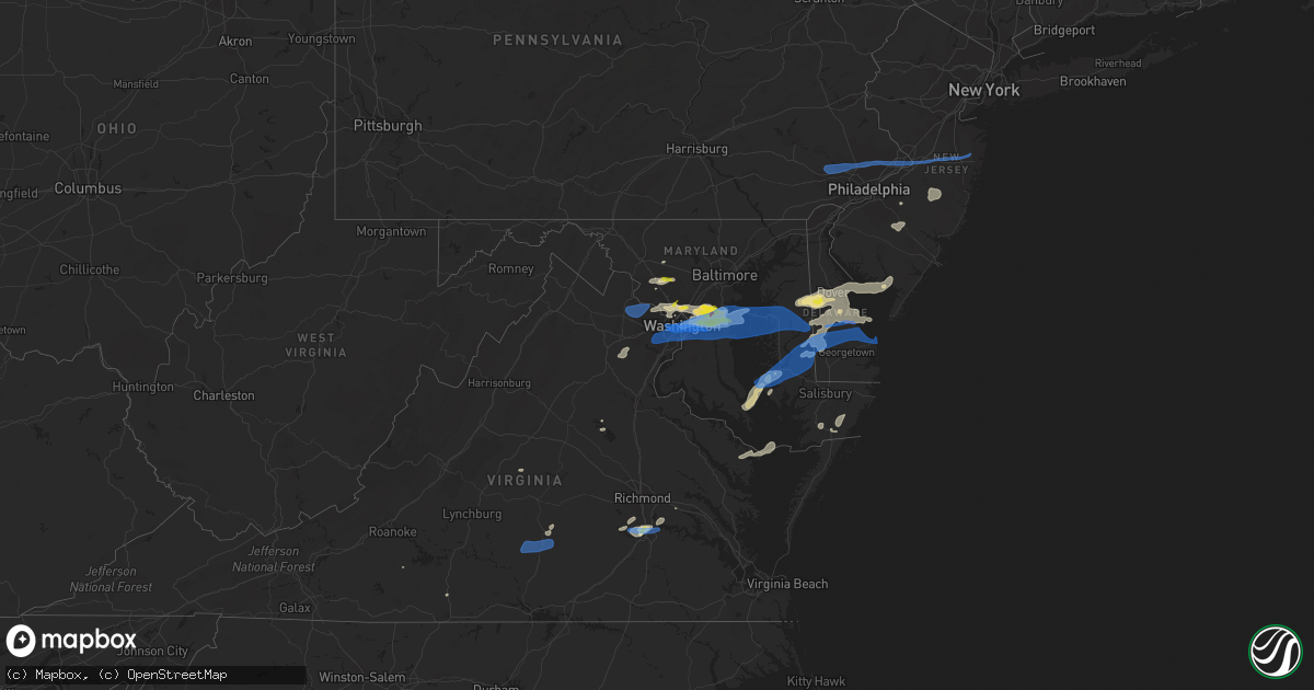
July 1 map
$229
one time, instant access
Download today. No call, no setup
Keep the $229
Bought the map and want the full workflow? Apply the entire $229 to a subscription within 7 days. None of it is wasted.
Every map, not just this one
This buys you this map. Subscription and you get every map we run, in the markets you choose from a few cities to whole states to nationwide. Plus real-time alerts the moment a storm fires.
Contact data
Name, contact info, occupancy, even credit band for addresses in the footprint. You go from where it hit to who to call.
Become the source they trust
Unlimited branding weather history reports on demand. You already have the documented answer ready for the property owner, and you are the one who showed up with it.
Property data and RoofTrace estimates
Pull up any address you have got, its value and the exact code rules for that jurisdiction, straight from One Click Code. Then RoofTrace estimates the squares, pitch, and roof value, priced the way you price.
Storm reports in Delaware
Delaware
| Date | Description |
|---|---|
| 07/01/20216:05 PM CDT | Damage to shingles and siding of several houses. Time estimated from radar. |
| 07/01/20215:32 PM CDT | Several reports of trees and wires down near route 18 southeast of bridgeville. Time estimated from radar. |
| 07/01/20214:24 PM CDT | Nos gauge lwsd1. |
| 07/01/20214:19 PM CDT | Downed power poles and wires near morris mill road. Time estimated from radar. |
| 07/01/20214:18 PM CDT | Nos gauge lwsd1. |
| 07/01/20214:03 PM CDT | Several large trees downed. Time estimated from radar. |
| 07/01/20214:02 PM CDT | Significant tree damage with some trees into houses. |
| 07/01/20214:00 PM CDT | Roof damage to a mobile home on hunting quarter road near williamsville... De. Time estimated from radar. Social media report. |
| 07/01/20214:00 PM CDT | Updates previous tornado report from 3 ene milford to reflect storm survey results. Damage was first observed near residences at the cedar beach road and mccolley road |
| 07/01/20213:58 PM CDT | Downed trees and wires near thistlewood road. Time estimated from radar. |
| 07/01/20213:53 PM CDT | Downed wires on hall street... Alder lane... And near the intersection of neals school road and boyce road in seaford. Time estimated from radar. |
| 07/01/20213:53 PM CDT | Several reports of downed trees and wires northeast of bridgeville. Time estimated from radar. |
| 07/01/20213:52 PM CDT | Trees down and vehicles blown off the road along u.s route 13 around tower hill road. |
| 07/01/20213:52 PM CDT | Trees and utility lines down with debris in the roadway. |
| 07/01/20213:52 PM CDT | Wind damage was first observed near a residence on farmington road... Knocking down and snapping several trees in a narrow swath. The tornado then continued over railro |
| 07/01/20213:50 PM CDT | Downed tree limbs and wires near craigs mill road and woodland road. Time estimated from radar. |
| 07/01/20213:42 PM CDT | Several reports of downed tree limbs and wires north of felton. Time estimated from radar. |
| 07/01/20213:42 PM CDT | Downed trees and power lines near woodpecker road. Time estimated from radar. |
| 07/01/20213:26 PM CDT | Downed tree limbs and wires east of hartly. Time estimated from radar. |
| 07/01/20215:35 AM CDT | At 1035 PM EDT, a severe thunderstorm was located over Chestertown, or 12 miles north of Centerville, moving southeast at 20 mph. HAZARD...60 mph wind gusts and penny size hail. SOURCE...Radar indicated. IMPACT...Damage to roofs, siding, trees, and power lines is possible. Locations impacted include... Chestertown, Church Hill, Millington, Sudlersville, Morgnec, Crumpton, Langford, Barclay and Kingstown. |
| 06/30/202111:55 PM CDT | At 454 PM EDT, severe thunderstorms were located along a line extending from Quinton to 6 miles south of Woodland Beach to near Big Stone Beach, moving east at 25 mph. HAZARD...60 mph wind gusts and penny size hail. SOURCE...Radar indicated. IMPACT...Damage to roofs, siding, trees, and power lines is possible. Locations impacted include... Vineland, Millville, Bridgeton, Cape May, Cumberland, Pennsville, Salem, North Wildwood, Laurel Lake, Woodstown, Alloway, Wildwood Crest, Quinton, Woodbine, Sea Isle City, Elmer, Avalon, West Cape May, Stone Harbor and Greenwich.This includes Garden State Parkway between mile markers 0 and 19. |
| 06/30/202111:32 PM CDT | At 431 PM EDT, severe thunderstorms were located along a line extending from near Old Town to Greensboro to Federalsburg to near Sharptown, moving east at 45 mph. HAZARD...70 mph wind gusts and quarter size hail. SOURCE...Radar indicated. IMPACT...Minor damage to vehicles is possible. Expect considerable tree damage. Wind damage is also likely to mobile homes, roofs, and outbuildings. Locations impacted include... Dover, Georgetown, Centerville, Smyrna, Milford, Seaford, Chestertown, Denton, Centreville, Millsboro, Laurel, Harrington, Camden, Clayton, Lewes, Federalsburg, Milton, Selbyville, Bridgeville and Greensboro. |
| 06/30/202111:27 PM CDT | At 426 PM EDT, severe thunderstorms were located along a line extending from New Hope to Bryn Athyn to near Newtown Square to Delaware City, moving east at 25 mph. HAZARD...60 mph wind gusts. SOURCE...Law enforcement. IMPACT...Damage to roofs, siding, trees, and power lines is possible. Locations impacted include... Philadelphia, Trenton, Camden, Wilmington, Gloucester City, Bensalem, Ewing, Chester, Willingboro, Deptford, West Deptford, Glassboro, Pennsville, Princeton, Florence, Bellmawr, Yeadon, Woodbury, Burlington and Bristol.People at the Welcome America Events should seek safe shelterimmediately!This includes the following highways... New Jersey Turnpike between exits 1 and 3, and between exits 6 and6A. Pennsylvania Turnpike between mile markers 341 and 359. Interstate 95 in Pennsylvania between mile markers 0 and 40. Interstate 95 in Delaware between mile markers 11 and 23. Interstate 76 in Pennsylvania between mile markers 335 and 351. Interstate 76 in New Jersey between mile markers 0 and 3. Interstate 195 in New Jersey between mile markers 0 and 3. Interstate 295 in New Jersey between mile markers 0 and 30, andbetween mile markers 55 and 76. Interstate 676 in Pennsylvania between mile markers 0 and 1. Interstate 676 in New Jersey between mile markers 0 and 4. Interstate 476 in Pennsylvania between mile markers 0 and 11. |
| 06/30/202111:15 PM CDT | At 414 PM EDT, severe thunderstorms were located along a line extending from Trappe to Secretary to near Vienna, moving northeast at 55 mph. HAZARD...70 mph wind gusts and quarter size hail. SOURCE...Radar indicated. IMPACT...Minor damage to vehicles is possible. Expect considerable tree damage. Wind damage is also likely to mobile homes, roofs, and outbuildings. Severe thunderstorms will be near, Hurlock around 420 PM EDT.Other locations impacted by these severe thunderstorms includeGalestown, Brookview, East New Market and Eldorado. |
| 06/30/202111:08 PM CDT | At 407 PM EDT, a severe thunderstorm was located over Cambridge, moving northeast at 55 mph. HAZARD...70 mph wind gusts and nickel size hail. SOURCE...Radar indicated. IMPACT...Expect considerable tree damage. Damage is likely to mobile homes, roofs, and outbuildings. Locations impacted include... Easton, Seaford, Federalsburg, Trappe, Preston, Oxford, Tanyard, Harmony, Copperville, Agner, Matthews, Choptank, Hambleton, Windyhill, Cordova, Blades and Bethel. |
| 06/30/202110:51 PM CDT | At 351 PM EDT, severe thunderstorms were located along a line extending from near Breezy Point to 7 miles north of Deal Island, moving northeast at 35 mph. HAZARD...60 mph wind gusts and quarter size hail. SOURCE...Radar indicated. IMPACT...Minor damage to vehicles is possible. Expect wind damage to trees and powerlines. Severe thunderstorms will be near, Vienna around 420 PM EDT. Hebron around 430 PM EDT.Other locations impacted by these severe thunderstorms includeCatchpenny, Wetipquin, Brookview, Eldorado, Andrews, Hoopersville,Royal Oak, Hudson, Honga and Church Creek. |
All States Impacted by Hail Map on July 1, 2021
Cities Impacted by Hail Map on July 1, 2021
- Roggen, CO
- Laramie, WY
- Hugoton, KS
- Manchester Township, NJ
- Vincentown, NJ
- Chatsworth, NJ
- Browns Mills, NJ
- Cheyenne, WY
- Greeley, CO
- Medford, NJ
- Cottonwood, ID
- Esmont, VA
- Howardsville, VA
- Pemberton, NJ
- Pocomoke City, MD
- Clarksburg, MD
- Damascus, MD
- Gaithersburg, MD
- Germantown, MD
- Elbert, CO
- Greenbelt, MD
- Crofton, MD
- Crownsville, MD
- Brentwood, MD
- Upper Marlboro, MD
- Capitol Heights, MD
- Hyattsville, MD
- Annapolis, MD
- Bowie, MD
- College Park, MD
- Davidsonville, MD
- Glenn Dale, MD
- Beltsville, MD
- Lanham, MD
- Riverdale, MD
- Odenton, MD
- Riva, MD
- Laurel, MD
- Edgewater, MD
- Bladensburg, MD
- Gambrills, MD
- Washington, DC
- Avondale, CO
- Boone, CO
- Pueblo, CO
- Kim, CO
- Rice, VA
- Farmville, VA
- Chesterfield, VA
- Chester, VA
- Petersburg, VA
- Colonial Heights, VA
- Great Falls, VA
- Garrett Park, MD
- Kensington, MD
- Potomac, MD
- Rockville, MD
- Silver Spring, MD
- Bethesda, MD
- Centreville, MD
- Ingleside, MD
- Magnolia, DE
- Goldsboro, MD
- Henderson, MD
- Camden Wyoming, DE
- Marydel, DE
- Hartly, DE
- Felton, DE
- Marydel, MD
- Barclay, MD
- Dover, DE
- Mclean, TX
- Dickerson, MD
- Boyds, MD
- Barnesville, MD
- Windsor, CO
- Kiowa, CO
- Turkey, TX
- Garrett, WY
- Watkins, CO
- Bennett, CO
- Casper, WY
- Hoffman, NC
- Wagram, NC
- Marston, NC
- Aberdeen, NC
- Chevy Chase, MD
- Grangeville, ID
- Polebridge, MT
- Fowler, CO
- Millville, NJ
- Fountain, CO
- Cambridge, MD
- Taylors Island, MD
- Lexington Park, MD
- Woolford, MD
- Church Creek, MD
- Patuxent River, MD
- Madison, MD
- Yoder, WY
- Calhan, CO
- Polson, MT
- Charles City, VA
- Haines, OR
- Corvallis, MT
- Raeford, NC
- Pinebluff, NC
- Frederica, DE
- Wheatland, WY
- Prairie City, OR
- Shawnee, OK
- Spotsylvania, VA
- Greenwood, DE
- Bridgeville, DE
- Mineral, VA
- Fort George G Meade, MD
- Delmont, NJ
- Cabin John, MD
- Glen Echo, MD
- Mount Rainier, MD
- Harwood, MD
- McLean, VA
- Arlington, VA
- Lake George, CO
- Viola, DE
- Woodside, DE
- Church Hill, MD
- Heislerville, NJ
- Leesburg, NJ
- Dover Afb, DE
- Port Norris, NJ
- Seaford, DE
- Federalsburg, MD
- Dorchester, NJ
- Harrington, DE
- Newport, NJ
- Houston, DE
- Denton, MD
- Milford, DE
- Greensboro, MD
- Waterford Works, NJ
- Williamstown, NJ
- Sicklerville, NJ
- Hammonton, NJ
- Bonner, MT
- Hopewell, VA
- Kalispell, MT
- Morral, OH
- Harpster, OH
- Upper Sandusky, OH
- Mount Airy, MD
- Okarche, OK
- Rocky Mount, VA
- Rocky Ford, CO
- Model, CO
- Heathsville, VA
- Burgess, VA
- Reedville, VA
- Kaycee, WY
- Clarendon, TX
- Hurlock, MD
- Providence Forge, VA
- Whitefish, MT
- Nokesville, VA
- Catlett, VA
- Westover, MD
- Dry Fork, VA
- Danville, VA
- Chatham, VA
- Agate, CO
- Deer Trail, CO
- Snow Hill, MD
- Vass, NC
- Broadway, NC
- Cameron, NC
- Sanford, NC
- Lillington, NC
- Leesburg, VA
- Sterling, VA
- Ashburn, VA
- Aldie, VA
- Queen Anne, MD
- Annandale, VA
- Mcdaniel, MD
- Alexandria, VA
- Fairfax, VA
- Arnold, MD
- Ridgely, MD
- Fairfax Station, VA
- Claiborne, MD
- Saint Michaels, MD
- Andrews Air Force Base, MD
- Queenstown, MD
- Severna Park, MD
- Grasonville, MD
- District Heights, MD
- Rock Hall, MD
- Clifton, VA
- Cordova, MD
- Springfield, VA
- Shady Side, MD
- Falls Church, VA
- Wye Mills, MD
- Galesville, MD
- Suitland, MD
- Hillsboro, MD
- Stevensville, MD
- West River, MD
- Lothian, MD
- Fort Washington, MD
- Burke, VA
- Easton, MD
- Naval Anacost Annex, DC
- Deale, MD
- Oxon Hill, MD
- Churchton, MD
- Temple Hills, MD
- Fort Myer, VA
- Chester, MD
- Prince George, VA
- Secretary, MD
- Rhodesdale, MD
- Lincoln, DE
- Milton, DE
- East New Market, MD
- Trappe, MD
- Preston, MD
- Linkwood, MD
- Ellendale, DE
- Lewes, DE
- Vienna, MD
- Cullen, VA
- Charlotte Court House, VA
- Pamplin, VA
- Green Bay, VA
- Keysville, VA
- Meherrin, VA
- Mont Clare, PA
- Chester Springs, PA
- Wayne, PA
- Collegeville, PA
- Hatboro, PA
- Levittown, PA
- Bensalem, PA
- Bordentown, NJ
- Howell, NJ
- Huntingdon Valley, PA
- Willow Grove, PA
- Millstone Township, NJ
- Oaks, PA
- Dresher, PA
- Bridgeport, PA
- King Of Prussia, PA
- Robbinsville, NJ
- Bryn Athyn, PA
- Norristown, PA
- Freehold, NJ
- Abington, PA
- Langhorne, PA
- Horsham, PA
- Plymouth Meeting, PA
- Trenton, NJ
- Blue Bell, PA
- Cream Ridge, NJ
- Chesterfield, NJ
- Farmingdale, NJ
- Allentown, NJ
- Phoenixville, PA
- Fort Washington, PA
- Morrisville, PA
- Feasterville Trevose, PA
- Bristol, PA
- Fairless Hills, PA
- Southampton, PA
- Malvern, PA
- Ambler, PA
- Flourtown, PA


