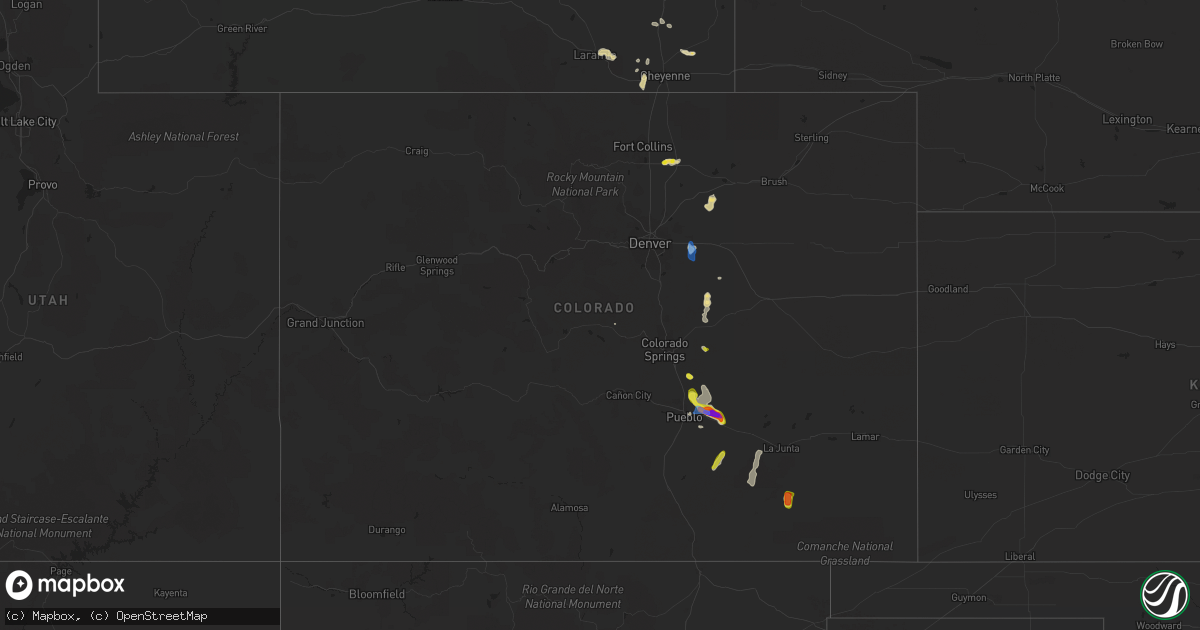
Hail Map in Colorado on July 1, 2021
Get this storm
July 1 map
$229
one time, instant access
Download today. No call, no setup
Keep the $229
Bought the map and want the full workflow? Apply the entire $229 to a subscription within 7 days. None of it is wasted.
Every map, not just this one
This buys you this map. Subscription and you get every map we run, in the markets you choose from a few cities to whole states to nationwide. Plus real-time alerts the moment a storm fires.
Contact data
Name, contact info, occupancy, even credit band for addresses in the footprint. You go from where it hit to who to call.
Become the source they trust
Unlimited branding weather history reports on demand. You already have the documented answer ready for the property owner, and you are the one who showed up with it.
Property data and RoofTrace estimates
Pull up any address you have got, its value and the exact code rules for that jurisdiction, straight from One Click Code. Then RoofTrace estimates the squares, pitch, and roof value, priced the way you price.
Storm reports in Colorado
Colorado
| Date | Description |
|---|---|
| 07/01/20216:12 PM CDT | Power poles knocked completely over... With excessive tree damage in the area. |
| 07/01/20215:45 PM CDT | Golf ball to baseball size hail lasted through around 515 pm. |
| 07/01/20215:45 PM CDT | 5 empty rail cars flipped. Power lines downed. Time of damage estimated. |
| 07/01/20215:33 PM CDT | A local report indicates 67 MPH wind near 5 NE BLENDE |
| 07/01/20215:32 PM CDT | A local report indicates 61 MPH wind near 5 NE BLENDE |
| 07/01/20213:55 PM CDT | A local report indicates 58 MPH wind near BENNETT |
| 07/01/20213:30 PM CDT | A local report indicates 1.00 inch wind near 1 SSW ELLICOTT |
| 07/01/20213:02 PM CDT | A local report indicates 1.00 inch wind near GREELEY |
| 07/01/20212:39 PM CDT | Report from mping: half dollar |
| 07/01/20211:56 AM CDT | At 655 PM MDT, a severe thunderstorm was located 7 miles southwest of Rocky Ford, or 13 miles west of La Junta, moving north at 20 mph. HAZARD...70 mph wind gusts and ping pong ball size hail. SOURCE...Radar indicated. IMPACT...People and animals outdoors will be injured. Expect hail damage to roofs, siding, windows, and vehicles. Expect considerable tree damage. Wind damage is also likely to mobile homes, roofs, and outbuildings. Locations impacted include... Rocky Ford, Swink, Manzanola and Timpas. |
| 07/01/202112:38 AM CDT | At 538 PM MDT, a severe thunderstorm was located 20 miles northwest of Delhi, or 34 miles southeast of Pueblo, moving north at 10 mph. HAZARD...60 mph wind gusts and half dollar size hail. SOURCE...Radar indicated. IMPACT...Hail damage to vehicles is expected. Expect wind damage to roofs, siding, and trees. This severe thunderstorm will remain over mainly rural areas of southeastern Pueblo County. |
| 07/01/202112:35 AM CDT | At 535 PM MDT, a severe thunderstorm was located 14 miles south of Higbee, or 29 miles south of North La Junta, moving north at 10 mph. HAZARD...Two inch hail and 60 mph wind gusts. SOURCE...Radar indicated. IMPACT...People and animals outdoors will be injured. Expect hail damage to roofs, siding, windows, and vehicles. Expect wind damage to roofs, siding, and trees. This severe thunderstorm will remain over mainly rural areas of southeastern Otero, northeastern Las Animas and southwestern Bent Counties. |
| 07/01/202112:06 AM CDT | At 506 PM MDT, a severe thunderstorm was located over Boone, or 21 miles east of Pueblo, moving southeast at 20 mph. This is a very dangerous storm. HAZARD...Three inch hail and 70 mph wind gusts. SOURCE...Radar indicated. IMPACT...People and animals outdoors will be severely injured. Expect shattered windows, extensive damage to roofs, siding, and vehicles. Locations impacted include... Fowler, Olney Springs, Boone, Avondale and Pueblo Depot. |
| 06/30/202111:30 PM CDT | At 429 PM MDT, a severe thunderstorm was located near Pueblo Depot, or 10 miles northeast of Pueblo, moving southeast at 20 mph. HAZARD...60 mph wind gusts and half dollar size hail. SOURCE...Radar indicated. IMPACT...Hail damage to vehicles is expected. Expect wind damage to roofs, siding, and trees. Locations impacted include... Eastern Pueblo, Boone, Avondale and Pueblo Depot. |
| 06/30/202111:09 PM CDT | At 408 PM MDT, a severe thunderstorm was located near Pinon, or 11 miles northeast of Pueblo, and is nearly stationary. HAZARD...60 mph wind gusts and quarter size hail. SOURCE...Radar indicated. IMPACT...Hail damage to vehicles is expected. Expect wind damage to roofs, siding, and trees. Locations impacted include... Northern Pueblo and Pueblo Depot. |
| 06/30/202110:47 PM CDT | At 347 PM MDT, a severe thunderstorm was located near Pinon, or 13 miles northeast of Pueblo, moving south at 15 mph. HAZARD...60 mph wind gusts and quarter size hail. SOURCE...Radar indicated. IMPACT...Hail damage to vehicles is expected. Expect wind damage to roofs, siding, and trees. Locations impacted include... Northern Pueblo and Pueblo Depot. |
| 06/30/20219:42 PM CDT | At 242 PM MDT, a severe thunderstorm was located near Hanover, or 22 miles southeast of Colorado Springs, moving southeast at 10 mph. HAZARD...60 mph wind gusts and quarter size hail. SOURCE...Radar indicated. IMPACT...Hail damage to vehicles is expected. Expect wind damage to roofs, siding, and trees. Locations impacted include... Hanover. |
| 06/30/20219:34 PM CDT | At 234 PM MDT, a severe thunderstorm was located over Ellicott, or 25 miles east of Colorado Springs, moving southeast at 10 mph. HAZARD...60 mph wind gusts and quarter size hail. SOURCE...Trained weather spotters. IMPACT...Hail damage to vehicles is expected. Expect wind damage to roofs, siding, and trees. Locations impacted include... Yoder and Ellicott. |
| 06/30/20219:33 PM CDT | At 232 PM MDT, a severe thunderstorm was located near Calhan, or 32 miles northeast of Colorado Springs, moving east at 15 mph. HAZARD...60 mph wind gusts and quarter size hail. SOURCE...Radar indicated. IMPACT...Hail damage to vehicles is expected. Expect wind damage to roofs, siding, and trees. Locations impacted include... Calhan and Ramah. |
| 06/30/20219:26 PM CDT | At 226 PM MDT, a severe thunderstorm was located 4 miles south of Manila Village, or 22 miles east of Denver, moving south at 5 mph. HAZARD...60 mph wind gusts. SOURCE...Radar indicated. IMPACT...Expect damage to roofs, siding, and trees. This severe thunderstorm will remain over mainly rural areas of central Arapahoe County. |
All States Impacted by Hail Map on July 1, 2021
Cities Impacted by Hail Map on July 1, 2021
- Roggen, CO
- Laramie, WY
- Hugoton, KS
- Manchester Township, NJ
- Vincentown, NJ
- Chatsworth, NJ
- Browns Mills, NJ
- Cheyenne, WY
- Greeley, CO
- Medford, NJ
- Cottonwood, ID
- Esmont, VA
- Howardsville, VA
- Pemberton, NJ
- Pocomoke City, MD
- Clarksburg, MD
- Damascus, MD
- Gaithersburg, MD
- Germantown, MD
- Elbert, CO
- Greenbelt, MD
- Crofton, MD
- Crownsville, MD
- Brentwood, MD
- Upper Marlboro, MD
- Capitol Heights, MD
- Hyattsville, MD
- Annapolis, MD
- Bowie, MD
- College Park, MD
- Davidsonville, MD
- Glenn Dale, MD
- Beltsville, MD
- Lanham, MD
- Riverdale, MD
- Odenton, MD
- Riva, MD
- Laurel, MD
- Edgewater, MD
- Bladensburg, MD
- Gambrills, MD
- Washington, DC
- Avondale, CO
- Boone, CO
- Pueblo, CO
- Kim, CO
- Rice, VA
- Farmville, VA
- Chesterfield, VA
- Chester, VA
- Petersburg, VA
- Colonial Heights, VA
- Great Falls, VA
- Garrett Park, MD
- Kensington, MD
- Potomac, MD
- Rockville, MD
- Silver Spring, MD
- Bethesda, MD
- Centreville, MD
- Ingleside, MD
- Magnolia, DE
- Goldsboro, MD
- Henderson, MD
- Camden Wyoming, DE
- Marydel, DE
- Hartly, DE
- Felton, DE
- Marydel, MD
- Barclay, MD
- Dover, DE
- Mclean, TX
- Dickerson, MD
- Boyds, MD
- Barnesville, MD
- Windsor, CO
- Kiowa, CO
- Turkey, TX
- Garrett, WY
- Watkins, CO
- Bennett, CO
- Casper, WY
- Hoffman, NC
- Wagram, NC
- Marston, NC
- Aberdeen, NC
- Chevy Chase, MD
- Grangeville, ID
- Polebridge, MT
- Fowler, CO
- Millville, NJ
- Fountain, CO
- Cambridge, MD
- Taylors Island, MD
- Lexington Park, MD
- Woolford, MD
- Church Creek, MD
- Patuxent River, MD
- Madison, MD
- Yoder, WY
- Calhan, CO
- Polson, MT
- Charles City, VA
- Haines, OR
- Corvallis, MT
- Raeford, NC
- Pinebluff, NC
- Frederica, DE
- Wheatland, WY
- Prairie City, OR
- Shawnee, OK
- Spotsylvania, VA
- Greenwood, DE
- Bridgeville, DE
- Mineral, VA
- Fort George G Meade, MD
- Delmont, NJ
- Cabin John, MD
- Glen Echo, MD
- Mount Rainier, MD
- Harwood, MD
- McLean, VA
- Arlington, VA
- Lake George, CO
- Viola, DE
- Woodside, DE
- Church Hill, MD
- Heislerville, NJ
- Leesburg, NJ
- Dover Afb, DE
- Port Norris, NJ
- Seaford, DE
- Federalsburg, MD
- Dorchester, NJ
- Harrington, DE
- Newport, NJ
- Houston, DE
- Denton, MD
- Milford, DE
- Greensboro, MD
- Waterford Works, NJ
- Williamstown, NJ
- Sicklerville, NJ
- Hammonton, NJ
- Bonner, MT
- Hopewell, VA
- Kalispell, MT
- Morral, OH
- Harpster, OH
- Upper Sandusky, OH
- Mount Airy, MD
- Okarche, OK
- Rocky Mount, VA
- Rocky Ford, CO
- Model, CO
- Heathsville, VA
- Burgess, VA
- Reedville, VA
- Kaycee, WY
- Clarendon, TX
- Hurlock, MD
- Providence Forge, VA
- Whitefish, MT
- Nokesville, VA
- Catlett, VA
- Westover, MD
- Dry Fork, VA
- Danville, VA
- Chatham, VA
- Agate, CO
- Deer Trail, CO
- Snow Hill, MD
- Vass, NC
- Broadway, NC
- Cameron, NC
- Sanford, NC
- Lillington, NC
- Leesburg, VA
- Sterling, VA
- Ashburn, VA
- Aldie, VA
- Queen Anne, MD
- Annandale, VA
- Mcdaniel, MD
- Alexandria, VA
- Fairfax, VA
- Arnold, MD
- Ridgely, MD
- Fairfax Station, VA
- Claiborne, MD
- Saint Michaels, MD
- Andrews Air Force Base, MD
- Queenstown, MD
- Severna Park, MD
- Grasonville, MD
- District Heights, MD
- Rock Hall, MD
- Clifton, VA
- Cordova, MD
- Springfield, VA
- Shady Side, MD
- Falls Church, VA
- Wye Mills, MD
- Galesville, MD
- Suitland, MD
- Hillsboro, MD
- Stevensville, MD
- West River, MD
- Lothian, MD
- Fort Washington, MD
- Burke, VA
- Easton, MD
- Naval Anacost Annex, DC
- Deale, MD
- Oxon Hill, MD
- Churchton, MD
- Temple Hills, MD
- Fort Myer, VA
- Chester, MD
- Prince George, VA
- Secretary, MD
- Rhodesdale, MD
- Lincoln, DE
- Milton, DE
- East New Market, MD
- Trappe, MD
- Preston, MD
- Linkwood, MD
- Ellendale, DE
- Lewes, DE
- Vienna, MD
- Cullen, VA
- Charlotte Court House, VA
- Pamplin, VA
- Green Bay, VA
- Keysville, VA
- Meherrin, VA
- Mont Clare, PA
- Chester Springs, PA
- Wayne, PA
- Collegeville, PA
- Hatboro, PA
- Levittown, PA
- Bensalem, PA
- Bordentown, NJ
- Howell, NJ
- Huntingdon Valley, PA
- Willow Grove, PA
- Millstone Township, NJ
- Oaks, PA
- Dresher, PA
- Bridgeport, PA
- King Of Prussia, PA
- Robbinsville, NJ
- Bryn Athyn, PA
- Norristown, PA
- Freehold, NJ
- Abington, PA
- Langhorne, PA
- Horsham, PA
- Plymouth Meeting, PA
- Trenton, NJ
- Blue Bell, PA
- Cream Ridge, NJ
- Chesterfield, NJ
- Farmingdale, NJ
- Allentown, NJ
- Phoenixville, PA
- Fort Washington, PA
- Morrisville, PA
- Feasterville Trevose, PA
- Bristol, PA
- Fairless Hills, PA
- Southampton, PA
- Malvern, PA
- Ambler, PA
- Flourtown, PA


