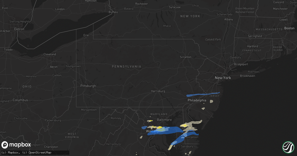
Hail Map in Pennsylvania on July 1, 2021
Get this storm
July 1 map
$229
one time, instant access
Download today. No call, no setup
Keep the $229
Bought the map and want the full workflow? Apply the entire $229 to a subscription within 7 days. None of it is wasted.
Every map, not just this one
This buys you this map. Subscription and you get every map we run, in the markets you choose from a few cities to whole states to nationwide. Plus real-time alerts the moment a storm fires.
Contact data
Name, contact info, occupancy, even credit band for addresses in the footprint. You go from where it hit to who to call.
Become the source they trust
Unlimited branding weather history reports on demand. You already have the documented answer ready for the property owner, and you are the one who showed up with it.
Property data and RoofTrace estimates
Pull up any address you have got, its value and the exact code rules for that jurisdiction, straight from One Click Code. Then RoofTrace estimates the squares, pitch, and roof value, priced the way you price.
Storm reports in Pennsylvania
Pennsylvania
| Date | Description |
|---|---|
| 07/01/20213:59 PM CDT | Several reports of downed power lines near fairless hills. Time estimated from radar. |
| 07/01/20213:53 PM CDT | Several reports of downed tree limbs and wires in levittown. Time estimated from radar. |
| 07/01/20213:50 PM CDT | Tree down on u.s. Route 1. |
| 07/01/20213:48 PM CDT | Mping report of wind damage near jackson street. Time estimated from radar. |
| 07/01/20213:30 PM CDT | Downed tree on wires near the intersection of washington lane and pepper road. Time estimated from radar. |
| 07/01/20213:19 PM CDT | Downed trees and wires near turk road in doylestown. Time estimated from radar. |
| 07/01/20213:12 PM CDT | Downed tree limbs on joshua road near cedar grove road. Time estimated from radar. |
| 07/01/20213:00 PM CDT | Downed trees and wires on marshall bridge road in kennett square. Time estimate from radar. |
| 07/01/20212:59 PM CDT | Downed trees and wires near garfield park in lansdale. |
| 07/01/20212:51 PM CDT | Several reports of downed tree limbs and wires near valley forge and phoenixville. Time estimated from radar. |
| 07/01/20212:47 PM CDT | Downed wires near paradise valley nature area in downingtown. Time estimated from radar. |
| 07/01/20212:31 PM CDT | Downed wires near horseshoe trail. Time estimated from radar. |
| 07/01/20212:27 PM CDT | Downed tree on beaver run road. Time estimated from radar. |
| 07/01/20212:26 PM CDT | Downed trees and wires near valley station road in coatesville. Time estimated from radar. |
| 07/01/20212:23 PM CDT | Mping report of downed tree limbs and power lines near route 100. Time estimated from radar. |
| 07/01/20212:21 PM CDT | Downed wires near elm road. Time estimated from radar. |
| 07/01/20212:21 PM CDT | Downed tree on fisherville road. Time estimated from radar. |
| 07/01/20212:13 PM CDT | Downed tree on lammey road. Time estimated from radar. |
| 07/01/202111:40 AM CDT | Tree down blocking road. |
| 07/01/20217:22 AM CDT | At 1221 PM EDT, a severe thunderstorm was located near Aspers, moving east at 30 mph. HAZARD...60 mph wind gusts. SOURCE...Radar indicated. IMPACT...Expect damage to roofs, siding, and trees. Locations impacted include... York, Weigelstown, Shiloh, West York, Dillsburg, Lake Meade, Mount Holly Springs, Dover, York Springs, Franklintown, Lewisberry, Wellsville, Idaville, Gardners, Newberrytown and Ski Roundtop Ski Area.This includes Interstate 83 from mile markers 25 to 32. |
| 06/30/202111:59 PM CDT | At 459 PM EDT, severe thunderstorms were located along a line extending from Pennington to near Woodstown, moving east at 30 mph. HAZARD...60 mph wind gusts. SOURCE...Radar indicated. IMPACT...Damage to roofs, siding, trees, and power lines is possible. Locations impacted include... Philadelphia, Trenton, Camden, Gloucester City, Cherry Hill, Old Bridge, Bensalem, East Brunswick, Evesham, South Brunswick, Mount Laurel, Ewing, Willingboro, Deptford, Voorhees, Medford, Glassboro, Lindenwold, Lumberton and Princeton.This includes the following highways... New Jersey Turnpike between exits 3 and 9. Pennsylvania Turnpike between mile markers 351 and 359. Interstate 95 in Pennsylvania between mile markers 29 and 40. Interstate 76 in New Jersey between mile markers 0 and 2. Interstate 195 in New Jersey between mile markers 0 and 12. Interstate 295 in New Jersey between mile markers 25 and 76. Interstate 676 in New Jersey near mile marker 0. Atlantic City Expressway between mile markers 30 and 44. |
| 06/30/202110:13 PM CDT | At 313 PM EDT, severe thunderstorms were located along a line extending from Bechtelsville to Glenmoore to near Quarryville, moving east at 35 mph. HAZARD...60 mph wind gusts. SOURCE...Radar indicated. IMPACT...Damage to roofs, siding, trees, and power lines is possible. Locations impacted include... West Chester, Pottstown, Phoenixville, Lansdale, West Norriton, East Norriton, Coatesville, Quakertown, Perkasie, Downingtown, Souderton, Bedminster, Kennett Square, Birdsboro, Collegeville, Oxford, Royersford, Parkesburg, Trappe and Hatfield.This includes the following highways... Pennsylvania Turnpike between mile markers 299 and 326. Northeast Extension between mile markers 25 and 47. |
| 06/30/20218:15 PM CDT | At 115 PM EDT, a severe thunderstorm was located over Manchester, moving east at 30 mph. HAZARD...60 mph wind gusts. SOURCE...Radar indicated. IMPACT...Expect damage to roofs, siding, and trees. This severe thunderstorm will be near... York, Mount Wolf, Manchester, Valley View and Grantley around 120 PM EDT. Bainbridge, Hallam, Yorklyn, Stonybrook-Wilshire, East York and Tyler Run-Queens Gate around 130 PM EDT. Mount Joy, Wrightsville, Marietta, Maytown, Yorkana and Rheems around 140 PM EDT. Columbia, Mountville and Salunga-Landisville around 150 PM EDT.Other locations impacted by this severe thunderstorm include YorkHaven, Washington Boro, East Prospect, Newberrytown, York College OfPennsylvania and Penn State York.This includes Interstate 83 from mile markers 14 to 32. |
All States Impacted by Hail Map on July 1, 2021
Cities Impacted by Hail Map on July 1, 2021
- Roggen, CO
- Laramie, WY
- Hugoton, KS
- Manchester Township, NJ
- Vincentown, NJ
- Chatsworth, NJ
- Browns Mills, NJ
- Cheyenne, WY
- Greeley, CO
- Medford, NJ
- Cottonwood, ID
- Esmont, VA
- Howardsville, VA
- Pemberton, NJ
- Pocomoke City, MD
- Clarksburg, MD
- Damascus, MD
- Gaithersburg, MD
- Germantown, MD
- Elbert, CO
- Greenbelt, MD
- Crofton, MD
- Crownsville, MD
- Brentwood, MD
- Upper Marlboro, MD
- Capitol Heights, MD
- Hyattsville, MD
- Annapolis, MD
- Bowie, MD
- College Park, MD
- Davidsonville, MD
- Glenn Dale, MD
- Beltsville, MD
- Lanham, MD
- Riverdale, MD
- Odenton, MD
- Riva, MD
- Laurel, MD
- Edgewater, MD
- Bladensburg, MD
- Gambrills, MD
- Washington, DC
- Avondale, CO
- Boone, CO
- Pueblo, CO
- Kim, CO
- Rice, VA
- Farmville, VA
- Chesterfield, VA
- Chester, VA
- Petersburg, VA
- Colonial Heights, VA
- Great Falls, VA
- Garrett Park, MD
- Kensington, MD
- Potomac, MD
- Rockville, MD
- Silver Spring, MD
- Bethesda, MD
- Centreville, MD
- Ingleside, MD
- Magnolia, DE
- Goldsboro, MD
- Henderson, MD
- Camden Wyoming, DE
- Marydel, DE
- Hartly, DE
- Felton, DE
- Marydel, MD
- Barclay, MD
- Dover, DE
- Mclean, TX
- Dickerson, MD
- Boyds, MD
- Barnesville, MD
- Windsor, CO
- Kiowa, CO
- Turkey, TX
- Garrett, WY
- Watkins, CO
- Bennett, CO
- Casper, WY
- Hoffman, NC
- Wagram, NC
- Marston, NC
- Aberdeen, NC
- Chevy Chase, MD
- Grangeville, ID
- Polebridge, MT
- Fowler, CO
- Millville, NJ
- Fountain, CO
- Cambridge, MD
- Taylors Island, MD
- Lexington Park, MD
- Woolford, MD
- Church Creek, MD
- Patuxent River, MD
- Madison, MD
- Yoder, WY
- Calhan, CO
- Polson, MT
- Charles City, VA
- Haines, OR
- Corvallis, MT
- Raeford, NC
- Pinebluff, NC
- Frederica, DE
- Wheatland, WY
- Prairie City, OR
- Shawnee, OK
- Spotsylvania, VA
- Greenwood, DE
- Bridgeville, DE
- Mineral, VA
- Fort George G Meade, MD
- Delmont, NJ
- Cabin John, MD
- Glen Echo, MD
- Mount Rainier, MD
- Harwood, MD
- McLean, VA
- Arlington, VA
- Lake George, CO
- Viola, DE
- Woodside, DE
- Church Hill, MD
- Heislerville, NJ
- Leesburg, NJ
- Dover Afb, DE
- Port Norris, NJ
- Seaford, DE
- Federalsburg, MD
- Dorchester, NJ
- Harrington, DE
- Newport, NJ
- Houston, DE
- Denton, MD
- Milford, DE
- Greensboro, MD
- Waterford Works, NJ
- Williamstown, NJ
- Sicklerville, NJ
- Hammonton, NJ
- Bonner, MT
- Hopewell, VA
- Kalispell, MT
- Morral, OH
- Harpster, OH
- Upper Sandusky, OH
- Mount Airy, MD
- Okarche, OK
- Rocky Mount, VA
- Rocky Ford, CO
- Model, CO
- Heathsville, VA
- Burgess, VA
- Reedville, VA
- Kaycee, WY
- Clarendon, TX
- Hurlock, MD
- Providence Forge, VA
- Whitefish, MT
- Nokesville, VA
- Catlett, VA
- Westover, MD
- Dry Fork, VA
- Danville, VA
- Chatham, VA
- Agate, CO
- Deer Trail, CO
- Snow Hill, MD
- Vass, NC
- Broadway, NC
- Cameron, NC
- Sanford, NC
- Lillington, NC
- Leesburg, VA
- Sterling, VA
- Ashburn, VA
- Aldie, VA
- Queen Anne, MD
- Annandale, VA
- Mcdaniel, MD
- Alexandria, VA
- Fairfax, VA
- Arnold, MD
- Ridgely, MD
- Fairfax Station, VA
- Claiborne, MD
- Saint Michaels, MD
- Andrews Air Force Base, MD
- Queenstown, MD
- Severna Park, MD
- Grasonville, MD
- District Heights, MD
- Rock Hall, MD
- Clifton, VA
- Cordova, MD
- Springfield, VA
- Shady Side, MD
- Falls Church, VA
- Wye Mills, MD
- Galesville, MD
- Suitland, MD
- Hillsboro, MD
- Stevensville, MD
- West River, MD
- Lothian, MD
- Fort Washington, MD
- Burke, VA
- Easton, MD
- Naval Anacost Annex, DC
- Deale, MD
- Oxon Hill, MD
- Churchton, MD
- Temple Hills, MD
- Fort Myer, VA
- Chester, MD
- Prince George, VA
- Secretary, MD
- Rhodesdale, MD
- Lincoln, DE
- Milton, DE
- East New Market, MD
- Trappe, MD
- Preston, MD
- Linkwood, MD
- Ellendale, DE
- Lewes, DE
- Vienna, MD
- Cullen, VA
- Charlotte Court House, VA
- Pamplin, VA
- Green Bay, VA
- Keysville, VA
- Meherrin, VA
- Mont Clare, PA
- Chester Springs, PA
- Wayne, PA
- Collegeville, PA
- Hatboro, PA
- Levittown, PA
- Bensalem, PA
- Bordentown, NJ
- Howell, NJ
- Huntingdon Valley, PA
- Willow Grove, PA
- Millstone Township, NJ
- Oaks, PA
- Dresher, PA
- Bridgeport, PA
- King Of Prussia, PA
- Robbinsville, NJ
- Bryn Athyn, PA
- Norristown, PA
- Freehold, NJ
- Abington, PA
- Langhorne, PA
- Horsham, PA
- Plymouth Meeting, PA
- Trenton, NJ
- Blue Bell, PA
- Cream Ridge, NJ
- Chesterfield, NJ
- Farmingdale, NJ
- Allentown, NJ
- Phoenixville, PA
- Fort Washington, PA
- Morrisville, PA
- Feasterville Trevose, PA
- Bristol, PA
- Fairless Hills, PA
- Southampton, PA
- Malvern, PA
- Ambler, PA
- Flourtown, PA


