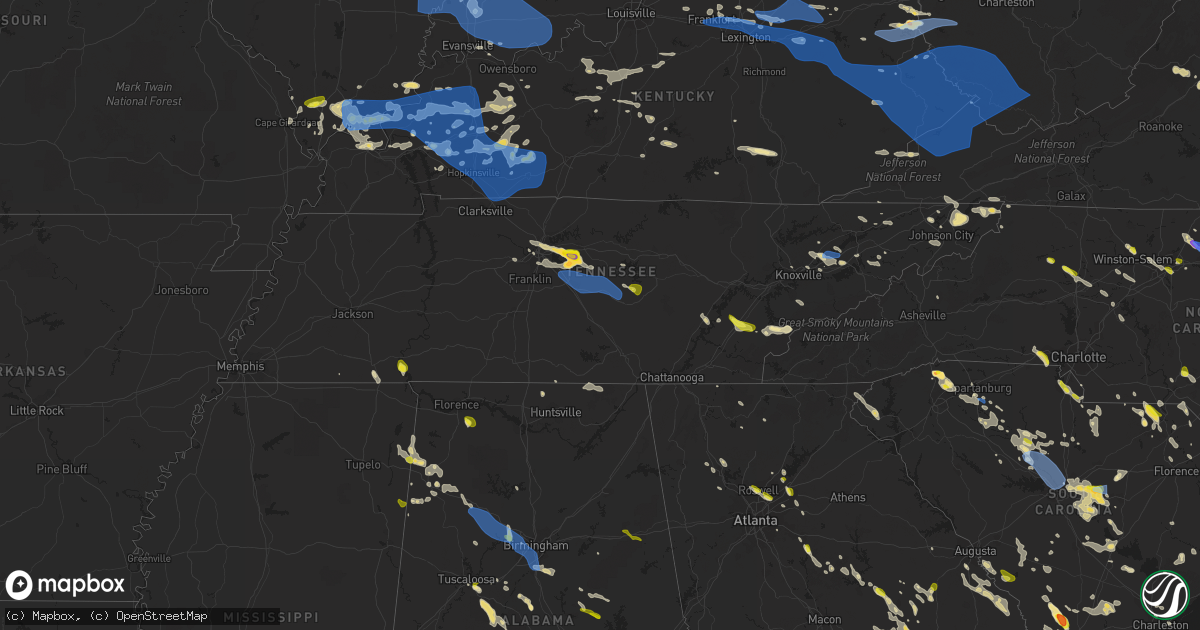
Hail Map in Tennessee on June 17, 2022
Get this storm
June 17 map
$229
one time, instant access
Download today. No call, no setup
Keep the $229
Bought the map and want the full workflow? Apply the entire $229 to a subscription within 7 days. None of it is wasted.
Every map, not just this one
This buys you this map. Subscription and you get every map we run, in the markets you choose from a few cities to whole states to nationwide. Plus real-time alerts the moment a storm fires.
Contact data
Name, contact info, occupancy, even credit band for addresses in the footprint. You go from where it hit to who to call.
Become the source they trust
Unlimited branding weather history reports on demand. You already have the documented answer ready for the property owner, and you are the one who showed up with it.
Property data and RoofTrace estimates
Pull up any address you have got, its value and the exact code rules for that jurisdiction, straight from One Click Code. Then RoofTrace estimates the squares, pitch, and roof value, priced the way you price.
Storm reports in Tennessee
Tennessee
| Date | Description |
|---|---|
| 06/17/20223:15 PM CDT | Multiple trees down. |
| 06/17/20223:09 PM CDT | Multiple trees down. |
| 06/17/20222:30 PM CDT | Several trees down. |
| 06/17/20222:30 PM CDT | Several trees down. Time estimated by radar. |
| 06/17/20222:05 PM CDT | Report of multiple trees down in the area with time estimated from radar. |
| 06/17/20222:05 PM CDT | Several trees down. |
| 06/17/20221:57 PM CDT | Social media photo of a 1 inch hailstone with the time being estimated from radar. |
| 06/17/20221:30 PM CDT | Several trees down. |
| 06/17/20221:29 PM CDT | Several trees down... Wind damage to a shed on property. |
| 06/17/20221:20 PM CDT | Multiple trees and power lines down county wide. Time estimated from radar. |
| 06/17/20221:14 PM CDT | Trees down across bugtussel road just south of the southern end of e clark and bugtussel road. |
| 06/17/20221:10 PM CDT | Trees down in jefferson city time estimated by radar. |
| 06/17/20221:00 PM CDT | Several trees down. |
| 06/17/202212:13 PM CDT | A local report indicates 1.00 inch wind near 3 N PICKWICK DAM |
| 06/17/202211:57 AM CDT | Report from mping: 1-inch tree limbs broken; shingles blown off. |
| 06/17/202211:45 AM CDT | Tree partly snapped on buzzard roost rd. |
| 06/17/202211:45 AM CDT | Corrects previous tstm wnd dmg report from 5 nw jamestown. Tree snapped on buzzard roost rd. |
| 06/17/202211:17 AM CDT | Trees down and power outages across the county. |
| 06/17/202211:01 AM CDT | Report from mping: 1-inch tree limbs broken; shingles blown off. |
| 06/17/202211:00 AM CDT | Tree fell onto and damaged a house on new salem hwy. |
| 06/17/202211:00 AM CDT | Report from mping: 1-inch tree limbs broken; shingles blown off. |
| 06/17/202210:59 AM CDT | 53 knots / 61 mph wind gust measured at murfreesboro airport awos. |
| 06/17/202210:57 AM CDT | Report from mping: baseball |
| 06/17/202210:53 AM CDT | 45 knots / 52 mph wind gust measured at smyrna airport awos. |
| 06/17/202210:53 AM CDT | 3 large trees down. |
| 06/17/202210:44 AM CDT | Tree in road on main street near maury hill. |
| 06/17/202210:44 AM CDT | Power line down. |
| 06/17/202210:42 AM CDT | Corrects previous hail report from 5 se belinda city. Ping pong to tea cup size hail in gladeville. Average hail stone size was lime to tennis ball. |
| 06/17/202210:42 AM CDT | Ping pong to lime size hail in gladeville. |
| 06/17/202210:41 AM CDT | Report from mping: 1-inch tree limbs broken; shingles blown off. |
| 06/17/202210:40 AM CDT | Tspotter report and photo showed 3 power poles down at forest lane and hampton drive. |
| 06/17/202210:38 AM CDT | Multiple reports of quarter to golf ball size hail in mount juliet and near pine creek golf course. |
| 06/17/202210:37 AM CDT | Tree down blocking nolensville road at williamson road. |
| 06/17/202210:37 AM CDT | Report from mping: ping pong ball |
| 06/17/202210:30 AM CDT | Report from mping: 3-inch tree limbs broken; power poles broken. |
| 06/17/202210:30 AM CDT | Roof damage to home and tree limbs down on gilbert drive. |
| 06/17/202210:28 AM CDT | Report from mping: trees uprooted or snapped. |
| 06/17/202210:26 AM CDT | Report from mping: 1-inch tree limbs broken; shingles blown off. |
| 06/17/202210:26 AM CDT | Report from mping: 1-inch tree limbs broken; shingles blown off. Kanawha |
| 06/17/202210:25 AM CDT | Several trees down in brentwood. |
| 06/17/202210:23 AM CDT | Tspotter report and photo of a large tree snapped in crieve hall. |
| 06/17/202210:20 AM CDT | Numerous tree branches and some trees down in the belle meade and oak hill areas. |
| 06/17/202210:18 AM CDT | Trees down in parking lot of summit hospital. |
| 06/17/202210:17 AM CDT | Tree split on 21st avenue between linden ave and sunset pl. |
| 06/17/202210:15 AM CDT | Trees down blocking roadways and power outages in the fairview... Leipers fork and grassland areas. |
| 06/17/202210:13 AM CDT | Report from mping: 1-inch tree limbs broken; shingles blown off. |
| 06/17/202210:10 AM CDT | Tspotter photo of quarter size hail in inglewood. |
| 06/17/202210:09 AM CDT | Tree down in donelson between two rivers pkwy and lebanon pike. |
| 06/17/202210:08 AM CDT | *** 1 inj *** women pinned underneath fallen tree in the 600 block of lucas road. Unknown injuries. |
| 06/17/202210:03 AM CDT | Tree down. |
| 06/17/202210:01 AM CDT | Corrects previous tstm wnd dmg report from 2 wsw inglewood. Twitter photo showed tree... Power line and power pole down blocking queen ave. |
| 06/17/202210:01 AM CDT | Twitter photo showed tree down blocking queen ave. |
| 06/17/20229:58 AM CDT | Tree down. |
| 06/17/20229:57 AM CDT | 50 ft tree snapped in joelton. |
| 06/17/20229:53 AM CDT | Tree down on clarksville pike at new hope rd. |
| 06/17/20229:51 AM CDT | Report from mping: 1-inch tree limbs broken; shingles blown off. |
| 06/17/20229:50 AM CDT | Numerous trees and power lines down across the county with widespread power outages... Mostly in the northwest part of the county. |
| 06/17/20229:45 AM CDT | Storm chaser reported 60 mph winds and trees down in springfield. |
| 06/17/20229:45 AM CDT | Widespread trees and power lines down across the county. |
| 06/17/20229:30 AM CDT | Tspotter twitter reports of several trees down and numerous power outages in clarksville. |
| 06/17/20229:24 AM CDT | 54 knots / 63 mph wind gust measured at clarksville outlaw field asos. |
| 06/17/20227:55 AM CDT | At 1254 PM EDT, severe thunderstorms were located along a line extending from Maplesville to near Blue Heron, moving east at 45 mph. HAZARD...60 mph wind gusts and penny size hail. SOURCE...Radar indicated. IMPACT...Expect damage to roofs, siding, and trees. Locations impacted include... London, Williamsburg, Manchester, Whitley City, Julip, Fariston, Cumberland Falls S.P., Zion Hill, Goose Rock, Mount Victory and Bush. |
| 06/17/20227:31 AM CDT | At 1231 PM EDT, severe thunderstorms were located along a line extending from Burr to near Great Meadows Campsites, moving east at 45 mph. HAZARD...60 mph wind gusts and penny size hail. SOURCE...Radar indicated. IMPACT...Expect damage to roofs, siding, and trees. Locations impacted include... Somerset, London, Monticello, Mount Vernon, Whitley City, Science Hill, Burnside, Cains Store, Donaro, Robinet, Cumberland Falls S.P. and Co-Operative. |
| 06/17/20226:51 AM CDT | At 1150 AM CDT, a severe thunderstorm was located 11 miles west of Petersburg, or 12 miles northeast of Pulaski, moving southeast at 25 mph. HAZARD...60 mph wind gusts and quarter size hail. SOURCE...Radar indicated. IMPACT...Hail damage to vehicles is expected. Expect wind damage to roofs, siding, and trees. Locations impacted include... Fayetteville, Mulberry, Howell, Belleville, Mcburg, Coldwater, Harms, Mimosa, Camargo and Boonshill. |
| 06/17/20225:56 AM CDT | At 1056 AM CDT, severe thunderstorms were located along a line extending from 8 miles northeast of Walterhill to near Murfreesboro to 11 miles south of Nolensville, moving southeast at 40 mph. HAZARD...60 mph wind gusts and quarter size hail. SOURCE...Radar indicated. IMPACT...Hail damage to vehicles is expected. Expect wind damage to roofs, siding, and trees. Locations impacted include... Murfreesboro, Lebanon, Shelbyville, Woodbury, Smyrna, Watertown, Walterhill, Eagleville, Bell Buckle, Liberty, Auburntown, Lascassas, Christiana, Beechgrove, Fosterville, Triune, Cedars Of Lebanon State Park, Rover, Deason and Rockvale. |
| 06/17/20225:27 AM CDT | At 1026 AM CDT, severe thunderstorms were located along a line extending from Belinda City to 7 miles northwest of Thompson's Station to near Centerville, moving southeast at 40 mph. HAZARD...60 mph wind gusts. SOURCE...Radar indicated. IMPACT...Expect damage to roofs, siding, and trees. Locations impacted include... Murfreesboro, Franklin, Columbia, Lebanon, Centerville, Smyrna, Brentwood, La Vergne, Spring Hill, Mount Juliet, Nolensville, Forest Hills, Oak Hill, Thompson's Station, Walterhill, Rural Hill, Antioch, Belinda City, Eagleville and Primm Springs. |
| 06/17/20224:58 AM CDT | At 956 AM CDT, severe thunderstorms were located along a line extending from near Ashland City to near White Bluff to near McEwen, moving south at 60 mph. HAZARD...60 mph wind gusts. SOURCE...Radar indicated. IMPACT...Expect damage to roofs, siding, and trees. Locations impacted include... Franklin, Dickson, Ashland City, Centerville, Nashville, Brentwood, Nolensville, Forest Hills, Oak Hill, White Bluff, Belle Meade, Kingston Springs, Thompson's Station, Pegram, Burns, Fairview, Bellevue, Antioch, Joelton and Berry Hill. |
| 06/17/20224:42 AM CDT | At 942 AM CDT, a severe thunderstorm was located 9 miles north of Russellville, moving east at 40 mph. HAZARD...60 mph wind gusts and quarter size hail. SOURCE...Radar indicated. IMPACT...Hail damage to vehicles is expected. Expect wind damage to roofs, siding, and trees. This severe thunderstorm will remain over mainly rural areas of Logan, Simpson and southwestern Warren Counties, including the following locations... Insco, Spa, Epleys, Black Jack, Rich Pond, Crossroad, Cave Springs, Old Volney, Olmstead and Cooperstown. |
| 06/17/20223:47 AM CDT | At 847 AM CDT, severe thunderstorms were located along a line extending from 6 miles east of Nortonville to 7 miles southeast of Cobb to near Land Between The Lakes Area, moving southeast at 40 mph. HAZARD...60 mph wind gusts. SOURCE...Radar indicated. IMPACT...Expect damage to roofs, siding, and trees. Locations impacted include... Hopkinsville, Pembroke, Oak Grove, Fort Campbell and Guthrie.This includes the following highways... Interstate 24 in Kentucky between Mile Markers 76 and 92. Pennyrile Parkway between Mile Markers 1 and 6. |
| 06/16/202211:05 PM CDT | At 404 PM EDT, severe thunderstorms were located along a line extending from 7 miles north of Beech Mountain to 8 miles northwest of Newland, moving east at 25 mph. HAZARD...60 mph wind gusts and nickel size hail. SOURCE...Radar indicated. IMPACT...Expect damage to trees and power lines. Locations impacted include... Banner Elk, Elk Park, Beech Mountain In Avery County, Sugar Mountain, Seven Devils, Minneapolis and Grandfather Mountain State Park. |
| 06/16/202211:02 PM CDT | At 402 PM EDT, severe thunderstorms were located along a line extending from near Draper to near Whitetop, moving southeast at 50 mph. HAZARD...60 mph wind gusts. SOURCE...Radar indicated. IMPACT...Expect damage to roofs, siding, and trees. Locations impacted include... Galax... Hillsville... Independence... Fries... Mouth Of Wilson... Fancy Gap... and Whitetop. |
| 06/16/202210:26 PM CDT | At 325 PM EDT, a severe thunderstorm was located near Epworth, or near Ducktown, moving east at 30 mph. HAZARD...60 mph wind gusts and quarter size hail. SOURCE...Radar indicated. IMPACT...Hail damage to vehicles is expected. Expect wind damage to roofs, siding, and trees. Locations impacted include... Blue Ridge, Morganton, Mineral Bluff, Jones Mill, Higdon, Colwell, Loving, Epworth, Hurst, Culberson and Copperhill. |
| 06/16/202210:11 PM CDT | At 311 PM EDT, a severe thunderstorm was located over Gregory, or 12 miles north of Chatsworth, moving southeast at 20 mph. HAZARD...60 mph wind gusts and quarter size hail. SOURCE...Radar indicated. IMPACT...Hail damage to vehicles is expected. Expect wind damage to roofs, siding, and trees. Locations impacted include... Crandall, Conasauga Lake, Tennga, Sumac, Jones Mill, Cisco, Gregory and Cohutta Wilderness. |
| 06/16/202210:10 PM CDT | At 310 PM EDT, severe thunderstorms were located along a line extending from 8 miles south of Greeneville to 14 miles southeast of Newport, moving east at 25 mph. HAZARD...60 mph wind gusts and quarter size hail. SOURCE...Radar indicated. IMPACT...Minor hail damage to vehicles is expected. Expect wind damage to trees and power lines. Locations impacted include... Marshall, Mars Hill, Hot Springs, Faust, Allenstand, Walnut, Wolf Ridge, Spring Creek, Max Patch and Luck. |
| 06/16/202210:08 PM CDT | At 308 PM EDT, severe thunderstorms were located along a line extending from 14 miles south of Newport to 15 miles west of Robbinsville, moving east at 30 mph. HAZARD...60 mph wind gusts and quarter size hail. SOURCE...Radar indicated. IMPACT...Minor hail damage to vehicles is expected. Expect wind damage to trees and power lines. Locations impacted include... Robbinsville, Cherokee, Town Of Santeetlah, Smoky Mountains-Deep Creek, Smoky Mountains-Newfound Gap, Smoky Mountains-Fontana Area, Lake Santeetlah, Smoky Mountains-Balsam Mountain, Fontana Lake and Fontana Village. |
| 06/16/20229:59 PM CDT | At 259 PM EDT, severe thunderstorms were located along a line extending from 8 miles east of Eagleton Village to 11 miles east of Madisonville, moving east at 85 mph. HAZARD...60 mph wind gusts and quarter size hail. SOURCE...Radar indicated. IMPACT...Hail damage to vehicles is expected. Expect wind damage to roofs, siding, and trees. Locations impacted include... Sevierville, Gatlinburg, Pigeon Forge, Smoky Mountains-Newfound Gap, Smoky Mountains-Big Creek, Smoky Mountains-Twentymile Creek, Smoky Mountains-Fontana Area, Smoky Mountains-Balsam Mountain, Pittman Center and Townsend.This includes Interstate 40 in Tennessee near mile marker 451. |
| 06/16/20229:48 PM CDT | At 247 PM EDT, severe thunderstorms were located along a line extending from 8 miles east of White Pine to near Baneberry to 6 miles southwest of Newport, moving southeast at 30 mph. HAZARD...60 mph wind gusts and half dollar size hail. SOURCE...Radar indicated. IMPACT...Hail damage to vehicles is expected. Expect wind damage to roofs, siding, and trees. Locations impacted include... Newport, Parrottsville, Caney Branch, Del Rio, Bybee, Cedar Creek, Round Mountain, Camp Creek and Max Patch.This includes Interstate 40 in Tennessee between mile markers 430 and440. |
| 06/16/20229:17 PM CDT | At 217 PM EDT, a severe thunderstorm was located near Decatur, moving southeast at 35 mph. HAZARD...60 mph wind gusts and half dollar size hail. SOURCE...Radar indicated. IMPACT...Hail damage to vehicles is expected. Expect wind damage to roofs, siding, and trees. Locations impacted include... Athens, Sweetwater, Madisonville, Decatur, Etowah, Spring City, Englewood, Niota, Riceville and Peakland.This includes Interstate 75 in Tennessee between mile markers 41 and64. |
| 06/16/20229:16 PM CDT | At 214 PM EDT, a severe thunderstorm was located over Jefferson City, moving east at 30 mph. HAZARD...60 mph wind gusts and quarter size hail. SOURCE...Radar indicated. IMPACT...Hail damage to vehicles is expected. Expect wind damage to roofs, siding, and trees. Locations impacted include... Morristown, Jefferson City, Newport, Dandridge, White Pine, New Market, Baneberry, Bybee, Alpha and Piedmont.This includes the following highways... Interstate 40 in Tennessee between mile markers 412 and 439. Interstate 81 in Tennessee between mile markers 1 and 17. |
| 06/16/20228:51 PM CDT | At 150 PM EDT, severe thunderstorms were located along a line extending from Arthur to near Hutch, moving east at 60 mph. HAZARD...60 mph wind gusts and penny size hail. SOURCE...Radar indicated. IMPACT...Expect damage to roofs, siding, and trees. Locations impacted include... Harlan, Pineville, Middlesboro, Loyall, Evarts, Wallins Creek, Bobs Creek, Sandy Fork, Mary Alice, Chevrolet, Varilla and Coldiron. |
| 06/16/20228:45 PM CDT | At 145 PM EDT, a severe thunderstorm was located over Plainview, or near Maynardville, moving east at 30 mph. HAZARD...60 mph wind gusts and quarter size hail. SOURCE...Radar indicated. IMPACT...Hail damage to vehicles is expected. Expect wind damage to roofs, siding, and trees. Locations impacted include... Jefferson City, Dandridge, Plainview, New Market, Strawberry Plains, Blaine, Luttrell, House Mountain State Park, Piedmont and Mascot.This includes Interstate 40 in Tennessee between mile markers 412 and416. |
| 06/16/20228:38 PM CDT | At 137 PM EDT, a severe thunderstorm was located 7 miles west of Rogersville, moving southeast at 20 mph. HAZARD...60 mph wind gusts and quarter size hail. SOURCE...Radar indicated. IMPACT...Hail damage to vehicles is expected. Expect wind damage to roofs, siding, and trees. Locations impacted include... Rogersville, St. Clair, Kepler, McCloud, Romeo and Klondike. This includes Interstate 81 in Tennessee between mile markers 27 and31. |
| 06/16/20228:28 PM CDT | At 128 PM EDT, severe thunderstorms were located along a line extending from Ashers Fork to Wilkerson, moving east at 60 mph. HAZARD...60 mph wind gusts and penny size hail. SOURCE...Radar indicated. IMPACT...Expect damage to roofs, siding, and trees. Locations impacted include... Barbourville, Harlan, Pineville, Middlesboro, Loyall, Evarts, Wallins Creek, Bobs Creek, Sandy Fork, Varilla, Swan Lake and Coldiron. |
All States Impacted by Hail Map on June 17, 2022
Cities Impacted by Hail Map on June 17, 2022
- Eureka, MT
- Georgetown, KY
- Kalispell, MT
- Condon, MT
- Spencer, WV
- East Setauket, NY
- Island Falls, ME
- Smyrna Mills, ME
- Oakfield, ME
- Newcastle, WY
- Sweet Grass, MT
- Cut Bank, MT
- Hill City, SD
- Blue Creek, OH
- Stout, OH
- Elkview, WV
- Charleston, WV
- Kenna, WV
- Deadwood, SD
- Lead, SD
- Advent, WV
- Ripley, WV
- Walton, WV
- Gandeeville, WV
- Dandridge, TN
- Jefferson City, TN
- Evansville, IN
- Newburgh, IN
- Bardstown, KY
- Cadiz, KY
- Frankfort, KY
- Valier, MT
- Browning, MT
- Heart Butte, MT
- Liberty, WV
- Red House, WV
- Leon, WV
- Buffalo, WV
- Poca, WV
- Port Jefferson, NY
- Port Jefferson Station, NY
- Mount Sinai, NY
- Mount Zion, WV
- Vine Grove, KY
- Custer, KY
- Irvington, KY
- Cecilia, KY
- Guston, KY
- Rineyville, KY
- Mechanicsville, VA
- Hanover, VA
- Ashland, VA
- Hartfield, VA
- Davin, WV
- Acton, ME
- Lebanon, ME
- Hillsboro, KY
- Morehead, KY
- Foster, KY
- Augusta, KY
- Brooksville, KY
- Mount Lookout, WV
- Southside, WV
- Henderson, WV
- Lavalette, WV
- Owensboro, KY
- Utica, KY
- Nashville, NC
- Blackwater, VA
- Kyles Ford, TN
- Powellton, WV
- Kimberly, WV
- Wayne, WV
- Prichard, WV
- Louisa, KY
- Catlettsburg, KY
- Rush, KY
- Boonville, IN
- Skippers, VA
- Emporia, VA
- Luttrell, TN
- Powder Springs, TN
- Newsoms, VA
- Courtland, VA
- Whaleyville, MD
- Frankford, DE
- Berlin, MD
- Willards, MD
- Delmar, MD
- Showell, MD
- Delmar, DE
- Millsboro, DE
- Laurel, DE
- Bishopville, MD
- Ocean City, MD
- Parsonsburg, MD
- Pittsville, MD
- Fayetteville, TN
- Guin, AL
- Hamilton, AL
- Brilliant, AL
- Suwanee, GA
- Buford, GA
- Lancaster, SC
- Bennettsville, SC
- Wallace, SC
- McColl, SC
- Hamlet, NC
- East Point, KY
- Cerulean, KY
- Gracey, KY
- Hopkinsville, KY
- Diagonal, IA
- Lenox, IA
- Clearfield, IA
- Madisonville, KY
- Dawson Springs, KY
- Nebo, KY
- Hermitage, TN
- Watertown, TN
- Murfreesboro, TN
- Madison, TN
- La Vergne, TN
- Nashville, TN
- Brentwood, TN
- Lebanon, TN
- Smyrna, TN
- Old Hickory, TN
- Whites Creek, TN
- Antioch, TN
- Mount Juliet, TN
- Linton, IN
- Switz City, IN
- Lyons, IN
- New Durham, NH
- Vesuvius, VA
- Buena Vista, VA
- Lexington, VA
- Fairfield, VA
- Natural Bridge, VA
- Hurricane, WV
- Winfield, WV
- Lexington, KY
- Paris, KY
- Sadieville, KY
- Corinth, KY
- Julian, WV
- Foster, WV
- Ridgeview, WV
- Sheridan, WY
- Saluda, VA
- Locust Hill, VA
- Salt Lick, KY
- Patoka, IN
- Hazleton, IN
- Rogersville, TN
- Marion, KY
- Fredonia, KY
- Hurley, VA
- Fort Gay, WV
- Webbville, KY
- Hacker Valley, WV
- Centertown, KY
- Central City, KY
- Yale, VA
- White Plains, KY
- Elkton, KY
- Drakesboro, KY
- Greenville, KY
- Lewisburg, KY
- Sharon Grove, KY
- Crofton, KY
- Dunmor, KY
- Nortonville, KY
- Beech Creek, KY
- Belton, KY
- Russellville, KY
- Flemingsburg, KY
- Raphine, VA
- Pinewood, SC
- Summerton, SC
- Georgetown, DE
- Reed, KY
- Alkol, WV
- Monroe, VA
- Glasgow, VA
- Easton, ME
- Presque Isle, ME
- Shelbyville, KY
- Tomahawk, KY
- Natural Bridge Station, VA
- Wallingford, KY
- Evans, WV
- Given, WV
- Cottageville, WV
- Shelburn, IN
- Sullivan, IN
- Greensburg, KY
- Summersville, KY
- Hillsborough, NC
- Grand Chain, IL
- Sandy Hook, KY
- Elkfork, KY
- Blountville, TN
- Vest, KY
- Jackson, KY
- Hueysville, KY
- Spartanburg, SC
- Pauline, SC
- Lizemores, WV
- Sturgis, KY
- Cave In Rock, IL
- Shawneetown, IL
- Junction, IL
- Elizabethtown, IL
- Patriot, OH
- Gallipolis, OH
- Jarratt, VA
- Drewryville, VA
- Boykins, VA
- Capron, VA
- Providence, KY
- Salem, KY
- Clay, KY
- Livermore, KY
- Slaughters, KY
- Rumsey, KY
- Bremen, KY
- Dixon, KY
- Hanson, KY
- Island, KY
- Calhoun, KY
- Manitou, KY
- Sacramento, KY
- Battleboro, NC
- Castalia, NC
- Strawberry Plains, TN
- Tremont, MS
- Fulton, MS
- Golden, MS
- Vina, AL
- Red Bay, AL
- Scotland Neck, NC
- Halifax, NC
- Enfield, NC
- Salem, IN
- Sneedville, TN
- Thorn Hill, TN
- Sunburst, MT
- Newberry, SC
- Johnson City, TN
- Henderson, NC
- Essex, MT
- Portsmouth, OH
- Wheelersburg, OH
- Franklin Furnace, OH
- Ripley, OH
- South Charleston, WV
- Ireland, WV
- Harts, WV
- Princeton, KY
- Detroit, AL
- Madisonville, TN
- Norwich, CT
- Bozrah, CT
- Minford, OH
- Milton, NH
- Union, NH
- Equality, IL
- Gallipolis Ferry, WV
- Dover, KY
- South Portsmouth, KY
- South Shore, KY
- Falmouth, KY
- Princeton, IN
- Columbia Falls, MT
- Louisa, VA
- Cape May, NJ
- Wildwood, NJ
- Lynx, OH
- Chapmanville, WV
- Big Creek, WV
- Albion, IL
- West Salem, IL
- Dugger, IN
- Midway, KY
- Stamping Ground, KY
- Crane, IN
- Odon, IN
- Loogootee, IN
- Elnora, IN
- Stem, NC
- Olmsted, IL
- Ullin, IL
- Pulaski, IL
- Villa Ridge, IL
- Dongola, IL
- Delbarton, WV
- Sarah Ann, WV
- Gilbert, WV
- Omar, WV
- Helvetia, WV
- Pickens, WV
- Buffalo, KY
- Sonora, KY
- Magnolia, KY
- Upton, KY
- Hodgenville, KY
- Mount Sherman, KY
- Knoxville, TN
- Whitesville, KY
- Hartford, KY
- Ranger, WV
- Branchland, WV
- Mosheim, TN
- Waynesburg, KY
- Eubank, KY
- Amherstdale, WV
- Man, WV
- Summersville, WV
- Dixie, WV
- Victor, WV
- Drennen, WV
- Belva, WV
- Swiss, WV
- Ansted, WV
- Coxs Creek, KY
- Bloomfield, KY
- Clearmont, WY
- Buffalo, WY
- Decker, MT
- Birney, MT
- Stony Creek, VA
- Rocky Mount, NC
- Chapel Hill, NC
- Liberty Hill, SC
- Patrick, SC
- Society Hill, SC
- Cheraw, SC
- Morven, NC
- Chesterfield, SC
- Garland, NC
- Rural Hall, NC
- Pfafftown, NC
- Winston Salem, NC
- Newport, TN
- Bybee, TN
- Parrottsville, TN
- Creal Springs, IL
- New Burnside, IL
- Stonefort, IL
- Lawrenceville, GA
- Grayson, GA
- Loganville, GA
- Leighton, AL
- Wilson, NC
- Elm City, NC
- Midway, TN
- Beaverton, AL
- Clio, SC
- Metter, GA
- Twin City, GA
- Cobbtown, GA
- Cape Girardeau, MO
- McClure, IL
- Franklinton, NC
- Statesboro, GA
- Kodak, TN
- Vance, AL
- Union, SC
- Brent, AL
- Marion, AL
- Norway, SC
- Hartsville, SC
- Ledbetter, KY
- Kuttawa, KY
- Grand Rivers, KY
- Smithland, KY
- Bessemer City, NC
- Clover, SC
- Gastonia, NC
- Kings Mountain, NC
- Kingston, GA
- Brooklet, GA
- Fort Branch, IN
- Francisco, IN
- Round O, SC
- Cottageville, SC
- Ruffin, SC
- Walterboro, SC
- Sylacauga, AL
- Monticello, GA
- Parkton, NC
- Lumber Bridge, NC
- Saint Pauls, NC
- Raeford, NC
- Madison, GA
- Eatonton, GA
- Crisfield, MD
- Hallwood, VA
- Yemassee, SC
- Red Springs, NC
- Maxton, NC
- Evensville, TN
- Decatur, TN
- Oxford, MS
- Cameron, SC
- Saint Matthews, SC
- Harrison, GA
- Davisboro, GA
- Sandersville, GA
- Bartow, GA
- Columbiana, AL
- Chelsea, AL
- Helena, AL
- Pelham, AL
- Shaw, MS
- Boyle, MS
- Arp, TX
- Tyler, TX
- Eustace, TX
- Canton, TX
- Brunswick, GA
- Hortense, GA
- Waynesville, GA
- Talladega, AL
- Mitchell, GA
- Rock Island, TN
- Whatley, AL
- Grove Hill, AL
- Savannah, TN
- Gibson, GA
- Stryker, MT
- Cross, SC
- Holly Hill, SC
- Tellico Plains, TN
- Singer, LA
- Bonaire, GA
- Orangeburg, SC
- Santee, SC
- Elloree, SC
- Islandton, SC
- Moravian Falls, NC
- Wilkesboro, NC
- Orange, VA
- Vonore, TN
- Anna, IL
- Jonesboro, IL
- Havelock, NC
- Union Grove, NC
- Statesville, NC
- Paducah, KY
- West Paducah, KY
- Heath Springs, SC
- Atlanta, GA
- Peachtree Corners, GA
- Norcross, GA
- Moore, SC
- Dequincy, LA
- Niota, TN
- Athens, TN
- Sparta, GA
- Varnville, SC
- Hampton, SC
- Grady, AL
- Ramer, AL
- Pomaria, SC
- Whitmire, SC
- Brunson, SC
- Early Branch, SC
- Sulligent, AL
- Deatsville, AL
- Hackleburg, AL
- Andrews, SC
- McKenney, VA
- Morganfield, KY
- Meherrin, VA
- Victoria, VA
- Green Bay, VA
- Darlington, SC
- Nettleton, MS
- Rockingham, NC
- Ellerbe, NC
- Fort Mill, SC
- Waxhaw, NC
- Winnsboro, SC
- Great Falls, SC
- Peachland, NC
- Pembroke, NC
- Lumberton, NC
- Kershaw, SC
- Engelhard, NC
- Taylors, SC
- Greer, SC
- Randolph, AL
- Jemison, AL
- Dry Branch, GA
- Kathleen, GA
- Travelers Rest, SC
- Roswell, GA
- Marietta, GA
- Rockwell, NC
- Salisbury, NC
- Gold Hill, NC
- Lexington, NC
- Clemmons, NC
- Counce, TN
- Mantachie, MS
- Saltillo, MS
- Guntown, MS
- Ridge, MD
- Dameron, MD
- Scotland, MD
- Piney Point, MD
- Saint Inigoes, MD
- Temperanceville, VA
- Parksley, VA
- Mears, VA
- Bloxom, VA
- Sanford, VA
- Greenbush, VA
- Ellijay, GA
- Magnolia, NC
- Rose Hill, NC
- Crandall, GA
- Vanceboro, NC
- New Market, TN
- Cartersville, GA
- Blenheim, SC
- Berry, AL
- Columbus, MS
- Soperton, GA
- Sweetwater, TN
- Englewood, TN
- Walnut, MS
- Weogufka, AL
- Jacksonville, TX
- North Charleston, SC
- Charleston, SC
- Thomson, GA
- Blackville, SC
- Barnwell, SC
- Williston, SC
- Neeses, SC
- Frankston, TX
- Glenwood, GA
- Leland, MS
- Tuscaloosa, AL
- Sylvania, GA
- Waynesboro, GA
- Sardis, GA
- Blythe, GA
- Keysville, GA
- Hephzibah, GA
- Girard, GA
- Byron, GA
- Montezuma, GA
- Wrightsville, GA
- Selma, AL
- Sumter, SC
- Vernon, AL
- Dingess, WV
- Linden, AL
- Pennington, AL
- Sweet Water, AL
- Georgetown, SC
- Brierfield, AL
- Montevallo, AL
- Marbury, AL
- Elmore, AL
- Prattville, AL
- Pembroke, GA
- Fort Stewart, GA
- Ruther Glen, VA
- Doswell, VA
- Beaverdam, VA
- Natchez, MS
- Thomasville, AL
- Pine Hill, AL
- Rock Hill, SC
- Duncanville, AL
- Cottondale, AL
- Hazlehurst, GA
- Jackson, SC
- Tennille, GA
- Pinehurst, GA
- Byromville, GA
- Vienna, GA
- Covington, GA
- Mansfield, GA
- Buncombe, IL
- Bluff City, TN
- Elizabethton, TN
- Dalzell, SC
- Dublin, GA
- Quinton, AL
- Mulga, AL
- West Point, MS
- Hoffman, NC
- Marston, NC
- Birmingham, AL
- Troup, TX
- Ridgeville, SC
- Lane, SC
- Athens, TX
- Mount Sterling, KY
- Gattman, MS
- Caledonia, MS
- Patterson, GA
- Nahunta, GA
- Wolf Lake, IL
- Partridge, KY
- Wise, VA
- Eolia, KY
- Appalachia, VA
- Norton, VA
- Philpot, KY
- Estillfork, AL
- Scottsboro, AL
- Gatesville, NC
- Gates, NC
- Eure, NC
- Pollocksville, NC
- Pegram, TN
- Saint Charles, KY
- Dayton, TN
- Spring Hope, NC
- Powell, TN
- Arapahoe, NC
- Grantsboro, NC
- New Bern, NC
- Metropolis, IL
- Rosiclare, IL
- Cypress, IL
- Grantsburg, IL
- Simpson, IL
- Hampton, KY
- Vienna, IL
- Karnak, IL
- Belknap, IL
- Brookport, IL
- Golconda, IL
- Goreville, IL
- Jonesborough, TN
- Clarkson, KY
- Rydal, GA
- White, GA
- Advance, NC
- Enoree, SC
- Clinton, NC
- Alamo, GA
- McRae Helena, GA
- Greensboro, NC
- Whitsett, NC
- Winfield, AL
- Maryville, TN
- Walland, TN
- Burlington, NC
- Browns Summit, NC
- Reidsville, NC
- Gibsonville, NC
- Elon, NC
- Goose Creek, SC
- Lithonia, GA
- Carbon Hill, AL
- Nauvoo, AL
- Eldridge, AL
- Townley, AL
- Abbeville, GA
- Maysville, NC
- Toney, AL
- Harvest, AL
- Acworth, GA
- Dallas, GA
- Aiken, SC
- Kingstree, SC
- Kellyton, AL
- Goodwater, AL
- Mount Pleasant, SC
- Milledgeville, GA
- Windsor, SC
- Clyo, GA
- Olar, SC
- Fairfax, SC
- Ulmer, SC
- Warthen, GA
- Luverne, AL
- Stamps, AR
- Duncan, MS
- Reynolds, GA
- Nacogdoches, TX
- Darien, GA
- Townsend, GA
- Quitman, GA
- Bokeelia, FL
- Shady Valley, TN
- Mountain City, TN
- Avera, GA
- Stapleton, GA
- Louisville, GA
- Blaine, TN
- Mascot, TN
- Ramer, TN
- Somerset, KY
- Jackson, MO
- Burfordville, MO
- Hopkins, SC
- Wedgefield, SC
- Columbia, KY
- Bristol, TN
- High Point, NC
- Jamestown, NC
- Colfax, NC
- Kernersville, NC
- Hiddenite, NC
- Harmony, NC
- Cleveland, NC
- Olin, NC
- Laurel Bloomery, TN
- Cedar Grove, NC
- Mebane, NC
- Roxboro, NC
- Prospect Hill, NC
- Timberlake, NC
- Hurdle Mills, NC
- Delphia, KY
- Linefork, KY
- Whitesburg, KY
- Cumberland, KY
- Hallie, KY
- Clayton, GA
- Walhalla, SC
- Mountain Rest, SC
- Westminster, SC
- Seneca, SC
- Monroe, NC
- Wingate, NC
- Marshville, NC
- Cumming, GA
- Woodstock, AL
- Merryville, LA
- Bishopville, SC
- Camden, SC
- Rembert, SC
- Glendale, KY
- Boston, KY
- New Haven, KY
- Elizabethtown, KY
- Beulaville, NC
- Pink Hill, NC
- Kenansville, NC
- Richlands, NC
- Clifton Forge, VA
- Eagle Rock, VA
- Edmonton, KY
- Bonnieville, KY
- Cobbs Creek, VA
- Morristown, TN
- White Pine, TN
- Oak Ridge, MO
- Seabrook, SC
- Beaufort, SC
- Coosawhatchie, SC
- Sheldon, SC
- Ridgeland, SC
- Crandall, TX
- Greenville, SC
- Landrum, SC
- Conway, SC
- Buffalo, SC
- Jonesville, SC
- Lyons, GA
- Cobden, IL
- Eastview, KY
- Montgomery, AL
- Marshallville, GA
- Fort Valley, GA
- Tar Heel, NC
- Bladenboro, NC
- Cochran, GA
- Warner Robins, GA
- Perry, GA
- Hawkinsville, GA
- Denmark, SC
- Cordele, GA
- Lambert, MS
- Lugoff, SC
- Columbia, SC
- Eastover, SC
- Elgin, SC
- Gadsden, SC
- Blair, SC
- Pinetops, NC
- Fountain, NC
- Macclesfield, NC
- Lumber City, GA
- Talking Rock, GA
- Spencer, NC
- Bumpass, VA
- Partlow, VA
- Spotsylvania, VA
- Tiplersville, MS
- West Blocton, AL
- White Oak, NC
- Swainsboro, GA
- East Dublin, GA
- Duncan, SC
- Woodruff, SC
- Roebuck, SC
- Lowndesboro, AL
- Kingsport, TN
- Ruby, SC
- Jeffersonville, KY
- Richland, IN
- Elberfeld, IN
- Oakland City, IN
- Waterloo, OH
- Bristol, VA
- Garysburg, NC
- Jackson, NC
- Roanoke Rapids, NC
- Weldon, NC
- Middleton, TN
- Catawba, SC
- Lilburn, GA
- Prosperity, SC
- North, SC
- Seagoville, TX
- Starkville, MS
- Estill, SC
- White Oak, GA
- Waverly, GA
- London, KY
- Salyersville, KY
- East Glacier Park, MT
- Lansing, NC
- Campbellsville, KY
- Graham, KY
- Keavy, KY
- Ferguson, KY
- Rutledge, TN
- Talbott, TN
- Unionville, VA
- Aylett, VA
- Mineral, VA
- Manquin, VA
- Inez, KY
- Mcminnville, TN
- Smithville, TN
- Kermit, WV
- Lenore, WV
- Breeden, WV
- Holden, WV
- Logan, WV
- Chapin, SC
- Little Mountain, SC
- Todd, NC
- Zionville, NC
- Creston, NC
- Apex, NC
- Durham, NC
- Cary, NC
- Creedmoor, NC
- Oxford, NC
- Damascus, VA
- Clinton, SC
- Fairmont, NC
- Liberty, TN
- Greenwood Springs, MS
- Amory, MS
- Hamilton, MS
- Mount Croghan, SC
- Rougemont, NC
- Mount Vernon, GA
- Corinth, MS
- Guys, TN
- Blackstock, SC
- Carlisle, SC
- Benoit, MS
- Pageland, SC
- Mantee, MS
- Rochelle, GA
- Tarboro, NC
- Swanquarter, NC
- Newington, GA
- Crane Hill, AL
- Bremen, AL
- Pineland, SC
- Garfield, GA
- Barnardsville, NC
- Latta, SC
- Springfield, GA
- Eutawville, SC
- Moncks Corner, SC
- Bonneau, SC
- Rockledge, GA
- Lewisville, AR
- Collins, GA
- Dermott, AR
- Toomsboro, GA
- Valdosta, GA
- Hahira, GA
- Big Clifty, KY
- Leitchfield, KY
- Earlington, KY
- Corryton, TN
- Tamms, IL
- Monticello, KY
- Iuka, MS
- Woodleaf, NC
- Cooleemee, NC
- Jasper, TX
- Westfield, ME
- Polebridge, MT
- Iron Gate, VA
- West Columbia, SC
- Blythewood, SC
- Jenkinsville, SC
- Irmo, SC
- Shaw Afb, SC
- Walling, TN
- Shiloh, TN
- Alpharetta, GA
- Town Creek, AL
- Tuscumbia, AL
- Bessemer, AL
- Garner, NC
- Fuquay Varina, NC
- Butner, NC
- Morrisville, NC
- Youngsville, NC
- Bahama, NC
- Raleigh, NC
- Wake Forest, NC
- Leopold, IN
- Bone Gap, IL
- Chrisney, IN
- Stendal, IN
- Mount Carmel, IL
- Grayville, IL
- Evanston, IN
- Winslow, IN
- Browns, IL
- Spurgeon, IN
- Saint Anthony, IN
- Jasper, IN
- Lawrenceville, IL
- Ferdinand, IN
- Griffin, IN
- Velpen, IN
- Vincennes, IN
- Lynnville, IN
- Saint Meinrad, IN
- Saint Croix, IN
- Tell City, IN
- Troy, IN
- Petersburg, IN
- Bridgeport, IL
- Chandler, IN
- Birdseye, IN
- Haubstadt, IN
- Hawesville, KY
- Santa Claus, IN
- Bristow, IN
- Decker, IN
- Cynthiana, IN
- Holland, IN
- Poseyville, IN
- Saint Francisville, IL
- Branchville, IN
- Grandview, IN
- Dale, IN
- Lincoln City, IN
- Claremont, IL
- Dundas, IL
- Gentryville, IN
- Allendale, IL
- Parkersburg, IL
- Huntingburg, IN
- Bellmont, IL
- Calhoun, IL
- Sumner, IL
- Owensville, IN
- Otwell, IN
- Lamar, IN
- Tennyson, IN
- Lewisport, KY
- Olney, IL
- Rockport, IN
- Hardinsburg, IN
- Cannelburg, IN
- English, IN
- Washington, IN
- Orleans, IN
- Campbellsburg, IN
- French Lick, IN
- West Baden Springs, IN
- Montgomery, IN
- Milltown, IN
- Dubois, IN
- Paoli, IN
- Shoals, IN
- Marengo, IN
- Fredericksburg, IN
- Eddyville, IL
- Guthrie, KY
- Trenton, KY
- Eddyville, KY
- Sebree, KY
- Mortons Gap, KY
- Allensville, KY
- Burna, KY
- Morgantown, KY
- Adams, TN
- Clarksville, TN
- Oak Grove, KY
- Olmstead, KY
- Pembroke, KY
- Adairville, KY
- Auburn, KY
- Henlawson, WV
- Olympia, KY
- War, WV
- Verner, WV
- Banner, KY
- Grethel, KY
- South Williamson, KY
- Willis, VA
- Whitewood, VA
- Weeksbury, KY
- Eggleston, VA
- Bluefield, VA
- Leburn, KY
- Debord, KY
- Elkhorn City, KY
- Freeman, WV
- Iaeger, WV
- Versailles, KY
- Austinville, VA
- Parrott, VA
- Baisden, WV
- Harold, KY
- Belspring, VA
- Stollings, WV
- Staffordsville, KY
- Check, VA
- Pippa Passes, KY
- Lick Creek, KY
- Raven, VA
- Mousie, KY
- Brenton, WV
- Kyle, WV
- Staffordsville, VA
- Gunlock, KY
- Stanton, KY
- Rock, WV
- Hindman, KY
- Denniston, KY
- West Van Lear, KY
- Vansant, VA
- Deane, KY
- Canada, KY
- Hellier, KY
- Teaberry, KY
- Yolyn, WV
- Pembroke, VA
- Raven, KY
- Mallie, KY
- Betsy Layne, KY
- Auxier, KY
- Richlands, VA
- Floyd, VA
- Jesse, WV
- Langley, KY
- David, KY
- McAndrews, KY
- Newport, VA
- Winchester, KY
- Raysal, WV
- Varney, KY
- Lovely, KY
- Wheelwright, KY
- Wayland, KY
- Simon, WV
- Ashcamp, KY
- Forest Hills, KY
- Topmost, KY
- Phelps, KY
- Bramwell, WV
- Clear Fork, WV
- Royalton, KY
- Paynesville, WV
- Davy, WV
- Mize, KY
- McDowell, KY
- Bevinsville, KY
- Williamson, WV
- Maybeury, WV
- Draper, VA
- Breaks, VA
- Bypro, KY
- Elkhorn, WV
- Camp Creek, WV
- Nora, VA
- Neon, KY
- Fanrock, WV
- Hazel Green, KY
- Shelby Gap, KY
- Beaver, KY
- Dana, KY
- Jolo, WV
- Stopover, KY
- Cannel City, KY
- Belfry, KY
- Means, KY
- Rowe, VA
- Oceana, WV
- Switzer, WV
- Barren Springs, VA
- Steele, KY
- Robinson Creek, KY
- Wilsondale, WV
- Clinchco, VA
- Ransom, KY
- Haysi, VA
- Martin, KY
- Princeton, WV
- Regina, KY
- Grundy, VA
- Raccoon, KY
- Tram, KY
- Indian Valley, VA
- Jewell Ridge, VA
- Kegley, WV
- Pinsonfork, KY
- Copper Hill, VA
- Dema, KY
- Hagerhill, KY
- Fedscreek, KY
- Hardy, KY
- Beeson, WV
- Ivel, KY
- Chauncey, WV
- Pikeville, KY
- Pound, VA
- Ripplemead, VA
- Lackey, KY
- Mouthcard, KY
- Matheny, WV
- Eastern, KY
- Max Meadows, VA
- Salem, VA
- Elliston, VA
- Spanishburg, WV
- Dugspur, VA
- Swords Creek, VA
- Kimper, KY
- Clayhole, KY
- Glen Lyn, VA
- Crum, WV
- Herndon, WV
- Blacksburg, VA
- Minnie, KY
- Owingsville, KY
- Huddy, KY
- Oakwood, VA
- Hope, KY
- Switchback, WV
- Oil Springs, KY
- Glen Fork, WV
- Phyllis, KY
- Wellington, KY
- Ezel, KY
- Vancleve, KY
- Matewan, WV
- Kite, KY
- Riner, VA
- Big Rock, VA
- Wytheville, VA
- Melvin, KY
- Berwind, WV
- Lake, WV
- Bays, KY
- Davenport, VA
- Panther, WV
- Pocahontas, VA
- Tazewell, VA
- Radford, VA
- Narrows, VA
- McCarr, KY
- New Richmond, WV
- Jackhorn, KY
- Saulsville, WV
- Hiwassee, VA
- Bland, VA
- Pilot, VA
- Garrett, KY
- North Spring, WV
- Pilgrim, KY
- Shelbiana, KY
- Dunlow, WV
- Dwale, KY
- Bent Mountain, VA
- Stanville, KY
- Fancy Gap, VA
- Squire, WV
- Beauty, KY
- Pineville, WV
- North Tazewell, VA
- Shawsville, VA
- Peterstown, WV
- Elbert, WV
- Garner, KY
- Rousseau, KY
- Pilgrims Knob, VA
- Pecks Mill, WV
- Drift, KY
- Campton, KY
- Lyburn, WV
- Bandy, VA
- McRoberts, KY
- Virgie, KY
- Belcher, KY
- Stone, KY
- Honaker, VA
- Cleveland, VA
- Ikes Fork, WV
- Thelma, KY
- Clay City, KY
- Kimball, WV
- Frenchburg, KY
- Birchleaf, VA
- Montcalm, WV
- McClure, VA
- Mallory, WV
- West Liberty, KY
- Meally, KY
- Boons Camp, KY
- Rich Creek, VA
- Bastian, VA
- Mohawk, WV
- Ceres, VA
- Pine Top, KY
- Northfork, WV
- Sidney, KY
- Hillsville, VA
- Bim, WV
- Pearisburg, VA
- Athens, WV
- Dublin, VA
- Slade, KY
- Paintsville, KY
- Welch, WV
- Coeburn, VA
- Dante, VA
- Pulaski, VA
- Van Lear, KY
- Prestonsburg, KY
- Coal Mountain, WV
- Clintwood, VA
- Wharncliffe, WV
- Printer, KY
- Bee, VA
- Bluefield, WV
- Warfield, KY
- Williamsport, KY
- Allen, KY
- Lashmeet, WV
- Hanover, WV
- Anawalt, WV
- Woodlawn, VA
- Freeburn, KY
- Millstone, KY
- Cyclone, WV
- Christiansburg, VA
- Rocky Gap, VA
- Hi Hat, KY
- Majestic, KY
- Blue River, KY
- Jenkins, KY
- Matoaka, WV
- Falls Mills, VA
- Wyoming, WV
- Sharpsburg, KY
- Ewing, KY
- Carlisle, KY
- Moorefield, KY
- Blaine, KY
- Genoa, WV
- Lowmansville, KY
- East Lynn, WV
- Adams, KY
- Martha, KY
- Isonville, KY
- Readyville, TN
- Auburntown, TN
- Milton, TN
- Lascassas, TN
- Woodbury, TN
- Fairfield, AL
- Parrish, AL
- Cordova, AL
- Oakman, AL
- Jasper, AL
- Dolomite, AL
- Pleasant Grove, AL
- Adamsville, AL


