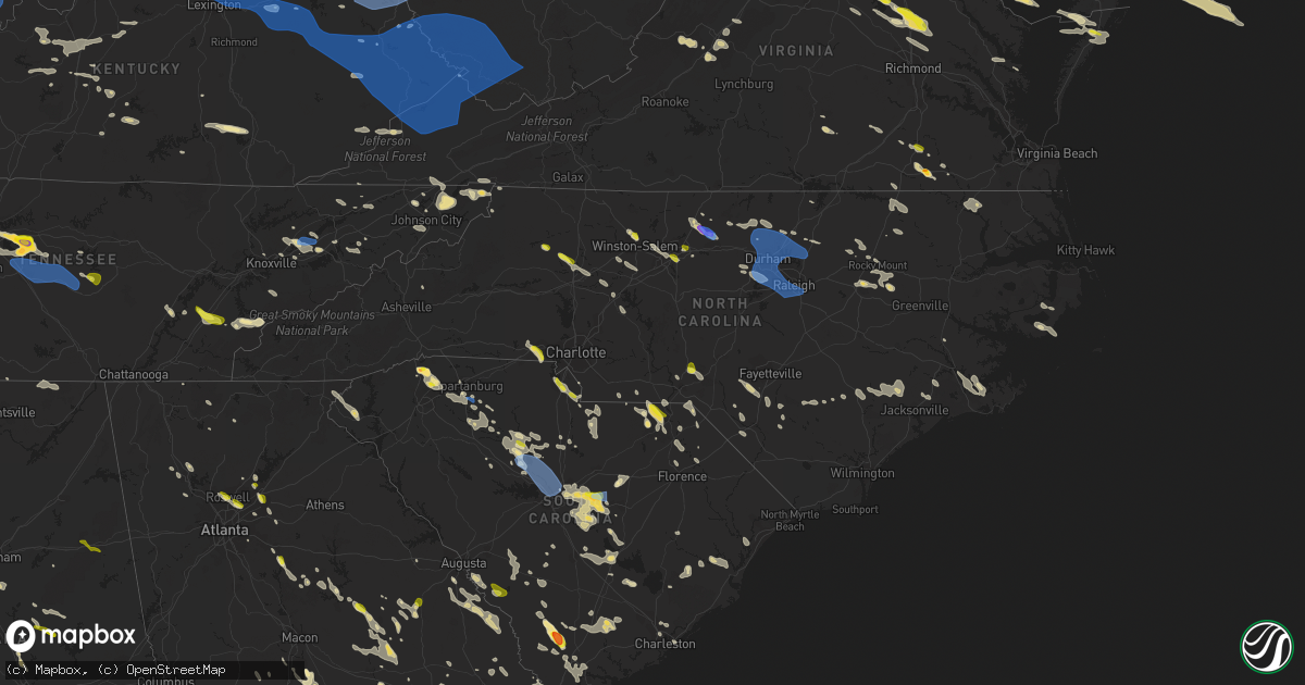
Hail Map in North Carolina on June 17, 2022
Get this storm
June 17 map
$229
one time, instant access
Download today. No call, no setup
Keep the $229
Bought the map and want the full workflow? Apply the entire $229 to a subscription within 7 days. None of it is wasted.
Every map, not just this one
This buys you this map. Subscription and you get every map we run, in the markets you choose from a few cities to whole states to nationwide. Plus real-time alerts the moment a storm fires.
Contact data
Name, contact info, occupancy, even credit band for addresses in the footprint. You go from where it hit to who to call.
Become the source they trust
Unlimited branding weather history reports on demand. You already have the documented answer ready for the property owner, and you are the one who showed up with it.
Property data and RoofTrace estimates
Pull up any address you have got, its value and the exact code rules for that jurisdiction, straight from One Click Code. Then RoofTrace estimates the squares, pitch, and roof value, priced the way you price.
Storm reports in North Carolina
North Carolina
| Date | Description |
|---|---|
| 06/17/20226:56 PM CDT | Radio reports tree down... Possibly blocking road on 264w near mile marker 55. |
| 06/17/20226:55 PM CDT | Reports of trees down... Time estimated by radar. |
| 06/17/20226:55 PM CDT | Trees downed along church street and highway 308. Time radar estimated. |
| 06/17/20226:54 PM CDT | Radio reports multiple trees down in bull head. Time estimated by radar. |
| 06/17/20226:50 PM CDT | Trained spotter reports large tree limbs down in association with gust front. |
| 06/17/20226:45 PM CDT | Reports of multiple trees down and shingles in road. Time estimated by radar. |
| 06/17/20226:40 PM CDT | Trees downed along sandy cross road and up river road. Time radar estimated. Report from social media. |
| 06/17/20226:30 PM CDT | Several trees and power lines down. |
| 06/17/20226:29 PM CDT | Tree on power lines at intersection of hooks river rd and us117 bypass. |
| 06/17/20226:26 PM CDT | Corrects time of previous tstm wnd dmg report from 1 e tarboro. Numerous trees and power lines down throughout edgecombe county. |
| 06/17/20226:25 PM CDT | Tree down blocking davis mill rd. |
| 06/17/20226:25 PM CDT | Half dollar-sized hail reported via facebook. |
| 06/17/20226:23 PM CDT | Power lines down at the intersection of camden and george owen. |
| 06/17/20226:23 PM CDT | Power lines down at the intersection of camden and crystal springs rd. |
| 06/17/20226:20 PM CDT | Tree blocking roadway. |
| 06/17/20226:15 PM CDT | 131 separate calls were received about trees down across the county. |
| 06/17/20226:15 PM CDT | Power lines down at the intersection of elk and cameron road. |
| 06/17/20226:10 PM CDT | Several trees and power lines down. |
| 06/17/20226:04 PM CDT | Powerline down across the roadway near rockingham. Time estimated by radar. |
| 06/17/20226:04 PM CDT | Tree down across the outside lane of i-95 south. Time estimated by radar. |
| 06/17/20226:00 PM CDT | Tree down in ellerbe along nc-73 hwy. |
| 06/17/20225:57 PM CDT | Tree down on residence along cherry street. Time estimated by radar. |
| 06/17/20225:53 PM CDT | Two trees down near the intersection of doc rd and long leaf dr. Time estimated by radar. |
| 06/17/20225:43 PM CDT | Two mobile homes damaged near louisburg. Time estimated by radar. |
| 06/17/20225:43 PM CDT | Large tree and power lines down along garner road. Time estimated by radar. |
| 06/17/20225:41 PM CDT | Tree down on retirement community building in garner. Time estimated by radar. |
| 06/17/20225:39 PM CDT | Extensive trees down and power outages being reported mainly across southern wake county. Some of hardest hit locations include fuquay-varina... Garner... And apex area |
| 06/17/20225:33 PM CDT | Very large tree down across blaney bluffs lane near lake wheeler. |
| 06/17/20225:31 PM CDT | *** 1 fatal *** a tree fell on and killed a person who was outside. |
| 06/17/20225:31 PM CDT | Storm damage occurred to a mobile home near franklinton. Time estimated by radar. |
| 06/17/20225:31 PM CDT | Tree down on a car along wild wood forest drive. Time estimated by radar. |
| 06/17/20225:28 PM CDT | *** 1 inj *** corrects previous tstm wnd dmg report from 3 sse cary. Tree fell on a car with occupant inside. No update on condition. Time estimated by radar. |
| 06/17/20225:28 PM CDT | Tree fell on a car with occupant inside. No update on condition. Time estimated by radar. |
| 06/17/20225:25 PM CDT | Tree down across the street near kingswood drive. Time estimated by radar. |
| 06/17/20225:24 PM CDT | Numerous trees and power lines down throughout moore county. |
| 06/17/20225:18 PM CDT | Many trees down across the southern portions of granville county... Including butner and creedmoor. Time is approximate. |
| 06/17/20225:14 PM CDT | Tree down blocking the left lane near mile marker 196 on i-85. Time estimated by radar. |
| 06/17/20225:10 PM CDT | Ktqv measured 55 kts at 6:10 pm. |
| 06/17/20225:06 PM CDT | Tree down on a garage on pervis road in durham. Time estimated by radar. |
| 06/17/20224:50 PM CDT | Tree fell on a residence. |
| 06/17/20224:45 PM CDT | Tree fell on a residence. |
| 06/17/20224:45 PM CDT | Tree fell on power line. |
| 06/17/20224:45 PM CDT | A tree fell on a residence. |
| 06/17/20224:42 PM CDT | Tree fell on a residence. |
| 06/17/20224:41 PM CDT | Tree down on a residence along alpha drive in mebane. Time estimated by radar. |
| 06/17/20224:40 PM CDT | Multiple trees down along i-85/40 near exit 157. |
| 06/17/20224:40 PM CDT | Multiple trees down in the granite quarry and rockwell area. |
| 06/17/20224:40 PM CDT | Several trees down near the spencer area. |
| 06/17/20224:38 PM CDT | Heavy damage to the roof of a house along e center street. Time estimated by radar. |
| 06/17/20224:36 PM CDT | Tree down on apartment building off of first street in mebane. |
| 06/17/20224:34 PM CDT | Emergency manager reports numerous trees across the northwestern... North-central... And eastern sections of the county. |
| 06/17/20224:31 PM CDT | Tree down along mill creek road. Time estimated by radar. |
| 06/17/20224:30 PM CDT | Tree down on road. |
| 06/17/20224:30 PM CDT | Multiple trees reported down and in roadways county wide... Most reports from about 5:30pm to 7:00pm. |
| 06/17/20224:25 PM CDT | A local report indicates 1.00 inch wind near 2 SW GASTONIA |
| 06/17/20224:20 PM CDT | Power lines down along chapel grove road and camp rotary road in gastonia. |
| 06/17/20224:17 PM CDT | Large tree down. |
| 06/17/20224:15 PM CDT | Large tree limbs down. |
| 06/17/20224:15 PM CDT | A local report indicates 1.00 inch wind near 3 ESE BESSEMER CITY |
| 06/17/20224:13 PM CDT | Tree on a residence off of pagetown road. |
| 06/17/20224:12 PM CDT | One tree down on flinchum farm road. |
| 06/17/20224:10 PM CDT | Tree down. |
| 06/17/20224:10 PM CDT | About 15 trees down and numerous power lines down across northern iredell county. |
| 06/17/20224:10 PM CDT | Trees down. |
| 06/17/20224:00 PM CDT | Trees down near johnson st and skeet club rd. |
| 06/17/20224:00 PM CDT | Multiple trees down around pilot mountain. |
| 06/17/20224:00 PM CDT | Report from mping: 3-inch tree limbs broken; power poles broken. |
| 06/17/20223:58 PM CDT | 911 call center reports power poles down near arcadia. Time estimated by radar. |
| 06/17/20223:58 PM CDT | Report from mping: trees uprooted or snapped; roof blown off. Time estimated from radar. |
| 06/17/20223:54 PM CDT | Several trees down. |
| 06/17/20223:53 PM CDT | Multiple trees down in mt airy. |
| 06/17/20223:43 PM CDT | Corrects previous tstm wnd dmg report from 3 wsw turnersburg. Trees down across i-77 south near mile marker 61 and mile marker 59 in northern iredell county. |
| 06/17/20223:42 PM CDT | Estimated 1 inch hail off of oak summit road in winston salem. Time estimated by radar. |
| 06/17/20223:38 PM CDT | Trees and power lines down. |
| 06/17/20223:38 PM CDT | Power lines down along friendship road. |
| 06/17/20223:38 PM CDT | Several large trees down in the maple chase country club neighborhood. Time estimated by radar. |
| 06/17/20223:31 PM CDT | A local report indicates 1.00 inch wind near 2 E LOVE VALLEY |
| 06/17/20223:30 PM CDT | Multiple trees down and power poles broken in sugar grove. |
| 06/17/20223:23 PM CDT | A local report indicates 1.00 inch wind near MORAVIAN FALLS |
| 06/17/20223:19 PM CDT | Multiple trees down in watauga county. |
| 06/17/20223:09 PM CDT | Trees down around the area. |
| 06/17/20223:05 PM CDT | Trees down in the area. |
| 06/17/20223:05 PM CDT | *** 1 fatal *** tree fell on a car at the biltmore estate. |
| 06/17/20223:05 PM CDT | Trees down in the nantahala national forest. |
| 06/17/20223:00 PM CDT | A few trees down in the area. |
| 06/17/20223:00 PM CDT | County dispatch reports trees down across cherokee county. |
| 06/17/20222:37 PM CDT | Two trees down. |
| 06/17/20222:30 PM CDT | Two trees down. |
| 06/17/20224:42 AM CDT | At 941 PM EDT, severe thunderstorms were located along a line extending from near Whortonsville to near Bogue to near Edgecomb, moving southeast at 25 mph. HAZARD...60 mph wind gusts and quarter size hail. SOURCE...Radar indicated. IMPACT...Hail damage to vehicles is expected. Expect wind damage to roofs, siding, and trees. Locations impacted include... Jacksonville, New Bern, Havelock, Morehead City, North Topsail Beach, Newport, Cedar Island, Harkers Island, Piney Green, New River Station, Camp Lejeune Center, Stella, Swansboro, Hubert, South River, Cape Carteret, North River, Davis, Straits and Atlantic. |
| 06/17/20224:06 AM CDT | At 906 PM EDT, a severe thunderstorm was located over Fort Landing, or 16 miles west of Stumpy Point, moving southeast at 55 mph. HAZARD...60 mph wind gusts and quarter size hail. SOURCE...Radar indicated. IMPACT...Hail damage to vehicles is expected. Expect wind damage to roofs, siding, and trees. Locations impacted include... Salvo, Avon, Buxton, Fort Landing and Avon Pier. |
| 06/17/20223:52 AM CDT | At 851 PM EDT, severe thunderstorms were located along a line extending from near Goose Creek State Park to near Askins to near Petersburg to near Penderlea, moving southeast at 40 mph. HAZARD...60 mph wind gusts and quarter size hail. SOURCE...Radar indicated. IMPACT...Hail damage to vehicles is expected. Expect wind damage to roofs, siding, and trees. Locations impacted include... Jacksonville, New Bern, Havelock, Washington, Morehead City, North Topsail Beach, Newport, Wallace, Cedar Island, Harkers Island, Pumpkin Center, New River Station, Half Moon, Camp Lejeune Center, Piney Green, James City, Trent Woods, River Bend, Stella and Swansboro. |
| 06/17/20223:46 AM CDT | At 845 PM EDT, severe thunderstorms were located along a line extending from near Penderlea to near Redbug to near Gresham, moving southeast at 45 mph. HAZARD...60 mph wind gusts. SOURCE...Radar indicated. IMPACT...Expect wind damage to trees and power lines. Locations impacted include... Conway, Leland, Marion, Whiteville, Mullins, Burgaw, Elizabethtown, Red Hill, Horry, Iredell, Rowan, Tabor City, Loris, Chadbourn, Bladenboro, Bethel, Johnsonville, Lake Waccamaw, Pamplico and Fair Bluff. |
| 06/17/20223:43 AM CDT | At 843 PM EDT, a severe thunderstorm was located 8 miles north of Alligator Lake, or 25 miles east of Plymouth, moving southeast at 25 mph. HAZARD...60 mph wind gusts and quarter size hail. SOURCE...Radar indicated. IMPACT...Hail damage to vehicles is expected. Expect wind damage to roofs, siding, and trees. Locations impacted include... Kilkenny and Killkenny. |
| 06/17/20223:30 AM CDT | At 830 PM EDT, a severe thunderstorm was located over Plymouth, moving southeast at 30 mph. HAZARD...60 mph wind gusts and quarter size hail. SOURCE...Radar indicated. IMPACT...Hail damage to vehicles is expected. Expect wind damage to roofs, siding, and trees. Locations impacted include... Plymouth, Ponzer, Pike Road, Wenona, Hinson, Leechville, Westover, Pleasant Grove, Scuppernong, Phelps Lake, Pungo Lake, Mackeys, Roper, Creswell and Dardens. |
| 06/17/20223:19 AM CDT | At 819 PM EDT, a severe thunderstorm was located near Columbia, or 20 miles south of Weeksville, moving southeast at 30 mph. HAZARD...60 mph wind gusts and quarter size hail. SOURCE...Radar indicated. IMPACT...Hail damage to vehicles is expected. Expect wind damage to roofs, siding, and trees. Locations impacted include... Alligator, Gum Neck, Mashoes, Manteo, Columbia, East Lake, Newfoundland, Buffalo City and Frying Pan Landing. |
| 06/17/20223:15 AM CDT | At 814 PM EDT, severe thunderstorms were located along a line extending from 9 miles northwest of Harrells to near Claussen, moving southeast at 35 mph. HAZARD...60 mph wind gusts. SOURCE...Radar indicated. IMPACT...Expect wind damage to trees and power lines. Locations impacted include... Marion, Whiteville, Mullins, Elizabethtown, Horry, Rowan, Tabor City, Loris, Chadbourn, Bladenboro, Lake Waccamaw, Johnsonville, Pamplico, Fair Bluff, Lake View, Sandyfield, Boardman, Penderlea, Point Caswell and Hallsboro. |
| 06/17/20223:14 AM CDT | At 814 PM EDT, severe thunderstorms were located along a line extending from near Rose Hill to 8 miles southeast of Ammon, moving south at 30 mph. HAZARD...60 mph wind gusts. SOURCE...Radar indicated. IMPACT...Expect damage to roofs, siding, and trees. Locations impacted include... Harrells, Garland and Ivanhoe. |
| 06/17/20223:12 AM CDT | At 812 PM EDT, a severe thunderstorm was located near Robersonville, or 7 miles southwest of Williamston, moving southeast at 55 mph. HAZARD...60 mph wind gusts. SOURCE...Radar indicated. IMPACT...Expect damage to roofs, siding, and trees. Locations impacted include... Washington, Williamston, Stokes, Belhaven, Pinetown, Ransomville, Pungo, Pamlico Beach, Pactolus, Bunyan, Leechville, Winsteadville, Sidney Crossroads, Terra Ceia, Yeatesville, Old Ford, Long Acre VFD, Sydney Crossroads, Smithwick and Pantego. |
| 06/17/20223:09 AM CDT | At 808 PM EDT, severe thunderstorms were located along a line extending from Pactolus to near Wyse Fork to near Kornegay to near Rose Hill, moving southeast at 45 mph. HAZARD...60 mph wind gusts. SOURCE...Radar indicated. IMPACT...Expect damage to roofs, siding, and trees. Locations impacted include... Greenville, Jacksonville, New Bern, Kinston, Washington, Ayden, Wallace, Pumpkin Center, New River Station, River Road, Half Moon, Camp Lejeune Center, Piney Green, James City, Trent Woods, River Bend, Stella, Swansboro, Grifton and Phillips Crossroads. |
| 06/17/20222:29 AM CDT | At 728 PM EDT, a severe thunderstorm was located 9 miles north of Tarboro, moving east at 45 mph. HAZARD...60 mph wind gusts. SOURCE...Radar indicated. IMPACT...Expect damage to roofs, siding, and trees. Locations impacted include... Washington, Williamston, Bethel, Stokes, Robersonville, Old Ford, Gold Point, Hamilton, Oak City, Smithwick, Parmele, Everetts, Hassell and Beargrass. |
| 06/17/20222:24 AM CDT | At 723 PM EDT, severe thunderstorms were located along a line extending from 7 miles southeast of Wilson to 6 miles northwest of Goldsboro to 12 miles southeast of Godwin, moving southeast at 50 mph. HAZARD...60 mph wind gusts. SOURCE...Radar indicated. IMPACT...Expect damage to roofs, siding, and trees. Locations impacted include... Greenville, Kinston, Washington, Winterville, Ayden, Farmville, Wallace, Warsaw, La Grange, Mount Olive, Grifton, Phillips Crossroads, Kornegay, Rose Hill, Snow Hill, Bell Arthur, Beulaville, Deep Run, House and Shelmerdine. |
| 06/17/20222:20 AM CDT | At 720 PM EDT, severe thunderstorms were located along a line extending from near Wilson to 13 miles northwest of Mount Olive to near Fayetteville to near Antioch, moving southeast at 45 mph. HAZARD...60 mph wind gusts. SOURCE...Public. There are widespread reports of trees and power lines down across this area. IMPACT...Expect damage to roofs, siding, and trees. Locations impacted include... Fayetteville, Goldsboro, Clinton, Wilson, Mount Olive, Elm City, Fremont, Walnut Creek, Harrells and Antioch. |
| 06/17/20222:08 AM CDT | At 708 PM EDT, a severe thunderstorm was located over Gatesville, moving southeast at 20 mph. HAZARD...60 mph wind gusts and quarter size hail. SOURCE...Radar indicated. IMPACT...Minor damage to vehicles is possible. Expect wind damage to trees and powerlines. This severe thunderstorm will be near... Harrellsville around 725 PM EDT. Ryland and Tyner around 745 PM EDT. Colerain around 750 PM EDT. Rockyhock around 755 PM EDT.Other locations impacted by this severe thunderstorm include GoosePond, Whites Crossroads, Tunis, Gliden, Newsome Store, ArrowheadBeach, Peach, Chowan Beach, Topsy and Buckland. |
| 06/17/20221:48 AM CDT | At 647 PM EDT, severe thunderstorms were located along a line extending from near Henderson to 14 miles north of Bunn to 6 miles east of Louisburg, moving east at 70 mph. HAZARD...70 mph wind gusts. SOURCE...Radar indicated. IMPACT...Expect considerable tree damage. Damage is likely to mobile homes, roofs, and outbuildings. Locations impacted include... Rocky Mount, Roanoke Rapids, Henderson, Tarboro, Nashville, Louisburg, Warrenton, Halifax, Scotland Neck and Franklinton. |
| 06/17/20221:40 AM CDT | At 640 PM EDT, severe thunderstorms were located along a line extending from near Louisburg to near Angier to 10 miles southeast of Sanford to near Pinehurst, moving southeast at 40 mph. HAZARD...70 mph wind gusts. SOURCE...Emergency management. At 610 PM, a 63 mph gust was measured northwest of Chapel Hill. IMPACT...Expect considerable tree damage. Damage is likely to mobile homes, roofs, and outbuildings. Locations impacted include... Raleigh, Fayetteville, Southern Pines, Smithfield, Raeford, Louisburg, Lillington, Fort Bragg, Wilson and Garner. |
| 06/17/20221:19 AM CDT | At 619 PM EDT, severe thunderstorms were located along a line extending from Spainville to near Dundas to near Norlina, moving east at 50 mph. HAZARD...60 mph wind gusts. SOURCE...Radar indicated. IMPACT...Expect damage to trees and powerlines. Severe thunderstorms will be near... Wilsons around 625 PM EDT. Alberta around 630 PM EDT. McKenney around 635 PM EDT. Sutherland and Dewitt around 640 PM EDT. Dinwiddie around 645 PM EDT.Other locations impacted by these severe thunderstorms includeCochran, Addison, Dolphin, Bowens Corner, Wharfs Store,Meredithville, Darvills, Church Road, Hebron and Edgerton. |
| 06/17/202212:58 AM CDT | At 557 PM EDT, the outflow from severe thunderstorms was located along a line extending from 8 miles north of Butner to near Carrboro to near Siler City to 10 miles northeast of Badin Lake, moving southeast at 45 mph. The cores of the thunderstorms remain slightly farther to the west. HAZARD...70 mph wind gusts. SOURCE...Emergency management. IMPACT...Expect considerable tree damage. Damage is likely to mobile homes, roofs, and outbuildings. Locations impacted include... Raleigh, Durham, Cary, Chapel Hill, Sanford, Southern Pines, Creedmoor, Pittsboro, Lillington and Troy. |
| 06/17/202212:57 AM CDT | At 556 PM EDT, a severe thunderstorm was located 4 miles north of Rock Hill, or near Tega Cay, moving southeast at 20 mph. HAZARD...60 mph wind gusts and quarter size hail. SOURCE...Radar indicated. IMPACT...Minor hail damage to vehicles is expected. Expect wind damage to trees and power lines. Locations impacted include... Rock Hill, Fort Mill, Tega Cay, Newport, Lesslie, Catawba and Lake Wylie. |
| 06/17/202212:50 AM CDT | At 550 PM EDT, severe thunderstorms were located along a line extending from near Hampden Sydney College to near Keysville to near Cluster Springs to Prospect Hill, moving southeast at 40 mph. HAZARD...60 mph wind gusts. SOURCE...Radar indicated. IMPACT...Expect damage to trees and powerlines. Severe thunderstorms will be near... Rehoboth around 605 PM EDT. Victoria and Lunenburg around 610 PM EDT. Kenbridge around 615 PM EDT. Dundas around 630 PM EDT. South Hill and La Crosse around 635 PM EDT. Brodnax around 640 PM EDT.Other locations impacted by these severe thunderstorms include BaconsFork, Wilburn, Spanish Grove, Gills Corner, Beechwood, Arvins Store,Finchley, Nutbush, Finneywood and Forksville. |
| 06/17/202212:40 AM CDT | At 540 PM EDT, a severe thunderstorm was located 4 miles east of Salisbury, or near Spencer, moving southeast at 25 mph. HAZARD...60 mph wind gusts and quarter size hail. SOURCE...Radar indicated. IMPACT...Minor hail damage to vehicles is expected. Expect wind damage to trees and power lines. Locations impacted include... Salisbury, Spencer, Granite Quarry, Rockwell, Mt Pleasant, Faith, High Rock Lake and Gold Hill. |
| 06/17/202212:34 AM CDT | At 534 PM EDT, severe thunderstorms were located along a line extending from near Roxboro to 8 miles south of Elon to near Salisbury, moving southeast at 30 mph. HAZARD...70 mph wind gusts and quarter size hail. SOURCE...Radar indicated. IMPACT...Hail damage to vehicles is expected. Expect considerable tree damage. Wind damage is also likely to mobile homes, roofs, and outbuildings. Locations impacted include... Durham, High Point, Chapel Hill, Burlington, Asheboro, Lexington, Albemarle, Graham, Oxford and Roxboro. |
| 06/17/202212:30 AM CDT | At 529 PM EDT, a severe thunderstorm was located 4 miles south of Gastonia, or near South Gastonia, moving southeast at 20 mph. HAZARD...60 mph wind gusts and quarter size hail. SOURCE...Radar indicated. IMPACT...Minor hail damage to vehicles is expected. Expect wind damage to trees and power lines. Locations impacted include... Gastonia, Central Charlotte, Southwest Charlotte, South Gastonia, Tega Cay, Cramerton, Charlotte Douglas Airport, Steele Creek, Carowinds and Lake Wylie. |
| 06/16/202211:58 PM CDT | At 458 PM EDT, a severe thunderstorm was located 6 miles southwest of Mocksville, moving southeast at 30 mph. HAZARD...60 mph wind gusts and quarter size hail. SOURCE...Radar indicated. IMPACT...Minor hail damage to vehicles is expected. Expect wind damage to trees and power lines. Locations impacted include... Mocksville, Cooleemee, Harmony, Turnersburg, Piedmont Research Station, Woodleaf, Cool Springs, Cleveland, Sheffield and Olin. |
| 06/16/202211:53 PM CDT | At 453 PM EDT, severe thunderstorms were located along a line extending from Reidsville to near Greensboro to 6 miles southeast of Clemmons to 8 miles southeast of Harmony, moving southeast at 40 mph. HAZARD...60 mph wind gusts and quarter size hail. SOURCE...Radar indicated. IMPACT...Hail damage to vehicles is expected. Expect wind damage to roofs, siding, and trees. Locations impacted include... Greensboro, Winston-Salem, High Point, Burlington, Lexington, Graham, Randleman, Thomasville, Kernersville and Clemmons. |
| 06/16/202211:40 PM CDT | At 436 PM EDT, severe thunderstorms were located along a line extending from near Rocky Mount Virginia to Wilkesboro North Carolina, moving southeast at 50 mph. Additional thunderstorms were developing ahead of this line, near Wentworth and Yadkinville, North Carolina. HAZARD...60 mph wind gusts and quarter size hail. SOURCE...Radar indicated. IMPACT...Hail damage to vehicles is expected. Expect wind damage to roofs, siding, and trees. Locations impacted include... Danville... Eden... Reidsville... Martinsville... Yadkinville... Wentworth... and Mayodan.This includes The following Locations The Martinsville Speedway,Martinsville Airport, and Danville Airport. |
| 06/16/202211:30 PM CDT | At 430 PM EDT, severe thunderstorms were located along a line extending from 12 miles southeast of Sylva to 9 miles north of Clayton, moving southeast at 30 mph. HAZARD...60 mph wind gusts and penny size hail. SOURCE...Radar indicated. IMPACT...Expect damage to trees and power lines. Locations impacted include... Franklin, Clayton, Highlands, Mountain City, Rosman, Dillard, Sky Valley, Cashiers, Lake Toxaway and Lake Glenville. |
| 06/16/202211:25 PM CDT | At 425 PM EDT, severe thunderstorms were located along a line extending from Stoneville to near Germanton to near Courtney, moving southeast at 25 mph. HAZARD...60 mph wind gusts and quarter size hail. SOURCE...Radar indicated. IMPACT...Hail damage to vehicles is expected. Expect wind damage to roofs, siding, and trees. Locations impacted include... Greensboro, Winston-Salem, High Point, Kernersville, Clemmons, Bermuda Run, Lewisville, Summerfield, Stokesdale and Walkertown. |
| 06/16/202211:13 PM CDT | At 413 PM EDT, a severe thunderstorm was located 11 miles southwest of Franklin, or 6 miles southeast of Nantahala Lake, moving east at 25 mph. HAZARD...60 mph wind gusts and nickel size hail. SOURCE...Radar indicated. IMPACT...Expect damage to trees and power lines. Locations impacted include... Otto, Rainbow Springs and Nantahala Lake. |
| 06/16/202211:09 PM CDT | At 409 PM EDT, a severe thunderstorm was located 6 miles southeast of Wilkesboro, or 4 miles southeast of Moravian Falls, moving southeast at 20 mph. HAZARD...60 mph wind gusts and quarter size hail. SOURCE...Radar indicated. IMPACT...Minor hail damage to vehicles is expected. Expect wind damage to trees and power lines. Locations impacted include... Stony Point, Harmony, Love Valley, Hiddenite, Turnersburg, Olin, Vashti, Union Grove, Scotts and Statesville. |
| 06/16/202211:07 PM CDT | At 406 PM EDT, severe thunderstorms were located along a line extending from Rugby to near Peoria, moving east at 40 mph. HAZARD...60 mph wind gusts and quarter size hail. SOURCE...Radar indicated. IMPACT...Hail damage to vehicles is expected. Expect wind damage to roofs, siding, and trees. Locations impacted include... North Wilkesboro... Wilkesboro... Sparta... Ronda... Traphill... Boomer... and Mc Grady. |
| 06/16/202211:00 PM CDT | At 400 PM EDT, a severe thunderstorm was located 6 miles north of Robbinsville, or near Fontana Village, moving southeast at 25 mph. HAZARD...60 mph wind gusts and nickel size hail. SOURCE...Radar indicated. IMPACT...Expect damage to trees and power lines. Locations impacted include... Robbinsville, Town Of Santeetlah, Fontana Village, Lake Santeetlah, Stecoah, Cheoah, Fontana Lake and Nantahala. |
| 06/16/202210:58 PM CDT | At 358 PM EDT, a severe thunderstorm was located near Nantahala Lake, or 7 miles east of Andrews, moving east at 35 mph. HAZARD...60 mph wind gusts and quarter size hail. SOURCE...Trained weather spotters. IMPACT...Hail damage to vehicles is expected. Expect wind damage to roofs, siding, and trees. Locations impacted include... Andrews, Hayesville, Nantahala Lake, Shooting Creek, Tusquitee, Topton, Marble and Brasstown. |
| 06/16/202210:57 PM CDT | At 357 PM EDT, a severe thunderstorm was located 9 miles northeast of Elizabethton, moving east at 35 mph. HAZARD...60 mph wind gusts and quarter size hail. SOURCE...Radar indicated. IMPACT...Hail damage to vehicles is expected. Expect wind damage to roofs, siding, and trees. Locations impacted include... Mountain City, Trade, Roane Mountain State Park, Doeville, Neva, Hampton Creek Cove State Park, Elk Mills, Shady Valley and Roan Mountain. |
| 06/16/202210:46 PM CDT | At 346 PM EDT, severe thunderstorms were located along a line extending from 5 miles northwest of Sylva to 3 miles northeast of Andrews, moving east at 35 mph. HAZARD...60 mph wind gusts and nickel size hail. SOURCE...Radar indicated. IMPACT...Expect damage to trees and power lines. Locations impacted include... Franklin, Sylva, Waynesville, Bryson City, Cherokee, Cullowhee, Balsam, Webster, Dillsboro and Graveyard Fields. |
| 06/16/202210:41 PM CDT | At 340 PM EDT, severe thunderstorms were located along a line extending from 4 miles south of Burnsville to 15 miles east of Marshall, moving southeast at 20 mph. HAZARD...60 mph wind gusts and nickel size hail. SOURCE...Radar indicated. IMPACT...Expect damage to trees and power lines. Locations impacted include... Marion, Burnsville, Black Mountain, Old Fort, Mount Mitchell State Park, B.R. Parkway-Craggy To Little Switzerland, Montreat, Nebo, Pleasant Gardens and Woodlawn. |
| 06/16/202210:21 PM CDT | At 321 PM EDT, a severe thunderstorm was located near Mountain City, moving southeast at 45 mph. HAZARD...60 mph wind gusts and quarter size hail. SOURCE...Radar indicated. IMPACT...Hail damage to vehicles is expected. Expect wind damage to roofs, siding, and trees. Locations impacted include... Mountain City and Laurel Bloomery. |
| 06/16/20229:52 PM CDT | At 252 PM EDT, a severe thunderstorm was located near Madisonville, moving southeast at 35 mph. HAZARD...60 mph wind gusts and quarter size hail. SOURCE...Law enforcement. IMPACT...Hail damage to vehicles is expected. Expect wind damage to roofs, siding, and trees. Locations impacted include... Athens, Sweetwater, Madisonville, Murphy, Etowah, Englewood, Vonore, Tellico Plains, Niota and Coker Creek. |
| 06/16/20229:19 PM CDT | Trees down on powerlines in the city of beaufort. Time estimated by radar. |
| 06/16/20229:08 PM CDT | At 208 PM EDT, a severe thunderstorm was located near Jonesborough, or 7 miles north of Erwin, moving east at 25 mph. HAZARD...60 mph wind gusts and quarter size hail. SOURCE...Radar indicated. IMPACT...Hail damage to vehicles is expected. Expect wind damage to roofs, siding, and trees. Locations impacted include... Johnson City, Elizabethton, Erwin, Jonesborough, Hampton, Midway, Pine Crest, Central, Unicoi and Limestone Cove.This includes Interstate 26 in Tennessee between mile markers 23 and37. |
| 06/16/20229:05 PM CDT | Nws employee measured 60 mph gust 5 miles north of beaufort along highway 101. |
| 06/16/20228:04 PM CDT | Multiple trees down on roads in the city of new bern and in fairfield harbor. Estimated just over 2600 people without power across craven county according to tideland e |
| 06/16/20228:04 PM CDT | Trees down across the road on northwest bridge road... Off richlands highway. Time estimated by radar. Duke energy estimated just under 1000 homes without power in onsl |
| 06/16/20227:54 PM CDT | 911 call center reports tree down in roadway on oak grove rd in pollocksville. |
| 06/16/20227:48 PM CDT | Trees down across the road. Time estimated by radar. |
| 06/16/20227:48 PM CDT | Trees down across the road near vanceboro. Time estimated by radar. |
| 06/16/20227:45 PM CDT | Trees down and across the road on nc highway 32 south... Just south of the split with highway 32 and highway 45. |
| 06/16/20227:37 PM CDT | Trees down across the road. Time estimated by radar. |
| 06/16/20227:33 PM CDT | Numerous trees and power lines down throughout edgecombe county. |
| 06/16/20227:12 PM CDT | Multiple trees down across roads in the the city of greenville including arlington blvd. |
| 06/16/20227:12 PM CDT | Around 1000 customers without power across the county. 911 center reported limbs and branches down across the county due to strong winds. |
| 06/16/20227:03 PM CDT | Tree down on lisbon bridge rd. |
| 06/16/20227:00 PM CDT | Tree down on i-95 at mile marker 33 near st pauls/us-301. 1 of 2 lanes closed. Time estimated via radar. |
All States Impacted by Hail Map on June 17, 2022
Cities Impacted by Hail Map on June 17, 2022
- Eureka, MT
- Georgetown, KY
- Kalispell, MT
- Condon, MT
- Spencer, WV
- East Setauket, NY
- Island Falls, ME
- Smyrna Mills, ME
- Oakfield, ME
- Newcastle, WY
- Sweet Grass, MT
- Cut Bank, MT
- Hill City, SD
- Blue Creek, OH
- Stout, OH
- Elkview, WV
- Charleston, WV
- Kenna, WV
- Deadwood, SD
- Lead, SD
- Advent, WV
- Ripley, WV
- Walton, WV
- Gandeeville, WV
- Dandridge, TN
- Jefferson City, TN
- Evansville, IN
- Newburgh, IN
- Bardstown, KY
- Cadiz, KY
- Frankfort, KY
- Valier, MT
- Browning, MT
- Heart Butte, MT
- Liberty, WV
- Red House, WV
- Leon, WV
- Buffalo, WV
- Poca, WV
- Port Jefferson, NY
- Port Jefferson Station, NY
- Mount Sinai, NY
- Mount Zion, WV
- Vine Grove, KY
- Custer, KY
- Irvington, KY
- Cecilia, KY
- Guston, KY
- Rineyville, KY
- Mechanicsville, VA
- Hanover, VA
- Ashland, VA
- Hartfield, VA
- Davin, WV
- Acton, ME
- Lebanon, ME
- Hillsboro, KY
- Morehead, KY
- Foster, KY
- Augusta, KY
- Brooksville, KY
- Mount Lookout, WV
- Southside, WV
- Henderson, WV
- Lavalette, WV
- Owensboro, KY
- Utica, KY
- Nashville, NC
- Blackwater, VA
- Kyles Ford, TN
- Powellton, WV
- Kimberly, WV
- Wayne, WV
- Prichard, WV
- Louisa, KY
- Catlettsburg, KY
- Rush, KY
- Boonville, IN
- Skippers, VA
- Emporia, VA
- Luttrell, TN
- Powder Springs, TN
- Newsoms, VA
- Courtland, VA
- Whaleyville, MD
- Frankford, DE
- Berlin, MD
- Willards, MD
- Delmar, MD
- Showell, MD
- Delmar, DE
- Millsboro, DE
- Laurel, DE
- Bishopville, MD
- Ocean City, MD
- Parsonsburg, MD
- Pittsville, MD
- Fayetteville, TN
- Guin, AL
- Hamilton, AL
- Brilliant, AL
- Suwanee, GA
- Buford, GA
- Lancaster, SC
- Bennettsville, SC
- Wallace, SC
- McColl, SC
- Hamlet, NC
- East Point, KY
- Cerulean, KY
- Gracey, KY
- Hopkinsville, KY
- Diagonal, IA
- Lenox, IA
- Clearfield, IA
- Madisonville, KY
- Dawson Springs, KY
- Nebo, KY
- Hermitage, TN
- Watertown, TN
- Murfreesboro, TN
- Madison, TN
- La Vergne, TN
- Nashville, TN
- Brentwood, TN
- Lebanon, TN
- Smyrna, TN
- Old Hickory, TN
- Whites Creek, TN
- Antioch, TN
- Mount Juliet, TN
- Linton, IN
- Switz City, IN
- Lyons, IN
- New Durham, NH
- Vesuvius, VA
- Buena Vista, VA
- Lexington, VA
- Fairfield, VA
- Natural Bridge, VA
- Hurricane, WV
- Winfield, WV
- Lexington, KY
- Paris, KY
- Sadieville, KY
- Corinth, KY
- Julian, WV
- Foster, WV
- Ridgeview, WV
- Sheridan, WY
- Saluda, VA
- Locust Hill, VA
- Salt Lick, KY
- Patoka, IN
- Hazleton, IN
- Rogersville, TN
- Marion, KY
- Fredonia, KY
- Hurley, VA
- Fort Gay, WV
- Webbville, KY
- Hacker Valley, WV
- Centertown, KY
- Central City, KY
- Yale, VA
- White Plains, KY
- Elkton, KY
- Drakesboro, KY
- Greenville, KY
- Lewisburg, KY
- Sharon Grove, KY
- Crofton, KY
- Dunmor, KY
- Nortonville, KY
- Beech Creek, KY
- Belton, KY
- Russellville, KY
- Flemingsburg, KY
- Raphine, VA
- Pinewood, SC
- Summerton, SC
- Georgetown, DE
- Reed, KY
- Alkol, WV
- Monroe, VA
- Glasgow, VA
- Easton, ME
- Presque Isle, ME
- Shelbyville, KY
- Tomahawk, KY
- Natural Bridge Station, VA
- Wallingford, KY
- Evans, WV
- Given, WV
- Cottageville, WV
- Shelburn, IN
- Sullivan, IN
- Greensburg, KY
- Summersville, KY
- Hillsborough, NC
- Grand Chain, IL
- Sandy Hook, KY
- Elkfork, KY
- Blountville, TN
- Vest, KY
- Jackson, KY
- Hueysville, KY
- Spartanburg, SC
- Pauline, SC
- Lizemores, WV
- Sturgis, KY
- Cave In Rock, IL
- Shawneetown, IL
- Junction, IL
- Elizabethtown, IL
- Patriot, OH
- Gallipolis, OH
- Jarratt, VA
- Drewryville, VA
- Boykins, VA
- Capron, VA
- Providence, KY
- Salem, KY
- Clay, KY
- Livermore, KY
- Slaughters, KY
- Rumsey, KY
- Bremen, KY
- Dixon, KY
- Hanson, KY
- Island, KY
- Calhoun, KY
- Manitou, KY
- Sacramento, KY
- Battleboro, NC
- Castalia, NC
- Strawberry Plains, TN
- Tremont, MS
- Fulton, MS
- Golden, MS
- Vina, AL
- Red Bay, AL
- Scotland Neck, NC
- Halifax, NC
- Enfield, NC
- Salem, IN
- Sneedville, TN
- Thorn Hill, TN
- Sunburst, MT
- Newberry, SC
- Johnson City, TN
- Henderson, NC
- Essex, MT
- Portsmouth, OH
- Wheelersburg, OH
- Franklin Furnace, OH
- Ripley, OH
- South Charleston, WV
- Ireland, WV
- Harts, WV
- Princeton, KY
- Detroit, AL
- Madisonville, TN
- Norwich, CT
- Bozrah, CT
- Minford, OH
- Milton, NH
- Union, NH
- Equality, IL
- Gallipolis Ferry, WV
- Dover, KY
- South Portsmouth, KY
- South Shore, KY
- Falmouth, KY
- Princeton, IN
- Columbia Falls, MT
- Louisa, VA
- Cape May, NJ
- Wildwood, NJ
- Lynx, OH
- Chapmanville, WV
- Big Creek, WV
- Albion, IL
- West Salem, IL
- Dugger, IN
- Midway, KY
- Stamping Ground, KY
- Crane, IN
- Odon, IN
- Loogootee, IN
- Elnora, IN
- Stem, NC
- Olmsted, IL
- Ullin, IL
- Pulaski, IL
- Villa Ridge, IL
- Dongola, IL
- Delbarton, WV
- Sarah Ann, WV
- Gilbert, WV
- Omar, WV
- Helvetia, WV
- Pickens, WV
- Buffalo, KY
- Sonora, KY
- Magnolia, KY
- Upton, KY
- Hodgenville, KY
- Mount Sherman, KY
- Knoxville, TN
- Whitesville, KY
- Hartford, KY
- Ranger, WV
- Branchland, WV
- Mosheim, TN
- Waynesburg, KY
- Eubank, KY
- Amherstdale, WV
- Man, WV
- Summersville, WV
- Dixie, WV
- Victor, WV
- Drennen, WV
- Belva, WV
- Swiss, WV
- Ansted, WV
- Coxs Creek, KY
- Bloomfield, KY
- Clearmont, WY
- Buffalo, WY
- Decker, MT
- Birney, MT
- Stony Creek, VA
- Rocky Mount, NC
- Chapel Hill, NC
- Liberty Hill, SC
- Patrick, SC
- Society Hill, SC
- Cheraw, SC
- Morven, NC
- Chesterfield, SC
- Garland, NC
- Rural Hall, NC
- Pfafftown, NC
- Winston Salem, NC
- Newport, TN
- Bybee, TN
- Parrottsville, TN
- Creal Springs, IL
- New Burnside, IL
- Stonefort, IL
- Lawrenceville, GA
- Grayson, GA
- Loganville, GA
- Leighton, AL
- Wilson, NC
- Elm City, NC
- Midway, TN
- Beaverton, AL
- Clio, SC
- Metter, GA
- Twin City, GA
- Cobbtown, GA
- Cape Girardeau, MO
- McClure, IL
- Franklinton, NC
- Statesboro, GA
- Kodak, TN
- Vance, AL
- Union, SC
- Brent, AL
- Marion, AL
- Norway, SC
- Hartsville, SC
- Ledbetter, KY
- Kuttawa, KY
- Grand Rivers, KY
- Smithland, KY
- Bessemer City, NC
- Clover, SC
- Gastonia, NC
- Kings Mountain, NC
- Kingston, GA
- Brooklet, GA
- Fort Branch, IN
- Francisco, IN
- Round O, SC
- Cottageville, SC
- Ruffin, SC
- Walterboro, SC
- Sylacauga, AL
- Monticello, GA
- Parkton, NC
- Lumber Bridge, NC
- Saint Pauls, NC
- Raeford, NC
- Madison, GA
- Eatonton, GA
- Crisfield, MD
- Hallwood, VA
- Yemassee, SC
- Red Springs, NC
- Maxton, NC
- Evensville, TN
- Decatur, TN
- Oxford, MS
- Cameron, SC
- Saint Matthews, SC
- Harrison, GA
- Davisboro, GA
- Sandersville, GA
- Bartow, GA
- Columbiana, AL
- Chelsea, AL
- Helena, AL
- Pelham, AL
- Shaw, MS
- Boyle, MS
- Arp, TX
- Tyler, TX
- Eustace, TX
- Canton, TX
- Brunswick, GA
- Hortense, GA
- Waynesville, GA
- Talladega, AL
- Mitchell, GA
- Rock Island, TN
- Whatley, AL
- Grove Hill, AL
- Savannah, TN
- Gibson, GA
- Stryker, MT
- Cross, SC
- Holly Hill, SC
- Tellico Plains, TN
- Singer, LA
- Bonaire, GA
- Orangeburg, SC
- Santee, SC
- Elloree, SC
- Islandton, SC
- Moravian Falls, NC
- Wilkesboro, NC
- Orange, VA
- Vonore, TN
- Anna, IL
- Jonesboro, IL
- Havelock, NC
- Union Grove, NC
- Statesville, NC
- Paducah, KY
- West Paducah, KY
- Heath Springs, SC
- Atlanta, GA
- Peachtree Corners, GA
- Norcross, GA
- Moore, SC
- Dequincy, LA
- Niota, TN
- Athens, TN
- Sparta, GA
- Varnville, SC
- Hampton, SC
- Grady, AL
- Ramer, AL
- Pomaria, SC
- Whitmire, SC
- Brunson, SC
- Early Branch, SC
- Sulligent, AL
- Deatsville, AL
- Hackleburg, AL
- Andrews, SC
- McKenney, VA
- Morganfield, KY
- Meherrin, VA
- Victoria, VA
- Green Bay, VA
- Darlington, SC
- Nettleton, MS
- Rockingham, NC
- Ellerbe, NC
- Fort Mill, SC
- Waxhaw, NC
- Winnsboro, SC
- Great Falls, SC
- Peachland, NC
- Pembroke, NC
- Lumberton, NC
- Kershaw, SC
- Engelhard, NC
- Taylors, SC
- Greer, SC
- Randolph, AL
- Jemison, AL
- Dry Branch, GA
- Kathleen, GA
- Travelers Rest, SC
- Roswell, GA
- Marietta, GA
- Rockwell, NC
- Salisbury, NC
- Gold Hill, NC
- Lexington, NC
- Clemmons, NC
- Counce, TN
- Mantachie, MS
- Saltillo, MS
- Guntown, MS
- Ridge, MD
- Dameron, MD
- Scotland, MD
- Piney Point, MD
- Saint Inigoes, MD
- Temperanceville, VA
- Parksley, VA
- Mears, VA
- Bloxom, VA
- Sanford, VA
- Greenbush, VA
- Ellijay, GA
- Magnolia, NC
- Rose Hill, NC
- Crandall, GA
- Vanceboro, NC
- New Market, TN
- Cartersville, GA
- Blenheim, SC
- Berry, AL
- Columbus, MS
- Soperton, GA
- Sweetwater, TN
- Englewood, TN
- Walnut, MS
- Weogufka, AL
- Jacksonville, TX
- North Charleston, SC
- Charleston, SC
- Thomson, GA
- Blackville, SC
- Barnwell, SC
- Williston, SC
- Neeses, SC
- Frankston, TX
- Glenwood, GA
- Leland, MS
- Tuscaloosa, AL
- Sylvania, GA
- Waynesboro, GA
- Sardis, GA
- Blythe, GA
- Keysville, GA
- Hephzibah, GA
- Girard, GA
- Byron, GA
- Montezuma, GA
- Wrightsville, GA
- Selma, AL
- Sumter, SC
- Vernon, AL
- Dingess, WV
- Linden, AL
- Pennington, AL
- Sweet Water, AL
- Georgetown, SC
- Brierfield, AL
- Montevallo, AL
- Marbury, AL
- Elmore, AL
- Prattville, AL
- Pembroke, GA
- Fort Stewart, GA
- Ruther Glen, VA
- Doswell, VA
- Beaverdam, VA
- Natchez, MS
- Thomasville, AL
- Pine Hill, AL
- Rock Hill, SC
- Duncanville, AL
- Cottondale, AL
- Hazlehurst, GA
- Jackson, SC
- Tennille, GA
- Pinehurst, GA
- Byromville, GA
- Vienna, GA
- Covington, GA
- Mansfield, GA
- Buncombe, IL
- Bluff City, TN
- Elizabethton, TN
- Dalzell, SC
- Dublin, GA
- Quinton, AL
- Mulga, AL
- West Point, MS
- Hoffman, NC
- Marston, NC
- Birmingham, AL
- Troup, TX
- Ridgeville, SC
- Lane, SC
- Athens, TX
- Mount Sterling, KY
- Gattman, MS
- Caledonia, MS
- Patterson, GA
- Nahunta, GA
- Wolf Lake, IL
- Partridge, KY
- Wise, VA
- Eolia, KY
- Appalachia, VA
- Norton, VA
- Philpot, KY
- Estillfork, AL
- Scottsboro, AL
- Gatesville, NC
- Gates, NC
- Eure, NC
- Pollocksville, NC
- Pegram, TN
- Saint Charles, KY
- Dayton, TN
- Spring Hope, NC
- Powell, TN
- Arapahoe, NC
- Grantsboro, NC
- New Bern, NC
- Metropolis, IL
- Rosiclare, IL
- Cypress, IL
- Grantsburg, IL
- Simpson, IL
- Hampton, KY
- Vienna, IL
- Karnak, IL
- Belknap, IL
- Brookport, IL
- Golconda, IL
- Goreville, IL
- Jonesborough, TN
- Clarkson, KY
- Rydal, GA
- White, GA
- Advance, NC
- Enoree, SC
- Clinton, NC
- Alamo, GA
- McRae Helena, GA
- Greensboro, NC
- Whitsett, NC
- Winfield, AL
- Maryville, TN
- Walland, TN
- Burlington, NC
- Browns Summit, NC
- Reidsville, NC
- Gibsonville, NC
- Elon, NC
- Goose Creek, SC
- Lithonia, GA
- Carbon Hill, AL
- Nauvoo, AL
- Eldridge, AL
- Townley, AL
- Abbeville, GA
- Maysville, NC
- Toney, AL
- Harvest, AL
- Acworth, GA
- Dallas, GA
- Aiken, SC
- Kingstree, SC
- Kellyton, AL
- Goodwater, AL
- Mount Pleasant, SC
- Milledgeville, GA
- Windsor, SC
- Clyo, GA
- Olar, SC
- Fairfax, SC
- Ulmer, SC
- Warthen, GA
- Luverne, AL
- Stamps, AR
- Duncan, MS
- Reynolds, GA
- Nacogdoches, TX
- Darien, GA
- Townsend, GA
- Quitman, GA
- Bokeelia, FL
- Shady Valley, TN
- Mountain City, TN
- Avera, GA
- Stapleton, GA
- Louisville, GA
- Blaine, TN
- Mascot, TN
- Ramer, TN
- Somerset, KY
- Jackson, MO
- Burfordville, MO
- Hopkins, SC
- Wedgefield, SC
- Columbia, KY
- Bristol, TN
- High Point, NC
- Jamestown, NC
- Colfax, NC
- Kernersville, NC
- Hiddenite, NC
- Harmony, NC
- Cleveland, NC
- Olin, NC
- Laurel Bloomery, TN
- Cedar Grove, NC
- Mebane, NC
- Roxboro, NC
- Prospect Hill, NC
- Timberlake, NC
- Hurdle Mills, NC
- Delphia, KY
- Linefork, KY
- Whitesburg, KY
- Cumberland, KY
- Hallie, KY
- Clayton, GA
- Walhalla, SC
- Mountain Rest, SC
- Westminster, SC
- Seneca, SC
- Monroe, NC
- Wingate, NC
- Marshville, NC
- Cumming, GA
- Woodstock, AL
- Merryville, LA
- Bishopville, SC
- Camden, SC
- Rembert, SC
- Glendale, KY
- Boston, KY
- New Haven, KY
- Elizabethtown, KY
- Beulaville, NC
- Pink Hill, NC
- Kenansville, NC
- Richlands, NC
- Clifton Forge, VA
- Eagle Rock, VA
- Edmonton, KY
- Bonnieville, KY
- Cobbs Creek, VA
- Morristown, TN
- White Pine, TN
- Oak Ridge, MO
- Seabrook, SC
- Beaufort, SC
- Coosawhatchie, SC
- Sheldon, SC
- Ridgeland, SC
- Crandall, TX
- Greenville, SC
- Landrum, SC
- Conway, SC
- Buffalo, SC
- Jonesville, SC
- Lyons, GA
- Cobden, IL
- Eastview, KY
- Montgomery, AL
- Marshallville, GA
- Fort Valley, GA
- Tar Heel, NC
- Bladenboro, NC
- Cochran, GA
- Warner Robins, GA
- Perry, GA
- Hawkinsville, GA
- Denmark, SC
- Cordele, GA
- Lambert, MS
- Lugoff, SC
- Columbia, SC
- Eastover, SC
- Elgin, SC
- Gadsden, SC
- Blair, SC
- Pinetops, NC
- Fountain, NC
- Macclesfield, NC
- Lumber City, GA
- Talking Rock, GA
- Spencer, NC
- Bumpass, VA
- Partlow, VA
- Spotsylvania, VA
- Tiplersville, MS
- West Blocton, AL
- White Oak, NC
- Swainsboro, GA
- East Dublin, GA
- Duncan, SC
- Woodruff, SC
- Roebuck, SC
- Lowndesboro, AL
- Kingsport, TN
- Ruby, SC
- Jeffersonville, KY
- Richland, IN
- Elberfeld, IN
- Oakland City, IN
- Waterloo, OH
- Bristol, VA
- Garysburg, NC
- Jackson, NC
- Roanoke Rapids, NC
- Weldon, NC
- Middleton, TN
- Catawba, SC
- Lilburn, GA
- Prosperity, SC
- North, SC
- Seagoville, TX
- Starkville, MS
- Estill, SC
- White Oak, GA
- Waverly, GA
- London, KY
- Salyersville, KY
- East Glacier Park, MT
- Lansing, NC
- Campbellsville, KY
- Graham, KY
- Keavy, KY
- Ferguson, KY
- Rutledge, TN
- Talbott, TN
- Unionville, VA
- Aylett, VA
- Mineral, VA
- Manquin, VA
- Inez, KY
- Mcminnville, TN
- Smithville, TN
- Kermit, WV
- Lenore, WV
- Breeden, WV
- Holden, WV
- Logan, WV
- Chapin, SC
- Little Mountain, SC
- Todd, NC
- Zionville, NC
- Creston, NC
- Apex, NC
- Durham, NC
- Cary, NC
- Creedmoor, NC
- Oxford, NC
- Damascus, VA
- Clinton, SC
- Fairmont, NC
- Liberty, TN
- Greenwood Springs, MS
- Amory, MS
- Hamilton, MS
- Mount Croghan, SC
- Rougemont, NC
- Mount Vernon, GA
- Corinth, MS
- Guys, TN
- Blackstock, SC
- Carlisle, SC
- Benoit, MS
- Pageland, SC
- Mantee, MS
- Rochelle, GA
- Tarboro, NC
- Swanquarter, NC
- Newington, GA
- Crane Hill, AL
- Bremen, AL
- Pineland, SC
- Garfield, GA
- Barnardsville, NC
- Latta, SC
- Springfield, GA
- Eutawville, SC
- Moncks Corner, SC
- Bonneau, SC
- Rockledge, GA
- Lewisville, AR
- Collins, GA
- Dermott, AR
- Toomsboro, GA
- Valdosta, GA
- Hahira, GA
- Big Clifty, KY
- Leitchfield, KY
- Earlington, KY
- Corryton, TN
- Tamms, IL
- Monticello, KY
- Iuka, MS
- Woodleaf, NC
- Cooleemee, NC
- Jasper, TX
- Westfield, ME
- Polebridge, MT
- Iron Gate, VA
- West Columbia, SC
- Blythewood, SC
- Jenkinsville, SC
- Irmo, SC
- Shaw Afb, SC
- Walling, TN
- Shiloh, TN
- Alpharetta, GA
- Town Creek, AL
- Tuscumbia, AL
- Bessemer, AL
- Garner, NC
- Fuquay Varina, NC
- Butner, NC
- Morrisville, NC
- Youngsville, NC
- Bahama, NC
- Raleigh, NC
- Wake Forest, NC
- Leopold, IN
- Bone Gap, IL
- Chrisney, IN
- Stendal, IN
- Mount Carmel, IL
- Grayville, IL
- Evanston, IN
- Winslow, IN
- Browns, IL
- Spurgeon, IN
- Saint Anthony, IN
- Jasper, IN
- Lawrenceville, IL
- Ferdinand, IN
- Griffin, IN
- Velpen, IN
- Vincennes, IN
- Lynnville, IN
- Saint Meinrad, IN
- Saint Croix, IN
- Tell City, IN
- Troy, IN
- Petersburg, IN
- Bridgeport, IL
- Chandler, IN
- Birdseye, IN
- Haubstadt, IN
- Hawesville, KY
- Santa Claus, IN
- Bristow, IN
- Decker, IN
- Cynthiana, IN
- Holland, IN
- Poseyville, IN
- Saint Francisville, IL
- Branchville, IN
- Grandview, IN
- Dale, IN
- Lincoln City, IN
- Claremont, IL
- Dundas, IL
- Gentryville, IN
- Allendale, IL
- Parkersburg, IL
- Huntingburg, IN
- Bellmont, IL
- Calhoun, IL
- Sumner, IL
- Owensville, IN
- Otwell, IN
- Lamar, IN
- Tennyson, IN
- Lewisport, KY
- Olney, IL
- Rockport, IN
- Hardinsburg, IN
- Cannelburg, IN
- English, IN
- Washington, IN
- Orleans, IN
- Campbellsburg, IN
- French Lick, IN
- West Baden Springs, IN
- Montgomery, IN
- Milltown, IN
- Dubois, IN
- Paoli, IN
- Shoals, IN
- Marengo, IN
- Fredericksburg, IN
- Eddyville, IL
- Guthrie, KY
- Trenton, KY
- Eddyville, KY
- Sebree, KY
- Mortons Gap, KY
- Allensville, KY
- Burna, KY
- Morgantown, KY
- Adams, TN
- Clarksville, TN
- Oak Grove, KY
- Olmstead, KY
- Pembroke, KY
- Adairville, KY
- Auburn, KY
- Henlawson, WV
- Olympia, KY
- War, WV
- Verner, WV
- Banner, KY
- Grethel, KY
- South Williamson, KY
- Willis, VA
- Whitewood, VA
- Weeksbury, KY
- Eggleston, VA
- Bluefield, VA
- Leburn, KY
- Debord, KY
- Elkhorn City, KY
- Freeman, WV
- Iaeger, WV
- Versailles, KY
- Austinville, VA
- Parrott, VA
- Baisden, WV
- Harold, KY
- Belspring, VA
- Stollings, WV
- Staffordsville, KY
- Check, VA
- Pippa Passes, KY
- Lick Creek, KY
- Raven, VA
- Mousie, KY
- Brenton, WV
- Kyle, WV
- Staffordsville, VA
- Gunlock, KY
- Stanton, KY
- Rock, WV
- Hindman, KY
- Denniston, KY
- West Van Lear, KY
- Vansant, VA
- Deane, KY
- Canada, KY
- Hellier, KY
- Teaberry, KY
- Yolyn, WV
- Pembroke, VA
- Raven, KY
- Mallie, KY
- Betsy Layne, KY
- Auxier, KY
- Richlands, VA
- Floyd, VA
- Jesse, WV
- Langley, KY
- David, KY
- McAndrews, KY
- Newport, VA
- Winchester, KY
- Raysal, WV
- Varney, KY
- Lovely, KY
- Wheelwright, KY
- Wayland, KY
- Simon, WV
- Ashcamp, KY
- Forest Hills, KY
- Topmost, KY
- Phelps, KY
- Bramwell, WV
- Clear Fork, WV
- Royalton, KY
- Paynesville, WV
- Davy, WV
- Mize, KY
- McDowell, KY
- Bevinsville, KY
- Williamson, WV
- Maybeury, WV
- Draper, VA
- Breaks, VA
- Bypro, KY
- Elkhorn, WV
- Camp Creek, WV
- Nora, VA
- Neon, KY
- Fanrock, WV
- Hazel Green, KY
- Shelby Gap, KY
- Beaver, KY
- Dana, KY
- Jolo, WV
- Stopover, KY
- Cannel City, KY
- Belfry, KY
- Means, KY
- Rowe, VA
- Oceana, WV
- Switzer, WV
- Barren Springs, VA
- Steele, KY
- Robinson Creek, KY
- Wilsondale, WV
- Clinchco, VA
- Ransom, KY
- Haysi, VA
- Martin, KY
- Princeton, WV
- Regina, KY
- Grundy, VA
- Raccoon, KY
- Tram, KY
- Indian Valley, VA
- Jewell Ridge, VA
- Kegley, WV
- Pinsonfork, KY
- Copper Hill, VA
- Dema, KY
- Hagerhill, KY
- Fedscreek, KY
- Hardy, KY
- Beeson, WV
- Ivel, KY
- Chauncey, WV
- Pikeville, KY
- Pound, VA
- Ripplemead, VA
- Lackey, KY
- Mouthcard, KY
- Matheny, WV
- Eastern, KY
- Max Meadows, VA
- Salem, VA
- Elliston, VA
- Spanishburg, WV
- Dugspur, VA
- Swords Creek, VA
- Kimper, KY
- Clayhole, KY
- Glen Lyn, VA
- Crum, WV
- Herndon, WV
- Blacksburg, VA
- Minnie, KY
- Owingsville, KY
- Huddy, KY
- Oakwood, VA
- Hope, KY
- Switchback, WV
- Oil Springs, KY
- Glen Fork, WV
- Phyllis, KY
- Wellington, KY
- Ezel, KY
- Vancleve, KY
- Matewan, WV
- Kite, KY
- Riner, VA
- Big Rock, VA
- Wytheville, VA
- Melvin, KY
- Berwind, WV
- Lake, WV
- Bays, KY
- Davenport, VA
- Panther, WV
- Pocahontas, VA
- Tazewell, VA
- Radford, VA
- Narrows, VA
- McCarr, KY
- New Richmond, WV
- Jackhorn, KY
- Saulsville, WV
- Hiwassee, VA
- Bland, VA
- Pilot, VA
- Garrett, KY
- North Spring, WV
- Pilgrim, KY
- Shelbiana, KY
- Dunlow, WV
- Dwale, KY
- Bent Mountain, VA
- Stanville, KY
- Fancy Gap, VA
- Squire, WV
- Beauty, KY
- Pineville, WV
- North Tazewell, VA
- Shawsville, VA
- Peterstown, WV
- Elbert, WV
- Garner, KY
- Rousseau, KY
- Pilgrims Knob, VA
- Pecks Mill, WV
- Drift, KY
- Campton, KY
- Lyburn, WV
- Bandy, VA
- McRoberts, KY
- Virgie, KY
- Belcher, KY
- Stone, KY
- Honaker, VA
- Cleveland, VA
- Ikes Fork, WV
- Thelma, KY
- Clay City, KY
- Kimball, WV
- Frenchburg, KY
- Birchleaf, VA
- Montcalm, WV
- McClure, VA
- Mallory, WV
- West Liberty, KY
- Meally, KY
- Boons Camp, KY
- Rich Creek, VA
- Bastian, VA
- Mohawk, WV
- Ceres, VA
- Pine Top, KY
- Northfork, WV
- Sidney, KY
- Hillsville, VA
- Bim, WV
- Pearisburg, VA
- Athens, WV
- Dublin, VA
- Slade, KY
- Paintsville, KY
- Welch, WV
- Coeburn, VA
- Dante, VA
- Pulaski, VA
- Van Lear, KY
- Prestonsburg, KY
- Coal Mountain, WV
- Clintwood, VA
- Wharncliffe, WV
- Printer, KY
- Bee, VA
- Bluefield, WV
- Warfield, KY
- Williamsport, KY
- Allen, KY
- Lashmeet, WV
- Hanover, WV
- Anawalt, WV
- Woodlawn, VA
- Freeburn, KY
- Millstone, KY
- Cyclone, WV
- Christiansburg, VA
- Rocky Gap, VA
- Hi Hat, KY
- Majestic, KY
- Blue River, KY
- Jenkins, KY
- Matoaka, WV
- Falls Mills, VA
- Wyoming, WV
- Sharpsburg, KY
- Ewing, KY
- Carlisle, KY
- Moorefield, KY
- Blaine, KY
- Genoa, WV
- Lowmansville, KY
- East Lynn, WV
- Adams, KY
- Martha, KY
- Isonville, KY
- Readyville, TN
- Auburntown, TN
- Milton, TN
- Lascassas, TN
- Woodbury, TN
- Fairfield, AL
- Parrish, AL
- Cordova, AL
- Oakman, AL
- Jasper, AL
- Dolomite, AL
- Pleasant Grove, AL
- Adamsville, AL


