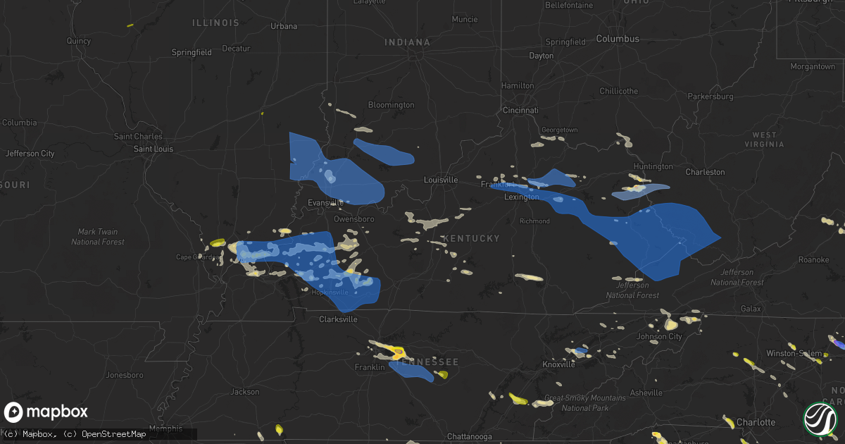
Hail Map in Kentucky on June 17, 2022
Get this storm
June 17 map
$229
one time, instant access
Download today. No call, no setup
Keep the $229
Bought the map and want the full workflow? Apply the entire $229 to a subscription within 7 days. None of it is wasted.
Every map, not just this one
This buys you this map. Subscription and you get every map we run, in the markets you choose from a few cities to whole states to nationwide. Plus real-time alerts the moment a storm fires.
Contact data
Name, contact info, occupancy, even credit band for addresses in the footprint. You go from where it hit to who to call.
Become the source they trust
Unlimited branding weather history reports on demand. You already have the documented answer ready for the property owner, and you are the one who showed up with it.
Property data and RoofTrace estimates
Pull up any address you have got, its value and the exact code rules for that jurisdiction, straight from One Click Code. Then RoofTrace estimates the squares, pitch, and roof value, priced the way you price.
Storm reports in Kentucky
Kentucky
| Date | Description |
|---|---|
| 06/17/20221:22 PM CDT | A tree was blown down in the fleming neon area. |
| 06/17/20221:19 PM CDT | Trees and limbs were reported to have been blown down along us 460. The event time is radar estimated. |
| 06/17/20221:15 PM CDT | Trees were reported to have blown down along us 460 between mm 9 and 10. The event time is radar estimated. |
| 06/17/20221:12 PM CDT | Trees were reported to have been blown down along greasy creek road/ky 3226. |
| 06/17/20221:10 PM CDT | A tree was down on ky 7 near deane. |
| 06/17/20221:10 PM CDT | Trees were reported to have been blown down on ky 122 between mm 5 and 6. The event time is radar estimated. |
| 06/17/20221:10 PM CDT | Several trees and limbs were reported down in the eastern sections of harlan county in the cumberland vicinity. |
| 06/17/20221:08 PM CDT | Trees and limbs were reported to have been blown down in the burnwell community. The time of the event is radar estimated. |
| 06/17/20221:08 PM CDT | Trees were blown in and near hardy along ky 319. The time of the event is radar estimated. |
| 06/17/20221:07 PM CDT | A tree was reported to have been blown down onto ky 582. |
| 06/17/20221:06 PM CDT | Straight line winds blew the metal roof of an auto sale business in belfry. The event time is radar estimated. |
| 06/17/20221:06 PM CDT | Numerous trees and limbs were down between on ky 1460 between the pikeville city limits and the chloe community at the intersection at ky 1460 and us 460. The time of t |
| 06/17/20221:03 PM CDT | Straight line winds leveled an outbuilding to the south of us 119 at a double kwik gas station and a large portion of a billboard on north side of us 119 across from th |
| 06/17/20221:02 PM CDT | Trees were reported to have been blown down in the sidney area. The event time is radar estimated. |
| 06/17/20221:02 PM CDT | Trees and limbs were reported down in the vicinity of evarts. |
| 06/17/20221:00 PM CDT | Trees were reported down near the holly hills shopping center. |
| 06/17/202212:58 PM CDT | Trees were blown down and roofing material blew off a structure in the brookside community. |
| 06/17/202212:57 PM CDT | Dispatch reported a tree down on mcroberts rd. Near grange city... Kentucky. Time established from dispatch call. |
| 06/17/202212:57 PM CDT | Dispatch reported a tree down on watson rd. Near plummers landing... Kentucky. Time established from dispatch call. |
| 06/17/202212:56 PM CDT | Trees and limbs were reported to have been blown down onto ky 468 in the hatfield community. The event time is radar estimated. |
| 06/17/202212:56 PM CDT | Multiple large limbs down |
| 06/17/202212:55 PM CDT | Operators received report of lots of wind damage included damage to signs... Shingles removed... And tree limbs down... With debris in the road in downtown harlan in th |
| 06/17/202212:55 PM CDT | Tree down in south shore. Photo included with report on social media. |
| 06/17/202212:54 PM CDT | A tree was blown down onto ky 1087. The event time is radar estimated. |
| 06/17/202212:52 PM CDT | A tree was blown down onto ky highway 80. |
| 06/17/202212:50 PM CDT | Numerous trees and power lines were blown down along peter cave rd and pigeon roost rd in pilgrim. |
| 06/17/202212:50 PM CDT | 3 trees were reported to have been blown down in the lower johns creek area of pike county. The location and time of the event is estimated from radar. |
| 06/17/202212:48 PM CDT | Numerous trees and power lines were blown down along riverfront rd in lovely. |
| 06/17/202212:48 PM CDT | Numerous trees and power lines were blown down along hode rd in warfield. |
| 06/17/202212:44 PM CDT | Trees and a power line were blown down in helton. |
| 06/17/202212:41 PM CDT | Bell county dispatch reported trees blown down onto old bell high rd. |
| 06/17/202212:41 PM CDT | Trees and limbs were reported to have been blown down via social media in the downtown area of inez. The even time is radar estimated. |
| 06/17/202212:40 PM CDT | Bell county dispatch reported trees blown in kettle island. |
| 06/17/202212:40 PM CDT | Numerous trees and power lines were blown down across all of martin county. As of 630 pm edt... Power was still out across most of the county. The city of inez was part |
| 06/17/202212:40 PM CDT | Trees and power lines were blown down across the city of inez including at the following locations: main street... Route 908 and turkey creek rd... New route 3... Route |
| 06/17/202212:39 PM CDT | Numerous trees and power lines were blown down in tomahawk. |
| 06/17/202212:38 PM CDT | A tree was reported to have been blown down along straight fork. The even time is radar estimated. |
| 06/17/202212:37 PM CDT | A tree was blown down at the intersection of highways 66 and 2011 in beverly. Power outages across the county. |
| 06/17/202212:37 PM CDT | Corrects previous tstm wnd dmg report from 1 wsw prestonsburg. Large tree uprooted and blown over near the corner of scott lane and dingus street. Numerous other trees |
| 06/17/202212:37 PM CDT | Large tree uprooted and blown over near the corner of scott lane and dingus street. Time estimated from radar. |
| 06/17/202212:36 PM CDT | Bell county dimp rotary road in gastonia. |
| 06/17/202212:36 PM CDT | Bell county dispatch reported 3 instances of trees blown onto power lines in the city of pineville. |
| 06/17/202212:34 PM CDT | Several trees and limbs were reported to have been blow down along ky 850 and ky 404 in the david vicinity and elsewhere in the david fire department district. |
| 06/17/202212:34 PM CDT | Large limb down on woodland hills road. Time estimated from radar. |
| 06/17/202212:34 PM CDT | Several trees and limbs were reported to have been blown down in the auxier area. |
| 06/17/202212:34 PM CDT | Numerous trees and powerlines down across the county. |
| 06/17/202212:33 PM CDT | Numerous trees down along abbott creek road... Or kentucky highway 1427. Time estimated from radar. |
| 06/17/202212:33 PM CDT | A tree was blown down onto a home and large tree limbs were blown down. This report was via social media with a picture. |
| 06/17/202212:32 PM CDT | Knox county dispatch reported trees blown down onto power lines in the alex creek area. |
| 06/17/202212:32 PM CDT | Knox county dispatch reported trees blown down onto power lines in the flat lick area. |
| 06/17/202212:32 PM CDT | Trees and powerlines were reported to have been blown down in and near thelma the event time is radar estimated. |
| 06/17/202212:32 PM CDT | Trees and powerlines were reported to have been blown down in and near tutor key. The event time is radar estimated. |
| 06/17/202212:31 PM CDT | Numerous trees and limbs down in the middle creek fire district in the vicinity of dotson and. |
| 06/17/202212:30 PM CDT | A tree was reported to have been blown down. This report is via social media with a picture. The event time is radar estimated. |
| 06/17/202212:30 PM CDT | Corrects previous tstm wnd dmg report from paintsville. Several trees were reported to have been blown down. These report are via social media with pictures. The event |
| 06/17/202212:30 PM CDT | Trees were reported down in the wittensville and nippa communities. The event time is radar estimated. |
| 06/17/202212:30 PM CDT | Trees and limbs were blown down. The event time is radar estimated. |
| 06/17/202212:30 PM CDT | Tree and limbs were reported to have been blown down. The event time is radar estimated. |
| 06/17/202212:29 PM CDT | Utility poles snapped with trees and large limbs down in addition to downed powerlines on adams cemetery road and along ky 114. |
| 06/17/202212:28 PM CDT | Powerlines were blown down. |
| 06/17/202212:25 PM CDT | Large tree limbs were blown down along ky 114. |
| 06/17/202212:24 PM CDT | Trees and limbs were reported to have been blown down. The event time is radar estimated. |
| 06/17/202212:22 PM CDT | A tree was down on powerlines and caught on fire in the redbush and elna vicinity. The local vfd responded. The event time is estimated from radar. |
| 06/17/202212:21 PM CDT | Trees were reported to have been blown down in the falcon community. |
| 06/17/202212:21 PM CDT | Trees were reported to have been blown down near ky 7. The event time is radar estimated. |
| 06/17/202212:20 PM CDT | Trees and limbs were blown down. The event time is radar estimated. |
| 06/17/202212:20 PM CDT | Several trees and powerlines down across the county. |
| 06/17/202212:18 PM CDT | Tree down on highway 30 west of rousseau. Time estimated from radar. |
| 06/17/202212:18 PM CDT | Tree down across highway 30 east of jackson. Time estimated from radar. |
| 06/17/202212:16 PM CDT | Trees were reported to have been blown down in salyersville. The event time is radar estimated. |
| 06/17/202212:16 PM CDT | Large limb down on highway 30 near rousseau. |
| 06/17/202212:14 PM CDT | Large limbs were blown down along ky 172 in eastern morgan county. |
| 06/17/202212:14 PM CDT | Knox county dispatch reported trees blown down onto power lines along siler hill rd. |
| 06/17/202212:13 PM CDT | Trees were reported to have been blown down. The event time is radar estimated. |
| 06/17/202212:12 PM CDT | Trees were reported down in and in the vicinity of west liberty and elsewhere throughout morgan county. |
| 06/17/202212:12 PM CDT | Tree down on highway 30 near the magoffin and breathitt county line. Time estimated from radar. |
| 06/17/202212:12 PM CDT | Tree down on highway 30 near the magoffin and |
| 06/17/202212:11 PM CDT | Trees were reported down in the grape creek area of magoffin county. The event time is radar estimated. |
| 06/17/202212:09 PM CDT | Trees were blown down in the horse creek community. The event time is radar estimated. |
| 06/17/202212:09 PM CDT | Large tree down at corner of ribolt-epworth road and happy hollow road. Time estimated from radar data. |
| 06/17/202212:08 PM CDT | Elliott county dispatch reported trees blown down along ky-486. |
| 06/17/202212:07 PM CDT | A tree was down on the mountain parkway near adele. The event time is radar estimated. |
| 06/17/202212:06 PM CDT | A tree was reported to have been blown down on horse creek road in southern laurel county. The event time is radar estimated. |
| 06/17/202212:05 PM CDT | A tree was reported to have been blown down onto north stewart road. The event time is radar estimated. |
| 06/17/202212:04 PM CDT | Elliott county dispatch reported trees blown down along ky-649. |
| 06/17/202212:04 PM CDT | Elliott county dispatch reported trees blown down along ky-719. |
| 06/17/202212:04 PM CDT | Elliott county dispatch reported trees blown down along ky-32 s. |
| 06/17/202212:04 PM CDT | A tree was reported to have been blown down onto curry road. |
| 06/17/202212:04 PM CDT | Elliott county dispatch reported trees blown down along ky-504. |
| 06/17/202212:01 PM CDT | Elliott county dispatch reported trees blown down along ky-32 n. |
| 06/17/202212:01 PM CDT | Golf ball size hail in fallsburg. |
| 06/17/202212:00 PM CDT | A tree was reported blown down onto ky 312 in southern laurel county. The event time is radar estimated. |
| 06/17/202211:58 AM CDT | Route 8 near maysville closed due to tree damage. |
| 06/17/202211:58 AM CDT | Mccreary county 911 reported many trees down county wide including the community of pine knot. |
| 06/17/202211:57 AM CDT | Corrects time of previous tstm wnd dmg report from wellington. Numerous trees were blown down in and around wellington and throughout the county. A few power outages we |
| 06/17/202211:57 AM CDT | Elliott county dispatch reported trees blown down onto power lines along ky-173 leading to a temporary road closure. |
| 06/17/202211:56 AM CDT | Trees were blown down in ezel including onto 2 mobile homes. |
| 06/17/202211:54 AM CDT | Elliott county dispatch reported trees blown down along devils fork rd. |
| 06/17/202211:51 AM CDT | A large tree limb was down on a residence. |
| 06/17/202211:50 AM CDT | Route 324 closed due to tree damage. |
| 06/17/202211:49 AM CDT | A tree was reported to have been blown down onto london dock road. The event time is radar estimated. |
| 06/17/202211:48 AM CDT | A tree was blown down onto holly fork road in rowan county. This report is via social media with a picture. |
| 06/17/202211:48 AM CDT | A tree was blown down onto holly fork road in rowan county. This report is via |
| 06/17/202211:48 AM CDT | Powerlines were downed due to a snapped powerpole. This report was via social media with a picture. |
| 06/17/202211:47 AM CDT | A tree was blown down onto old flemingsburg road. The event time is radar estimated. |
| 06/17/202211:46 AM CDT | A tree was reported to have been blown down onto adams road. The event time is radar estimated. |
| 06/17/202211:45 AM CDT | Measured at a weather station located at the cave run marinas. |
| 06/17/202211:44 AM CDT | Corrects time from previous tstm wnd dmg report from frenchburg. Numerous trees were blown down in and around frenchburg and through out the county. A few power outages |
| 06/17/202211:44 AM CDT | Numerous trees reported down by dispatch near and around campton. Time estimated by radar. |
| 06/17/202211:44 AM CDT | A tree was blown down onto a mobile home. The event time is radar estimated. |
| 06/17/202211:42 AM CDT | Pulaski county dispatch reported trees blown down onto the ky-192 approximately 18 miles east of somerset. |
| 06/17/202211:41 AM CDT | Powell county 911 call center reported a roof was blown off of an apartment complex in stanton... Kentucky. Time from when call came into dispatch. |
| 06/17/202211:41 AM CDT | A tree was reported to have blown down on a garage. The event time is radar estimated. |
| 06/17/202211:41 AM CDT | A tree reported down near 9000 winchester rd. In clay city... Kentucky. Time estimated from radar. |
| 06/17/202211:41 AM CDT | Tree reported down near 500 hatchers creek rd in stanton... Ky. Time estimated by radar. |
| 06/17/202211:38 AM CDT | A tree was blown down onto a vehicle at the dollar general store in salt lick. |
| 06/17/202211:35 AM CDT | Pulaski county 911 reported trees blown down along hall ridge rd. |
| 06/17/202211:35 AM CDT | Pulaski county dispatch reported trees blown down along slate branch road. |
| 06/17/202211:35 AM CDT | Hay barn blown over... No injuries. |
| 06/17/202211:33 AM CDT | Pulaski county dispatch reported trees blown down along hickory nut rd. |
| 06/17/202211:31 AM CDT | Wayne county 911 reported 2 large trees blown down on ky-1275 n in the 600 block. Time estimated from radar. |
| 06/17/202211:31 AM CDT | Wayne county 911 call center reported a large tree blown down across ky-167 in the 700 block. |
| 06/17/202211:31 AM CDT | Tree reported down on beech fork road near clay city... Ky. Time estimated from radar. |
| 06/17/202211:30 AM CDT | Tree down across the kroger bypass. |
| 06/17/202211:30 AM CDT | Large tree limbs down at spring meadows drive and town branch road. |
| 06/17/202211:30 AM CDT | Dispatch reported a tree down on tar ridge rd. Near rogers... Kentucky. Time established from radar. |
| 06/17/202211:27 AM CDT | Trees and power lines down on powersville-harrison county road. Time estimated from radar. |
| 06/17/202211:26 AM CDT | Corrects previous tstm wnd dmg report from 1 sw plummers landing. Dispatch reported a tree down on watson rd. Near plummers landing... Kentucky. Time established from d |
| 06/17/202211:26 AM CDT | Corrects previous tstm wnd dmg report from 1 sw grange city. Dispatch reported a tree down on mcroberts rd. Near grange city... Kentucky. Time established from dispatch |
| 06/17/202211:25 AM CDT | Wayne county 911 call center reported large tree blown down onto ky-858 in the 1000 block. |
| 06/17/202211:24 AM CDT | Pulaski county dispatch reported trees blown down along bourbon rd. |
| 06/17/202211:23 AM CDT | Wayne county dispatch reported a large tree blown down onto utility lines along old susie rd. |
| 06/17/202211:20 AM CDT | Trees down over roadways across various parts of the county. |
| 06/17/202211:17 AM CDT | Roughly 20 trees reported down due to wind around the county. 3 transformer fires and numerous power outages were also reported. Time estimated from radar. |
| 06/17/202211:15 AM CDT | Several trees down in various parts of the county... Including the city of paris. |
| 06/17/202211:15 AM CDT | Several trees down in various parts of the county... Including the city of paris. |
| 06/17/202211:14 AM CDT | Tree down. |
| 06/17/202211:05 AM CDT | Roof damage to the smiser building in cynthiana. Multiple trees reported down in harrison county as well with a few causing road closures. Time estimated from radar. |
| 06/17/202210:58 AM CDT | Tree down on roadway. |
| 06/17/202210:57 AM CDT | Trees down on gentry mill rd. |
| 06/17/202210:57 AM CDT | Numerous trees were blown down in and around wellington and throughout the county. A few power outages were ongoing at 830 pm edt. |
| 06/17/202210:55 AM CDT | Trees down. |
| 06/17/202210:50 AM CDT | Trees down. |
| 06/17/202210:44 AM CDT | Numerous trees were blown down in and around frenchburg and through out the county. A few power outages were ongoing at 830 pm edt. |
| 06/17/202210:43 AM CDT | Delayed report. Measured 61 mph gust recorded at scott county eoc. |
| 06/17/202210:40 AM CDT | Trees down on hippe-agee rd. |
| 06/17/202210:40 AM CDT | Trees down on grassy springs rd. Between us-60 and ky-1659. |
| 06/17/202210:40 AM CDT | Corrects previous tstm wnd dmg report from 2 wnw georgetown. Tree down on golf course. |
| 06/17/202210:40 AM CDT | Trees... Power lines... And telephones reported down. |
| 06/17/202210:37 AM CDT | Corrects previous tstm wnd dmg report from 3 nnw stamping ground. Trees down across roadway. |
| 06/17/202210:35 AM CDT | Trees down. |
| 06/17/202210:35 AM CDT | Tree down on mobile home. |
| 06/17/202210:35 AM CDT | Trees down on east side of franklin county. |
| 06/17/202210:30 AM CDT | Trees down on us-62. |
| 06/17/202210:27 AM CDT | Large tree limbs down. |
| 06/17/202210:25 AM CDT | Tree down. |
| 06/17/202210:20 AM CDT | Damage to barn roof. |
| 06/17/202210:20 AM CDT | Tree down on golf course. |
| 06/17/202210:16 AM CDT | Tree and power lines on propane tank. |
| 06/17/202210:09 AM CDT | Trees and power lines reported down across simpson county. |
| 06/17/202210:04 AM CDT | Powerlines down 800 block of black jack rd. |
| 06/17/20229:50 AM CDT | Trees reported down. |
| 06/17/20229:30 AM CDT | Trees reported down. |
| 06/17/20229:30 AM CDT | Trees reported down. |
| 06/17/20229:30 AM CDT | Trees reported down. |
| 06/17/20229:26 AM CDT | Trees down across roadway. |
| 06/17/20229:00 AM CDT | Several trees down east of murray. |
| 06/17/20229:00 AM CDT | Tree down across ky-79. |
| 06/17/20229:00 AM CDT | Public report via mping - 1 inch tree limbs broken... Shingles blown off. |
| 06/17/20228:55 AM CDT | Awos station kcey murray ky. |
| 06/17/20228:47 AM CDT | Public mping report- trees uprooted or snapped. |
| 06/17/20228:39 AM CDT | Public report via mping. |
| 06/17/20228:30 AM CDT | Trees down on jack thomason rd just northwest of eddyville. |
| 06/17/20228:30 AM CDT | A metal roof of a softball shed was removed... And sheet metal was thrown downwind. Time estimated from radar. Public report relayed by broadcast media. |
| 06/17/20228:21 AM CDT | Public report via mping - 1 inch limbs broken. |
| 06/17/20228:12 AM CDT | Was still gusting 55 to 60 mph at time of report. |
| 06/17/20228:10 AM CDT | Estimated 55 to 60 mph winds. |
| 06/17/20228:05 AM CDT | Lots of large limbs down and power lines down throughout town. |
| 06/17/20227:53 AM CDT | At 1253 PM EDT, severe thunderstorms were located along a line extending from near Head of Grassy to Big Woods, moving southeast at 35 mph. HAZARD...60 mph wind gusts and penny size hail. SOURCE...Radar indicated. IMPACT...Expect damage to roofs, siding, and trees. Severe thunderstorms will be near... Zag around 100 PM EDT. |
| 06/17/20227:49 AM CDT | At 1249 PM EDT, a severe thunderstorm was located over Yatesville Lake State Park, moving east at 40 mph. HAZARD...60 mph wind gusts and penny size hail. SOURCE...Radar indicated. IMPACT...Expect damage to roofs, siding, and trees. Locations impacted include... Louisa, Wayne, Yatesville Lake State Park, Fort Gay, Ranger, Gill, East Lynn Lake, Kiahsville, Dunlow, Harts, Branchland, Fallsburg, East Lynn, Genoa, Myra and Glenhayes. |
| 06/17/20227:47 AM CDT | Public reported m59 mph wind gust - personal weather station. |
| 06/17/20227:46 AM CDT | Public report via mping - 1 inch tree limbs broken... Shingles blown off. |
| 06/17/20227:44 AM CDT | At 1244 PM EDT, a severe thunderstorm was located over Cornwell, or near Frenchburg, moving east at 40 mph. HAZARD...70 mph wind gusts and penny size hail. SOURCE...Radar indicated. IMPACT...Expect considerable tree damage. Damage is likely to mobile homes, roofs, and outbuildings. This severe thunderstorm will be near... Frenchburg around 1250 PM EDT. Mariba around 1255 PM EDT. Wellington around 100 PM EDT.Other locations in the path of this severe thunderstorm include Ezel,Murphyfork and Henry. |
| 06/17/20227:39 AM CDT | At 1239 PM EDT, a severe thunderstorm was located over High Falls, or near Campton, moving east at 35 mph. HAZARD...60 mph wind gusts and penny size hail. SOURCE...Radar indicated. IMPACT...Expect damage to roofs, siding, and trees. This severe thunderstorm will be near... Vortex around 1245 PM EDT. Baptist around 1250 PM EDT. Lexie around 1255 PM EDT.Other locations in the path of this severe thunderstorm include UpperGilmore, Belknap and Burg. |
| 06/17/20227:26 AM CDT | At 1226 PM EDT, a severe thunderstorm was located over Ringos Mills, or 11 miles southeast of Flemingsburg, moving east at 35 mph. HAZARD...60 mph wind gusts and penny size hail. SOURCE...Radar indicated. IMPACT...Expect damage to roofs, siding, and trees. This severe thunderstorm will be near... Plummers Landing around 1230 PM EDT. Sharkey around 1235 PM EDT. Hilda around 1240 PM EDT. Hays Crossing around 1245 PM EDT.Other locations in the path of this severe thunderstorm includeMorehead and Haldeman. |
| 06/17/20227:16 AM CDT | At 1215 PM EDT, severe thunderstorms were located along a line extending from 11 miles west of Fairview to near Sideview to near Winchester, moving east at 40 mph. HAZARD...60 mph wind gusts and penny size hail. SOURCE...Radar indicated. IMPACT...Expect damage to roofs, siding, and trees. Severe thunderstorms will be near... Sharpsburg around 1225 PM EDT. Flat Creek around 1230 PM EDT. Fairview around 1235 PM EDT.Other locations in the path of these severe thunderstorms includeOwingsville, Stanton and Flemingsburg. |
| 06/17/20227:10 AM CDT | At 1210 PM EDT, a severe thunderstorm was located near Klondike, or 8 miles southwest of Mount Sterling, moving east at 40 mph. HAZARD...60 mph wind gusts and penny size hail. SOURCE...Radar indicated. IMPACT...Expect damage to roofs, siding, and trees. This severe thunderstorm will be near... Klondike around 1215 PM EDT. Prewitt around 1220 PM EDT. Camargo around 1225 PM EDT. Jeffersonville around 1230 PM EDT.Other locations in the path of this severe thunderstorm include LuckyStop and Cedar Groves. |
| 06/17/20226:59 AM CDT | At 1159 AM EDT, severe thunderstorms were located along a line extending from 7 miles east of Owenton to 6 miles northwest of Georgetown to near Lawrenceburg, moving east at 50 mph. HAZARD...60 mph wind gusts and penny size hail. SOURCE...Radar indicated. IMPACT...Expect damage to roofs, siding, and trees. Locations impacted include... Veterans Park, Fayette Mall, U K Arboretum, Chevy Chase, Northland, Paris, Cynthiana, Cadentown, Winchester and Carlisle. |
| 06/17/20226:43 AM CDT | At 1143 AM EDT/1043 AM CDT/, a severe thunderstorm was located over Columbia, moving east at 40 mph. HAZARD...60 mph wind gusts and penny size hail. SOURCE...Radar indicated. IMPACT...Expect damage to roofs, siding, and trees. Locations impacted include... Jamestown. |
| 06/17/20226:37 AM CDT | At 1137 AM EDT, severe thunderstorms were located along a line extending from 13 miles northwest of Georgetown to 7 miles east of Frankfort to near Lawrenceburg, moving east at 40 mph. HAZARD...60 mph wind gusts and penny size hail. SOURCE...Radar indicated. IMPACT...Expect damage to roofs, siding, and trees. Severe thunderstorms will be near... Lexington and Georgetown around 1155 AM EDT.Other locations in the path of these severe thunderstorms includeHighlands, Nicholasville, Dunbar High School, Bryan Station,Thoroughbred Acres, Fayette Mall, U K Arboretum, Cardinal Hill,Meadowthorpe, Paris, Cynthiana, Veterans Park, Chevy Chase, Cadentownand Northland. |
| 06/17/20226:29 AM CDT | At 1127 AM EDT, a severe thunderstorm was located 14 miles northeast of Springfield, moving east at 35 mph. HAZARD...60 mph wind gusts and penny size hail. SOURCE...Radar indicated. IMPACT...Expect damage to roofs, siding, and trees. This severe thunderstorm will be near... Harrodsburg around 1145 AM EDT. |
| 06/17/20226:22 AM CDT | At 1121 AM EDT/1021 AM CDT/, a severe thunderstorm was located near Greensburg, and is moving eat at 35 mph. HAZARD...60 mph wind gusts and quarter size hail. SOURCE...Radar indicated. IMPACT...Hail damage to vehicles is expected. Expect wind damage to roofs, siding, and trees. Locations impacted include... Greensburg. |
| 06/17/20226:12 AM CDT | At 1112 AM EDT, a severe thunderstorm was located 7 miles northeast of Shelbyville, moving east at 40 mph. HAZARD...60 mph wind gusts and penny size hail. SOURCE...Radar indicated. IMPACT...Expect damage to roofs, siding, and trees. Locations impacted include... Frankfort. |
| 06/17/20226:08 AM CDT | At 1107 AM EDT, a severe thunderstorm was located 11 miles south of Versailles, moving east at 40 mph. HAZARD...60 mph wind gusts. SOURCE...Radar indicated. IMPACT...Expect damage to trees and power lines. Locations impacted include... Rising Sun, Warsaw, Florence, Pleasant, Glencoe, Fairview, Patriot, Center Square, Aberdeen, Interstate 71 at US Route 127, Waterloo, Steele Bottom, Markland, Avonburg, Moorefield, Farmers Retreat, Friendship, Rabbit Hash, Quercus Grove and Mount Sterling.This includes I-71 in Kentucky between mile markers 62 and 63. |
| 06/17/20225:02 AM CDT | At 1001 AM CDT, severe thunderstorms were located along a line extending from Portland to Nashville, moving east at 50 mph. HAZARD...60 mph wind gusts. SOURCE...Radar indicated. IMPACT...Expect damage to roofs, siding, and trees. Locations impacted include... Gallatin, Lebanon, Lafayette, Hartsville, Madison, Hendersonville, La Vergne, Mount Juliet, Goodlettsville, White House, Millersville, Lakewood, Westmoreland, Ridgetop, Cross Plains, Portland, Hermitage, Rural Hill, Belinda City and Old Hickory.This includes the following highways... Interstate 40 between mile markers 218 and 232. Interstate 65 between mile markers 92 and 112. |
| 06/17/20224:35 AM CDT | At 935 AM CDT, severe thunderstorms were located along a line extending from 10 miles west of Coopertown to 11 miles southeast of Clarksville to near Tennessee Ridge, moving southeast at 55 mph. HAZARD...60 mph wind gusts. SOURCE...Radar indicated. IMPACT...Expect damage to roofs, siding, and trees. Locations impacted include... Clarksville, Springfield, Dickson, Ashland City, Erin, Goodlettsville, White House, Millersville, Greenbrier, Coopertown, White Bluff, Kingston Springs, Pegram, Ridgetop, McEwen, Cross Plains, Burns, Tennessee Ridge, Joelton and Pleasant View. |
| 06/17/20224:34 AM CDT | At 934 AM EDT, a severe thunderstorm was located 8 miles west of Elizabethtown, moving east at 20 mph. HAZARD...Quarter size hail. SOURCE...Radar indicated. IMPACT...Damage to vehicles is expected. Locations impacted include... Elizabethtown. |
| 06/17/20224:20 AM CDT | At 920 AM CDT, a severe thunderstorm was located near Dunmor, moving southeast at 40 mph. HAZARD...60 mph wind gusts. SOURCE...Radar indicated. IMPACT...Expect damage to roofs, siding, and trees. This severe thunderstorm will remain over mainly rural areas of Logan and southwestern Butler Counties, including the following locations... Insco, Gordonsville, Dimple, Spa, Epleys, Leetown, Dennis, Wolf Lick, Crossroad and Buffalo Fork. |
| 06/17/20224:03 AM CDT | At 902 AM CDT, severe thunderstorms were located along a line extending from near Dunmor to 12 miles east of Murray, moving southeast at 45 mph. HAZARD...60 mph wind gusts and penny size hail. SOURCE...Radar indicated. IMPACT...Expect damage to roofs, siding, and trees. Locations impacted include... Clarksville, Dover, Guthrie, Big Rock, Adams, Cedar Hill, Cumberland City, Land Between The Lakes, Indian Mound, Palmyra and Woodlawn.This includes Interstate 24 between mile markers 1 and 16. |
| 06/17/20223:54 AM CDT | At 853 AM CDT, severe thunderstorms were located along a line extending from 9 miles north of Dunmor to near Hopkinsville to near Land Between The Lakes Area, moving southeast at 30 mph. HAZARD...60 mph wind gusts. SOURCE...Radar indicated. This is an extension to the previous warning. IMPACT...Expect damage to roofs, siding, and trees. Severe thunderstorms will be near... Hopkinsville and Dunmor around 910 AM CDT.This includes the following highways... Interstate 24 in Kentucky between Mile Markers 66 and 75. Western Kentucky Parkway between Mile Markers 54 and 65. Pennyrile Parkway between Mile Markers 7 and 20. |
| 06/17/20223:20 AM CDT | At 820 AM CDT, severe thunderstorms were located along a line extending from near Beech Grove to near Olney to near Eddyville, moving southeast at 40 mph. HAZARD...60 mph wind gusts. SOURCE...Radar indicated. IMPACT...Expect damage to roofs, siding, and trees. Severe thunderstorms will be near... Princeton around 840 AM CDT.Other locations in the path of these severe thunderstorms includeCrofton and Cobb.This includes the following highways... Interstate 24 in Kentucky between Mile Markers 42 and 75. Interstate 69 in Kentucky between Mile Markers 68 and 90. Pennyrile Parkway between Mile Markers 7 and 26. |
| 06/17/20223:14 AM CDT | At 813 AM CDT, severe thunderstorms were located along a line extending from Santa Claus to near St. Joseph, moving east at 45 mph. HAZARD...60 mph wind gusts. SOURCE...Radar indicated. IMPACT...Expect damage to roofs, siding, and trees. These severe thunderstorms will remain over mainly rural areas of southern Perry, Hancock, western Breckinridge and northeastern Ohio Counties, including the following locations... Frymire, Skillman, Goering, Ralph, Gerald, Tar Fork, Rome, Vanzant, Ellmitch and Arrington Corner. |
| 06/17/20223:06 AM CDT | At 806 AM CDT, severe thunderstorms were located along a line extending from near Hartford to near Central City to Madisonville, moving southeast at 20 mph. HAZARD...60 mph wind gusts. SOURCE...Radar indicated. IMPACT...Expect damage to roofs, siding, and trees. Locations impacted include... Central City, Powderly, Greenville, Nortonville, Graham and Dunmor.This includes the following highways... Interstate 69 in Kentucky between Mile Markers 101 and 110. Western Kentucky Parkway between Mile Markers 39 and 65. Pennyrile Parkway between Mile Markers 29 and 34. |
| 06/17/20222:32 AM CDT | At 731 AM CDT, severe thunderstorms were located along a line extending from Equality to 8 miles north of Dixon Springs to near Karnak, moving southeast at 50 mph. HAZARD...60 mph wind gusts and penny size hail. SOURCE...Radar indicated. IMPACT...Expect damage to roofs, siding, and trees. Severe thunderstorms will be near... Ridgway and Equality around 735 AM CDT. Shawneetown around 740 AM CDT. Golconda and New Columbia around 750 AM CDT.Other locations in the path of these severe thunderstorms includeMetropolis, Rosiclare and Brookport.This includes Interstate 24 in Illinois between Mile Markers 12 and38. |
| 06/17/20222:26 AM CDT | At 726 AM CDT, severe thunderstorms were located along a line extending from near St. Francisville to Owensville to 6 miles south of New Harmony, moving east at 50 mph. HAZARD...60 mph wind gusts and penny size hail. SOURCE...Radar indicated. IMPACT...Expect damage to roofs, siding, and trees. Locations impacted include... Lynnville, Petersburg, Newburgh, Chandler, Folsomville and Boonville.This includes the following highways... Interstate 69 in Indiana between Mile Markers 6 and 7, near MileMarker 22, and between Mile Markers 38 and 52. Interstate 64 in Indiana between Mile Markers 30 and 54. |
| 06/16/20229:06 PM CDT | At 205 PM EDT, a severe thunderstorm was located over Diane, or 16 miles northeast of Harlan, moving east at 30 mph. HAZARD...60 mph wind gusts and penny size hail. SOURCE...Radar indicated. IMPACT...Expect damage to roofs, siding, and trees. This severe thunderstorm will remain over mainly rural areas of northwestern Harlan, southeastern Leslie, southwestern Letcher and southeastern Perry Counties. |
| 06/16/20229:03 PM CDT | At 203 PM EDT, a severe thunderstorm was located over Gordon, or 14 miles southwest of Whitesburg, moving east at 45 mph. HAZARD...60 mph wind gusts and penny size hail. SOURCE...Radar indicated. IMPACT...Expect damage to roofs, siding, and trees. Locations impacted include... Cumberland, Evarts, Lynch, Benham, Flint, Totz, Black Bottom, Dizney, Louellen, Clover Fork, Lewis Creek and Defeated Creek. |
| 06/16/20228:48 PM CDT | At 148 PM EDT, a severe thunderstorm was located near South Webster, moving southeast at 35 mph. HAZARD...60 mph wind gusts and penny size hail. SOURCE...Radar indicated. IMPACT...Expect damage to trees and power lines. Locations impacted include... Wheelersburg, South Webster, Lyra and Powellsville. |
| 06/16/20228:41 PM CDT | At 141 PM EDT, a severe thunderstorm was located over Asher, or 9 miles south of Hyden, moving east at 30 mph. HAZARD...60 mph wind gusts and penny size hail. SOURCE...Radar indicated. IMPACT...Expect damage to roofs, siding, and trees. This severe thunderstorm will be near... Mozelle around 145 PM EDT. Chappell around 150 PM EDT. Napier around 200 PM EDT.Other locations in the path of this severe thunderstorm include BigLaurel, Pine Mountain and Totz. |
| 06/16/20228:35 PM CDT | At 134 PM EDT, a severe thunderstorm was located over Ulysses, or 8 miles northeast of Paintsville, moving east at 35 mph. HAZARD...60 mph wind gusts. SOURCE...Radar indicated. IMPACT...Expect damage to roofs, siding, and trees. Locations impacted include... Ulysses, Charley and Crum. |
| 06/16/20228:28 PM CDT | At 128 PM EDT, a severe thunderstorm was located near Yatesville Lake State Park, moving east at 35 mph. HAZARD...60 mph wind gusts. SOURCE...Radar indicated. IMPACT...Expect damage to roofs, siding, and trees. Locations impacted include... Louisa, Yatesville Lake State Park, Fort Gay, Dunlow, East Lynn Lake, Gallup, Fallsburg, East Lynn, Genoa, Clifford and Glenhayes. |
| 06/16/20228:16 PM CDT | At 116 PM EDT, a severe thunderstorm was located over Webbville, or near Grayson Lake State Park, moving east at 50 mph. HAZARD...60 mph wind gusts. SOURCE...Radar indicated. IMPACT...Expect damage to roofs, siding, and trees. Locations impacted include... Denton, Webbville, Houckville, Willard and Hitchins. |
| 06/16/20228:11 PM CDT | At 111 PM EDT, severe thunderstorms were located along a line extending from Teges to Park Valley, moving east at 50 mph. HAZARD...60 mph wind gusts and penny size hail. SOURCE...Radar indicated. IMPACT...Expect damage to roofs, siding, and trees. Locations impacted include... Manchester, Hyden, Hoskinston, Grace, Shoal, Brightshade, Lake, Treadway, Goose Rock, Barcreek, Bush and Chestnutburg. |
| 06/16/20228:08 PM CDT | At 108 PM EDT, severe thunderstorms were located along a line extending from Steele to Portsmouth, moving southeast at 25 mph. HAZARD...60 mph wind gusts and penny size hail. SOURCE...Radar indicated. IMPACT...Expect damage to roofs, siding, and trees. Severe thunderstorms will be near... Press around 115 PM EDT. Moon around 125 PM EDT.Other locations in the path of these severe thunderstorms includeMima, Buck, Win and Elmrock. |
| 06/16/20228:03 PM CDT | At 103 PM EDT, a severe thunderstorm was located over Mashfork, or near Salyersville, moving east at 30 mph. HAZARD...60 mph wind gusts and penny size hail. SOURCE...Radar indicated. IMPACT...Expect damage to roofs, siding, and trees. This severe thunderstorm will be near... Ballot around 110 PM EDT. Swamp Branch around 115 PM EDT. Leander around 120 PM EDT.Other locations in the path of this severe thunderstorm include EastPoint and Prestonsburg. |
All States Impacted by Hail Map on June 17, 2022
Cities Impacted by Hail Map on June 17, 2022
- Eureka, MT
- Georgetown, KY
- Kalispell, MT
- Condon, MT
- Spencer, WV
- East Setauket, NY
- Island Falls, ME
- Smyrna Mills, ME
- Oakfield, ME
- Newcastle, WY
- Sweet Grass, MT
- Cut Bank, MT
- Hill City, SD
- Blue Creek, OH
- Stout, OH
- Elkview, WV
- Charleston, WV
- Kenna, WV
- Deadwood, SD
- Lead, SD
- Advent, WV
- Ripley, WV
- Walton, WV
- Gandeeville, WV
- Dandridge, TN
- Jefferson City, TN
- Evansville, IN
- Newburgh, IN
- Bardstown, KY
- Cadiz, KY
- Frankfort, KY
- Valier, MT
- Browning, MT
- Heart Butte, MT
- Liberty, WV
- Red House, WV
- Leon, WV
- Buffalo, WV
- Poca, WV
- Port Jefferson, NY
- Port Jefferson Station, NY
- Mount Sinai, NY
- Mount Zion, WV
- Vine Grove, KY
- Custer, KY
- Irvington, KY
- Cecilia, KY
- Guston, KY
- Rineyville, KY
- Mechanicsville, VA
- Hanover, VA
- Ashland, VA
- Hartfield, VA
- Davin, WV
- Acton, ME
- Lebanon, ME
- Hillsboro, KY
- Morehead, KY
- Foster, KY
- Augusta, KY
- Brooksville, KY
- Mount Lookout, WV
- Southside, WV
- Henderson, WV
- Lavalette, WV
- Owensboro, KY
- Utica, KY
- Nashville, NC
- Blackwater, VA
- Kyles Ford, TN
- Powellton, WV
- Kimberly, WV
- Wayne, WV
- Prichard, WV
- Louisa, KY
- Catlettsburg, KY
- Rush, KY
- Boonville, IN
- Skippers, VA
- Emporia, VA
- Luttrell, TN
- Powder Springs, TN
- Newsoms, VA
- Courtland, VA
- Whaleyville, MD
- Frankford, DE
- Berlin, MD
- Willards, MD
- Delmar, MD
- Showell, MD
- Delmar, DE
- Millsboro, DE
- Laurel, DE
- Bishopville, MD
- Ocean City, MD
- Parsonsburg, MD
- Pittsville, MD
- Fayetteville, TN
- Guin, AL
- Hamilton, AL
- Brilliant, AL
- Suwanee, GA
- Buford, GA
- Lancaster, SC
- Bennettsville, SC
- Wallace, SC
- McColl, SC
- Hamlet, NC
- East Point, KY
- Cerulean, KY
- Gracey, KY
- Hopkinsville, KY
- Diagonal, IA
- Lenox, IA
- Clearfield, IA
- Madisonville, KY
- Dawson Springs, KY
- Nebo, KY
- Hermitage, TN
- Watertown, TN
- Murfreesboro, TN
- Madison, TN
- La Vergne, TN
- Nashville, TN
- Brentwood, TN
- Lebanon, TN
- Smyrna, TN
- Old Hickory, TN
- Whites Creek, TN
- Antioch, TN
- Mount Juliet, TN
- Linton, IN
- Switz City, IN
- Lyons, IN
- New Durham, NH
- Vesuvius, VA
- Buena Vista, VA
- Lexington, VA
- Fairfield, VA
- Natural Bridge, VA
- Hurricane, WV
- Winfield, WV
- Lexington, KY
- Paris, KY
- Sadieville, KY
- Corinth, KY
- Julian, WV
- Foster, WV
- Ridgeview, WV
- Sheridan, WY
- Saluda, VA
- Locust Hill, VA
- Salt Lick, KY
- Patoka, IN
- Hazleton, IN
- Rogersville, TN
- Marion, KY
- Fredonia, KY
- Hurley, VA
- Fort Gay, WV
- Webbville, KY
- Hacker Valley, WV
- Centertown, KY
- Central City, KY
- Yale, VA
- White Plains, KY
- Elkton, KY
- Drakesboro, KY
- Greenville, KY
- Lewisburg, KY
- Sharon Grove, KY
- Crofton, KY
- Dunmor, KY
- Nortonville, KY
- Beech Creek, KY
- Belton, KY
- Russellville, KY
- Flemingsburg, KY
- Raphine, VA
- Pinewood, SC
- Summerton, SC
- Georgetown, DE
- Reed, KY
- Alkol, WV
- Monroe, VA
- Glasgow, VA
- Easton, ME
- Presque Isle, ME
- Shelbyville, KY
- Tomahawk, KY
- Natural Bridge Station, VA
- Wallingford, KY
- Evans, WV
- Given, WV
- Cottageville, WV
- Shelburn, IN
- Sullivan, IN
- Greensburg, KY
- Summersville, KY
- Hillsborough, NC
- Grand Chain, IL
- Sandy Hook, KY
- Elkfork, KY
- Blountville, TN
- Vest, KY
- Jackson, KY
- Hueysville, KY
- Spartanburg, SC
- Pauline, SC
- Lizemores, WV
- Sturgis, KY
- Cave In Rock, IL
- Shawneetown, IL
- Junction, IL
- Elizabethtown, IL
- Patriot, OH
- Gallipolis, OH
- Jarratt, VA
- Drewryville, VA
- Boykins, VA
- Capron, VA
- Providence, KY
- Salem, KY
- Clay, KY
- Livermore, KY
- Slaughters, KY
- Rumsey, KY
- Bremen, KY
- Dixon, KY
- Hanson, KY
- Island, KY
- Calhoun, KY
- Manitou, KY
- Sacramento, KY
- Battleboro, NC
- Castalia, NC
- Strawberry Plains, TN
- Tremont, MS
- Fulton, MS
- Golden, MS
- Vina, AL
- Red Bay, AL
- Scotland Neck, NC
- Halifax, NC
- Enfield, NC
- Salem, IN
- Sneedville, TN
- Thorn Hill, TN
- Sunburst, MT
- Newberry, SC
- Johnson City, TN
- Henderson, NC
- Essex, MT
- Portsmouth, OH
- Wheelersburg, OH
- Franklin Furnace, OH
- Ripley, OH
- South Charleston, WV
- Ireland, WV
- Harts, WV
- Princeton, KY
- Detroit, AL
- Madisonville, TN
- Norwich, CT
- Bozrah, CT
- Minford, OH
- Milton, NH
- Union, NH
- Equality, IL
- Gallipolis Ferry, WV
- Dover, KY
- South Portsmouth, KY
- South Shore, KY
- Falmouth, KY
- Princeton, IN
- Columbia Falls, MT
- Louisa, VA
- Cape May, NJ
- Wildwood, NJ
- Lynx, OH
- Chapmanville, WV
- Big Creek, WV
- Albion, IL
- West Salem, IL
- Dugger, IN
- Midway, KY
- Stamping Ground, KY
- Crane, IN
- Odon, IN
- Loogootee, IN
- Elnora, IN
- Stem, NC
- Olmsted, IL
- Ullin, IL
- Pulaski, IL
- Villa Ridge, IL
- Dongola, IL
- Delbarton, WV
- Sarah Ann, WV
- Gilbert, WV
- Omar, WV
- Helvetia, WV
- Pickens, WV
- Buffalo, KY
- Sonora, KY
- Magnolia, KY
- Upton, KY
- Hodgenville, KY
- Mount Sherman, KY
- Knoxville, TN
- Whitesville, KY
- Hartford, KY
- Ranger, WV
- Branchland, WV
- Mosheim, TN
- Waynesburg, KY
- Eubank, KY
- Amherstdale, WV
- Man, WV
- Summersville, WV
- Dixie, WV
- Victor, WV
- Drennen, WV
- Belva, WV
- Swiss, WV
- Ansted, WV
- Coxs Creek, KY
- Bloomfield, KY
- Clearmont, WY
- Buffalo, WY
- Decker, MT
- Birney, MT
- Stony Creek, VA
- Rocky Mount, NC
- Chapel Hill, NC
- Liberty Hill, SC
- Patrick, SC
- Society Hill, SC
- Cheraw, SC
- Morven, NC
- Chesterfield, SC
- Garland, NC
- Rural Hall, NC
- Pfafftown, NC
- Winston Salem, NC
- Newport, TN
- Bybee, TN
- Parrottsville, TN
- Creal Springs, IL
- New Burnside, IL
- Stonefort, IL
- Lawrenceville, GA
- Grayson, GA
- Loganville, GA
- Leighton, AL
- Wilson, NC
- Elm City, NC
- Midway, TN
- Beaverton, AL
- Clio, SC
- Metter, GA
- Twin City, GA
- Cobbtown, GA
- Cape Girardeau, MO
- McClure, IL
- Franklinton, NC
- Statesboro, GA
- Kodak, TN
- Vance, AL
- Union, SC
- Brent, AL
- Marion, AL
- Norway, SC
- Hartsville, SC
- Ledbetter, KY
- Kuttawa, KY
- Grand Rivers, KY
- Smithland, KY
- Bessemer City, NC
- Clover, SC
- Gastonia, NC
- Kings Mountain, NC
- Kingston, GA
- Brooklet, GA
- Fort Branch, IN
- Francisco, IN
- Round O, SC
- Cottageville, SC
- Ruffin, SC
- Walterboro, SC
- Sylacauga, AL
- Monticello, GA
- Parkton, NC
- Lumber Bridge, NC
- Saint Pauls, NC
- Raeford, NC
- Madison, GA
- Eatonton, GA
- Crisfield, MD
- Hallwood, VA
- Yemassee, SC
- Red Springs, NC
- Maxton, NC
- Evensville, TN
- Decatur, TN
- Oxford, MS
- Cameron, SC
- Saint Matthews, SC
- Harrison, GA
- Davisboro, GA
- Sandersville, GA
- Bartow, GA
- Columbiana, AL
- Chelsea, AL
- Helena, AL
- Pelham, AL
- Shaw, MS
- Boyle, MS
- Arp, TX
- Tyler, TX
- Eustace, TX
- Canton, TX
- Brunswick, GA
- Hortense, GA
- Waynesville, GA
- Talladega, AL
- Mitchell, GA
- Rock Island, TN
- Whatley, AL
- Grove Hill, AL
- Savannah, TN
- Gibson, GA
- Stryker, MT
- Cross, SC
- Holly Hill, SC
- Tellico Plains, TN
- Singer, LA
- Bonaire, GA
- Orangeburg, SC
- Santee, SC
- Elloree, SC
- Islandton, SC
- Moravian Falls, NC
- Wilkesboro, NC
- Orange, VA
- Vonore, TN
- Anna, IL
- Jonesboro, IL
- Havelock, NC
- Union Grove, NC
- Statesville, NC
- Paducah, KY
- West Paducah, KY
- Heath Springs, SC
- Atlanta, GA
- Peachtree Corners, GA
- Norcross, GA
- Moore, SC
- Dequincy, LA
- Niota, TN
- Athens, TN
- Sparta, GA
- Varnville, SC
- Hampton, SC
- Grady, AL
- Ramer, AL
- Pomaria, SC
- Whitmire, SC
- Brunson, SC
- Early Branch, SC
- Sulligent, AL
- Deatsville, AL
- Hackleburg, AL
- Andrews, SC
- McKenney, VA
- Morganfield, KY
- Meherrin, VA
- Victoria, VA
- Green Bay, VA
- Darlington, SC
- Nettleton, MS
- Rockingham, NC
- Ellerbe, NC
- Fort Mill, SC
- Waxhaw, NC
- Winnsboro, SC
- Great Falls, SC
- Peachland, NC
- Pembroke, NC
- Lumberton, NC
- Kershaw, SC
- Engelhard, NC
- Taylors, SC
- Greer, SC
- Randolph, AL
- Jemison, AL
- Dry Branch, GA
- Kathleen, GA
- Travelers Rest, SC
- Roswell, GA
- Marietta, GA
- Rockwell, NC
- Salisbury, NC
- Gold Hill, NC
- Lexington, NC
- Clemmons, NC
- Counce, TN
- Mantachie, MS
- Saltillo, MS
- Guntown, MS
- Ridge, MD
- Dameron, MD
- Scotland, MD
- Piney Point, MD
- Saint Inigoes, MD
- Temperanceville, VA
- Parksley, VA
- Mears, VA
- Bloxom, VA
- Sanford, VA
- Greenbush, VA
- Ellijay, GA
- Magnolia, NC
- Rose Hill, NC
- Crandall, GA
- Vanceboro, NC
- New Market, TN
- Cartersville, GA
- Blenheim, SC
- Berry, AL
- Columbus, MS
- Soperton, GA
- Sweetwater, TN
- Englewood, TN
- Walnut, MS
- Weogufka, AL
- Jacksonville, TX
- North Charleston, SC
- Charleston, SC
- Thomson, GA
- Blackville, SC
- Barnwell, SC
- Williston, SC
- Neeses, SC
- Frankston, TX
- Glenwood, GA
- Leland, MS
- Tuscaloosa, AL
- Sylvania, GA
- Waynesboro, GA
- Sardis, GA
- Blythe, GA
- Keysville, GA
- Hephzibah, GA
- Girard, GA
- Byron, GA
- Montezuma, GA
- Wrightsville, GA
- Selma, AL
- Sumter, SC
- Vernon, AL
- Dingess, WV
- Linden, AL
- Pennington, AL
- Sweet Water, AL
- Georgetown, SC
- Brierfield, AL
- Montevallo, AL
- Marbury, AL
- Elmore, AL
- Prattville, AL
- Pembroke, GA
- Fort Stewart, GA
- Ruther Glen, VA
- Doswell, VA
- Beaverdam, VA
- Natchez, MS
- Thomasville, AL
- Pine Hill, AL
- Rock Hill, SC
- Duncanville, AL
- Cottondale, AL
- Hazlehurst, GA
- Jackson, SC
- Tennille, GA
- Pinehurst, GA
- Byromville, GA
- Vienna, GA
- Covington, GA
- Mansfield, GA
- Buncombe, IL
- Bluff City, TN
- Elizabethton, TN
- Dalzell, SC
- Dublin, GA
- Quinton, AL
- Mulga, AL
- West Point, MS
- Hoffman, NC
- Marston, NC
- Birmingham, AL
- Troup, TX
- Ridgeville, SC
- Lane, SC
- Athens, TX
- Mount Sterling, KY
- Gattman, MS
- Caledonia, MS
- Patterson, GA
- Nahunta, GA
- Wolf Lake, IL
- Partridge, KY
- Wise, VA
- Eolia, KY
- Appalachia, VA
- Norton, VA
- Philpot, KY
- Estillfork, AL
- Scottsboro, AL
- Gatesville, NC
- Gates, NC
- Eure, NC
- Pollocksville, NC
- Pegram, TN
- Saint Charles, KY
- Dayton, TN
- Spring Hope, NC
- Powell, TN
- Arapahoe, NC
- Grantsboro, NC
- New Bern, NC
- Metropolis, IL
- Rosiclare, IL
- Cypress, IL
- Grantsburg, IL
- Simpson, IL
- Hampton, KY
- Vienna, IL
- Karnak, IL
- Belknap, IL
- Brookport, IL
- Golconda, IL
- Goreville, IL
- Jonesborough, TN
- Clarkson, KY
- Rydal, GA
- White, GA
- Advance, NC
- Enoree, SC
- Clinton, NC
- Alamo, GA
- McRae Helena, GA
- Greensboro, NC
- Whitsett, NC
- Winfield, AL
- Maryville, TN
- Walland, TN
- Burlington, NC
- Browns Summit, NC
- Reidsville, NC
- Gibsonville, NC
- Elon, NC
- Goose Creek, SC
- Lithonia, GA
- Carbon Hill, AL
- Nauvoo, AL
- Eldridge, AL
- Townley, AL
- Abbeville, GA
- Maysville, NC
- Toney, AL
- Harvest, AL
- Acworth, GA
- Dallas, GA
- Aiken, SC
- Kingstree, SC
- Kellyton, AL
- Goodwater, AL
- Mount Pleasant, SC
- Milledgeville, GA
- Windsor, SC
- Clyo, GA
- Olar, SC
- Fairfax, SC
- Ulmer, SC
- Warthen, GA
- Luverne, AL
- Stamps, AR
- Duncan, MS
- Reynolds, GA
- Nacogdoches, TX
- Darien, GA
- Townsend, GA
- Quitman, GA
- Bokeelia, FL
- Shady Valley, TN
- Mountain City, TN
- Avera, GA
- Stapleton, GA
- Louisville, GA
- Blaine, TN
- Mascot, TN
- Ramer, TN
- Somerset, KY
- Jackson, MO
- Burfordville, MO
- Hopkins, SC
- Wedgefield, SC
- Columbia, KY
- Bristol, TN
- High Point, NC
- Jamestown, NC
- Colfax, NC
- Kernersville, NC
- Hiddenite, NC
- Harmony, NC
- Cleveland, NC
- Olin, NC
- Laurel Bloomery, TN
- Cedar Grove, NC
- Mebane, NC
- Roxboro, NC
- Prospect Hill, NC
- Timberlake, NC
- Hurdle Mills, NC
- Delphia, KY
- Linefork, KY
- Whitesburg, KY
- Cumberland, KY
- Hallie, KY
- Clayton, GA
- Walhalla, SC
- Mountain Rest, SC
- Westminster, SC
- Seneca, SC
- Monroe, NC
- Wingate, NC
- Marshville, NC
- Cumming, GA
- Woodstock, AL
- Merryville, LA
- Bishopville, SC
- Camden, SC
- Rembert, SC
- Glendale, KY
- Boston, KY
- New Haven, KY
- Elizabethtown, KY
- Beulaville, NC
- Pink Hill, NC
- Kenansville, NC
- Richlands, NC
- Clifton Forge, VA
- Eagle Rock, VA
- Edmonton, KY
- Bonnieville, KY
- Cobbs Creek, VA
- Morristown, TN
- White Pine, TN
- Oak Ridge, MO
- Seabrook, SC
- Beaufort, SC
- Coosawhatchie, SC
- Sheldon, SC
- Ridgeland, SC
- Crandall, TX
- Greenville, SC
- Landrum, SC
- Conway, SC
- Buffalo, SC
- Jonesville, SC
- Lyons, GA
- Cobden, IL
- Eastview, KY
- Montgomery, AL
- Marshallville, GA
- Fort Valley, GA
- Tar Heel, NC
- Bladenboro, NC
- Cochran, GA
- Warner Robins, GA
- Perry, GA
- Hawkinsville, GA
- Denmark, SC
- Cordele, GA
- Lambert, MS
- Lugoff, SC
- Columbia, SC
- Eastover, SC
- Elgin, SC
- Gadsden, SC
- Blair, SC
- Pinetops, NC
- Fountain, NC
- Macclesfield, NC
- Lumber City, GA
- Talking Rock, GA
- Spencer, NC
- Bumpass, VA
- Partlow, VA
- Spotsylvania, VA
- Tiplersville, MS
- West Blocton, AL
- White Oak, NC
- Swainsboro, GA
- East Dublin, GA
- Duncan, SC
- Woodruff, SC
- Roebuck, SC
- Lowndesboro, AL
- Kingsport, TN
- Ruby, SC
- Jeffersonville, KY
- Richland, IN
- Elberfeld, IN
- Oakland City, IN
- Waterloo, OH
- Bristol, VA
- Garysburg, NC
- Jackson, NC
- Roanoke Rapids, NC
- Weldon, NC
- Middleton, TN
- Catawba, SC
- Lilburn, GA
- Prosperity, SC
- North, SC
- Seagoville, TX
- Starkville, MS
- Estill, SC
- White Oak, GA
- Waverly, GA
- London, KY
- Salyersville, KY
- East Glacier Park, MT
- Lansing, NC
- Campbellsville, KY
- Graham, KY
- Keavy, KY
- Ferguson, KY
- Rutledge, TN
- Talbott, TN
- Unionville, VA
- Aylett, VA
- Mineral, VA
- Manquin, VA
- Inez, KY
- Mcminnville, TN
- Smithville, TN
- Kermit, WV
- Lenore, WV
- Breeden, WV
- Holden, WV
- Logan, WV
- Chapin, SC
- Little Mountain, SC
- Todd, NC
- Zionville, NC
- Creston, NC
- Apex, NC
- Durham, NC
- Cary, NC
- Creedmoor, NC
- Oxford, NC
- Damascus, VA
- Clinton, SC
- Fairmont, NC
- Liberty, TN
- Greenwood Springs, MS
- Amory, MS
- Hamilton, MS
- Mount Croghan, SC
- Rougemont, NC
- Mount Vernon, GA
- Corinth, MS
- Guys, TN
- Blackstock, SC
- Carlisle, SC
- Benoit, MS
- Pageland, SC
- Mantee, MS
- Rochelle, GA
- Tarboro, NC
- Swanquarter, NC
- Newington, GA
- Crane Hill, AL
- Bremen, AL
- Pineland, SC
- Garfield, GA
- Barnardsville, NC
- Latta, SC
- Springfield, GA
- Eutawville, SC
- Moncks Corner, SC
- Bonneau, SC
- Rockledge, GA
- Lewisville, AR
- Collins, GA
- Dermott, AR
- Toomsboro, GA
- Valdosta, GA
- Hahira, GA
- Big Clifty, KY
- Leitchfield, KY
- Earlington, KY
- Corryton, TN
- Tamms, IL
- Monticello, KY
- Iuka, MS
- Woodleaf, NC
- Cooleemee, NC
- Jasper, TX
- Westfield, ME
- Polebridge, MT
- Iron Gate, VA
- West Columbia, SC
- Blythewood, SC
- Jenkinsville, SC
- Irmo, SC
- Shaw Afb, SC
- Walling, TN
- Shiloh, TN
- Alpharetta, GA
- Town Creek, AL
- Tuscumbia, AL
- Bessemer, AL
- Garner, NC
- Fuquay Varina, NC
- Butner, NC
- Morrisville, NC
- Youngsville, NC
- Bahama, NC
- Raleigh, NC
- Wake Forest, NC
- Leopold, IN
- Bone Gap, IL
- Chrisney, IN
- Stendal, IN
- Mount Carmel, IL
- Grayville, IL
- Evanston, IN
- Winslow, IN
- Browns, IL
- Spurgeon, IN
- Saint Anthony, IN
- Jasper, IN
- Lawrenceville, IL
- Ferdinand, IN
- Griffin, IN
- Velpen, IN
- Vincennes, IN
- Lynnville, IN
- Saint Meinrad, IN
- Saint Croix, IN
- Tell City, IN
- Troy, IN
- Petersburg, IN
- Bridgeport, IL
- Chandler, IN
- Birdseye, IN
- Haubstadt, IN
- Hawesville, KY
- Santa Claus, IN
- Bristow, IN
- Decker, IN
- Cynthiana, IN
- Holland, IN
- Poseyville, IN
- Saint Francisville, IL
- Branchville, IN
- Grandview, IN
- Dale, IN
- Lincoln City, IN
- Claremont, IL
- Dundas, IL
- Gentryville, IN
- Allendale, IL
- Parkersburg, IL
- Huntingburg, IN
- Bellmont, IL
- Calhoun, IL
- Sumner, IL
- Owensville, IN
- Otwell, IN
- Lamar, IN
- Tennyson, IN
- Lewisport, KY
- Olney, IL
- Rockport, IN
- Hardinsburg, IN
- Cannelburg, IN
- English, IN
- Washington, IN
- Orleans, IN
- Campbellsburg, IN
- French Lick, IN
- West Baden Springs, IN
- Montgomery, IN
- Milltown, IN
- Dubois, IN
- Paoli, IN
- Shoals, IN
- Marengo, IN
- Fredericksburg, IN
- Eddyville, IL
- Guthrie, KY
- Trenton, KY
- Eddyville, KY
- Sebree, KY
- Mortons Gap, KY
- Allensville, KY
- Burna, KY
- Morgantown, KY
- Adams, TN
- Clarksville, TN
- Oak Grove, KY
- Olmstead, KY
- Pembroke, KY
- Adairville, KY
- Auburn, KY
- Henlawson, WV
- Olympia, KY
- War, WV
- Verner, WV
- Banner, KY
- Grethel, KY
- South Williamson, KY
- Willis, VA
- Whitewood, VA
- Weeksbury, KY
- Eggleston, VA
- Bluefield, VA
- Leburn, KY
- Debord, KY
- Elkhorn City, KY
- Freeman, WV
- Iaeger, WV
- Versailles, KY
- Austinville, VA
- Parrott, VA
- Baisden, WV
- Harold, KY
- Belspring, VA
- Stollings, WV
- Staffordsville, KY
- Check, VA
- Pippa Passes, KY
- Lick Creek, KY
- Raven, VA
- Mousie, KY
- Brenton, WV
- Kyle, WV
- Staffordsville, VA
- Gunlock, KY
- Stanton, KY
- Rock, WV
- Hindman, KY
- Denniston, KY
- West Van Lear, KY
- Vansant, VA
- Deane, KY
- Canada, KY
- Hellier, KY
- Teaberry, KY
- Yolyn, WV
- Pembroke, VA
- Raven, KY
- Mallie, KY
- Betsy Layne, KY
- Auxier, KY
- Richlands, VA
- Floyd, VA
- Jesse, WV
- Langley, KY
- David, KY
- McAndrews, KY
- Newport, VA
- Winchester, KY
- Raysal, WV
- Varney, KY
- Lovely, KY
- Wheelwright, KY
- Wayland, KY
- Simon, WV
- Ashcamp, KY
- Forest Hills, KY
- Topmost, KY
- Phelps, KY
- Bramwell, WV
- Clear Fork, WV
- Royalton, KY
- Paynesville, WV
- Davy, WV
- Mize, KY
- McDowell, KY
- Bevinsville, KY
- Williamson, WV
- Maybeury, WV
- Draper, VA
- Breaks, VA
- Bypro, KY
- Elkhorn, WV
- Camp Creek, WV
- Nora, VA
- Neon, KY
- Fanrock, WV
- Hazel Green, KY
- Shelby Gap, KY
- Beaver, KY
- Dana, KY
- Jolo, WV
- Stopover, KY
- Cannel City, KY
- Belfry, KY
- Means, KY
- Rowe, VA
- Oceana, WV
- Switzer, WV
- Barren Springs, VA
- Steele, KY
- Robinson Creek, KY
- Wilsondale, WV
- Clinchco, VA
- Ransom, KY
- Haysi, VA
- Martin, KY
- Princeton, WV
- Regina, KY
- Grundy, VA
- Raccoon, KY
- Tram, KY
- Indian Valley, VA
- Jewell Ridge, VA
- Kegley, WV
- Pinsonfork, KY
- Copper Hill, VA
- Dema, KY
- Hagerhill, KY
- Fedscreek, KY
- Hardy, KY
- Beeson, WV
- Ivel, KY
- Chauncey, WV
- Pikeville, KY
- Pound, VA
- Ripplemead, VA
- Lackey, KY
- Mouthcard, KY
- Matheny, WV
- Eastern, KY
- Max Meadows, VA
- Salem, VA
- Elliston, VA
- Spanishburg, WV
- Dugspur, VA
- Swords Creek, VA
- Kimper, KY
- Clayhole, KY
- Glen Lyn, VA
- Crum, WV
- Herndon, WV
- Blacksburg, VA
- Minnie, KY
- Owingsville, KY
- Huddy, KY
- Oakwood, VA
- Hope, KY
- Switchback, WV
- Oil Springs, KY
- Glen Fork, WV
- Phyllis, KY
- Wellington, KY
- Ezel, KY
- Vancleve, KY
- Matewan, WV
- Kite, KY
- Riner, VA
- Big Rock, VA
- Wytheville, VA
- Melvin, KY
- Berwind, WV
- Lake, WV
- Bays, KY
- Davenport, VA
- Panther, WV
- Pocahontas, VA
- Tazewell, VA
- Radford, VA
- Narrows, VA
- McCarr, KY
- New Richmond, WV
- Jackhorn, KY
- Saulsville, WV
- Hiwassee, VA
- Bland, VA
- Pilot, VA
- Garrett, KY
- North Spring, WV
- Pilgrim, KY
- Shelbiana, KY
- Dunlow, WV
- Dwale, KY
- Bent Mountain, VA
- Stanville, KY
- Fancy Gap, VA
- Squire, WV
- Beauty, KY
- Pineville, WV
- North Tazewell, VA
- Shawsville, VA
- Peterstown, WV
- Elbert, WV
- Garner, KY
- Rousseau, KY
- Pilgrims Knob, VA
- Pecks Mill, WV
- Drift, KY
- Campton, KY
- Lyburn, WV
- Bandy, VA
- McRoberts, KY
- Virgie, KY
- Belcher, KY
- Stone, KY
- Honaker, VA
- Cleveland, VA
- Ikes Fork, WV
- Thelma, KY
- Clay City, KY
- Kimball, WV
- Frenchburg, KY
- Birchleaf, VA
- Montcalm, WV
- McClure, VA
- Mallory, WV
- West Liberty, KY
- Meally, KY
- Boons Camp, KY
- Rich Creek, VA
- Bastian, VA
- Mohawk, WV
- Ceres, VA
- Pine Top, KY
- Northfork, WV
- Sidney, KY
- Hillsville, VA
- Bim, WV
- Pearisburg, VA
- Athens, WV
- Dublin, VA
- Slade, KY
- Paintsville, KY
- Welch, WV
- Coeburn, VA
- Dante, VA
- Pulaski, VA
- Van Lear, KY
- Prestonsburg, KY
- Coal Mountain, WV
- Clintwood, VA
- Wharncliffe, WV
- Printer, KY
- Bee, VA
- Bluefield, WV
- Warfield, KY
- Williamsport, KY
- Allen, KY
- Lashmeet, WV
- Hanover, WV
- Anawalt, WV
- Woodlawn, VA
- Freeburn, KY
- Millstone, KY
- Cyclone, WV
- Christiansburg, VA
- Rocky Gap, VA
- Hi Hat, KY
- Majestic, KY
- Blue River, KY
- Jenkins, KY
- Matoaka, WV
- Falls Mills, VA
- Wyoming, WV
- Sharpsburg, KY
- Ewing, KY
- Carlisle, KY
- Moorefield, KY
- Blaine, KY
- Genoa, WV
- Lowmansville, KY
- East Lynn, WV
- Adams, KY
- Martha, KY
- Isonville, KY
- Readyville, TN
- Auburntown, TN
- Milton, TN
- Lascassas, TN
- Woodbury, TN
- Fairfield, AL
- Parrish, AL
- Cordova, AL
- Oakman, AL
- Jasper, AL
- Dolomite, AL
- Pleasant Grove, AL
- Adamsville, AL


