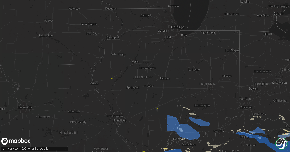
Hail Map in Illinois on June 17, 2022
Get this storm
June 17 map
$229
one time, instant access
Download today. No call, no setup
Keep the $229
Bought the map and want the full workflow? Apply the entire $229 to a subscription within 7 days. None of it is wasted.
Every map, not just this one
This buys you this map. Subscription and you get every map we run, in the markets you choose from a few cities to whole states to nationwide. Plus real-time alerts the moment a storm fires.
Contact data
Name, contact info, occupancy, even credit band for addresses in the footprint. You go from where it hit to who to call.
Become the source they trust
Unlimited branding weather history reports on demand. You already have the documented answer ready for the property owner, and you are the one who showed up with it.
Property data and RoofTrace estimates
Pull up any address you have got, its value and the exact code rules for that jurisdiction, straight from One Click Code. Then RoofTrace estimates the squares, pitch, and roof value, priced the way you price.
Storm reports in Illinois
Illinois
| Date | Description |
|---|---|
| 06/17/20228:18 AM CDT | Dime to quarter size hail at brockport bridge. |
| 06/17/20228:05 AM CDT | Public report via mping - 3 inch tree limbs broken. |
| 06/17/20227:55 AM CDT | Tree down across road on us 45 at mt mission rd. |
| 06/17/20227:50 AM CDT | Tree limbs and power lines down. Time estimated. |
| 06/17/20227:43 AM CDT | Public report via mping - 1 inch tree limbs broken... Shingles blown off. |
| 06/17/20227:35 AM CDT | Numerous trees are down. |
| 06/17/20227:22 AM CDT | Mainly small branches blown down near walmart in lawrenceville on haven road. |
| 06/17/20227:20 AM CDT | Few trees covering roadways as well as numerous branches and debris. |
| 06/17/20227:18 AM CDT | 1 inch tree limbs broken... Shingles blown off home. |
| 06/17/20227:16 AM CDT | Awos station kcul carmi il. |
| 06/17/20227:15 AM CDT | Several power lines and at least one tree on a house. Numerous limbs down. Downed power line blocking il rt 1 and 15. |
| 06/17/20227:15 AM CDT | Hollow oak tree blew down on power lines causing power outage. |
| 06/17/20227:13 AM CDT | A few trees down. |
| 06/17/20227:12 AM CDT | A local report indicates 1.00 inch wind near 1 WNW ANNA |
| 06/17/20227:10 AM CDT | Tree and shed damage. Window air unit blown out. |
| 06/17/20227:10 AM CDT | 5 trees down. |
| 06/17/20227:00 AM CDT | Lots of tree damage. Tree fell on home. |
| 06/17/20227:00 AM CDT | Trees down on power lines. Large limbs down. Pool blown apart and lawn mower flipped over by wind. |
| 06/17/20227:00 AM CDT | From facebook. Power lines and large branches down. Time estimated from radar. |
| 06/17/20223:42 AM CDT | At 842 AM EDT, severe thunderstorms were located along a line extending from 7 miles east of Russellville to 9 miles west of Petersburg, moving east at 45 mph. This line recently produced estimated 60 mph winds in Decker. HAZARD...60 mph wind gusts. SOURCE...Radar indicated. IMPACT...Expect damage to roofs, siding, and trees. Severe thunderstorms will be near... Bicknell around 850 AM EDT. Edwardsport around 855 AM EDT. Plainville around 900 AM EDT.Other locations in the path of these severe thunderstorms includeMontgomery, Glendale Fishery, Cannelburg, Loogootee and West BoggsLake. |
| 06/17/20223:10 AM CDT | At 809 AM EDT, severe thunderstorms were located along a line extending from near Sumner to near Lancaster to near Grayville, moving east at 55 mph. HAZARD...60 mph wind gusts and quarter size hail. SOURCE...Radar indicated. IMPACT...Hail damage to vehicles is expected. Expect wind damage to roofs, siding, and trees. Severe thunderstorms will be near... Vincennes University around 825 AM EDT.Other locations in the path of these severe thunderstorms includeVincennes, Decker, Bruceville, Bicknell, Monroe City, Wheatland andEdwardsport. |
| 06/17/20222:52 AM CDT | At 751 AM CDT, severe thunderstorms were located along a line extending from Chandler to near Corydon to 8 miles northwest of Marion, moving southeast at 40 mph. HAZARD...60 mph wind gusts. SOURCE...Radar indicated. IMPACT...Expect damage to roofs, siding, and trees. Severe thunderstorms will be near... Robards around 805 AM CDT. Sebree around 810 AM CDT.Other locations in the path of these severe thunderstorms includeEureka, Beech Grove, Rockport, Calhoun, Grandview and Olney.This includes the following highways... Interstate 165 between Mile Markers 60 and 70. Interstate 69 in Kentucky between Mile Markers 91 and 101, andbetween Mile Markers 110 and 148. Interstate 69 in Indiana between Mile Markers 1 and 4. Interstate 64 in Indiana between Mile Markers 57 and 59. Audubon Parkway between Mile Markers 1 and 23. |
| 06/17/20222:09 AM CDT | At 709 AM CDT, severe thunderstorms were located along a line extending from near Lancaster to near Enfield, moving east at 45 mph. HAZARD...70 mph wind gusts and quarter size hail. SOURCE...Radar indicated. IMPACT...Hail damage to vehicles is expected. Expect considerable tree damage. Wind damage is also likely to mobile homes, roofs, and outbuildings. Locations impacted include... New Harmony, Mount Vernon, Blairsville, Darmstadt, Kasson, Evansville and Melody Hill.This includes the following highways... Interstate 69 in Indiana near Mile Marker 5, between Mile Markers 8and 21, and between Mile Markers 23 and 37. Interstate 64 in Indiana between Mile Markers 5 and 29. |
| 06/17/20222:04 AM CDT | At 703 AM CDT, severe thunderstorms were located along a line extending from near Mcleansboro to near Cambria, moving southeast at 35 mph. HAZARD...60 mph wind gusts and nickel size hail. SOURCE...Radar indicated. IMPACT...Expect damage to roofs, siding, and trees. Severe thunderstorms will be near... Herrin, Carterville, Crainville, Cambria and Energy around 710 AM CDT. Marion around 715 AM CDT.Other locations in the path of these severe thunderstorms includeCreal Springs and Lake Of Egypt Area.This includes the following highways... Interstate 24 in Illinois near Mile Marker 1. Interstate 57 in Illinois between Mile Markers 44 and 61. |
| 06/17/20221:53 AM CDT | At 653 AM CDT, severe thunderstorms were located along a line extending from near Parkersburg to 8 miles northeast of Mcleansboro, moving east at 40 mph. HAZARD...70 mph wind gusts and quarter size hail. SOURCE...Radar indicated. IMPACT...Hail damage to vehicles is expected. Expect considerable tree damage. Wind damage is also likely to mobile homes, roofs, and outbuildings. These severe thunderstorms will remain over mainly rural areas of Wayne County, including the following locations... Jeffersonville, Mount Erie, Johnsonville, Sims, Keenes and Golden Gate.This includes Interstate 64 in Illinois between Mile Markers 92 and115. |
| 06/17/20221:47 AM CDT | At 647 AM CDT, severe thunderstorms were located along a line extending from near Olney to near Mcleansboro, moving southeast at 55 mph. HAZARD...70 mph wind gusts and quarter size hail. SOURCE...Radar indicated. IMPACT...Hail damage to vehicles is expected. Expect considerable tree damage. Wind damage is also likely to mobile homes, roofs, and outbuildings. Severe thunderstorms will be near... Lancaster, Norris City and West Salem around 705 AM CDT.Other locations in the path of these severe thunderstorms includeMount Carmel.This includes the following highways... Interstate 64 in Indiana between Mile Markers 1 and 2. Interstate 64 in Illinois between Mile Markers 116 and 130. |
| 06/17/20221:44 AM CDT | At 644 AM CDT, severe thunderstorms were located along a line extending from near Bluford to near Du Quoin, moving southeast at 30 mph. HAZARD...60 mph wind gusts and nickel size hail. SOURCE...Radar indicated. IMPACT...Expect damage to roofs, siding, and trees. Severe thunderstorms will be near... Valier around 700 AM CDT.Other locations in the path of these severe thunderstorms includeChristopher, Zeigler, Royalton, West Frankfort and Mcleansboro.This includes the following highways... Interstate 57 in Illinois between Mile Markers 62 and 103. Interstate 64 in Illinois between Mile Markers 65 and 91. |
| 06/17/20221:17 AM CDT | At 617 AM CDT, severe thunderstorms were located along a line extending from near Bible Grove to 10 miles south of Salem, moving southeast at 45 mph. HAZARD...70 mph wind gusts and quarter size hail. SOURCE...Radar indicated. IMPACT...Hail damage to vehicles is expected. Expect considerable tree damage. Wind damage is also likely to mobile homes, roofs, and outbuildings. These severe thunderstorms will remain over mainly rural areas of Wayne County, including the following locations... Jeffersonville, Mount Erie, Johnsonville, Sims, Keenes and Golden Gate.This includes Interstate 64 in Illinois between Mile Markers 92 and115. |
| 06/17/20221:17 AM CDT | At 616 AM CDT, severe thunderstorms were located along a line extending from near Bible Grove to near Helm, moving east at 55 mph. HAZARD...60 mph wind gusts. SOURCE...Radar indicated. IMPACT...Expect damage to roofs, siding, and trees. Severe thunderstorms will be near... Bible Grove and Ingraham around 620 AM CDT. Dundas around 635 AM CDT. |
| 06/17/20221:10 AM CDT | At 609 AM CDT, severe thunderstorms were located along a line extending from near Salem to near Irvington, moving southeast at 45 mph. HAZARD...70 mph wind gusts and quarter size hail. SOURCE...Radar indicated. IMPACT...Hail damage to vehicles is expected. Expect considerable tree damage. Wind damage is also likely to mobile homes, roofs, and outbuildings. Severe thunderstorms will be near... Woodlawn around 620 AM CDT. Mount Vernon around 625 AM CDT.Other locations in the path of these severe thunderstorms includeBluford.This includes the following highways... Interstate 57 in Illinois between Mile Markers 88 and 105. Interstate 64 in Illinois between Mile Markers 63 and 91. |
| 06/17/202212:47 AM CDT | At 547 AM CDT, severe thunderstorms were located along a line extending from near Shumway to Ingraham, moving east at 25 mph. HAZARD...60 mph wind gusts and quarter size hail. SOURCE...Radar indicated. IMPACT...Hail damage to vehicles is expected. Expect wind damage to roofs, siding, and trees. Severe thunderstorms will be near... Bogota around 555 AM CDT. Teutopolis around 605 AM CDT.Other locations in the path of these severe thunderstorms includeWest Liberty, Ste. Marie, Montrose, Toledo, Greenup, Jewett andHidalgo.This includes the following highways... Interstate 57 between mile markers 143 and 173. Interstate 70 between mile markers 85 and 122. |
| 06/17/202212:45 AM CDT | At 545 AM CDT, severe thunderstorms were located along a line extending from 6 miles northeast of New Athens to 8 miles southwest of New Design to near Old Mines, moving southeast at 30 mph. HAZARD...60 mph wind gusts and penny size hail. SOURCE...Radar indicated. IMPACT...Expect damage to roofs, siding, and trees. Severe thunderstorms will be near... Marissa around 555 AM CDT. Tilden around 605 AM CDT.Other locations in the path of these severe thunderstorms includeSparta, Ste. Genevieve, Coulterville, Evansville, Bonne Terre,Leadwood, Desloge, Chester, St. Mary, Farmington and Park Hills.This includes Interstate 55 in Missouri between exits 141 and 162. This also includes St. Joe State Park, St. Francois State Park, HawnState Park, Felix Valle House State Park, and Missouri Mines HistoricSite. |
| 06/17/202212:43 AM CDT | At 542 AM CDT, severe thunderstorms were located along a line extending from Moweaqua to near Brownstown, moving east at 25 mph. HAZARD...60 mph wind gusts. SOURCE...Radar indicated. IMPACT...Expect damage to roofs, siding, and trees. Locations impacted include... Altamont, Bethany and Findlay.This includes Interstate 70 between mile markers 79 and 84. |
| 06/17/202212:32 AM CDT | At 532 AM CDT, severe thunderstorms were located along a line extending from near Coffeen to Aviston, moving east at 35 mph. HAZARD...70 mph wind gusts and nickel size hail. SOURCE...Trained weather spotters. IMPACT...Expect considerable tree damage. Damage is likely to mobile homes, roofs, and outbuildings. Severe thunderstorms will be near... Carlyle and Beckemeyer around 550 AM CDT.Other locations in the path of these severe thunderstorms includeRamsey, Vandalia, Brownstown, Shattuc, Centralia, Sandoval, Wamac,Central City, Fairman, Wrights Corner, St. Elmo, Odin and Salem.This includes the following highways... Interstate 70 in Illinois between exits 61 and 76. Interstate 57 in Illinois between exits 109 and 135. Interstate 64 in Illinois between exits 34 and 61.This also includes Ramsey Lake State Park and Carlyle LakeRecreational Area. |
| 06/17/202212:23 AM CDT | At 523 AM CDT, severe thunderstorms were located along a line extending from near Antonia to near Miramiguoa Park, moving east at 60 mph. HAZARD...60 mph wind gusts and penny size hail. SOURCE...Radar indicated. IMPACT...Expect damage to roofs, siding, and trees. Severe thunderstorms will be near... Festus, Crystal City, Herculaneum and Horine around 530 AM CDT. Old Mines around 540 AM CDT.Other locations in the path of these severe thunderstorms include DeSoto, Red Bud, Olympian Village, Evansville and Baldwin.This includes Interstate 55 in Missouri between exits 154 and 178. This also includes Washington State Park and St. Francois State Park. |
| 06/17/202212:22 AM CDT | At 521 AM CDT, severe thunderstorms were located along a line extending from near Shumway to near Dieterich, moving east at 25 mph. HAZARD...60 mph wind gusts and quarter size hail. SOURCE...Radar indicated. IMPACT...Hail damage to vehicles is expected. Expect wind damage to roofs, siding, and trees. Severe thunderstorms will be near... Dieterich around 530 AM CDT. Wheeler around 535 AM CDT. Teutopolis and Bogota around 540 AM CDT.Other locations in the path of these severe thunderstorms includeNewton and Montrose.This includes the following highways... Interstate 57 between mile markers 144 and 173. Interstate 70 between mile markers 83 and 110. |
| 06/17/202212:14 AM CDT | At 514 AM CDT, a severe thunderstorm was located near Farmersville, or 8 miles east of Virden, moving east at 25 mph. HAZARD...60 mph wind gusts. SOURCE...Radar indicated. IMPACT...Expect damage to roofs, siding, and trees. Locations impacted include... Morrisonville and Jeisyville.This includes Interstate 55 between mile markers 78 and 80. |
| 06/17/202212:10 AM CDT | At 510 AM CDT, severe thunderstorms were located along a line extending from near Virden to near Bunker Hill, moving east at 35 mph. HAZARD...60 mph wind gusts and nickel size hail. SOURCE...Radar indicated. IMPACT...Expect damage to roofs, siding, and trees. Severe thunderstorms will be near... Farmersville around 530 AM CDT.Other locations in the path of these severe thunderstorms includeWhite Oak, Sorento, Taylor Springs, Reno, Hillsboro, Coffeen andSchram City.This includes the following highways... Interstate 70 in Illinois between exits 36 and 52. Interstate 55 in Illinois between exits 52 and 63.This also includes Lake Lou Yaeger. |
| 06/16/202211:58 PM CDT | At 458 AM CDT, severe thunderstorms were located along a line extending from near Jacksonville to 6 miles southwest of Franklin, moving east at 40 mph. HAZARD...60 mph wind gusts. SOURCE...Radar indicated. IMPACT...Expect damage to roofs, siding, and trees. Severe thunderstorms will be near... Franklin around 505 AM CDT. Alexander and Waverly around 510 AM CDT.This includes Interstate 72 between mile markers 65 and 79. |
| 06/16/202211:42 PM CDT | At 442 AM CDT, severe thunderstorms were located along a line extending from New Berlin to near Jeisyville, moving east at 30 mph. HAZARD...60 mph wind gusts and nickel size hail. SOURCE...Radar indicated. IMPACT...Expect damage to roofs, siding, and trees. Severe thunderstorms will be near... Taylorville, Kincaid, Edinburg, Bulpitt and Jeisyville around 445 AM CDT. Auburn and Stonington around 500 AM CDT.Other locations in the path of these severe thunderstorms includeChatham, Springfield, Rochester and Pawnee.This includes the following highways... Interstate 55 between mile markers 77 and 99. Interstate 72 between mile markers 80 and 110. |
| 06/16/202211:09 PM CDT | At 408 AM CDT, a severe thunderstorm was located near Griggsville, or 13 miles north of Pittsfield, moving southeast at 40 mph. HAZARD...60 mph wind gusts and nickel size hail. SOURCE...Radar indicated. IMPACT...Expect damage to roofs, siding, and trees. This severe thunderstorm will be near... Meredosia and Naples around 420 AM CDT. Bluffs around 425 AM CDT. Exeter around 430 AM CDT. Winchester and Chapin around 435 AM CDT. Woodson and Manchester around 450 AM CDT. Murrayville around 455 AM CDT. Franklin around 500 AM CDT.Other locations impacted by this severe thunderstorm includePrentice, Sinclair, Riggston, Merritt, Concord, Glasgow, Oxville,Nortonville, Lynnville and South Jacksonville.This includes Interstate 72 between mile markers 43 and 79. |
| 06/16/202210:59 PM CDT | At 358 AM CDT, severe thunderstorms were located along a line extending from near Eolia to 6 miles northeast of Bellflower to near Williamsburg, moving east at 80 mph. HAZARD...60 mph wind gusts and penny size hail. SOURCE...Radar indicated. IMPACT...Expect damage to roofs, siding, and trees. Severe thunderstorms will be near... Hawk Point and Eolia around 405 AM CDT. Elsberry, Davis and New Florence around 410 AM CDT. Troy, Hermann, Moscow Mills, Jonesburg and Fountain N' Lakes around 415 AM CDT.Other locations in the path of these severe thunderstorms include St.Paul, Winfield, Hardin, Chain of Rocks, Warrenton, New Haven,Truesdale, Treloar, St. Charles, Washington, Jerseyville,Marthasville, Innsbrook, Dutzow, Maryland Heights, Bridgeton, Elsah,New Melle, Portage Des Sioux, Augusta, Orchard Farms, Hazelwood,Brighton, West Alton and Defiance.This includes Interstate 70 in Missouri between exits 155 and 229. This also includes Deutschheim Historic Site, Cuivre River StatePark, Clarks Hill/Norton Historic Site, Graham Cave State Park, FirstMissouri State Capitol Historic Site, and Pere Marquette State Park. |
| 06/16/202210:53 PM CDT | At 353 AM CDT, a severe thunderstorm was located near Ashland, or 13 miles southeast of Virginia, moving east at 30 mph. Additional strong to severe storms were northwest of Virginia and also moving east. HAZARD...60 mph wind gusts and quarter size hail. SOURCE...Radar indicated. IMPACT...Hail damage to vehicles is expected. Expect wind damage to roofs, siding, and trees. This severe thunderstorm will be near... Pleasant Plains around 400 AM CDT. Athens around 420 AM CDT. Sherman around 435 AM CDT. Williamsville around 440 AM CDT.Other locations impacted by this severe thunderstorm includePrentice, Sinclair, Atterberry, Cantrall, Capital Airport, Salisbury,Farmingdale, Newmansville, Lincolns New Salem and Grandview.This includes the following highways... Interstate 55 between mile markers 96 and 105. Interstate 72 between mile markers 102 and 104. |
| 06/16/202210:38 PM CDT | At 337 AM CDT, severe thunderstorms were located along a line extending from near Palmyra to near Center to near Mexico, moving east at 50 mph. HAZARD...70 mph wind gusts and penny size hail. SOURCE...A Missouri Mesonet in Monroe City sited reported a wind gust of 74 mph. IMPACT...Expect considerable tree damage. Damage is likely to mobile homes, roofs, and outbuildings. Severe thunderstorms will be near... Hannibal and Spencerburg around 345 AM CDT. Fall Creek, Frankford and Curryville around 350 AM CDT. Wellsville around 355 AM CDT.Other locations in the path of these severe thunderstorms includeBowling Green, Tarrants, Louisiana, Barry, Pike, Buell, Atlas,Clarksville and Pittsfield.This includes the following highways... Interstate 172 between exits 2 and 10. Interstate 72 between exits 4 and 31.This also includes Siloam Springs State Park. |
| 06/16/202210:27 PM CDT | At 327 AM CDT, a severe thunderstorm was located over Rushville, moving east at 30 mph. HAZARD...60 mph wind gusts and quarter size hail. SOURCE...Radar indicated. IMPACT...Hail damage to vehicles is expected. Expect wind damage to roofs, siding, and trees. This severe thunderstorm will be near... Beardstown around 340 AM CDT.Other locations in the path of this severe thunderstorm includeBrowning and Chandlerville. |
| 06/16/202210:11 PM CDT | At 311 AM CDT, severe thunderstorms were located along a line extending from near Colony to near Steffenville to Shelbina, moving east at 45 mph. HAZARD...60 mph wind gusts and penny size hail. SOURCE...Radar indicated. IMPACT...Expect damage to roofs, siding, and trees. Severe thunderstorms will be near... Emden around 320 AM CDT. Ewing around 325 AM CDT. Warren around 330 AM CDT.Other locations in the path of these severe thunderstorms includeMaywood, La Grange and Canton.This also includes Wakonda State Park. |
All States Impacted by Hail Map on June 17, 2022
Cities Impacted by Hail Map on June 17, 2022
- Eureka, MT
- Georgetown, KY
- Kalispell, MT
- Condon, MT
- Spencer, WV
- East Setauket, NY
- Island Falls, ME
- Smyrna Mills, ME
- Oakfield, ME
- Newcastle, WY
- Sweet Grass, MT
- Cut Bank, MT
- Hill City, SD
- Blue Creek, OH
- Stout, OH
- Elkview, WV
- Charleston, WV
- Kenna, WV
- Deadwood, SD
- Lead, SD
- Advent, WV
- Ripley, WV
- Walton, WV
- Gandeeville, WV
- Dandridge, TN
- Jefferson City, TN
- Evansville, IN
- Newburgh, IN
- Bardstown, KY
- Cadiz, KY
- Frankfort, KY
- Valier, MT
- Browning, MT
- Heart Butte, MT
- Liberty, WV
- Red House, WV
- Leon, WV
- Buffalo, WV
- Poca, WV
- Port Jefferson, NY
- Port Jefferson Station, NY
- Mount Sinai, NY
- Mount Zion, WV
- Vine Grove, KY
- Custer, KY
- Irvington, KY
- Cecilia, KY
- Guston, KY
- Rineyville, KY
- Mechanicsville, VA
- Hanover, VA
- Ashland, VA
- Hartfield, VA
- Davin, WV
- Acton, ME
- Lebanon, ME
- Hillsboro, KY
- Morehead, KY
- Foster, KY
- Augusta, KY
- Brooksville, KY
- Mount Lookout, WV
- Southside, WV
- Henderson, WV
- Lavalette, WV
- Owensboro, KY
- Utica, KY
- Nashville, NC
- Blackwater, VA
- Kyles Ford, TN
- Powellton, WV
- Kimberly, WV
- Wayne, WV
- Prichard, WV
- Louisa, KY
- Catlettsburg, KY
- Rush, KY
- Boonville, IN
- Skippers, VA
- Emporia, VA
- Luttrell, TN
- Powder Springs, TN
- Newsoms, VA
- Courtland, VA
- Whaleyville, MD
- Frankford, DE
- Berlin, MD
- Willards, MD
- Delmar, MD
- Showell, MD
- Delmar, DE
- Millsboro, DE
- Laurel, DE
- Bishopville, MD
- Ocean City, MD
- Parsonsburg, MD
- Pittsville, MD
- Fayetteville, TN
- Guin, AL
- Hamilton, AL
- Brilliant, AL
- Suwanee, GA
- Buford, GA
- Lancaster, SC
- Bennettsville, SC
- Wallace, SC
- McColl, SC
- Hamlet, NC
- East Point, KY
- Cerulean, KY
- Gracey, KY
- Hopkinsville, KY
- Diagonal, IA
- Lenox, IA
- Clearfield, IA
- Madisonville, KY
- Dawson Springs, KY
- Nebo, KY
- Hermitage, TN
- Watertown, TN
- Murfreesboro, TN
- Madison, TN
- La Vergne, TN
- Nashville, TN
- Brentwood, TN
- Lebanon, TN
- Smyrna, TN
- Old Hickory, TN
- Whites Creek, TN
- Antioch, TN
- Mount Juliet, TN
- Linton, IN
- Switz City, IN
- Lyons, IN
- New Durham, NH
- Vesuvius, VA
- Buena Vista, VA
- Lexington, VA
- Fairfield, VA
- Natural Bridge, VA
- Hurricane, WV
- Winfield, WV
- Lexington, KY
- Paris, KY
- Sadieville, KY
- Corinth, KY
- Julian, WV
- Foster, WV
- Ridgeview, WV
- Sheridan, WY
- Saluda, VA
- Locust Hill, VA
- Salt Lick, KY
- Patoka, IN
- Hazleton, IN
- Rogersville, TN
- Marion, KY
- Fredonia, KY
- Hurley, VA
- Fort Gay, WV
- Webbville, KY
- Hacker Valley, WV
- Centertown, KY
- Central City, KY
- Yale, VA
- White Plains, KY
- Elkton, KY
- Drakesboro, KY
- Greenville, KY
- Lewisburg, KY
- Sharon Grove, KY
- Crofton, KY
- Dunmor, KY
- Nortonville, KY
- Beech Creek, KY
- Belton, KY
- Russellville, KY
- Flemingsburg, KY
- Raphine, VA
- Pinewood, SC
- Summerton, SC
- Georgetown, DE
- Reed, KY
- Alkol, WV
- Monroe, VA
- Glasgow, VA
- Easton, ME
- Presque Isle, ME
- Shelbyville, KY
- Tomahawk, KY
- Natural Bridge Station, VA
- Wallingford, KY
- Evans, WV
- Given, WV
- Cottageville, WV
- Shelburn, IN
- Sullivan, IN
- Greensburg, KY
- Summersville, KY
- Hillsborough, NC
- Grand Chain, IL
- Sandy Hook, KY
- Elkfork, KY
- Blountville, TN
- Vest, KY
- Jackson, KY
- Hueysville, KY
- Spartanburg, SC
- Pauline, SC
- Lizemores, WV
- Sturgis, KY
- Cave In Rock, IL
- Shawneetown, IL
- Junction, IL
- Elizabethtown, IL
- Patriot, OH
- Gallipolis, OH
- Jarratt, VA
- Drewryville, VA
- Boykins, VA
- Capron, VA
- Providence, KY
- Salem, KY
- Clay, KY
- Livermore, KY
- Slaughters, KY
- Rumsey, KY
- Bremen, KY
- Dixon, KY
- Hanson, KY
- Island, KY
- Calhoun, KY
- Manitou, KY
- Sacramento, KY
- Battleboro, NC
- Castalia, NC
- Strawberry Plains, TN
- Tremont, MS
- Fulton, MS
- Golden, MS
- Vina, AL
- Red Bay, AL
- Scotland Neck, NC
- Halifax, NC
- Enfield, NC
- Salem, IN
- Sneedville, TN
- Thorn Hill, TN
- Sunburst, MT
- Newberry, SC
- Johnson City, TN
- Henderson, NC
- Essex, MT
- Portsmouth, OH
- Wheelersburg, OH
- Franklin Furnace, OH
- Ripley, OH
- South Charleston, WV
- Ireland, WV
- Harts, WV
- Princeton, KY
- Detroit, AL
- Madisonville, TN
- Norwich, CT
- Bozrah, CT
- Minford, OH
- Milton, NH
- Union, NH
- Equality, IL
- Gallipolis Ferry, WV
- Dover, KY
- South Portsmouth, KY
- South Shore, KY
- Falmouth, KY
- Princeton, IN
- Columbia Falls, MT
- Louisa, VA
- Cape May, NJ
- Wildwood, NJ
- Lynx, OH
- Chapmanville, WV
- Big Creek, WV
- Albion, IL
- West Salem, IL
- Dugger, IN
- Midway, KY
- Stamping Ground, KY
- Crane, IN
- Odon, IN
- Loogootee, IN
- Elnora, IN
- Stem, NC
- Olmsted, IL
- Ullin, IL
- Pulaski, IL
- Villa Ridge, IL
- Dongola, IL
- Delbarton, WV
- Sarah Ann, WV
- Gilbert, WV
- Omar, WV
- Helvetia, WV
- Pickens, WV
- Buffalo, KY
- Sonora, KY
- Magnolia, KY
- Upton, KY
- Hodgenville, KY
- Mount Sherman, KY
- Knoxville, TN
- Whitesville, KY
- Hartford, KY
- Ranger, WV
- Branchland, WV
- Mosheim, TN
- Waynesburg, KY
- Eubank, KY
- Amherstdale, WV
- Man, WV
- Summersville, WV
- Dixie, WV
- Victor, WV
- Drennen, WV
- Belva, WV
- Swiss, WV
- Ansted, WV
- Coxs Creek, KY
- Bloomfield, KY
- Clearmont, WY
- Buffalo, WY
- Decker, MT
- Birney, MT
- Stony Creek, VA
- Rocky Mount, NC
- Chapel Hill, NC
- Liberty Hill, SC
- Patrick, SC
- Society Hill, SC
- Cheraw, SC
- Morven, NC
- Chesterfield, SC
- Garland, NC
- Rural Hall, NC
- Pfafftown, NC
- Winston Salem, NC
- Newport, TN
- Bybee, TN
- Parrottsville, TN
- Creal Springs, IL
- New Burnside, IL
- Stonefort, IL
- Lawrenceville, GA
- Grayson, GA
- Loganville, GA
- Leighton, AL
- Wilson, NC
- Elm City, NC
- Midway, TN
- Beaverton, AL
- Clio, SC
- Metter, GA
- Twin City, GA
- Cobbtown, GA
- Cape Girardeau, MO
- McClure, IL
- Franklinton, NC
- Statesboro, GA
- Kodak, TN
- Vance, AL
- Union, SC
- Brent, AL
- Marion, AL
- Norway, SC
- Hartsville, SC
- Ledbetter, KY
- Kuttawa, KY
- Grand Rivers, KY
- Smithland, KY
- Bessemer City, NC
- Clover, SC
- Gastonia, NC
- Kings Mountain, NC
- Kingston, GA
- Brooklet, GA
- Fort Branch, IN
- Francisco, IN
- Round O, SC
- Cottageville, SC
- Ruffin, SC
- Walterboro, SC
- Sylacauga, AL
- Monticello, GA
- Parkton, NC
- Lumber Bridge, NC
- Saint Pauls, NC
- Raeford, NC
- Madison, GA
- Eatonton, GA
- Crisfield, MD
- Hallwood, VA
- Yemassee, SC
- Red Springs, NC
- Maxton, NC
- Evensville, TN
- Decatur, TN
- Oxford, MS
- Cameron, SC
- Saint Matthews, SC
- Harrison, GA
- Davisboro, GA
- Sandersville, GA
- Bartow, GA
- Columbiana, AL
- Chelsea, AL
- Helena, AL
- Pelham, AL
- Shaw, MS
- Boyle, MS
- Arp, TX
- Tyler, TX
- Eustace, TX
- Canton, TX
- Brunswick, GA
- Hortense, GA
- Waynesville, GA
- Talladega, AL
- Mitchell, GA
- Rock Island, TN
- Whatley, AL
- Grove Hill, AL
- Savannah, TN
- Gibson, GA
- Stryker, MT
- Cross, SC
- Holly Hill, SC
- Tellico Plains, TN
- Singer, LA
- Bonaire, GA
- Orangeburg, SC
- Santee, SC
- Elloree, SC
- Islandton, SC
- Moravian Falls, NC
- Wilkesboro, NC
- Orange, VA
- Vonore, TN
- Anna, IL
- Jonesboro, IL
- Havelock, NC
- Union Grove, NC
- Statesville, NC
- Paducah, KY
- West Paducah, KY
- Heath Springs, SC
- Atlanta, GA
- Peachtree Corners, GA
- Norcross, GA
- Moore, SC
- Dequincy, LA
- Niota, TN
- Athens, TN
- Sparta, GA
- Varnville, SC
- Hampton, SC
- Grady, AL
- Ramer, AL
- Pomaria, SC
- Whitmire, SC
- Brunson, SC
- Early Branch, SC
- Sulligent, AL
- Deatsville, AL
- Hackleburg, AL
- Andrews, SC
- McKenney, VA
- Morganfield, KY
- Meherrin, VA
- Victoria, VA
- Green Bay, VA
- Darlington, SC
- Nettleton, MS
- Rockingham, NC
- Ellerbe, NC
- Fort Mill, SC
- Waxhaw, NC
- Winnsboro, SC
- Great Falls, SC
- Peachland, NC
- Pembroke, NC
- Lumberton, NC
- Kershaw, SC
- Engelhard, NC
- Taylors, SC
- Greer, SC
- Randolph, AL
- Jemison, AL
- Dry Branch, GA
- Kathleen, GA
- Travelers Rest, SC
- Roswell, GA
- Marietta, GA
- Rockwell, NC
- Salisbury, NC
- Gold Hill, NC
- Lexington, NC
- Clemmons, NC
- Counce, TN
- Mantachie, MS
- Saltillo, MS
- Guntown, MS
- Ridge, MD
- Dameron, MD
- Scotland, MD
- Piney Point, MD
- Saint Inigoes, MD
- Temperanceville, VA
- Parksley, VA
- Mears, VA
- Bloxom, VA
- Sanford, VA
- Greenbush, VA
- Ellijay, GA
- Magnolia, NC
- Rose Hill, NC
- Crandall, GA
- Vanceboro, NC
- New Market, TN
- Cartersville, GA
- Blenheim, SC
- Berry, AL
- Columbus, MS
- Soperton, GA
- Sweetwater, TN
- Englewood, TN
- Walnut, MS
- Weogufka, AL
- Jacksonville, TX
- North Charleston, SC
- Charleston, SC
- Thomson, GA
- Blackville, SC
- Barnwell, SC
- Williston, SC
- Neeses, SC
- Frankston, TX
- Glenwood, GA
- Leland, MS
- Tuscaloosa, AL
- Sylvania, GA
- Waynesboro, GA
- Sardis, GA
- Blythe, GA
- Keysville, GA
- Hephzibah, GA
- Girard, GA
- Byron, GA
- Montezuma, GA
- Wrightsville, GA
- Selma, AL
- Sumter, SC
- Vernon, AL
- Dingess, WV
- Linden, AL
- Pennington, AL
- Sweet Water, AL
- Georgetown, SC
- Brierfield, AL
- Montevallo, AL
- Marbury, AL
- Elmore, AL
- Prattville, AL
- Pembroke, GA
- Fort Stewart, GA
- Ruther Glen, VA
- Doswell, VA
- Beaverdam, VA
- Natchez, MS
- Thomasville, AL
- Pine Hill, AL
- Rock Hill, SC
- Duncanville, AL
- Cottondale, AL
- Hazlehurst, GA
- Jackson, SC
- Tennille, GA
- Pinehurst, GA
- Byromville, GA
- Vienna, GA
- Covington, GA
- Mansfield, GA
- Buncombe, IL
- Bluff City, TN
- Elizabethton, TN
- Dalzell, SC
- Dublin, GA
- Quinton, AL
- Mulga, AL
- West Point, MS
- Hoffman, NC
- Marston, NC
- Birmingham, AL
- Troup, TX
- Ridgeville, SC
- Lane, SC
- Athens, TX
- Mount Sterling, KY
- Gattman, MS
- Caledonia, MS
- Patterson, GA
- Nahunta, GA
- Wolf Lake, IL
- Partridge, KY
- Wise, VA
- Eolia, KY
- Appalachia, VA
- Norton, VA
- Philpot, KY
- Estillfork, AL
- Scottsboro, AL
- Gatesville, NC
- Gates, NC
- Eure, NC
- Pollocksville, NC
- Pegram, TN
- Saint Charles, KY
- Dayton, TN
- Spring Hope, NC
- Powell, TN
- Arapahoe, NC
- Grantsboro, NC
- New Bern, NC
- Metropolis, IL
- Rosiclare, IL
- Cypress, IL
- Grantsburg, IL
- Simpson, IL
- Hampton, KY
- Vienna, IL
- Karnak, IL
- Belknap, IL
- Brookport, IL
- Golconda, IL
- Goreville, IL
- Jonesborough, TN
- Clarkson, KY
- Rydal, GA
- White, GA
- Advance, NC
- Enoree, SC
- Clinton, NC
- Alamo, GA
- McRae Helena, GA
- Greensboro, NC
- Whitsett, NC
- Winfield, AL
- Maryville, TN
- Walland, TN
- Burlington, NC
- Browns Summit, NC
- Reidsville, NC
- Gibsonville, NC
- Elon, NC
- Goose Creek, SC
- Lithonia, GA
- Carbon Hill, AL
- Nauvoo, AL
- Eldridge, AL
- Townley, AL
- Abbeville, GA
- Maysville, NC
- Toney, AL
- Harvest, AL
- Acworth, GA
- Dallas, GA
- Aiken, SC
- Kingstree, SC
- Kellyton, AL
- Goodwater, AL
- Mount Pleasant, SC
- Milledgeville, GA
- Windsor, SC
- Clyo, GA
- Olar, SC
- Fairfax, SC
- Ulmer, SC
- Warthen, GA
- Luverne, AL
- Stamps, AR
- Duncan, MS
- Reynolds, GA
- Nacogdoches, TX
- Darien, GA
- Townsend, GA
- Quitman, GA
- Bokeelia, FL
- Shady Valley, TN
- Mountain City, TN
- Avera, GA
- Stapleton, GA
- Louisville, GA
- Blaine, TN
- Mascot, TN
- Ramer, TN
- Somerset, KY
- Jackson, MO
- Burfordville, MO
- Hopkins, SC
- Wedgefield, SC
- Columbia, KY
- Bristol, TN
- High Point, NC
- Jamestown, NC
- Colfax, NC
- Kernersville, NC
- Hiddenite, NC
- Harmony, NC
- Cleveland, NC
- Olin, NC
- Laurel Bloomery, TN
- Cedar Grove, NC
- Mebane, NC
- Roxboro, NC
- Prospect Hill, NC
- Timberlake, NC
- Hurdle Mills, NC
- Delphia, KY
- Linefork, KY
- Whitesburg, KY
- Cumberland, KY
- Hallie, KY
- Clayton, GA
- Walhalla, SC
- Mountain Rest, SC
- Westminster, SC
- Seneca, SC
- Monroe, NC
- Wingate, NC
- Marshville, NC
- Cumming, GA
- Woodstock, AL
- Merryville, LA
- Bishopville, SC
- Camden, SC
- Rembert, SC
- Glendale, KY
- Boston, KY
- New Haven, KY
- Elizabethtown, KY
- Beulaville, NC
- Pink Hill, NC
- Kenansville, NC
- Richlands, NC
- Clifton Forge, VA
- Eagle Rock, VA
- Edmonton, KY
- Bonnieville, KY
- Cobbs Creek, VA
- Morristown, TN
- White Pine, TN
- Oak Ridge, MO
- Seabrook, SC
- Beaufort, SC
- Coosawhatchie, SC
- Sheldon, SC
- Ridgeland, SC
- Crandall, TX
- Greenville, SC
- Landrum, SC
- Conway, SC
- Buffalo, SC
- Jonesville, SC
- Lyons, GA
- Cobden, IL
- Eastview, KY
- Montgomery, AL
- Marshallville, GA
- Fort Valley, GA
- Tar Heel, NC
- Bladenboro, NC
- Cochran, GA
- Warner Robins, GA
- Perry, GA
- Hawkinsville, GA
- Denmark, SC
- Cordele, GA
- Lambert, MS
- Lugoff, SC
- Columbia, SC
- Eastover, SC
- Elgin, SC
- Gadsden, SC
- Blair, SC
- Pinetops, NC
- Fountain, NC
- Macclesfield, NC
- Lumber City, GA
- Talking Rock, GA
- Spencer, NC
- Bumpass, VA
- Partlow, VA
- Spotsylvania, VA
- Tiplersville, MS
- West Blocton, AL
- White Oak, NC
- Swainsboro, GA
- East Dublin, GA
- Duncan, SC
- Woodruff, SC
- Roebuck, SC
- Lowndesboro, AL
- Kingsport, TN
- Ruby, SC
- Jeffersonville, KY
- Richland, IN
- Elberfeld, IN
- Oakland City, IN
- Waterloo, OH
- Bristol, VA
- Garysburg, NC
- Jackson, NC
- Roanoke Rapids, NC
- Weldon, NC
- Middleton, TN
- Catawba, SC
- Lilburn, GA
- Prosperity, SC
- North, SC
- Seagoville, TX
- Starkville, MS
- Estill, SC
- White Oak, GA
- Waverly, GA
- London, KY
- Salyersville, KY
- East Glacier Park, MT
- Lansing, NC
- Campbellsville, KY
- Graham, KY
- Keavy, KY
- Ferguson, KY
- Rutledge, TN
- Talbott, TN
- Unionville, VA
- Aylett, VA
- Mineral, VA
- Manquin, VA
- Inez, KY
- Mcminnville, TN
- Smithville, TN
- Kermit, WV
- Lenore, WV
- Breeden, WV
- Holden, WV
- Logan, WV
- Chapin, SC
- Little Mountain, SC
- Todd, NC
- Zionville, NC
- Creston, NC
- Apex, NC
- Durham, NC
- Cary, NC
- Creedmoor, NC
- Oxford, NC
- Damascus, VA
- Clinton, SC
- Fairmont, NC
- Liberty, TN
- Greenwood Springs, MS
- Amory, MS
- Hamilton, MS
- Mount Croghan, SC
- Rougemont, NC
- Mount Vernon, GA
- Corinth, MS
- Guys, TN
- Blackstock, SC
- Carlisle, SC
- Benoit, MS
- Pageland, SC
- Mantee, MS
- Rochelle, GA
- Tarboro, NC
- Swanquarter, NC
- Newington, GA
- Crane Hill, AL
- Bremen, AL
- Pineland, SC
- Garfield, GA
- Barnardsville, NC
- Latta, SC
- Springfield, GA
- Eutawville, SC
- Moncks Corner, SC
- Bonneau, SC
- Rockledge, GA
- Lewisville, AR
- Collins, GA
- Dermott, AR
- Toomsboro, GA
- Valdosta, GA
- Hahira, GA
- Big Clifty, KY
- Leitchfield, KY
- Earlington, KY
- Corryton, TN
- Tamms, IL
- Monticello, KY
- Iuka, MS
- Woodleaf, NC
- Cooleemee, NC
- Jasper, TX
- Westfield, ME
- Polebridge, MT
- Iron Gate, VA
- West Columbia, SC
- Blythewood, SC
- Jenkinsville, SC
- Irmo, SC
- Shaw Afb, SC
- Walling, TN
- Shiloh, TN
- Alpharetta, GA
- Town Creek, AL
- Tuscumbia, AL
- Bessemer, AL
- Garner, NC
- Fuquay Varina, NC
- Butner, NC
- Morrisville, NC
- Youngsville, NC
- Bahama, NC
- Raleigh, NC
- Wake Forest, NC
- Leopold, IN
- Bone Gap, IL
- Chrisney, IN
- Stendal, IN
- Mount Carmel, IL
- Grayville, IL
- Evanston, IN
- Winslow, IN
- Browns, IL
- Spurgeon, IN
- Saint Anthony, IN
- Jasper, IN
- Lawrenceville, IL
- Ferdinand, IN
- Griffin, IN
- Velpen, IN
- Vincennes, IN
- Lynnville, IN
- Saint Meinrad, IN
- Saint Croix, IN
- Tell City, IN
- Troy, IN
- Petersburg, IN
- Bridgeport, IL
- Chandler, IN
- Birdseye, IN
- Haubstadt, IN
- Hawesville, KY
- Santa Claus, IN
- Bristow, IN
- Decker, IN
- Cynthiana, IN
- Holland, IN
- Poseyville, IN
- Saint Francisville, IL
- Branchville, IN
- Grandview, IN
- Dale, IN
- Lincoln City, IN
- Claremont, IL
- Dundas, IL
- Gentryville, IN
- Allendale, IL
- Parkersburg, IL
- Huntingburg, IN
- Bellmont, IL
- Calhoun, IL
- Sumner, IL
- Owensville, IN
- Otwell, IN
- Lamar, IN
- Tennyson, IN
- Lewisport, KY
- Olney, IL
- Rockport, IN
- Hardinsburg, IN
- Cannelburg, IN
- English, IN
- Washington, IN
- Orleans, IN
- Campbellsburg, IN
- French Lick, IN
- West Baden Springs, IN
- Montgomery, IN
- Milltown, IN
- Dubois, IN
- Paoli, IN
- Shoals, IN
- Marengo, IN
- Fredericksburg, IN
- Eddyville, IL
- Guthrie, KY
- Trenton, KY
- Eddyville, KY
- Sebree, KY
- Mortons Gap, KY
- Allensville, KY
- Burna, KY
- Morgantown, KY
- Adams, TN
- Clarksville, TN
- Oak Grove, KY
- Olmstead, KY
- Pembroke, KY
- Adairville, KY
- Auburn, KY
- Henlawson, WV
- Olympia, KY
- War, WV
- Verner, WV
- Banner, KY
- Grethel, KY
- South Williamson, KY
- Willis, VA
- Whitewood, VA
- Weeksbury, KY
- Eggleston, VA
- Bluefield, VA
- Leburn, KY
- Debord, KY
- Elkhorn City, KY
- Freeman, WV
- Iaeger, WV
- Versailles, KY
- Austinville, VA
- Parrott, VA
- Baisden, WV
- Harold, KY
- Belspring, VA
- Stollings, WV
- Staffordsville, KY
- Check, VA
- Pippa Passes, KY
- Lick Creek, KY
- Raven, VA
- Mousie, KY
- Brenton, WV
- Kyle, WV
- Staffordsville, VA
- Gunlock, KY
- Stanton, KY
- Rock, WV
- Hindman, KY
- Denniston, KY
- West Van Lear, KY
- Vansant, VA
- Deane, KY
- Canada, KY
- Hellier, KY
- Teaberry, KY
- Yolyn, WV
- Pembroke, VA
- Raven, KY
- Mallie, KY
- Betsy Layne, KY
- Auxier, KY
- Richlands, VA
- Floyd, VA
- Jesse, WV
- Langley, KY
- David, KY
- McAndrews, KY
- Newport, VA
- Winchester, KY
- Raysal, WV
- Varney, KY
- Lovely, KY
- Wheelwright, KY
- Wayland, KY
- Simon, WV
- Ashcamp, KY
- Forest Hills, KY
- Topmost, KY
- Phelps, KY
- Bramwell, WV
- Clear Fork, WV
- Royalton, KY
- Paynesville, WV
- Davy, WV
- Mize, KY
- McDowell, KY
- Bevinsville, KY
- Williamson, WV
- Maybeury, WV
- Draper, VA
- Breaks, VA
- Bypro, KY
- Elkhorn, WV
- Camp Creek, WV
- Nora, VA
- Neon, KY
- Fanrock, WV
- Hazel Green, KY
- Shelby Gap, KY
- Beaver, KY
- Dana, KY
- Jolo, WV
- Stopover, KY
- Cannel City, KY
- Belfry, KY
- Means, KY
- Rowe, VA
- Oceana, WV
- Switzer, WV
- Barren Springs, VA
- Steele, KY
- Robinson Creek, KY
- Wilsondale, WV
- Clinchco, VA
- Ransom, KY
- Haysi, VA
- Martin, KY
- Princeton, WV
- Regina, KY
- Grundy, VA
- Raccoon, KY
- Tram, KY
- Indian Valley, VA
- Jewell Ridge, VA
- Kegley, WV
- Pinsonfork, KY
- Copper Hill, VA
- Dema, KY
- Hagerhill, KY
- Fedscreek, KY
- Hardy, KY
- Beeson, WV
- Ivel, KY
- Chauncey, WV
- Pikeville, KY
- Pound, VA
- Ripplemead, VA
- Lackey, KY
- Mouthcard, KY
- Matheny, WV
- Eastern, KY
- Max Meadows, VA
- Salem, VA
- Elliston, VA
- Spanishburg, WV
- Dugspur, VA
- Swords Creek, VA
- Kimper, KY
- Clayhole, KY
- Glen Lyn, VA
- Crum, WV
- Herndon, WV
- Blacksburg, VA
- Minnie, KY
- Owingsville, KY
- Huddy, KY
- Oakwood, VA
- Hope, KY
- Switchback, WV
- Oil Springs, KY
- Glen Fork, WV
- Phyllis, KY
- Wellington, KY
- Ezel, KY
- Vancleve, KY
- Matewan, WV
- Kite, KY
- Riner, VA
- Big Rock, VA
- Wytheville, VA
- Melvin, KY
- Berwind, WV
- Lake, WV
- Bays, KY
- Davenport, VA
- Panther, WV
- Pocahontas, VA
- Tazewell, VA
- Radford, VA
- Narrows, VA
- McCarr, KY
- New Richmond, WV
- Jackhorn, KY
- Saulsville, WV
- Hiwassee, VA
- Bland, VA
- Pilot, VA
- Garrett, KY
- North Spring, WV
- Pilgrim, KY
- Shelbiana, KY
- Dunlow, WV
- Dwale, KY
- Bent Mountain, VA
- Stanville, KY
- Fancy Gap, VA
- Squire, WV
- Beauty, KY
- Pineville, WV
- North Tazewell, VA
- Shawsville, VA
- Peterstown, WV
- Elbert, WV
- Garner, KY
- Rousseau, KY
- Pilgrims Knob, VA
- Pecks Mill, WV
- Drift, KY
- Campton, KY
- Lyburn, WV
- Bandy, VA
- McRoberts, KY
- Virgie, KY
- Belcher, KY
- Stone, KY
- Honaker, VA
- Cleveland, VA
- Ikes Fork, WV
- Thelma, KY
- Clay City, KY
- Kimball, WV
- Frenchburg, KY
- Birchleaf, VA
- Montcalm, WV
- McClure, VA
- Mallory, WV
- West Liberty, KY
- Meally, KY
- Boons Camp, KY
- Rich Creek, VA
- Bastian, VA
- Mohawk, WV
- Ceres, VA
- Pine Top, KY
- Northfork, WV
- Sidney, KY
- Hillsville, VA
- Bim, WV
- Pearisburg, VA
- Athens, WV
- Dublin, VA
- Slade, KY
- Paintsville, KY
- Welch, WV
- Coeburn, VA
- Dante, VA
- Pulaski, VA
- Van Lear, KY
- Prestonsburg, KY
- Coal Mountain, WV
- Clintwood, VA
- Wharncliffe, WV
- Printer, KY
- Bee, VA
- Bluefield, WV
- Warfield, KY
- Williamsport, KY
- Allen, KY
- Lashmeet, WV
- Hanover, WV
- Anawalt, WV
- Woodlawn, VA
- Freeburn, KY
- Millstone, KY
- Cyclone, WV
- Christiansburg, VA
- Rocky Gap, VA
- Hi Hat, KY
- Majestic, KY
- Blue River, KY
- Jenkins, KY
- Matoaka, WV
- Falls Mills, VA
- Wyoming, WV
- Sharpsburg, KY
- Ewing, KY
- Carlisle, KY
- Moorefield, KY
- Blaine, KY
- Genoa, WV
- Lowmansville, KY
- East Lynn, WV
- Adams, KY
- Martha, KY
- Isonville, KY
- Readyville, TN
- Auburntown, TN
- Milton, TN
- Lascassas, TN
- Woodbury, TN
- Fairfield, AL
- Parrish, AL
- Cordova, AL
- Oakman, AL
- Jasper, AL
- Dolomite, AL
- Pleasant Grove, AL
- Adamsville, AL


