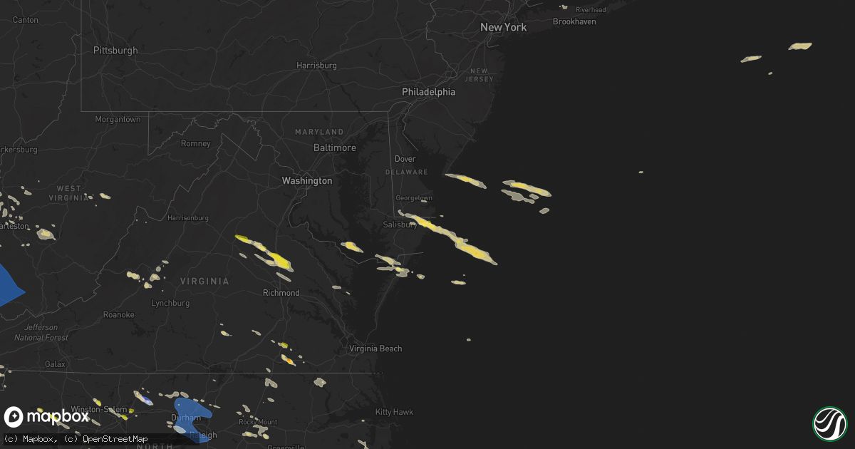
Hail Map on June 17, 2022
Get this storm
June 17 map
$229
one time, instant access
Download today. No call, no setup
Keep the $229
Bought the map and want the full workflow? Apply the entire $229 to a subscription within 7 days. None of it is wasted.
Every map, not just this one
This buys you this map. Subscription and you get every map we run, in the markets you choose from a few cities to whole states to nationwide. Plus real-time alerts the moment a storm fires.
Contact data
Name, contact info, occupancy, even credit band for addresses in the footprint. You go from where it hit to who to call.
Become the source they trust
Unlimited branding weather history reports on demand. You already have the documented answer ready for the property owner, and you are the one who showed up with it.
Property data and RoofTrace estimates
Pull up any address you have got, its value and the exact code rules for that jurisdiction, straight from One Click Code. Then RoofTrace estimates the squares, pitch, and roof value, priced the way you price.
States Impacted by Hail Map on June 17, 2022
Storm reports
Rhode Island
| Date | Description |
|---|---|
| 06/17/20222:09 PM CDT | Two trees down on robin hollow road in west greenwich. Relayed by amateur radio. |
| 06/16/202210:03 PM CDT | At 301 PM EDT, severe thunderstorms were located along a line extending from near West Greenwich to near Ledyard Center, moving east at 25 mph. HAZARD...60 mph wind gusts and quarter size hail. SOURCE...Radar indicated. IMPACT...Minor hail damage to vehicles is possible. Expect wind damage to trees and power lines. Locations impacted include... Jewett City, Norwich, Colchester, Salem, Ledyard, Griswold, Lebanon, Preston, Lisbon, Sprague, Bozrah, Voluntown, Ledyard Center, Montville and North Stonington. |
Missouri
| Date | Description |
|---|---|
| 06/17/20227:36 AM CDT | At 1235 AM CDT, severe thunderstorms were located along a line extending from near Clarksdale to near Agency to near Rushville, moving southeast at 50 mph. HAZARD...60 mph wind gusts. SOURCE...Radar indicated. IMPACT...Expect damage to roofs, siding, and trees. Locations impacted include... Cameron, Smithville, Plattsburg, Lathrop, Gower, Stewartsville, Agency, Trimble, Edgerton, Dearborn, Camden Point, Osborn, Easton, De Kalb, Turney, Ridgely and Faucett.This includes the following highways... Interstate 35 in Missouri between mile markers 37 and 52. Interstate 29 between mile markers 24 and 41. |
| 06/17/20222:49 AM CDT | At 749 AM CDT, severe thunderstorms were located along a line extending from near Sturgis to Golconda to near Mound City, moving southeast at 40 mph. HAZARD...60 mph wind gusts. SOURCE...Radar indicated. IMPACT...Expect damage to roofs, siding, and trees. Severe thunderstorms will be near... Joy around 755 AM CDT. Wickliffe and Burna around 800 AM CDT.Other locations in the path of these severe thunderstorms includeSalem, Lovelaceville and Eddyville.This includes Interstate 24 in Kentucky between Mile Markers 1 and24, and between Mile Markers 27 and 41. |
| 06/17/202212:07 AM CDT | At 507 AM CDT, severe thunderstorms were located along a line extending from near South Roxana to St. Louis to Pacific, moving east at 35 mph. HAZARD...60 mph wind gusts and penny size hail. SOURCE...Trained weather spotters. IMPACT...Expect damage to roofs, siding, and trees. Severe thunderstorms will be near... Granite City, Cahokia, Pontoon Beach, Dupo, Madison, Venice, Cahokia Parks Airport, Lemay, Brooklyn and East Carondelet around 515 AM CDT. Edwardsville, Maryville, Centreville, Fairmont City and Alorton around 520 AM CDT. East St. Louis, Glen Carbon, Troy and Washington Park around 525 AM CDT.Other locations in the path of these severe thunderstorms includeCollinsville, Fairview Heights, Caseyville, High Ridge, Belleville,Swansea, Shiloh, Fenton, Murphy, Antonia, St. Jacob, Marine,O'Fallon, Arnold, Barnhart, Highland, Lebanon, Lakeshire, Scott AFB,Green Park, Imperial, Sappington, Concord, Oakville, Mehlville, St.George, Valmeyer, Bella Villa and Fountain.This includes the following highways... Interstate 70 in Illinois between exits 21 and 30. Interstate 55 in Illinois near exit 23. Interstate 64 in Illinois between exits 9 and 27. Interstate 44 in Missouri between exits 251 and 277. Interstate 55 in Missouri between exits 178 and 191.This also includes Route 66 State Park, Castlewood State Park,Mastodon Historic Site, Sandy Creek Covered Bridge Historic Site,Gov. Dunklin's Grave Historic Site, Robertsville State Park, andHorseshoe Lake State Park. |
| 06/16/202211:40 PM CDT | At 440 AM CDT, severe thunderstorms were located along a line extending from Roodhouse to near Carrollton to Hardin to near Chain of Rocks, moving east at 40 mph. HAZARD...60 mph wind gusts and penny size hail. SOURCE...Radar indicated. IMPACT...Expect damage to roofs, siding, and trees. Severe thunderstorms will be near... Carrollton around 445 AM CDT. Greenfield around 450 AM CDT. Athensville around 455 AM CDT. St. Charles, Jerseyville and Old Kane around 500 AM CDT.Other locations in the path of these severe thunderstorms includeOrchard Farms, Bridgeton, Grafton, Elsah, Florissant, Hazelwood,Berkeley, Palmyra, Portage Des Sioux, Kemper, Ferguson, Carlinville,Dellwood, Brighton, Calverton Park and West Alton.This includes the following highways... Interstate 55 in Illinois between exits 23 and 44. Interstate 44 in Missouri between exits 261 and 277. Interstate 70 in Missouri between exits 208 and 231.This also includes Babler Memorial State Park, Scott Joplin HistoricSite, Route 66 State Park, Castlewood State Park, Confluence StatePark, First Missouri State Capitol Historic Site, Pere MarquetteState Park, Beaver Dam State Park, and Horseshoe Lake State Park. |
| 06/16/202211:04 PM CDT | At 404 AM CDT, severe thunderstorms were located along a line extending from near Buckhorn to near Pittsfield to Eolia, moving east at 70 mph. HAZARD...60 mph wind gusts. SOURCE...Radar indicated. IMPACT...Expect damage to roofs, siding, and trees. Severe thunderstorms will be near... Belleview around 415 AM CDT.Other locations in the path of these severe thunderstorms includeWhite Hall, Roodhouse, Carrollton, Athensville, Old Kane andGreenfield.This includes Interstate 72 near exit 35. |
| 06/16/202210:02 PM CDT | At 301 AM CDT, severe thunderstorms were located along a line extending from near Shelbina to near Madison to near Higbee, moving southeast at 45 mph. HAZARD...60 mph wind gusts and penny size hail. SOURCE...The Moberly ASOS reported a 58 mph wind gust. IMPACT...Expect damage to roofs, siding, and trees. Severe thunderstorms will be near... Shelbina, Madison, Woodlawn and Maud around 305 AM CDT. Granville around 310 AM CDT. Paris around 320 AM CDT.Other locations in the path of these severe thunderstorms includeSanta Fe, Mexico, Perry, Laddonia and Center.This also includes Union Covered Bridge Historic Site and Mark TwainLake Recreational Area. |
| 06/16/20229:56 PM CDT | At 256 AM CDT, a severe thunderstorm was located near Indian Lake Park, or 9 miles southeast of Keosauqua, moving southeast at 40 mph. HAZARD...60 mph wind gusts and quarter size hail. SOURCE...Radar indicated. IMPACT...Hail damage to vehicles is expected. Expect wind damage to roofs, siding, and trees. This severe thunderstorm will be near... Farmington and Indian Lake Park around 300 AM CDT. Anson, Shimek State Forest, Chambersburg and Primrose around 305 AM CDT. Croton and Battle of Athens Campground around 310 AM CDT. Donnellson, Revere, Peaksville and Lee County Fairgrounds around 315 AM CDT.Other locations in the path of this severe thunderstorm includeArgyle, Vincennes, Charleston, New Boston, St. Francisville, Nauvoo,Montrose, Summitville, Bluff Park, Nauvoo State Park, Keokuk,Alexandria, Sandusky, Keokuk Airport, Mooar, Galland and ChatfieldPark. |
| 06/16/20229:40 PM CDT | At 239 AM CDT, severe thunderstorms were located along a line extending from near Greensburg to La Plata, moving east at 25 mph. HAZARD...60 mph wind gusts and quarter size hail. SOURCE...Radar indicated. IMPACT...Hail damage to vehicles is expected. Expect wind damage to roofs, siding, and trees. Severe thunderstorms will be near... Greensburg around 250 AM CDT.Other locations in the path of these severe thunderstorms includeEdina, Knox City, Colony, La Belle, Shelbyville and Plevna. |
| 06/16/20228:49 PM CDT | At 149 AM CDT, severe thunderstorms were located along a line extending from near South Gorin to Greensburg to 8 miles southeast of Greentop, moving south at 20 mph. HAZARD...60 mph wind gusts and quarter size hail. SOURCE...Radar indicated. IMPACT...Hail damage to vehicles is expected. Expect wind damage to roofs, siding, and trees. Severe thunderstorms will be near... Colony around 205 AM CDT.Other locations in the path of these severe thunderstorms includeEdina and Knox City. |
| 06/16/20228:28 PM CDT | At 127 AM CDT, a severe thunderstorm was located over Bible Grove, or 7 miles southwest of Memphis, moving southeast at 35 mph. HAZARD...60 mph wind gusts and quarter size hail. SOURCE...Radar indicated. IMPACT...Hail damage to vehicles is expected. Expect wind damage to roofs, siding, and trees. This severe thunderstorm will be near... Greensburg and Spillman Mound around 140 AM CDT. Rutledge, South Gorin and Sand Hill around 145 AM CDT. |
| 06/16/20228:21 PM CDT | At 121 AM CDT, a severe thunderstorm was located 9 miles southeast of Princeton, or 18 miles northwest of Milan, moving southeast at 40 mph. HAZARD...60 mph wind gusts and nickel size hail. SOURCE...Radar indicated. IMPACT...Expect damage to roofs, siding, and trees. Locations impacted include... Milan, Princeton, Green City, Galt, Laredo, Newtown, Humphreys, Pollock, Lucerne, Harris, Powersville, Osgood, Mill Grove, Reger and Lemons. |
Indiana
| Date | Description |
|---|---|
| 06/17/202210:25 AM CDT | Trees and power lines down. |
| 06/17/202210:25 AM CDT | One tree down on aberdeen road. Another tree down on willow creek road. Time estimated from radar. |
| 06/17/20229:32 AM CDT | Social media picture of a large tree spit... And another tree downed at a residence along highway 62 north. |
| 06/17/20229:20 AM CDT | Nws employee reported several large limbs down and aluminum siding peeled down the side of a feed mill. Winds estimated at 60 to 65 mph. Time estimated from radar based |
| 06/17/20229:13 AM CDT | Tree damage. |
| 06/17/20229:08 AM CDT | Trees down on us-150. |
| 06/17/20229:00 AM CDT | Trees reported down across orange county. |
| 06/17/20229:00 AM CDT | Trees reported down across the western portion of washington county. |
| 06/17/20228:44 AM CDT | Public report - 3 inch tree limbs broken. |
| 06/17/20228:36 AM CDT | Tree down. |
| 06/17/20228:29 AM CDT | Roof damage at hoosier hills credit union. |
| 06/17/20228:26 AM CDT | Tree down. |
| 06/17/20228:24 AM CDT | Tree in roadway approx 3 miles east of sr162. |
| 06/17/20228:17 AM CDT | Power line blown over on us 231. |
| 06/17/20228:15 AM CDT | Tree down. |
| 06/17/20228:14 AM CDT | Several trees downed along lake greenwood. |
| 06/17/20228:10 AM CDT | Social media report of trees down in se daviess county. |
| 06/17/20228:09 AM CDT | Trees down blocking roadway. |
| 06/17/20228:08 AM CDT | Trees reported down on s 800 w by dispatch. |
| 06/17/20228:08 AM CDT | Trees reported down on w 625 s by dispatch. |
| 06/17/20228:00 AM CDT | Large power lines down. Time estimated. |
| 06/17/20228:00 AM CDT | Multiple trees down and/or snapped in residential area. |
| 06/17/20227:55 AM CDT | Public report via mping - 1 inch tree limbs broken... Shingles blown off. |
| 06/17/20227:54 AM CDT | Asos station kevv evansville in. |
| 06/17/20227:44 AM CDT | Public report via mping - 1 inch tree limbs broken... Shingles blown off. |
| 06/17/20227:43 AM CDT | Public report via mping - 1 inch tree limbs broken... Shingles blown off. |
| 06/17/20227:42 AM CDT | A local report indicates 65 MPH wind near 2 ESE EVANSVILLE |
| 06/17/20227:40 AM CDT | Several large trees and power lines are down. |
| 06/17/20227:36 AM CDT | Decker fire dept. Member reports trees breaking and estimates 60mph winds. |
| 06/17/20227:34 AM CDT | Em reports large... Healthy tree blocking road at intersection of 550 and camp arthur rd. |
| 06/17/20227:25 AM CDT | Tree down on a home. |
| 06/17/20224:25 AM CDT | At 925 AM EDT, severe thunderstorms were located along a line extending from near Bedford to 7 miles east of Jasper, moving east at 45 mph. HAZARD...60 mph wind gusts. SOURCE...Radar indicated. IMPACT...Expect damage to roofs, siding, and trees. Locations impacted include... English. |
| 06/17/20224:06 AM CDT | At 906 AM EDT, a severe thunderstorm was located 10 miles north of Shoals, or 15 miles west of Bedford, moving east at 40 mph. HAZARD...60 mph wind gusts and quarter size hail. SOURCE...Radar indicated. IMPACT...Hail damage to vehicles is expected. Expect wind damage to roofs, siding, and trees. This severe thunderstorm will be near... Williams, Silverville and Huron around 915 AM EDT.Other locations in the path of this severe thunderstorm includeMitchell, Spring Mill State Park and Tunnelton. |
| 06/17/20223:52 AM CDT | At 851 AM EDT, severe thunderstorms were located along a line extending from near Petersburg to 6 miles south of Winslow to near Boonville, moving southeast at 40 mph. HAZARD...60 mph wind gusts. SOURCE...Radar indicated. IMPACT...Expect damage to roofs, siding, and trees. Locations impacted include... Jasper. |
| 06/17/20221:44 AM CDT | At 644 AM CDT, severe thunderstorms were located along a line extending from near Bogota to near Schnell, moving east at 45 mph. HAZARD...60 mph wind gusts and penny size hail. SOURCE...Radar indicated. IMPACT...Expect damage to roofs, siding, and trees. Severe thunderstorms will be near... Dundas and West Liberty around 650 AM CDT. Olney and Ste. Marie around 655 AM CDT.Other locations in the path of these severe thunderstorms includeParkersburg, Calhoun, Chauncey, Hardinville, Lawrenceville, FlatRock, New Hebron, Birds, St. Francisville and Russellville. |
Florida
| Date | Description |
|---|---|
| 06/17/20227:00 AM CDT | At 1200 AM EDT, a severe thunderstorm was located 8 miles north of Carrabelle, moving west at 45 mph. HAZARD...60 mph wind gusts and penny size hail. SOURCE...Radar indicated. IMPACT...Expect damage to roofs, siding, and trees. Locations impacted include... East Camp, Poplar Camp, Morgan Place, Vilas, Mcintyre, Twin Pole, Sanborn, Curtis Mill, Owens Bridge, Fort Gadsden and Lanark Village. |
Kentucky
| Date | Description |
|---|---|
| 06/17/20221:22 PM CDT | A tree was blown down in the fleming neon area. |
| 06/17/20221:19 PM CDT | Trees and limbs were reported to have been blown down along us 460. The event time is radar estimated. |
| 06/17/20221:15 PM CDT | Trees were reported to have blown down along us 460 between mm 9 and 10. The event time is radar estimated. |
| 06/17/20221:12 PM CDT | Trees were reported to have been blown down along greasy creek road/ky 3226. |
| 06/17/20221:10 PM CDT | Trees were reported to have been blown down on ky 122 between mm 5 and 6. The event time is radar estimated. |
| 06/17/20221:10 PM CDT | A tree was down on ky 7 near deane. |
| 06/17/20221:10 PM CDT | Several trees and limbs were reported down in the eastern sections of harlan county in the cumberland vicinity. |
| 06/17/20221:08 PM CDT | Trees and limbs were reported to have been blown down in the burnwell community. The time of the event is radar estimated. |
| 06/17/20221:08 PM CDT | Trees were blown in and near hardy along ky 319. The time of the event is radar estimated. |
| 06/17/20221:07 PM CDT | A tree was reported to have been blown down onto ky 582. |
| 06/17/20221:06 PM CDT | Numerous trees and limbs were down between on ky 1460 between the pikeville city limits and the chloe community at the intersection at ky 1460 and us 460. The time of t |
| 06/17/20221:06 PM CDT | Straight line winds blew the metal roof of an auto sale business in belfry. The event time is radar estimated. |
| 06/17/20221:03 PM CDT | Straight line winds leveled an outbuilding to the south of us 119 at a double kwik gas station and a large portion of a billboard on north side of us 119 across from th |
| 06/17/20221:02 PM CDT | Trees and limbs were reported down in the vicinity of evarts. |
| 06/17/20221:02 PM CDT | Trees were reported to have been blown down in the sidney area. The event time is radar estimated. |
| 06/17/20221:00 PM CDT | Trees were reported down near the holly hills shopping center. |
| 06/17/202212:58 PM CDT | Trees were blown down and roofing material blew off a structure in the brookside community. |
| 06/17/202212:57 PM CDT | Dispatch reported a tree down on watson rd. Near plummers landing... Kentucky. Time established from dispatch call. |
| 06/17/202212:57 PM CDT | Dispatch reported a tree down on mcroberts rd. Near grange city... Kentucky. Time established from dispatch call. |
| 06/17/202212:56 PM CDT | Multiple large limbs down |
| 06/17/202212:56 PM CDT | Trees and limbs were reported to have been blown down onto ky 468 in the hatfield community. The event time is radar estimated. |
| 06/17/202212:55 PM CDT | Operators received report of lots of wind damage included damage to signs... Shingles removed... And tree limbs down... With debris in the road in downtown harlan in th |
| 06/17/202212:55 PM CDT | Tree down in south shore. Photo included with report on social media. |
| 06/17/202212:54 PM CDT | A tree was blown down onto ky 1087. The event time is radar estimated. |
| 06/17/202212:52 PM CDT | A tree was blown down onto ky highway 80. |
| 06/17/202212:50 PM CDT | 3 trees were reported to have been blown down in the lower johns creek area of pike county. The location and time of the event is estimated from radar. |
| 06/17/202212:50 PM CDT | Numerous trees and power lines were blown down along peter cave rd and pigeon roost rd in pilgrim. |
| 06/17/202212:48 PM CDT | Numerous trees and power lines were blown down along hode rd in warfield. |
| 06/17/202212:48 PM CDT | Numerous trees and power lines were blown down along riverfront rd in lovely. |
| 06/17/202212:44 PM CDT | Trees and a power line were blown down in helton. |
| 06/17/202212:41 PM CDT | Trees and limbs were reported to have been blown down via social media in the downtown area of inez. The even time is radar estimated. |
| 06/17/202212:41 PM CDT | Bell county dispatch reported trees blown down onto old bell high rd. |
| 06/17/202212:40 PM CDT | Numerous trees and power lines were blown down across all of martin county. As of 630 pm edt... Power was still out across most of the county. The city of inez was part |
| 06/17/202212:40 PM CDT | Bell county dispatch reported trees blown in kettle island. |
| 06/17/202212:40 PM CDT | Trees and power lines were blown down across the city of inez including at the following locations: main street... Route 908 and turkey creek rd... New route 3... Route |
| 06/17/202212:39 PM CDT | Numerous trees and power lines were blown down in tomahawk. |
| 06/17/202212:38 PM CDT | A tree was reported to have been blown down along straight fork. The even time is radar estimated. |
| 06/17/202212:37 PM CDT | Large tree uprooted and blown over near the corner of scott lane and dingus street. Time estimated from radar. |
| 06/17/202212:37 PM CDT | Corrects previous tstm wnd dmg report from 1 wsw prestonsburg. Large tree uprooted and blown over near the corner of scott lane and dingus street. Numerous other trees |
| 06/17/202212:37 PM CDT | A tree was blown down at the intersection of highways 66 and 2011 in beverly. Power outages across the county. |
| 06/17/202212:36 PM CDT | Bell county dimp rotary road in gastonia. |
| 06/17/202212:36 PM CDT | Bell county dispatch reported 3 instances of trees blown onto power lines in the city of pineville. |
| 06/17/202212:34 PM CDT | Several trees and limbs were reported to have been blown down in the auxier area. |
| 06/17/202212:34 PM CDT | Numerous trees and powerlines down across the county. |
| 06/17/202212:34 PM CDT | Several trees and limbs were reported to have been blow down along ky 850 and ky 404 in the david vicinity and elsewhere in the david fire department district. |
| 06/17/202212:34 PM CDT | Large limb down on woodland hills road. Time estimated from radar. |
| 06/17/202212:33 PM CDT | Numerous trees down along abbott creek road... Or kentucky highway 1427. Time estimated from radar. |
| 06/17/202212:33 PM CDT | A tree was blown down onto a home and large tree limbs were blown down. This report was via social media with a picture. |
| 06/17/202212:32 PM CDT | Knox county dispatch reported trees blown down onto power lines in the flat lick area. |
| 06/17/202212:32 PM CDT | Trees and powerlines were reported to have been blown down in and near thelma the event time is radar estimated. |
| 06/17/202212:32 PM CDT | Trees and powerlines were reported to have been blown down in and near tutor key. The event time is radar estimated. |
| 06/17/202212:32 PM CDT | Knox county dispatch reported trees blown down onto power lines in the alex creek area. |
| 06/17/202212:31 PM CDT | Numerous trees and limbs down in the middle creek fire district in the vicinity of dotson and. |
| 06/17/202212:30 PM CDT | Tree and limbs were reported to have been blown down. The event time is radar estimated. |
| 06/17/202212:30 PM CDT | Trees were reported down in the wittensville and nippa communities. The event time is radar estimated. |
| 06/17/202212:30 PM CDT | Trees and limbs were blown down. The event time is radar estimated. |
| 06/17/202212:30 PM CDT | A tree was reported to have been blown down. This report is via social media with a picture. The event time is radar estimated. |
| 06/17/202212:30 PM CDT | Corrects previous tstm wnd dmg report from paintsville. Several trees were reported to have been blown down. These report are via social media with pictures. The event |
| 06/17/202212:29 PM CDT | Utility poles snapped with trees and large limbs down in addition to downed powerlines on adams cemetery road and along ky 114. |
| 06/17/202212:28 PM CDT | Powerlines were blown down. |
| 06/17/202212:25 PM CDT | Large tree limbs were blown down along ky 114. |
| 06/17/202212:24 PM CDT | Trees and limbs were reported to have been blown down. The event time is radar estimated. |
| 06/17/202212:22 PM CDT | A tree was down on powerlines and caught on fire in the redbush and elna vicinity. The local vfd responded. The event time is estimated from radar. |
| 06/17/202212:21 PM CDT | Trees were reported to have been blown down near ky 7. The event time is radar estimated. |
| 06/17/202212:21 PM CDT | Trees were reported to have been blown down in the falcon community. |
| 06/17/202212:20 PM CDT | Several trees and powerlines down across the county. |
| 06/17/202212:20 PM CDT | Trees and limbs were blown down. The event time is radar estimated. |
| 06/17/202212:18 PM CDT | Tree down across highway 30 east of jackson. Time estimated from radar. |
| 06/17/202212:18 PM CDT | Tree down on highway 30 west of rousseau. Time estimated from radar. |
| 06/17/202212:16 PM CDT | Trees were reported to have been blown down in salyersville. The event time is radar estimated. |
| 06/17/202212:16 PM CDT | Large limb down on highway 30 near rousseau. |
| 06/17/202212:14 PM CDT | Large limbs were blown down along ky 172 in eastern morgan county. |
| 06/17/202212:14 PM CDT | Knox county dispatch reported trees blown down onto power lines along siler hill rd. |
| 06/17/202212:13 PM CDT | Trees were reported to have been blown down. The event time is radar estimated. |
| 06/17/202212:12 PM CDT | Trees were reported down in and in the vicinity of west liberty and elsewhere throughout morgan county. |
| 06/17/202212:12 PM CDT | Tree down on highway 30 near the magoffin and |
| 06/17/202212:12 PM CDT | Tree down on highway 30 near the magoffin and breathitt county line. Time estimated from radar. |
| 06/17/202212:11 PM CDT | Trees were reported down in the grape creek area of magoffin county. The event time is radar estimated. |
| 06/17/202212:09 PM CDT | Large tree down at corner of ribolt-epworth road and happy hollow road. Time estimated from radar data. |
| 06/17/202212:09 PM CDT | Trees were blown down in the horse creek community. The event time is radar estimated. |
| 06/17/202212:08 PM CDT | Elliott county dispatch reported trees blown down along ky-486. |
| 06/17/202212:07 PM CDT | A tree was down on the mountain parkway near adele. The event time is radar estimated. |
| 06/17/202212:06 PM CDT | A tree was reported to have been blown down on horse creek road in southern laurel county. The event time is radar estimated. |
| 06/17/202212:05 PM CDT | A tree was reported to have been blown down onto north stewart road. The event time is radar estimated. |
| 06/17/202212:04 PM CDT | A tree was reported to have been blown down onto curry road. |
| 06/17/202212:04 PM CDT | Elliott county dispatch reported trees blown down along ky-649. |
| 06/17/202212:04 PM CDT | Elliott county dispatch reported trees blown down along ky-504. |
| 06/17/202212:04 PM CDT | Elliott county dispatch reported trees blown down along ky-32 s. |
| 06/17/202212:04 PM CDT | Elliott county dispatch reported trees blown down along ky-719. |
| 06/17/202212:01 PM CDT | Golf ball size hail in fallsburg. |
| 06/17/202212:01 PM CDT | Elliott county dispatch reported trees blown down along ky-32 n. |
| 06/17/202212:00 PM CDT | A tree was reported blown down onto ky 312 in southern laurel county. The event time is radar estimated. |
| 06/17/202211:58 AM CDT | Route 8 near maysville closed due to tree damage. |
| 06/17/202211:58 AM CDT | Mccreary county 911 reported many trees down county wide including the community of pine knot. |
| 06/17/202211:57 AM CDT | Elliott county dispatch reported trees blown down onto power lines along ky-173 leading to a temporary road closure. |
| 06/17/202211:57 AM CDT | Corrects time of previous tstm wnd dmg report from wellington. Numerous trees were blown down in and around wellington and throughout the county. A few power outages we |
| 06/17/202211:56 AM CDT | Trees were blown down in ezel including onto 2 mobile homes. |
| 06/17/202211:54 AM CDT | Elliott county dispatch reported trees blown down along devils fork rd. |
| 06/17/202211:51 AM CDT | A large tree limb was down on a residence. |
| 06/17/202211:50 AM CDT | Route 324 closed due to tree damage. |
| 06/17/202211:49 AM CDT | A tree was reported to have been blown down onto london dock road. The event time is radar estimated. |
| 06/17/202211:48 AM CDT | A tree was blown down onto holly fork road in rowan county. This report is via social media with a picture. |
| 06/17/202211:48 AM CDT | A tree was blown down onto holly fork road in rowan county. This report is via |
| 06/17/202211:48 AM CDT | Powerlines were downed due to a snapped powerpole. This report was via social media with a picture. |
| 06/17/202211:47 AM CDT | A tree was blown down onto old flemingsburg road. The event time is radar estimated. |
| 06/17/202211:46 AM CDT | A tree was reported to have been blown down onto adams road. The event time is radar estimated. |
| 06/17/202211:45 AM CDT | Measured at a weather station located at the cave run marinas. |
| 06/17/202211:44 AM CDT | A tree was blown down onto a mobile home. The event time is radar estimated. |
| 06/17/202211:44 AM CDT | Numerous trees reported down by dispatch near and around campton. Time estimated by radar. |
| 06/17/202211:44 AM CDT | Corrects time from previous tstm wnd dmg report from frenchburg. Numerous trees were blown down in and around frenchburg and through out the county. A few power outages |
| 06/17/202211:42 AM CDT | Pulaski county dispatch reported trees blown down onto the ky-192 approximately 18 miles east of somerset. |
| 06/17/202211:41 AM CDT | Tree reported down near 500 hatchers creek rd in stanton... Ky. Time estimated by radar. |
| 06/17/202211:41 AM CDT | Powell county 911 call center reported a roof was blown off of an apartment complex in stanton... Kentucky. Time from when call came into dispatch. |
| 06/17/202211:41 AM CDT | A tree reported down near 9000 winchester rd. In clay city... Kentucky. Time estimated from radar. |
| 06/17/202211:41 AM CDT | A tree was reported to have blown down on a garage. The event time is radar estimated. |
| 06/17/202211:38 AM CDT | A tree was blown down onto a vehicle at the dollar general store in salt lick. |
| 06/17/202211:35 AM CDT | Pulaski county 911 reported trees blown down along hall ridge rd. |
| 06/17/202211:35 AM CDT | Pulaski county dispatch reported trees blown down along slate branch road. |
| 06/17/202211:35 AM CDT | Hay barn blown over... No injuries. |
| 06/17/202211:33 AM CDT | Pulaski county dispatch reported trees blown down along hickory nut rd. |
| 06/17/202211:31 AM CDT | Wayne county 911 reported 2 large trees blown down on ky-1275 n in the 600 block. Time estimated from radar. |
| 06/17/202211:31 AM CDT | Tree reported down on beech fork road near clay city... Ky. Time estimated from radar. |
| 06/17/202211:31 AM CDT | Wayne county 911 call center reported a large tree blown down across ky-167 in the 700 block. |
| 06/17/202211:30 AM CDT | Large tree limbs down at spring meadows drive and town branch road. |
| 06/17/202211:30 AM CDT | Tree down across the kroger bypass. |
| 06/17/202211:30 AM CDT | Dispatch reported a tree down on tar ridge rd. Near rogers... Kentucky. Time established from radar. |
| 06/17/202211:27 AM CDT | Trees and power lines down on powersville-harrison county road. Time estimated from radar. |
| 06/17/202211:26 AM CDT | Corrects previous tstm wnd dmg report from 1 sw grange city. Dispatch reported a tree down on mcroberts rd. Near grange city... Kentucky. Time established from dispatch |
| 06/17/202211:26 AM CDT | Corrects previous tstm wnd dmg report from 1 sw plummers landing. Dispatch reported a tree down on watson rd. Near plummers landing... Kentucky. Time established from d |
| 06/17/202211:25 AM CDT | Wayne county 911 call center reported large tree blown down onto ky-858 in the 1000 block. |
| 06/17/202211:24 AM CDT | Pulaski county dispatch reported trees blown down along bourbon rd. |
| 06/17/202211:23 AM CDT | Wayne county dispatch reported a large tree blown down onto utility lines along old susie rd. |
| 06/17/202211:20 AM CDT | Trees down over roadways across various parts of the county. |
| 06/17/202211:17 AM CDT | Roughly 20 trees reported down due to wind around the county. 3 transformer fires and numerous power outages were also reported. Time estimated from radar. |
| 06/17/202211:15 AM CDT | Several trees down in various parts of the county... Including the city of paris. |
| 06/17/202211:15 AM CDT | Several trees down in various parts of the county... Including the city of paris. |
| 06/17/202211:14 AM CDT | Tree down. |
| 06/17/202211:05 AM CDT | Roof damage to the smiser building in cynthiana. Multiple trees reported down in harrison county as well with a few causing road closures. Time estimated from radar. |
| 06/17/202210:58 AM CDT | Tree down on roadway. |
| 06/17/202210:57 AM CDT | Numerous trees were blown down in and around wellington and throughout the county. A few power outages were ongoing at 830 pm edt. |
| 06/17/202210:57 AM CDT | Trees down on gentry mill rd. |
| 06/17/202210:55 AM CDT | Trees down. |
| 06/17/202210:50 AM CDT | Trees down. |
| 06/17/202210:44 AM CDT | Numerous trees were blown down in and around frenchburg and through out the county. A few power outages were ongoing at 830 pm edt. |
| 06/17/202210:43 AM CDT | Delayed report. Measured 61 mph gust recorded at scott county eoc. |
| 06/17/202210:40 AM CDT | Trees... Power lines... And telephones reported down. |
| 06/17/202210:40 AM CDT | Corrects previous tstm wnd dmg report from 2 wnw georgetown. Tree down on golf course. |
| 06/17/202210:40 AM CDT | Trees down on hippe-agee rd. |
| 06/17/202210:40 AM CDT | Trees down on grassy springs rd. Between us-60 and ky-1659. |
| 06/17/202210:37 AM CDT | Corrects previous tstm wnd dmg report from 3 nnw stamping ground. Trees down across roadway. |
| 06/17/202210:35 AM CDT | Trees down on east side of franklin county. |
| 06/17/202210:35 AM CDT | Trees down. |
| 06/17/202210:35 AM CDT | Tree down on mobile home. |
| 06/17/202210:30 AM CDT | Trees down on us-62. |
| 06/17/202210:27 AM CDT | Large tree limbs down. |
| 06/17/202210:25 AM CDT | Tree down. |
| 06/17/202210:20 AM CDT | Damage to barn roof. |
| 06/17/202210:20 AM CDT | Tree down on golf course. |
| 06/17/202210:16 AM CDT | Tree and power lines on propane tank. |
| 06/17/202210:09 AM CDT | Trees and power lines reported down across simpson county. |
| 06/17/202210:04 AM CDT | Powerlines down 800 block of black jack rd. |
| 06/17/20229:50 AM CDT | Trees reported down. |
| 06/17/20229:30 AM CDT | Trees reported down. |
| 06/17/20229:30 AM CDT | Trees reported down. |
| 06/17/20229:30 AM CDT | Trees reported down. |
| 06/17/20229:26 AM CDT | Trees down across roadway. |
| 06/17/20229:00 AM CDT | Tree down across ky-79. |
| 06/17/20229:00 AM CDT | Several trees down east of murray. |
| 06/17/20229:00 AM CDT | Public report via mping - 1 inch tree limbs broken... Shingles blown off. |
| 06/17/20228:55 AM CDT | Awos station kcey murray ky. |
| 06/17/20228:47 AM CDT | Public mping report- trees uprooted or snapped. |
| 06/17/20228:39 AM CDT | Public report via mping. |
| 06/17/20228:30 AM CDT | A metal roof of a softball shed was removed... And sheet metal was thrown downwind. Time estimated from radar. Public report relayed by broadcast media. |
| 06/17/20228:30 AM CDT | Trees down on jack thomason rd just northwest of eddyville. |
| 06/17/20228:21 AM CDT | Public report via mping - 1 inch limbs broken. |
| 06/17/20228:12 AM CDT | Was still gusting 55 to 60 mph at time of report. |
| 06/17/20228:10 AM CDT | Estimated 55 to 60 mph winds. |
| 06/17/20228:05 AM CDT | Lots of large limbs down and power lines down throughout town. |
| 06/17/20227:53 AM CDT | At 1253 PM EDT, severe thunderstorms were located along a line extending from near Head of Grassy to Big Woods, moving southeast at 35 mph. HAZARD...60 mph wind gusts and penny size hail. SOURCE...Radar indicated. IMPACT...Expect damage to roofs, siding, and trees. Severe thunderstorms will be near... Zag around 100 PM EDT. |
| 06/17/20227:49 AM CDT | At 1249 PM EDT, a severe thunderstorm was located over Yatesville Lake State Park, moving east at 40 mph. HAZARD...60 mph wind gusts and penny size hail. SOURCE...Radar indicated. IMPACT...Expect damage to roofs, siding, and trees. Locations impacted include... Louisa, Wayne, Yatesville Lake State Park, Fort Gay, Ranger, Gill, East Lynn Lake, Kiahsville, Dunlow, Harts, Branchland, Fallsburg, East Lynn, Genoa, Myra and Glenhayes. |
| 06/17/20227:47 AM CDT | Public reported m59 mph wind gust - personal weather station. |
| 06/17/20227:46 AM CDT | Public report via mping - 1 inch tree limbs broken... Shingles blown off. |
| 06/17/20227:44 AM CDT | At 1244 PM EDT, a severe thunderstorm was located over Cornwell, or near Frenchburg, moving east at 40 mph. HAZARD...70 mph wind gusts and penny size hail. SOURCE...Radar indicated. IMPACT...Expect considerable tree damage. Damage is likely to mobile homes, roofs, and outbuildings. This severe thunderstorm will be near... Frenchburg around 1250 PM EDT. Mariba around 1255 PM EDT. Wellington around 100 PM EDT.Other locations in the path of this severe thunderstorm include Ezel,Murphyfork and Henry. |
| 06/17/20227:39 AM CDT | At 1239 PM EDT, a severe thunderstorm was located over High Falls, or near Campton, moving east at 35 mph. HAZARD...60 mph wind gusts and penny size hail. SOURCE...Radar indicated. IMPACT...Expect damage to roofs, siding, and trees. This severe thunderstorm will be near... Vortex around 1245 PM EDT. Baptist around 1250 PM EDT. Lexie around 1255 PM EDT.Other locations in the path of this severe thunderstorm include UpperGilmore, Belknap and Burg. |
| 06/17/20227:26 AM CDT | At 1226 PM EDT, a severe thunderstorm was located over Ringos Mills, or 11 miles southeast of Flemingsburg, moving east at 35 mph. HAZARD...60 mph wind gusts and penny size hail. SOURCE...Radar indicated. IMPACT...Expect damage to roofs, siding, and trees. This severe thunderstorm will be near... Plummers Landing around 1230 PM EDT. Sharkey around 1235 PM EDT. Hilda around 1240 PM EDT. Hays Crossing around 1245 PM EDT.Other locations in the path of this severe thunderstorm includeMorehead and Haldeman. |
| 06/17/20227:16 AM CDT | At 1215 PM EDT, severe thunderstorms were located along a line extending from 11 miles west of Fairview to near Sideview to near Winchester, moving east at 40 mph. HAZARD...60 mph wind gusts and penny size hail. SOURCE...Radar indicated. IMPACT...Expect damage to roofs, siding, and trees. Severe thunderstorms will be near... Sharpsburg around 1225 PM EDT. Flat Creek around 1230 PM EDT. Fairview around 1235 PM EDT.Other locations in the path of these severe thunderstorms includeOwingsville, Stanton and Flemingsburg. |
| 06/17/20227:10 AM CDT | At 1210 PM EDT, a severe thunderstorm was located near Klondike, or 8 miles southwest of Mount Sterling, moving east at 40 mph. HAZARD...60 mph wind gusts and penny size hail. SOURCE...Radar indicated. IMPACT...Expect damage to roofs, siding, and trees. This severe thunderstorm will be near... Klondike around 1215 PM EDT. Prewitt around 1220 PM EDT. Camargo around 1225 PM EDT. Jeffersonville around 1230 PM EDT.Other locations in the path of this severe thunderstorm include LuckyStop and Cedar Groves. |
| 06/17/20226:59 AM CDT | At 1159 AM EDT, severe thunderstorms were located along a line extending from 7 miles east of Owenton to 6 miles northwest of Georgetown to near Lawrenceburg, moving east at 50 mph. HAZARD...60 mph wind gusts and penny size hail. SOURCE...Radar indicated. IMPACT...Expect damage to roofs, siding, and trees. Locations impacted include... Veterans Park, Fayette Mall, U K Arboretum, Chevy Chase, Northland, Paris, Cynthiana, Cadentown, Winchester and Carlisle. |
| 06/17/20226:43 AM CDT | At 1143 AM EDT/1043 AM CDT/, a severe thunderstorm was located over Columbia, moving east at 40 mph. HAZARD...60 mph wind gusts and penny size hail. SOURCE...Radar indicated. IMPACT...Expect damage to roofs, siding, and trees. Locations impacted include... Jamestown. |
| 06/17/20226:37 AM CDT | At 1137 AM EDT, severe thunderstorms were located along a line extending from 13 miles northwest of Georgetown to 7 miles east of Frankfort to near Lawrenceburg, moving east at 40 mph. HAZARD...60 mph wind gusts and penny size hail. SOURCE...Radar indicated. IMPACT...Expect damage to roofs, siding, and trees. Severe thunderstorms will be near... Lexington and Georgetown around 1155 AM EDT.Other locations in the path of these severe thunderstorms includeHighlands, Nicholasville, Dunbar High School, Bryan Station,Thoroughbred Acres, Fayette Mall, U K Arboretum, Cardinal Hill,Meadowthorpe, Paris, Cynthiana, Veterans Park, Chevy Chase, Cadentownand Northland. |
| 06/17/20226:29 AM CDT | At 1127 AM EDT, a severe thunderstorm was located 14 miles northeast of Springfield, moving east at 35 mph. HAZARD...60 mph wind gusts and penny size hail. SOURCE...Radar indicated. IMPACT...Expect damage to roofs, siding, and trees. This severe thunderstorm will be near... Harrodsburg around 1145 AM EDT. |
| 06/17/20226:22 AM CDT | At 1121 AM EDT/1021 AM CDT/, a severe thunderstorm was located near Greensburg, and is moving eat at 35 mph. HAZARD...60 mph wind gusts and quarter size hail. SOURCE...Radar indicated. IMPACT...Hail damage to vehicles is expected. Expect wind damage to roofs, siding, and trees. Locations impacted include... Greensburg. |
| 06/17/20226:12 AM CDT | At 1112 AM EDT, a severe thunderstorm was located 7 miles northeast of Shelbyville, moving east at 40 mph. HAZARD...60 mph wind gusts and penny size hail. SOURCE...Radar indicated. IMPACT...Expect damage to roofs, siding, and trees. Locations impacted include... Frankfort. |
| 06/17/20226:08 AM CDT | At 1107 AM EDT, a severe thunderstorm was located 11 miles south of Versailles, moving east at 40 mph. HAZARD...60 mph wind gusts. SOURCE...Radar indicated. IMPACT...Expect damage to trees and power lines. Locations impacted include... Rising Sun, Warsaw, Florence, Pleasant, Glencoe, Fairview, Patriot, Center Square, Aberdeen, Interstate 71 at US Route 127, Waterloo, Steele Bottom, Markland, Avonburg, Moorefield, Farmers Retreat, Friendship, Rabbit Hash, Quercus Grove and Mount Sterling.This includes I-71 in Kentucky between mile markers 62 and 63. |
| 06/17/20225:02 AM CDT | At 1001 AM CDT, severe thunderstorms were located along a line extending from Portland to Nashville, moving east at 50 mph. HAZARD...60 mph wind gusts. SOURCE...Radar indicated. IMPACT...Expect damage to roofs, siding, and trees. Locations impacted include... Gallatin, Lebanon, Lafayette, Hartsville, Madison, Hendersonville, La Vergne, Mount Juliet, Goodlettsville, White House, Millersville, Lakewood, Westmoreland, Ridgetop, Cross Plains, Portland, Hermitage, Rural Hill, Belinda City and Old Hickory.This includes the following highways... Interstate 40 between mile markers 218 and 232. Interstate 65 between mile markers 92 and 112. |
| 06/17/20224:35 AM CDT | At 935 AM CDT, severe thunderstorms were located along a line extending from 10 miles west of Coopertown to 11 miles southeast of Clarksville to near Tennessee Ridge, moving southeast at 55 mph. HAZARD...60 mph wind gusts. SOURCE...Radar indicated. IMPACT...Expect damage to roofs, siding, and trees. Locations impacted include... Clarksville, Springfield, Dickson, Ashland City, Erin, Goodlettsville, White House, Millersville, Greenbrier, Coopertown, White Bluff, Kingston Springs, Pegram, Ridgetop, McEwen, Cross Plains, Burns, Tennessee Ridge, Joelton and Pleasant View. |
| 06/17/20224:34 AM CDT | At 934 AM EDT, a severe thunderstorm was located 8 miles west of Elizabethtown, moving east at 20 mph. HAZARD...Quarter size hail. SOURCE...Radar indicated. IMPACT...Damage to vehicles is expected. Locations impacted include... Elizabethtown. |
| 06/17/20224:20 AM CDT | At 920 AM CDT, a severe thunderstorm was located near Dunmor, moving southeast at 40 mph. HAZARD...60 mph wind gusts. SOURCE...Radar indicated. IMPACT...Expect damage to roofs, siding, and trees. This severe thunderstorm will remain over mainly rural areas of Logan and southwestern Butler Counties, including the following locations... Insco, Gordonsville, Dimple, Spa, Epleys, Leetown, Dennis, Wolf Lick, Crossroad and Buffalo Fork. |
| 06/17/20224:03 AM CDT | At 902 AM CDT, severe thunderstorms were located along a line extending from near Dunmor to 12 miles east of Murray, moving southeast at 45 mph. HAZARD...60 mph wind gusts and penny size hail. SOURCE...Radar indicated. IMPACT...Expect damage to roofs, siding, and trees. Locations impacted include... Clarksville, Dover, Guthrie, Big Rock, Adams, Cedar Hill, Cumberland City, Land Between The Lakes, Indian Mound, Palmyra and Woodlawn.This includes Interstate 24 between mile markers 1 and 16. |
| 06/17/20223:54 AM CDT | At 853 AM CDT, severe thunderstorms were located along a line extending from 9 miles north of Dunmor to near Hopkinsville to near Land Between The Lakes Area, moving southeast at 30 mph. HAZARD...60 mph wind gusts. SOURCE...Radar indicated. This is an extension to the previous warning. IMPACT...Expect damage to roofs, siding, and trees. Severe thunderstorms will be near... Hopkinsville and Dunmor around 910 AM CDT.This includes the following highways... Interstate 24 in Kentucky between Mile Markers 66 and 75. Western Kentucky Parkway between Mile Markers 54 and 65. Pennyrile Parkway between Mile Markers 7 and 20. |
| 06/17/20223:20 AM CDT | At 820 AM CDT, severe thunderstorms were located along a line extending from near Beech Grove to near Olney to near Eddyville, moving southeast at 40 mph. HAZARD...60 mph wind gusts. SOURCE...Radar indicated. IMPACT...Expect damage to roofs, siding, and trees. Severe thunderstorms will be near... Princeton around 840 AM CDT.Other locations in the path of these severe thunderstorms includeCrofton and Cobb.This includes the following highways... Interstate 24 in Kentucky between Mile Markers 42 and 75. Interstate 69 in Kentucky between Mile Markers 68 and 90. Pennyrile Parkway between Mile Markers 7 and 26. |
| 06/17/20223:14 AM CDT | At 813 AM CDT, severe thunderstorms were located along a line extending from Santa Claus to near St. Joseph, moving east at 45 mph. HAZARD...60 mph wind gusts. SOURCE...Radar indicated. IMPACT...Expect damage to roofs, siding, and trees. These severe thunderstorms will remain over mainly rural areas of southern Perry, Hancock, western Breckinridge and northeastern Ohio Counties, including the following locations... Frymire, Skillman, Goering, Ralph, Gerald, Tar Fork, Rome, Vanzant, Ellmitch and Arrington Corner. |
| 06/17/20223:06 AM CDT | At 806 AM CDT, severe thunderstorms were located along a line extending from near Hartford to near Central City to Madisonville, moving southeast at 20 mph. HAZARD...60 mph wind gusts. SOURCE...Radar indicated. IMPACT...Expect damage to roofs, siding, and trees. Locations impacted include... Central City, Powderly, Greenville, Nortonville, Graham and Dunmor.This includes the following highways... Interstate 69 in Kentucky between Mile Markers 101 and 110. Western Kentucky Parkway between Mile Markers 39 and 65. Pennyrile Parkway between Mile Markers 29 and 34. |
| 06/17/20222:32 AM CDT | At 731 AM CDT, severe thunderstorms were located along a line extending from Equality to 8 miles north of Dixon Springs to near Karnak, moving southeast at 50 mph. HAZARD...60 mph wind gusts and penny size hail. SOURCE...Radar indicated. IMPACT...Expect damage to roofs, siding, and trees. Severe thunderstorms will be near... Ridgway and Equality around 735 AM CDT. Shawneetown around 740 AM CDT. Golconda and New Columbia around 750 AM CDT.Other locations in the path of these severe thunderstorms includeMetropolis, Rosiclare and Brookport.This includes Interstate 24 in Illinois between Mile Markers 12 and38. |
| 06/17/20222:26 AM CDT | At 726 AM CDT, severe thunderstorms were located along a line extending from near St. Francisville to Owensville to 6 miles south of New Harmony, moving east at 50 mph. HAZARD...60 mph wind gusts and penny size hail. SOURCE...Radar indicated. IMPACT...Expect damage to roofs, siding, and trees. Locations impacted include... Lynnville, Petersburg, Newburgh, Chandler, Folsomville and Boonville.This includes the following highways... Interstate 69 in Indiana between Mile Markers 6 and 7, near MileMarker 22, and between Mile Markers 38 and 52. Interstate 64 in Indiana between Mile Markers 30 and 54. |
| 06/16/20229:06 PM CDT | At 205 PM EDT, a severe thunderstorm was located over Diane, or 16 miles northeast of Harlan, moving east at 30 mph. HAZARD...60 mph wind gusts and penny size hail. SOURCE...Radar indicated. IMPACT...Expect damage to roofs, siding, and trees. This severe thunderstorm will remain over mainly rural areas of northwestern Harlan, southeastern Leslie, southwestern Letcher and southeastern Perry Counties. |
| 06/16/20229:03 PM CDT | At 203 PM EDT, a severe thunderstorm was located over Gordon, or 14 miles southwest of Whitesburg, moving east at 45 mph. HAZARD...60 mph wind gusts and penny size hail. SOURCE...Radar indicated. IMPACT...Expect damage to roofs, siding, and trees. Locations impacted include... Cumberland, Evarts, Lynch, Benham, Flint, Totz, Black Bottom, Dizney, Louellen, Clover Fork, Lewis Creek and Defeated Creek. |
| 06/16/20228:48 PM CDT | At 148 PM EDT, a severe thunderstorm was located near South Webster, moving southeast at 35 mph. HAZARD...60 mph wind gusts and penny size hail. SOURCE...Radar indicated. IMPACT...Expect damage to trees and power lines. Locations impacted include... Wheelersburg, South Webster, Lyra and Powellsville. |
| 06/16/20228:41 PM CDT | At 141 PM EDT, a severe thunderstorm was located over Asher, or 9 miles south of Hyden, moving east at 30 mph. HAZARD...60 mph wind gusts and penny size hail. SOURCE...Radar indicated. IMPACT...Expect damage to roofs, siding, and trees. This severe thunderstorm will be near... Mozelle around 145 PM EDT. Chappell around 150 PM EDT. Napier around 200 PM EDT.Other locations in the path of this severe thunderstorm include BigLaurel, Pine Mountain and Totz. |
| 06/16/20228:35 PM CDT | At 134 PM EDT, a severe thunderstorm was located over Ulysses, or 8 miles northeast of Paintsville, moving east at 35 mph. HAZARD...60 mph wind gusts. SOURCE...Radar indicated. IMPACT...Expect damage to roofs, siding, and trees. Locations impacted include... Ulysses, Charley and Crum. |
| 06/16/20228:28 PM CDT | At 128 PM EDT, a severe thunderstorm was located near Yatesville Lake State Park, moving east at 35 mph. HAZARD...60 mph wind gusts. SOURCE...Radar indicated. IMPACT...Expect damage to roofs, siding, and trees. Locations impacted include... Louisa, Yatesville Lake State Park, Fort Gay, Dunlow, East Lynn Lake, Gallup, Fallsburg, East Lynn, Genoa, Clifford and Glenhayes. |
| 06/16/20228:16 PM CDT | At 116 PM EDT, a severe thunderstorm was located over Webbville, or near Grayson Lake State Park, moving east at 50 mph. HAZARD...60 mph wind gusts. SOURCE...Radar indicated. IMPACT...Expect damage to roofs, siding, and trees. Locations impacted include... Denton, Webbville, Houckville, Willard and Hitchins. |
| 06/16/20228:11 PM CDT | At 111 PM EDT, severe thunderstorms were located along a line extending from Teges to Park Valley, moving east at 50 mph. HAZARD...60 mph wind gusts and penny size hail. SOURCE...Radar indicated. IMPACT...Expect damage to roofs, siding, and trees. Locations impacted include... Manchester, Hyden, Hoskinston, Grace, Shoal, Brightshade, Lake, Treadway, Goose Rock, Barcreek, Bush and Chestnutburg. |
| 06/16/20228:08 PM CDT | At 108 PM EDT, severe thunderstorms were located along a line extending from Steele to Portsmouth, moving southeast at 25 mph. HAZARD...60 mph wind gusts and penny size hail. SOURCE...Radar indicated. IMPACT...Expect damage to roofs, siding, and trees. Severe thunderstorms will be near... Press around 115 PM EDT. Moon around 125 PM EDT.Other locations in the path of these severe thunderstorms includeMima, Buck, Win and Elmrock. |
| 06/16/20228:03 PM CDT | At 103 PM EDT, a severe thunderstorm was located over Mashfork, or near Salyersville, moving east at 30 mph. HAZARD...60 mph wind gusts and penny size hail. SOURCE...Radar indicated. IMPACT...Expect damage to roofs, siding, and trees. This severe thunderstorm will be near... Ballot around 110 PM EDT. Swamp Branch around 115 PM EDT. Leander around 120 PM EDT.Other locations in the path of this severe thunderstorm include EastPoint and Prestonsburg. |
Virginia
| Date | Description |
|---|---|
| 06/17/20226:55 PM CDT | Large tree limb downed on to road along us-13 near exmore. Time radar estimated. |
| 06/17/20226:55 PM CDT | Trees down on powerlines. |
| 06/17/20226:51 PM CDT | Trees down on powerlines. |
| 06/17/20226:47 PM CDT | Updates previous hail report from bloxom. Also... A few large tree limbs were downed into a garden at this location. Time radar estimated. |
| 06/17/20225:40 PM CDT | Trees downed along i-85 near mm 21. Time radar estimated. |
| 06/17/20225:25 PM CDT | Multiple trees uprooted along route 30 in king william. One tree fell through roof of house. |
| 06/17/20225:23 PM CDT | Ping pong ball size hail reported along us-58 12 miles east of emporia. |
| 06/17/20225:20 PM CDT | Shingles blown off roof of house in central garage. |
| 06/17/20225:15 PM CDT | Trees downed along us-460 east of burkesville... With numerous power outages in the area. Time radar estimated. |
| 06/17/20225:15 PM CDT | Corrects previous tstm wnd dmg report from 1 ese nutbush. Trained spotter reports numerous large trees downed... Including a couple onto outbuildings near battes roads |
| 06/17/20225:10 PM CDT | Large tree uprooted on tomlinson road in victoria. Time estimated from radar. |
| 06/17/20224:56 PM CDT | A couple of trees down in the area of massies mill... Va. |
| 06/17/20224:55 PM CDT | Several trees down across the county. |
| 06/17/20224:55 PM CDT | Tree down on gully tavern road in rice. |
| 06/17/20224:52 PM CDT | Tree down at new bethel road and dempsey road in meherrin. Time estimated from radar. |
| 06/17/20224:45 PM CDT | Tree downed along i-95 at mile marker 104... With another leaning toward roadway/into traffic at mile marker 105. |
| 06/17/20224:45 PM CDT | Tree down on ligontown road in cumberland. |
| 06/17/20224:44 PM CDT | Reports of multiple large trees uprooted in the ladysmith area near route 1. Also damage to outbuilding from fallen trees. |
| 06/17/20224:40 PM CDT | A couple outbuildings damaged with trees also uprooted at a farm along jericho road near ruther glen. Time is radar estimated. |
| 06/17/20224:39 PM CDT | Tree down on five forks road in pamplin. |
| 06/17/20224:39 PM CDT | Tree down on brickett road in farmville. |
| 06/17/20224:33 PM CDT | Tree down on prince edward highway in prospect. |
| 06/17/20224:26 PM CDT | Tree down on power line on brook st. |
| 06/17/20224:26 PM CDT | Tree down on a house on old richmond road. |
| 06/17/20224:20 PM CDT | One tree down on a powerline on moorefield bridge rd. |
| 06/17/20224:18 PM CDT | Tree down on stubbs bridge rd. Near the lake anna bridge. |
| 06/17/20224:17 PM CDT | Power lines down on stage rd in concord va. |
| 06/17/20224:17 PM CDT | Power lines down near the farmers bank of appomattox on village hwy. |
| 06/17/20224:17 PM CDT | Power line down on pettigrew drive near concord va. |
| 06/17/20224:17 PM CDT | Power lines and trees down in road on bear creek rd. |
| 06/17/20224:16 PM CDT | Tree down on buck creek road. |
| 06/17/20224:15 PM CDT | Tree down on spring grove road. |
| 06/17/20224:15 PM CDT | Trees downed at intersection of lew jones road and manson church road. Time radar estimated. |
| 06/17/20224:15 PM CDT | Tree down blocking spring grove road. |
| 06/17/20224:14 PM CDT | Tree down at the intersection of boggs dr. And stage coach rd. |
| 06/17/20224:13 PM CDT | A couple of trees down in the area of rockfish... Va. |
| 06/17/20224:11 PM CDT | Tree down... Blocking the road on stage rd. |
| 06/17/20224:08 PM CDT | Telephone pole down on stage road. |
| 06/17/20224:05 PM CDT | Tree down in road... Blocking one lane. Near intersection of robertsons ridge rd and sandy river rd. |
| 06/17/20224:05 PM CDT | Tree down at the intersection of creekview ln. Thomas nelson hwy. |
| 06/17/20224:05 PM CDT | Power line down on the concord turnpike. |
| 06/17/20224:05 PM CDT | Multiple trees down around the city of lynchburg. |
| 06/17/20224:05 PM CDT | Tree down in the 2200 block of piedmont rd. |
| 06/17/20224:04 PM CDT | Report from mping: 1-inch tree limbs broken; shingles blown off. |
| 06/17/20224:02 PM CDT | Tree down at the intersection of tye river rd. And boxwood farm rd. |
| 06/17/20224:01 PM CDT | Multiple reports of trees down between arringotn and colleen... Va. |
| 06/17/20224:00 PM CDT | Top of pine tree snapped off in city of lynchburg. |
| 06/17/20224:00 PM CDT | Large tree branch down. |
| 06/17/20224:00 PM CDT | Tree down in the 1300 block of beech grove rd. |
| 06/17/20224:00 PM CDT | Updates previous tstm wnd dmg report from amherst. Around 60 trees down around amherst county... Including a tree on a home on highway 130. 6...000 customers without po |
| 06/17/20224:00 PM CDT | 35 to 40 trees down around city of amherst reported by emergency manager. |
| 06/17/20223:58 PM CDT | Tree down in the 400 block of woodward rd. |
| 06/17/20223:56 PM CDT | Tree in middle of road. Near intersection of island ct and club house rd. |
| 06/17/20223:55 PM CDT | Power lines blew down near the 210 block of oak park rd. |
| 06/17/20223:54 PM CDT | Large trees down on sedgewick drive. One tree significantly damaged a house. |
| 06/17/20223:53 PM CDT | Tree fell on power line and is hanging over a driveway. |
| 06/17/20223:53 PM CDT | A tree blew down near n blue ridge turnpike and hebron ct. |
| 06/17/20223:53 PM CDT | Tree down across road near intersection of kings mountain rd and daniels creek rd. |
| 06/17/20223:50 PM CDT | A few trees down along marquee rd. Between monrovia rd. And double w farm rd. |
| 06/17/20223:50 PM CDT | Multiple large trees down on baileys sawmill road. |
| 06/17/20223:47 PM CDT | Large limbs down. 6 inches in diameter. Trampoline blew away and damaged. |
| 06/17/20223:45 PM CDT | Tree down on powerline on rockford road. |
| 06/17/20223:45 PM CDT | One tree down... Blocking roadway on memorial blvd. |
| 06/17/20223:45 PM CDT | Tree down on powerline on rockford road. |
| 06/17/20223:45 PM CDT | Powerline and trees down on kings mountain road. |
| 06/17/20223:43 PM CDT | Tree down on blackberry road... Completely blocking roadway. |
| 06/17/20223:40 PM CDT | A tree blew down near sunnyview dr and us hwy 340. |
| 06/17/20223:36 PM CDT | Large trees down along route 221 in willis va. |
| 06/17/20223:35 PM CDT | Numerous trees and powerlines down throughout the entire county. |
| 06/17/20223:30 PM CDT | *** 1 inj *** one person was taken to a hospital after being hit by a blown down tree in the 100 block of lakewood court. |
| 06/17/20223:30 PM CDT | Trees down in the town of ferrum. |
| 06/17/20223:30 PM CDT | Tree down at the intersection of spotswood trail and nicholson rd. |
| 06/17/20223:30 PM CDT | Numerous trees and powerlines down countywide in rockbridge county. |
| 06/17/20223:27 PM CDT | A tree blew down near the 210 block of back rd. |
| 06/17/20223:27 PM CDT | A tree blew down near the 130 block of fleeburg loop. |
| 06/17/20223:26 PM CDT | Tree down in the 16000 block of naked creek rd. |
| 06/17/20223:20 PM CDT | Large limbs down near galax. |
| 06/17/20223:15 PM CDT | A local report indicates 58 MPH wind near GALAX HILLSVILLE AIRPOR |
| 06/17/20223:15 PM CDT | Large maple tree down... Split at ground in woodlawn va. |
| 06/17/20223:15 PM CDT | Tree down and intermittent power outages on placid lane. |
| 06/17/20223:15 PM CDT | Multiple trees down on beagle club road. |
| 06/17/20223:15 PM CDT | A local report indicates 58 MPH wind near GALAX HILLSVILLE AIRPOR |
| 06/17/20223:12 PM CDT | Power poles blown down on south franklin st in christiansburg. |
| 06/17/20223:10 PM CDT | Roofing on a deck was damaged in christiansburg. |
| 06/17/20223:07 PM CDT | Multiple trees down along dobbins hollow road. 04) 2336 w 4 n denmark |
| 06/17/20223:07 PM CDT | Thunderstorm winds blew down numerous trees and power lines... Mainly across the southern portion of bath county between 4:03 and 4:20 pm. One tree fell on a truck in h |
| 06/17/20223:07 PM CDT | Multiple trees down along dobbins hollow road. |
| 06/17/20223:06 PM CDT | Multiple trees down on betty drive in christiansburg. |
| 06/17/20223:05 PM CDT | Tree down on rocky road in bent mountain. |
| 06/17/20223:00 PM CDT | Scattered trees and powerlines down countywide. Crux of damage occurred between 3:40-4:15 pm. |
| 06/17/20223:00 PM CDT | Scattered trees and powerlines down across the south and east part of the county. |
| 06/17/20222:58 PM CDT | Report from mping: 3-inch tree limbs broken; power poles broken. |
| 06/17/20222:58 PM CDT | Several large limbs and trees snapped at 3:58 p.m. |
| 06/17/20222:58 PM CDT | Trees broken. |
| 06/17/20222:58 PM CDT | Large tree branch broken. |
| 06/17/20222:58 PM CDT | Uprooted trees. |
| 06/17/20222:56 PM CDT | Report from mping: 1-inch tree limbs broken; shingles blown off. |
| 06/17/20222:55 PM CDT | Thunderstorm winds brought down numerous trees and power lines across alleghany county... Including trees down across u.s. Highway 220 and state highway 687. Near iron |
| 06/17/20222:55 PM CDT | Numerous trees were blown down by thunderstorm winds between 3:55 pm and 4:20 pm across botetourt county... With the large majority in the northern portion of the count |
| 06/17/20222:50 PM CDT | A local report indicates 65 MPH wind near 1 SSE BLACKSBURG |
| 06/17/20222:50 PM CDT | Tree down blocking happy hollow road. Power outages in woodbine/wyatt farms area also from downed trees/powerlines. Wind gust of 39 mph recorded at the vt airport |
| 06/17/20222:45 PM CDT | 1/2 of bradley pear tree in the street at the intersection of west main and berkeley street. No vehicles involved. |
| 06/17/20222:40 PM CDT | A local report indicates 62 MPH wind near 1 E MOUNTAIN LAKE |
| 06/17/20222:35 PM CDT | Scattered trees and powerlines down throughout the northwest part of the county from saltville to rich valley and from saltville to chilhowie. |
| 06/17/20222:34 PM CDT | Multiple trees and power lines down across county. |
| 06/17/20222:30 PM CDT | Multiple trees down throughout the county. |
| 06/17/20221:50 PM CDT | Multiple trees and powerlines down across the town. |
| 06/17/20221:45 PM CDT | Trees and power lines down county wide. Time estimated from radar. |
| 06/17/20227:52 AM CDT | At 1252 AM EDT, severe thunderstorms were located along a line extending from near Indian Mills to Oakvale to near War, moving southeast at 20 mph. HAZARD...60 mph wind gusts and quarter size hail. SOURCE...Radar indicated. IMPACT...Hail damage to vehicles is expected. Expect wind damage to roofs, siding, and trees. Locations impacted include... Bluefield... Princeton... Tazewell... Pearisburg... Narrows... Pembroke... and Athens.This includes The following Location Mercer County Airport. |
| 06/17/20227:38 AM CDT | At 1238 AM EDT, a severe thunderstorm was located over Cloverdale, or near Vinton, moving southeast at 20 mph. HAZARD...60 mph wind gusts and quarter size hail. SOURCE...Radar indicated. IMPACT...Hail damage to vehicles is expected. Expect wind damage to roofs, siding, and trees. Locations impacted include... Roanoke... Vinton... Troutville... Stewartsville... Montvale... Hollins... and Northwest Smith Mountain Lake.This includes The following Location Roanoke Regional Airport. |
| 06/17/20227:28 AM CDT | At 1228 AM EDT, severe thunderstorms were located along a line extending from near Hix to near Natural Bridge, moving southeast at 20 mph. HAZARD...60 mph wind gusts. SOURCE...Radar indicated. IMPACT...Expect damage to roofs, siding, and trees. Locations impacted include... Alleghany... Covington... Lewisburg... Hinton... White Sulphur Springs... Ronceverte... and Alderson.This includes The following Location The West Virginia StateFairgrounds. |
| 06/17/20227:04 AM CDT | At 1204 AM EDT, a severe thunderstorm was located near Pilot, moving southeast at 20 mph. HAZARD...60 mph wind gusts and quarter size hail. SOURCE...Radar indicated. IMPACT...Hail damage to vehicles is expected. Expect wind damage to roofs, siding, and trees. Locations impacted include... Floyd... Woolwine... Pilot... Alum Ridge... and Charity. |
| 06/17/20223:28 AM CDT | At 827 PM EDT, a severe thunderstorm was located over Norfolk NAS, or over Old Dominion University, moving east at 45 mph. HAZARD...60 mph wind gusts and quarter size hail. SOURCE...Radar indicated. IMPACT...Minor damage to vehicles is possible. Expect wind damage to trees and powerlines. This severe thunderstorm will be near... Virginia Wesleyan University and Norfolk International around 835 PM EDT. Kempsville and Regent University around 840 PM EDT. Virginia Beach around 850 PM EDT.Other locations impacted by this severe thunderstorm include RudeeHeights, Princess Anne Plaza, Oceana NAS, Macons Corner, RaleighTerrace, Bayside, Oceana, Wards Corner, North Virginia Beach and DamNeck. |
| 06/17/20222:33 AM CDT | At 732 PM EDT, severe thunderstorms were located along a line extending from near Tangier to 11 miles northwest of Nassawadox to near Bavon, moving east at 45 mph. HAZARD...60 mph wind gusts. SOURCE...Radar indicated. IMPACT...Expect damage to trees and powerlines. Severe thunderstorms will be near... Nassawadox around 745 PM EDT. Exmore, Cape Charles and Willis Wharf around 750 PM EDT. Onancock, Cheriton and Bay View around 755 PM EDT. Parksley around 800 PM EDT.Other locations impacted by these severe thunderstorms includeCapeville, Kiptopeke State Park, Harborton, Melfa, Eastville,Franktown, Cheapside, Kiptopeke, Painter and Keller. |
| 06/17/20222:31 AM CDT | At 730 PM EDT, severe thunderstorms were located along a line extending from near Courtland to near Conway to near Tarboro, moving southeast at 45 mph. HAZARD...60 mph wind gusts. SOURCE...Radar indicated. IMPACT...Expect damage to trees and powerlines. Severe thunderstorms will be near... Aulander around 745 PM EDT. Ahoskie and Como around 750 PM EDT. Winton around 755 PM EDT. Cofield around 800 PM EDT.Other locations impacted by these severe thunderstorms includeEagletown, Milwaukee, Kelford, Earleys, Menola, Chowan Beach,Mapleton, Republican, Jackson and Burden. |
| 06/17/20221:11 AM CDT | At 610 PM EDT, a severe thunderstorm was located near Green Plain, or 8 miles east of Emporia, moving southeast at 30 mph. HAZARD...60 mph wind gusts and quarter size hail. SOURCE...Radar indicated. IMPACT...Minor damage to vehicles is possible. Expect wind damage to trees and powerlines. This severe thunderstorm will be near... Claresville around 620 PM EDT. Boykins around 640 PM EDT. Conway around 655 PM EDT. Murfreesboro and Chowan University around 700 PM EDT.Other locations impacted by this severe thunderstorm includeMilwaukee, Adams Grove, Grizzard, Yale, Mapleton, Bryants Corner,Worrell, Hilda, Sunbeam and Creeksville. |
| 06/17/20221:08 AM CDT | At 608 PM EDT, a severe thunderstorm was located over Coles Point, or near White Point Beach, moving east at 55 mph. HAZARD...60 mph wind gusts. SOURCE...Radar indicated. IMPACT...Expect damage to trees and powerlines. This severe thunderstorm will remain over mainly rural areas of east central Westmoreland County, including the following locations... Westmoreland, Currioman Landing, Sandy Point and Erica. |
| 06/17/202212:58 AM CDT | At 558 PM EDT, severe thunderstorms were located along a line extending from near Lakeside Village to near Morven to near Green Bay, moving east at 45 mph. HAZARD...60 mph wind gusts. SOURCE...Radar indicated. IMPACT...Expect damage to trees and powerlines. Severe thunderstorms will be near... Morven, Jetersville and Ballsville around 605 PM EDT. Amelia Courthouse around 610 PM EDT. Nottoway, Chula and Scotts Fork around 615 PM EDT. Powhatan, Blackstone and Macon around 620 PM EDT. Mannboro and Fort Pickett around 625 PM EDT.Other locations impacted by these severe thunderstorms include NorthWellville, Irby, Rock Castle, Earls, Pilkinton, Murdocks, Forkland,Winterham, Wellville and Maplewood. |
| 06/17/202212:38 AM CDT | At 538 PM EDT, severe thunderstorms were located along a line extending from 6 miles east of Massaponax to 8 miles southeast of Bumpass to near Ferncliff, moving southeast at 30 mph. HAZARD...60 mph wind gusts and quarter size hail. SOURCE...Radar indicated. IMPACT...Minor damage to vehicles is possible. Expect wind damage to trees and powerlines. Severe thunderstorms will be near... Montpelier around 545 PM EDT. Bowling Green, Milford and Fort A.p. Hill around 550 PM EDT. Ashland and Kings Dominion around 555 PM EDT. Randolph Macon College, Gum Spring and Dawn around 600 PM EDT. Hanover, Glen Allen and Laurel around 605 PM EDT. Goochland, Mechanicsville, Oilville and Lakeside around 610 PM EDT. Richmond, Newtown, Studley, Beulahville and East Highland Park around 615 PM EDT. Sabot around 620 PM EDT.Other locations impacted by these severe thunderstorms includeChilesburg, Orchid, Gum Tree, Etna Mills, Chamberlayne, Atlee,Ashcake, Nancy Wrights Corner, Ruther Glen and Duane Fork. |
| 06/17/202212:38 AM CDT | At 538 PM EDT, a severe thunderstorm was located 8 miles north of Bumpass, or 10 miles northeast of Mineral, moving east at 40 mph. HAZARD...60 mph wind gusts and quarter size hail. SOURCE...Radar indicated. IMPACT...Damaging winds will cause some trees and large branches to fall. This could injure those outdoors, as well as damage homes and vehicles. Roadways may become blocked by downed trees. Localized power outages are possible. Unsecured light objects may become projectiles. Locations impacted include... Glenora, Partlow and Gatewood. |
| 06/17/202212:33 AM CDT | At 532 PM EDT, severe thunderstorms were located along a line extending from 8 miles north of Centenary to Dillwyn to near Sheppards to near Red House, moving east at 40 mph. HAZARD...60 mph wind gusts. SOURCE...Radar indicated. IMPACT...Expect damage to trees and powerlines. Severe thunderstorms will be near... Farmville and Guinea Mills around 545 PM EDT. Cumberland and Longwood University around 550 PM EDT. Fork Union around 555 PM EDT. Hampden Sydney College, Hampden Sydney, Sunnyside and Rice around 600 PM EDT. Duncan and Lakeside Village around 605 PM EDT. Cartersville and Green Bay around 615 PM EDT.Other locations impacted by these severe thunderstorms include RainesTavern, Tuggle, Prince Edward Station, Angola, Briery, Oak Forest,Twin Lakes State Park, Shores, Central Plains and Bremo Bluff. |
| 06/17/202212:25 AM CDT | At 522 PM EDT, a line of severe thunderstorms extended from north of Danville Virginia to near Greensboro North Carolina, moving to the southeast at 40 to 50 mph. HAZARD...60 mph wind gusts. SOURCE...Radar indicated. IMPACT...Expect damage to roofs, siding, and trees. Locations impacted include... South Boston... Halifax... Brookneal... Prospect Hill... Turbeville... Ingram... and Clover. |
| 06/17/202212:13 AM CDT | At 512 PM EDT, a severe thunderstorm was located near McKenney, moving southeast at 40 mph. HAZARD...60 mph wind gusts and quarter size hail. SOURCE...Radar indicated. IMPACT...Minor damage to vehicles is possible. Expect wind damage to trees and powerlines. This severe thunderstorm will be near... Dinwiddie around 520 PM EDT. Jarratt and Stony Creek around 540 PM EDT. Sussex around 550 PM EDT.Other locations impacted by this severe thunderstorm include Gray,Booker, Yale, Lumberton, Wharfs Store, Huske, Littleton, Hilda,Center Star and Owens. |
| 06/17/202212:12 AM CDT | At 512 PM EDT, severe thunderstorms were located along a line extending from 6 miles southeast of Wintergreen to Oakville, moving east at 50 mph. HAZARD...60 mph wind gusts. SOURCE...Radar indicated. IMPACT...Damaging winds will cause some trees and large branches to fall. This could injure those outdoors, as well as damage homes and vehicles. Roadways may become blocked by downed trees. Localized power outages are possible. Unsecured light objects may become projectiles. Locations impacted include... Shipman, Schuyler, Nellysford, Arrington, Scottsville, Esmont, Lovingston, Damon, Allens Creek, Covesville, Rockfish, Buffalo Springs, Norwood, Glendower, Keene, Five Forks, Wingina, Gladstone, Elma and Faber. |
| 06/17/202212:11 AM CDT | At 510 PM EDT, severe thunderstorms were located along a line extending from near Appomattox to Long Island, moving east at 75 mph. HAZARD...60 mph wind gusts. SOURCE...Radar indicated. IMPACT...Expect damage to roofs, siding, and trees. Locations impacted include... Brookneal... Keysville... Charlotte Court House... Phenix... Redoak... Red House... and Concord. |
| 06/16/202211:53 PM CDT | At 451 PM EDT, severe thunderstorms were located along a line extending from Stuarts Draft to Buena Vista, to Elon and Boonsvoro, moving east at 45 mph. HAZARD...70 mph wind gusts. SOURCE...Radar indicated. IMPACT...Expect considerable tree damage. Damage is likely to mobile homes, roofs, and outbuildings. Locations impacted include... Lynchburg... Buckingham... Amherst... Appomattox... Dillwyn... Forks Of Buffalo... and Bent Creek. |
| 06/16/202211:51 PM CDT | At 451 PM EDT, a severe thunderstorm was located near Madison, moving east at 40 mph. HAZARD...60 mph wind gusts. SOURCE...Radar indicated. IMPACT...Damaging winds will cause some trees and large branches to fall. This could injure those outdoors, as well as damage homes and vehicles. Roadways may become blocked by downed trees. Localized power outages are possible. Unsecured light objects may become projectiles. Locations impacted include... Orange, Madison, Brightwood, Mine Run, Oakpark, Everona, Verdiersville, Haywood, Montpelier Station, Locust Grove, Thornhill, Nasons, Madison Mills, Montford, Mitchells, Old Somerset, Unionville, Locust Dale, Raccoon Ford and Rhoadesville. |
| 06/16/202211:40 PM CDT | At 440 PM EDT, a severe thunderstorm was located near Luray, or 11 miles southeast of Woodstock, moving east at 35 mph. HAZARD...60 mph wind gusts. SOURCE...Radar indicated. IMPACT...Damaging winds will cause some trees and large branches to fall. This could injure those outdoors, as well as damage homes and vehicles. Roadways may become blocked by downed trees. Localized power outages are possible. Unsecured light objects may become projectiles. Locations impacted include... Sperryville, Washington, Kimball, Castleton, Compton, Viewtown, Woodville, Amissville, Fourway, Five Forks, Panorama, Rock Mills, Cardova, Rileyville and Boston. |
| 06/16/202211:31 PM CDT | At 431 PM EDT, a severe thunderstorm was located over Orange, moving east at 35 mph. HAZARD...60 mph wind gusts. SOURCE...Radar indicated. IMPACT...Damaging winds will cause some trees and large branches to fall. This could injure those outdoors, as well as damage homes and vehicles. Roadways may become blocked by downed trees. Localized power outages are possible. Unsecured light objects may become projectiles. Locations impacted include... Orange, Spotsylvania, Brokenburg, Montpelier Station, Madison Run, Snell, Alsop, Gatewood, Thornhill, Nasons, Logan, Partlow, Montford, Lahore, Glenora, Post Oak, Thornburg, Unionville, Somerset and Madison Mills. |
| 06/16/202211:24 PM CDT | At 424 PM EDT, severe thunderstorms were located along a line extending from near Bells Valley to Collierstown to near Snowden, moving southeast at 45 mph. HAZARD...60 mph wind gusts. SOURCE...Trained weather spotters. IMPACT...Damaging winds will cause some trees and large branches to fall. This could injure those outdoors, as well as damage homes and vehicles. Roadways may become blocked by downed trees. Localized power outages are possible. Unsecured light objects may become projectiles. Locations impacted include... Stuarts Draft, Sherando, Shipman, Schuyler, Wintergreen, Montebello, Lyndhurst, Nellysford, Craigsville, Greenville, Arrington, Scottsville, Esmont, Lovingston, Middlebrook, Allens Creek, North Garden, Covesville, Tyro and Buffalo Springs. |
| 06/16/202211:22 PM CDT | At 421 PM EDT, severe thunderstorms were located along a line extending from near Floyd to near Galax, Virginia, moving east- southeast at 50 mph. HAZARD...60 mph wind gusts. SOURCE...Radar indicated. IMPACT...Expect damage to roofs, siding, and trees. Locations impacted include... Mount Airy... Elkin... Fairview... Flat Rock... Dobson... Pilot Mountain... and Stuart. |
| 06/16/202211:18 PM CDT | At 418 PM EDT, a severe thunderstorm was located near Shenandoah, or 8 miles northeast of Harrisonburg, moving southeast at 30 mph. HAZARD...60 mph wind gusts. SOURCE...Radar indicated. IMPACT...Damaging winds will cause some trees and large branches to fall. This could injure those outdoors, as well as damage homes and vehicles. Roadways may become blocked by downed trees. Localized power outages are possible. Unsecured light objects may become projectiles. Locations impacted include... Madison, Shenandoah, Massanutten, Stanardsville, Big Meadows, Elkton, Ruckersville, Ingham, Quinque, Lydia, Haywood, Syria, Banco, Hood, Mcmullen, Criglersville, Lacey Spring, Swift Run, Pine Grove and Shelby. |
| 06/16/202211:15 PM CDT | At 413 PM EDT, severe thunderstorms were located along a line extending from Vesuvius to near Wirtz to near Indian Valley, moving southeast at 50 mph. HAZARD...70 mph wind gusts. SOURCE...Radar indicated. IMPACT...Expect considerable tree damage. Damage is likely to mobile homes, roofs, and outbuildings. Locations impacted include... Roanoke... Lynchburg... Salem... Vinton... Buena Vista... Bedford... and Rocky Mount.This includes The following Locations The Salem Fairgrounds, TheNational D-Day Memorial, and Roanoke Regional Airport. |
| 06/16/202211:14 PM CDT | At 414 PM EDT, a severe thunderstorm was located near Monterey, moving southeast at 30 mph. HAZARD...60 mph wind gusts. SOURCE...Radar indicated. IMPACT...Damaging winds will cause some trees and large branches to fall. This could injure those outdoors, as well as damage homes and vehicles. Roadways may become blocked by downed trees. Localized power outages are possible. Unsecured light objects may become projectiles. Locations impacted include... Monterey, Augusta Springs, Churchville, Deerfield, Hightown, Clover Creek, Doe Hill, Head Waters, Liberty, West Augusta, Buffalo Gap, Mustoe, Mcdowell, Trimbles Mill, Vanderpool, Sirons Mill, Christian and Swoope. |
| 06/16/202211:00 PM CDT | At 400 PM EDT, severe thunderstorms were located along a line extending from Merrimac to near Pulaski, moving southeast at 50 mph. HAZARD...60 mph wind gusts. SOURCE...Radar indicated. IMPACT...Expect damage to roofs, siding, and trees. Locations impacted include... Blacksburg... Christiansburg... Radford... Pulaski... Dublin... Floyd... and Newport.This includes The following Location Virginia Tech. |
| 06/16/202210:37 PM CDT | At 337 PM EDT, severe thunderstorms were located along a line extending from near Bristol Va to 7 miles south of Pine Crest, moving east at 45 mph. HAZARD...60 mph wind gusts and quarter size hail. SOURCE...Radar indicated. IMPACT...Hail damage to vehicles is expected. Expect wind damage to roofs, siding, and trees. Locations impacted include... Boone... Jefferson... West Jefferson... Blowing Rock... Beech Mountain... Lansing... and Foscoe.This includes The following Location Appalachian State University. |
| 06/16/202210:32 PM CDT | At 331 PM EDT, severe thunderstorms were located along a line extending from near Mechanicsburg to near Nebo, moving east at 70 mph. HAZARD...60 mph wind gusts and quarter size hail. SOURCE...Radar indicated. IMPACT...Hail damage to vehicles is expected. Expect wind damage to roofs, siding, and trees. Locations impacted include... Pulaski... Wytheville... Bland... Marion... Saltville... Rural Retreat... and Ceres. |
| 06/16/202210:25 PM CDT | At 324 PM EDT, a severe thunderstorm was located over Walnut Hill, or over Bristol Tn, moving southeast at 45 mph. HAZARD...60 mph wind gusts and quarter size hail. SOURCE...Radar indicated. IMPACT...Hail damage to vehicles is expected. Expect wind damage to roofs, siding, and trees. Locations impacted include... Bristol Tn, Bristol Va, Mountain City, Walnut Hill, Bluff City, Hunter, Morril's Cave, Neva, Sadie and Elk Mills.Those attending Bristol Dragway are in the path of this storm and should prepare for IMMINENT DANGEROUS WEATHER CONDITIONS. SEEK SHELTER NOW!This includes the following highways... Interstate 81 in Tennessee between mile markers 70 and 75. Interstate 81 in Virginia between mile markers 1 and 8. |
| 06/16/202210:02 PM CDT | At 301 PM EDT, severe thunderstorms were located along a line extending from near Richwood to Abingdon, moving southeast at 55 mph. HAZARD...60 mph wind gusts. SOURCE...Radar indicated. IMPACT...Expect damage to roofs, siding, and trees. Locations impacted include... Bluefield... Bland... Princeton... Richlands... Tazewell... Lewisburg... and Pearisburg.This includes The following Locations The West Virginia StateFairgrounds and Mercer County Airport. |
| 06/16/202210:00 PM CDT | At 300 PM EDT, severe thunderstorms were located along a line extending from near Camden-On-gauley to near Cedar Grove, moving southeast at 55 mph. HAZARD...70 mph wind gusts and nickel size hail. SOURCE...Radar indicated. IMPACT...Expect considerable tree damage. Damage is likely to mobile homes, roofs, and outbuildings. Locations impacted include... Charleston, Summersville, Fayetteville, Richwood, Babcock State Park, Oak Hill, Montgomery, Ansted, Belle, Cedar Grove, East Bank, Glasgow, Smithers, Gauley Bridge, Pratt, Camden-On-gauley, Powellton, Hawks Nest State Park, Craigsville and Coal Fork.This includes the following highways... West Virginia Turnpike between mile markers 91 and 94. Route 19 between mile markers 11 and 46. |
| 06/16/20229:36 PM CDT | At 235 PM EDT, a severe thunderstorm was located over Linefork, or 8 miles southwest of Whitesburg, moving east at 40 mph. HAZARD...60 mph wind gusts and quarter size hail. SOURCE...Radar indicated. IMPACT...Hail damage to vehicles is expected. Expect wind damage to roofs, siding, and trees. Locations impacted include... Norton, Wise, Coeburn, Pound and Pardee. |
| 06/16/20228:59 PM CDT | At 158 PM EDT, severe thunderstorms were located along a line extending from near Madison to 8 miles northwest of Holden to Threeforks, moving east at 45 mph. HAZARD...60 mph wind gusts. SOURCE...Radar indicated. IMPACT...Expect damage to roofs, siding, and trees. Locations impacted include... Williamson, Madison, Logan, Oak Hill, Oceana, Chapmanville, Man, Delbarton, Van, Gilbert Creek, Mount Gay-Shamrock, Mallory, Burnwell, Hinch, R.d. Bailey Lake, Bald Knob, Chief Logan State, Holden, Amherstdale-Robinette and Red Jacket.This includes the following highways... West Virginia Turnpike between mile markers 53 and 68. Route 119 between mile markers 1 and 55. Route 19 between mile markers 9 and 14. |
| 06/16/20228:59 PM CDT | At 158 AM EDT, a severe thunderstorm was located over Blacksburg, moving southeast at 20 mph. HAZARD...60 mph wind gusts. SOURCE...Radar indicated. IMPACT...Expect damage to roofs, siding, and trees. Locations impacted include... Blacksburg... Christiansburg... Radford... Newport... Pilot... Shawsville... and Bent Mountain.This includes The following Location Virginia Tech. |
| 06/16/20228:23 PM CDT | At 122 AM EDT, a severe thunderstorm was located near White Gate, or 10 miles west of Poplar Hill, moving southeast at 25 mph. HAZARD...60 mph wind gusts and quarter size hail. SOURCE...Radar indicated. IMPACT...Hail damage to vehicles is expected. Expect wind damage to roofs, siding, and trees. Locations impacted include... Pulaski... Dublin... Allisonia... Patterson... Long Spur... Mechanicsburg... and Claytor Lake State Park. |
| 06/16/20228:21 PM CDT | At 121 PM EDT, a severe thunderstorm was located over Lilley Cornett Woods, or 9 miles west of Whitesburg, moving east at 40 mph. HAZARD...60 mph wind gusts and penny size hail. SOURCE...Radar indicated. IMPACT...Expect damage to roofs, siding, and trees. This severe thunderstorm will be near... Flint around 125 PM EDT. Oscaloosa around 130 PM EDT. Whitesburg around 135 PM EDT. Eolia around 140 PM EDT. |
| 06/16/20227:01 PM CDT | Large tree down blocking road at 18274 metompkin rd. Time estimated by radar. |
Connecticut
| Date | Description |
|---|---|
| 06/17/20222:26 PM CDT | Spotter reported quarter size hail on dudley street. |
| 06/17/20221:30 PM CDT | Tree on to house on 170 block of kemp road; tree and wires down at three locations on kemp road; tree and wires down on cemetery road... And brooklyn turnpike. Relayed |
New Hampshire
| Date | Description |
|---|---|
| 06/17/202212:04 PM CDT | Several trees down on governors road. |
| 06/17/202212:04 PM CDT | Numerous trees down on nh hwy 75 east farmington near the turnpike interchange. Biggest trees were ~12 inches in diameter. Time estimated by radar. |
| 06/17/202211:55 AM CDT | Hail between 1 and 1.25 inches began at 12:55. Several trees down along hwy 153 |
| 06/17/202211:40 AM CDT | North of alton on nh highway 28. Fell for 4-5 minutes. |
Mississippi
| Date | Description |
|---|---|
| 06/17/20223:50 PM CDT | Tree downed along ms hwy 1 near benoit. |
| 06/17/20223:12 PM CDT | Power lines downed on litton rd. |
| 06/17/20222:11 PM CDT | A local report indicates 1.00 inch wind near 6 W SULLIGENT |
| 06/17/20222:11 PM CDT | Dime to quarter size hail reported in greenwood springs. |
| 06/17/20222:08 PM CDT | Dime to quarter size hail. |
| 06/17/20222:00 PM CDT | Quarter-sized hail on clay-tilden road in the clay community. |
| 06/17/202212:30 PM CDT | Large tree down in yard. |
| 06/17/20227:04 AM CDT | At 1204 PM CDT, a severe thunderstorm was located near Savannah, moving south at 15 mph. HAZARD...60 mph wind gusts and quarter size hail. SOURCE...Radar indicated. IMPACT...Hail damage to vehicles is expected. Expect wind damage to roofs, siding, and trees. Locations impacted include... Savannah, J P Coleman State Park, Pickwick Landing State Park, Pickwick Dam, Pineflat, Shiloh, Counce, Damon, Doskie, Southside, Hamburg, Pollards Mill, Bruton Branch, Pittsburg Landing, Childers Hill, Maddox, Hurley, Walkertown, Winn Springs and Red Sulphur Springs. |
| 06/16/202210:10 PM CDT | At 309 PM CDT, a severe thunderstorm was located over Shaw, moving south at 10 mph. HAZARD...60 mph wind gusts and quarter size hail. SOURCE...Radar indicated. IMPACT...Hail damage to vehicles is expected. Expect wind damage to roofs, siding, and trees. This severe thunderstorm will be near... Shaw around 320 PM CDT. |
| 06/16/20229:45 PM CDT | At 245 PM CDT, a severe thunderstorm was located over Crews, or over Sulligent, moving southeast at 20 mph. HAZARD...Ping pong ball size hail and 60 mph wind gusts. SOURCE...Radar indicated. IMPACT...People and animals outdoors will be injured. Expect hail damage to roofs, siding, windows, and vehicles. Expect wind damage to roofs, siding, and trees. Locations impacted include... Vernon, Sulligent, Beaverton, Blooming Grove, Lamar County Airport, Crews, Bedford, Crossville, Gattman, Cody, Lamar County Public Lake, Star, Pine Springs and Hightogy. |
| 06/16/20229:15 PM CDT | At 215 PM CDT, a severe thunderstorm was located 7 miles northwest of Bedford, or 7 miles west of Sulligent, moving east at 15 mph. HAZARD...Quarter size hail. SOURCE...Trained weather spotters. IMPACT...Damage to vehicles is expected. Locations impacted include... Gattman, Splunge, Athens, Sipsey Fork and Greenwood Springs. |
| 06/16/20229:09 PM CDT | At 208 PM CDT, a severe thunderstorm was located 7 miles northwest of Bedford, or 8 miles west of Sulligent, moving southeast at 10 mph. HAZARD...Golf ball size hail and 60 mph wind gusts. SOURCE...Radar indicated. IMPACT...People and animals outdoors will be injured. Expect hail damage to roofs, siding, windows, and vehicles. Expect wind damage to roofs, siding, and trees. Locations impacted include... Vernon, Sulligent, Detroit, Beaverton, Blooming Grove, Lamar County Airport, Crews, Bedford, Crossville, Cody, Henson Springs, Lamar County Public Lake, Star, Pine Springs and Hightogy. |
| 06/16/20229:04 PM CDT | At 204 PM CDT, a severe thunderstorm was located over Red Bay, moving south at 20 mph. HAZARD...60 mph wind gusts and half dollar size hail. SOURCE...Radar indicated. IMPACT...Hail damage to vehicles is expected. Expect wind damage to roofs, siding, and trees. Locations impacted include... Red Bay, Vina and Halltown. |
Georgia
| Date | Description |
|---|---|
| 06/17/20226:56 PM CDT | Tree reported down near the intersection of lover's lane and valentine rd. |
| 06/17/20226:56 PM CDT | Screven county 911 reported a tree down on hiltonia creek rd. |
| 06/17/20226:54 PM CDT | Tree down on roberts drive. |
| 06/17/20226:49 PM CDT | Tree reported down on ogletree rd. |
| 06/17/20226:48 PM CDT | Multiple trees down in milledgeville. |
| 06/17/20226:48 PM CDT | Multiple trees down along p a johns road. |
| 06/17/20226:48 PM CDT | 10 power lines and 20 trees down across milledgeville. |
| 06/17/20226:48 PM CDT | Multiple trees and powerlines down just north of milledgeville. |
| 06/17/20226:46 PM CDT | Tree reported down on the 200 block of river ridge trail. |
| 06/17/20226:45 PM CDT | A tree was downed on rock springs at hall road. |
| 06/17/20226:43 PM CDT | Tree reported down on captains ct. |
| 06/17/20226:39 PM CDT | A tree was downed onto power lines on lake joy road. |
| 06/17/20226:36 PM CDT | Burke county dispatch reported numerous trees down in sardis. Time estimated by radar. |
| 06/17/20226:36 PM CDT | Burke county dispatch reported numerous trees down in girard. Time estimated by radar. |
| 06/17/20226:33 PM CDT | Estimated 80 ft tree uprooted and fell on a home on coosa drive. |
| 06/17/20226:33 PM CDT | Several trees downed on property on ogeechee ct. |
| 06/17/20226:31 PM CDT | A tree was downed onto highway 96 at waterford drive. |
| 06/17/20226:20 PM CDT | Burke county dispatch reported trees down in east waynesboro along cates-mead road. Time estimated by radar. |
| 06/17/20226:10 PM CDT | Multiple trees were downed along seven islands road. |
| 06/17/20226:09 PM CDT | A tree was downed on little river road. |
| 06/17/20226:05 PM CDT | A tree was downed on aqua road. |
| 06/17/20225:38 PM CDT | Two trees down on a house along industrial park blvd ne near old georgetown road |
| 06/17/20225:20 PM CDT | Numerous trees were downed... Some onto power lines and blocking roads... Including on atkinson road... Natalie court... Plantation place... Brookview road... And highw |
| 06/17/20225:20 PM CDT | Several trees were downed across horseshoe road. |
| 06/17/20225:15 PM CDT | A tree fell across both lanes of fair street... Onto power lines... And onto a house. |
| 06/17/20224:55 PM CDT | Quarter size hail reported in lawrenceville. |
| 06/17/20224:50 PM CDT | Trees and powerlines downed on roadway in the winding woods neighborhood off of lavista rd in tucker. |
| 06/17/20224:45 PM CDT | A tree was downed onto a home on danbury drive nw. |
| 06/17/20224:45 PM CDT | A tree was downed onto a home on westberry lane nw. |
| 06/17/20224:40 PM CDT | A tree was downed onto a structure on suwanee mill drive. |
| 06/17/20224:40 PM CDT | A tree was downed onto a structure on chappell circle nw. |
| 06/17/20224:32 PM CDT | Powerlines and tree fell onto vehicle on atlanta st. In roswell. No injuries. |
| 06/17/20224:29 PM CDT | Quarter sized hail was reported at the mr. Clean car wash on highway 20. |
| 06/17/20224:17 PM CDT | A tree was downed onto a home near the intersection of post oak tritt road and johnson ferry road. |
| 06/17/20224:02 PM CDT | A tree and power lines were downed across bells ferry road between victoria road and port victoria way. |
| 06/17/20224:02 PM CDT | *** 1 inj *** one minor injury was reported when a tree fell onto a mobile home off of victoria road near bells ferry road. |
| 06/17/20223:35 PM CDT | A tree was downed on castleberry bridge road near robins way. |
| 06/17/20223:25 PM CDT | A tree was downed on camp road at donna lynn street. |
| 06/17/20223:14 PM CDT | A tree was downed on highway 53 at garrison road. |
| 06/17/20222:45 PM CDT | A tree was downed on highway 282 near pleasant gap road. |
| 06/17/20222:45 PM CDT | A tree was downed on highway 282 near gunstock creek road. |
| 06/17/20226:55 AM CDT | Numerous trees and power lines down across the county. |
| 06/17/20226:39 AM CDT | At 1139 PM EDT, severe thunderstorms were located along a line extending from 6 miles northwest of Race Pond to 10 miles west of Woodbine to near Waverly, moving southeast at 50 mph. The storms have a history of producing damage. HAZARD...60 mph wind gusts. SOURCE...Radar indicated. IMPACT...Expect damage to roofs, siding, and trees. Locations impacted include... St. Marys, Kingsland, Fernandina Beach, Hilliard, Folkston, Woodbine, Kings Bay Base, Yulee, Homeland and Kings Ferry. |
| 06/17/20226:16 AM CDT | At 1116 PM EDT, severe thunderstorms were located along a line extending from near Jamestown to near Nahunta to near Thalmann, moving southeast at 30 mph. These storms have a history of producing damage. HAZARD...60 mph wind gusts. SOURCE...Radar indicated. IMPACT...Expect damage to roofs, siding, and trees. Locations impacted include... Brunswick, Waycross, St. Simons Island, Nahunta, Dock Junction, Hickox, Country Club Estates, Boggy Bay, Thalmann and Sea Island. |
| 06/17/20225:41 AM CDT | At 1040 PM EDT, severe thunderstorms were located along a line extending from near Nicholls to 7 miles north of Bristol to near Gardi, moving southeast at 35 mph. HAZARD...60 mph wind gusts. SOURCE...Radar indicated. IMPACT...Expect damage to roofs, siding, and trees. Locations impacted include... Waycross, Jesup, Alma, Blackshear, Nahunta, Patterson, Gardi, Screven, Offerman and Pebble Hill. |
| 06/17/20225:12 AM CDT | At 1012 PM EDT, severe thunderstorms were located along a line extending from near Graham to near Donald, moving southeast at 25 mph. HAZARD...60 mph wind gusts and penny size hail. SOURCE...Radar indicated. IMPACT...Expect damage to roofs, siding, and trees. Locations impacted include... Jesup, Baxley, Alma, Surrency, Odum and Doctortown. |
| 06/17/20225:04 AM CDT | At 1004 PM EDT, severe thunderstorms were located along a line extending from Windsor Forest to Jesup, moving southeast at 40 mph. HAZARD...60 mph wind gusts and nickel size hail. SOURCE...Radar indicated. IMPACT...Expect damage to trees and powerlines. Locations impacted include: Hinesville, Pooler, Richmond Hill, Darien, Ludowici, Tibet, Coffee Bluff, Fort Stewart, Windsor Forest, Jones, McIntosh, Montgomery, Walthourville, Bloomingdale and Midway.This warning includes the following interstates: I-16 between mile markers 149 and 154. I-95 in Georgia between mile markers 50 and 98. |
| 06/17/20225:02 AM CDT | At 1002 PM EDT, a severe thunderstorm was located near Snipesville, or 7 miles west of Hazlehurst, moving southeast at 20 mph. HAZARD...60 mph wind gusts and penny size hail. SOURCE...Radar indicated. IMPACT...Expect damage to roofs, siding, and trees. This severe thunderstorm will remain over mainly rural areas of southwestern Jeff Davis County. |
| 06/17/20224:51 AM CDT | At 951 PM EDT, a severe thunderstorm was located near Hazlehurst, moving southeast at 20 mph. HAZARD...60 mph wind gusts and penny size hail. SOURCE...Radar indicated. IMPACT...Expect damage to roofs, siding, and trees. Locations impacted include... Hazlehurst. |
| 06/17/20224:18 AM CDT | At 918 PM EDT, a severe thunderstorm was located near Abbeville, moving southeast at 25 mph. HAZARD...60 mph wind gusts. SOURCE...Radar indicated. IMPACT...Expect damage to roofs, siding, and trees. Locations impacted include... Fitzgerald, Lulaville, Osierfield, Fitzgerald Municipal A/P, Wray, Bowens Mill, Red Bluff, Ashton, Arp, Abba and Queensland. |
| 06/17/20224:12 AM CDT | At 912 PM EDT, a severe thunderstorm was located over Antioch Church, or near Abbeville, moving southeast at 25 mph. HAZARD...60 mph wind gusts. SOURCE...Radar indicated. IMPACT...Expect damage to roofs, siding, and trees. Locations impacted include... Abbeville, Rochelle, Temperance, Browning, China Hill, Antioch Church and Owensboro. |
| 06/17/20224:08 AM CDT | At 908 PM EDT, a severe thunderstorm was located over Adrian, or 12 miles north of Soperton, moving southeast at 30 mph. HAZARD...60 mph wind gusts. SOURCE...Radar indicated. IMPACT...Expect damage to roofs, siding, and trees. Locations impacted include... Swainsboro, Soperton, Adrian, Stillmore, Oak Park, Nunez, Tarrytown, Covena, Orianna, Norristown, Kibbee, Norristown Junction, Meeks, Lexsy, Blackville, Zaidee, Gillis Springs and Scott. |
| 06/17/20223:45 AM CDT | At 844 PM EDT, severe thunderstorms were located along a line extending from near Islandton to Oliver, moving southeast at 20 mph. HAZARD...70 mph wind gusts and nickel size hail. SOURCE...Emergency management. IMPACT...Expect considerable tree damage. Damage is likely to mobile homes, roofs, and outbuildings. Locations impacted include: Beaufort, Port Royal, Ridgeland, Springfield, Hampton, Yemassee, Clarendon, Jasper, Rincon, Hardeeville, Varnville, Estill, Newington, Furman and Oliver.This warning includes I-95 in South Carolina between mile markers 2and 42. |
| 06/17/20223:36 AM CDT | At 836 PM EDT, severe thunderstorms were located along a line extending from near Oliver to near Aline, moving southeast at 30 mph. HAZARD...60 mph wind gusts and penny size hail. SOURCE...Radar indicated. IMPACT...Expect damage to trees and powerlines. Locations impacted include: Statesboro, Reidsville, Metter, Claxton, Pembroke, Godley Station, Lanier, Port Wentworth, Guyton, Brooklet, Hagan, Collins, Cobbtown, Pulaski and Register.This warning includes I-16 between mile markers 96 and 150. |
| 06/17/20223:35 AM CDT | At 835 PM EDT, a severe thunderstorm was located near Stillmore, or 9 miles west of Metter, moving southeast at 10 mph. HAZARD...60 mph wind gusts and quarter size hail. SOURCE...Radar indicated. IMPACT...Hail damage to vehicles is expected. Expect wind damage to roofs, siding, and trees. Locations impacted include... Lyons, Stillmore and Oak Park. |
| 06/17/20223:16 AM CDT | At 816 PM EDT, a severe thunderstorm was located over Hephzibah, or 7 miles southeast of Fort Gordon, moving southeast at 25 mph. HAZARD...60 mph wind gusts and quarter size hail. SOURCE...Radar indicated. IMPACT...Hail damage to vehicles is expected. Expect wind damage to trees and powerlines. Locations impacted include... Hephzibah, McBean, Ellwood, Diamond Lakes Regional Park and Bennock Mill. |
| 06/17/20223:13 AM CDT | At 813 PM EDT, a severe thunderstorm was located over Paulk, or near Cochran, moving south at 15 mph. HAZARD...60 mph wind gusts and quarter size hail. SOURCE...Radar indicated. IMPACT...Hail damage to vehicles is expected. Expect wind damage to roofs, siding, and trees. Locations impacted include... Cochran, Eastman, Hawkinsville, Dubois, Browndale, Coley Station, Gresston, Empire, Mobley Crossing, Mock Springs, Roddy, Baileys Park, Magnolia, Ocmulgee Banks, Finleyson, Royal, Wallace, Ocmulgee Public Fishing Area, Paulk and Hartford. |
| 06/17/20223:08 AM CDT | At 807 PM EDT, a severe thunderstorm was located over Vienna, moving southeast at 15 mph. HAZARD...60 mph wind gusts and quarter size hail. SOURCE...Radar indicated. IMPACT...Hail damage to vehicles is expected. Expect wind damage to roofs, siding, and trees. Locations impacted include... Cordele, Vienna, Pinehurst, Lilly, Richwood, Tippettville and Tremont. |
| 06/17/20223:01 AM CDT | At 801 PM EDT, a severe thunderstorm was located over Underwood, or near Milledgeville, moving southeast at 25 mph. HAZARD...60 mph wind gusts. SOURCE...Radar indicated. IMPACT...Expect damage to roofs, siding, and trees. Locations impacted include... Milledgeville, Sandersville, Irwinton, Tennille, McIntyre, Toomsboro, Oconee, Deepstep, Midway-Hardwick, Downs, Devereux, Beulah, Warthen, Underwood, Allenwood, Linton, Pancras, Scottsboro, Hebron and Hardwick. |
| 06/17/20222:49 AM CDT | At 749 PM EDT, severe thunderstorms were located along a line extending from near Rivers Bridge State Park to 7 miles north of Woodcliff, moving southeast at 25 mph. HAZARD...60 mph wind gusts and penny size hail. SOURCE...Radar indicated. IMPACT...Expect damage to trees and powerlines. Locations impacted include: Allendale, Sylvania, Hampton, Yemassee, Lake Warren State Park, Varnville, Estill, Fairfax, Brunson, Hiltonia, Gifford, Newington, Furman, Oliver and Scotia.This warning includes I-95 in South Carolina between mile markers 40and 42. |
| 06/17/20222:35 AM CDT | At 735 PM EDT, a severe thunderstorm was located over Dooling, or 9 miles southeast of Oglethorpe, moving southeast at 20 mph. HAZARD...60 mph wind gusts and quarter size hail. SOURCE...Radar indicated. IMPACT...Hail damage to vehicles is expected. Expect wind damage to roofs, siding, and trees. Locations impacted include... Unadilla, Byromville, Pinehurst, Lilly, Dooling, Drayton and Flint River Wma. |
| 06/17/20222:30 AM CDT | At 729 PM EDT, a severe thunderstorm was located over Garfield, or 14 miles east of Swainsboro, moving southeast at 20 mph. HAZARD...60 mph wind gusts and quarter size hail. SOURCE...Radar indicated. IMPACT...Hail damage to vehicles is expected. Expect wind damage to roofs, siding, and trees. Locations impacted include... Twin City, Garfield, George L Smith State Park and Canoochee. |
| 06/17/20222:28 AM CDT | At 728 PM EDT, a severe thunderstorm was located near Bonaire, or 11 miles northeast of Perry, moving southeast at 20 mph. HAZARD...60 mph wind gusts and penny size hail. SOURCE...Radar indicated. IMPACT...Expect damage to roofs, siding, and trees. Locations impacted include... Cochran, Hawkinsville, Warner Robins, Robins Air Force Base, Hayneville, Browndale, Coley Station, Tarversville, Sand Bed, Bullard, Houston Lake, Grovania, Mobley Crossing, Magnolia, Royal, Ocmulgee Public Fishing Area, Paulk, Pulaski State Prison, Porter and Bonaire. |
| 06/17/20222:23 AM CDT | At 722 PM EDT, a severe thunderstorm was located over Stanfordville, or 8 miles southwest of Eatonton, moving southeast at 25 mph. HAZARD...60 mph wind gusts and quarter size hail. SOURCE...Radar indicated. IMPACT...Hail damage to vehicles is expected. Expect wind damage to roofs, siding, and trees. Locations impacted include... Milledgeville, Eatonton, Gray, Sparta, Phoenix, Midway-Hardwick, Meriwether, Postell, Bradley, Beulah, Wayside, Allenwood, Mountain Springs, Griswoldville, Resseaus Crossroads, Round Oak, Plant Harlee Branch, Hardwick, Browns Crossing and Ethridge. |
| 06/17/20222:17 AM CDT | At 716 PM EDT, a severe thunderstorm was located over Riddleville, or 11 miles east of Sandersville, moving southeast at 20 mph. HAZARD...60 mph wind gusts and quarter size hail. SOURCE...Radar indicated. IMPACT...Hail damage to vehicles is expected. Expect wind damage to roofs, siding, and trees. Locations impacted include... Wadley, Davisboro, Harrison, Bartow, Riddleville, New Home and Pringle. |
| 06/17/20222:07 AM CDT | At 707 PM EDT, a severe thunderstorm was located near Fort Valley, moving southeast at 25 mph. HAZARD...60 mph wind gusts and quarter size hail. SOURCE...Radar indicated. IMPACT...Hail damage to vehicles is expected. Expect wind damage to roofs, siding, and trees. Locations impacted include... Fort Valley, Marshallville, Saint Louis, Lee Pope, Nakomis and Winchester. |
| 06/17/20222:00 AM CDT | At 700 PM EDT, a severe thunderstorm was located over Monticello, moving southeast at 20 mph. HAZARD...60 mph wind gusts and quarter size hail. SOURCE...Radar indicated. IMPACT...Hail damage to vehicles is expected. Expect wind damage to roofs, siding, and trees. Locations impacted include... Eatonton, Monticello, Shady Dale, Phoenix, Harmony, Godfrey, Warfield, Willard, Rock Eagle 4-H Center, Central Georgia Experiment Stn, Calvin, Hillsboro, McElheneys Crossroads, Stanfordville and Adgateville. |
| 06/17/20221:58 AM CDT | At 658 PM EDT, a severe thunderstorm was located over Goldsboro, or 11 miles northeast of Cochran, moving southeast at 15 mph. HAZARD...60 mph wind gusts and quarter size hail. SOURCE...Radar indicated. IMPACT...Hail damage to vehicles is expected. Expect wind damage to roofs, siding, and trees. Locations impacted include... Chester, Dexter, Dudley, Rentz, Montrose, Goldsboro, Rebie, Cary and Rowland. |
| 06/17/20221:55 AM CDT | At 655 PM EDT, a severe thunderstorm was located near Savannah River Site, moving southeast at 30 mph. HAZARD...60 mph wind gusts and quarter size hail. SOURCE...Radar indicated. IMPACT...Hail damage to vehicles is expected. Expect wind damage to trees and powerlines. Locations impacted include... Barnwell, Savannah River Site, Snelling, Kline, Savannah River Site H Canyon and Savannah River Site K Complex. |
| 06/17/20221:51 AM CDT | At 651 PM EDT, a severe thunderstorm was located near Tennille, or near Sandersville, moving southeast at 20 mph. HAZARD...60 mph wind gusts and quarter size hail. SOURCE...Radar indicated. IMPACT...Hail damage to vehicles is expected. Expect wind damage to roofs, siding, and trees. Locations impacted include... Sandersville, Tennille, Harrison and Riddleville. |
| 06/17/20221:48 AM CDT | At 648 PM EDT, a severe thunderstorm was located near Davisboro, or 10 miles west of Louisville, moving southeast at 15 mph. HAZARD...60 mph wind gusts and quarter size hail. SOURCE...Radar indicated. IMPACT...Hail damage to vehicles is expected. Expect wind damage to roofs, siding, and trees. Locations impacted include... Louisville, Davisboro, Edge Hill, Edgehill, Downs, Grange and Stapletons Crossroads. |
| 06/17/20221:38 AM CDT | At 637 PM EDT, a severe thunderstorm was located near Porterdale, or near Covington, moving southeast at 25 mph. HAZARD...60 mph wind gusts and quarter size hail. SOURCE...Radar indicated. IMPACT...Hail damage to vehicles is expected. Expect wind damage to roofs, siding, and trees. Locations impacted include... Covington, Oxford, Porterdale, Newborn, Mansfield, Stewart, Turtle Cove, Almon, Starrsville, Brick Store, Calvin, Farrar, Eudora, North Alcovy and Rocky Plains. |
| 06/17/20221:30 AM CDT | At 629 PM EDT, a severe thunderstorm was located near Reynolds, or 10 miles west of Fort Valley, moving southeast at 15 mph. HAZARD...60 mph wind gusts and quarter size hail. SOURCE...Radar indicated. IMPACT...Hail damage to vehicles is expected. Expect wind damage to roofs, siding, and trees. Locations impacted include... Marshallville, Reynolds, Nakomis, Winchester, Hicks and Potterville. |
| 06/17/20221:17 AM CDT | At 617 PM EDT, a severe thunderstorm was located over Beulah, or 11 miles east of Milledgeville, moving southeast at 15 mph. HAZARD...60 mph wind gusts and quarter size hail. SOURCE...Radar indicated. IMPACT...Hail damage to vehicles is expected. Expect wind damage to roofs, siding, and trees. Locations impacted include... Deepstep, Linton, Beulah and Underwood. |
| 06/17/20221:11 AM CDT | At 611 PM EDT, a severe thunderstorm was located over Stapletons Crossroads, or near Louisville, moving southeast at 20 mph. HAZARD...60 mph wind gusts and quarter size hail. SOURCE...Radar indicated. IMPACT...Hail damage to vehicles is expected. Expect wind damage to roofs, siding, and trees. Locations impacted include... Louisville, Wadley, Bartow, Grange, Moxley and Stapletons Crossroads. |
| 06/17/202212:55 AM CDT | At 555 PM EDT, a severe thunderstorm was located over Lilburn, or 9 miles west of Lawrenceville, moving east at 20 mph. HAZARD...60 mph wind gusts and quarter size hail. SOURCE...Radar indicated. IMPACT...Hail damage to vehicles is expected. Expect wind damage to roofs, siding, and trees. Locations impacted include... Lawrenceville, Decatur, Conyers, Winder, Duluth, Sugar Hill, Snellville, Suwanee, Lilburn, Loganville, Chamblee, Norcross, Doraville, Clarkston, Auburn, Stone Mountain, Dacula, Avondale Estates, Grayson and Lithonia. |
| 06/17/202212:35 AM CDT | At 535 PM EDT, a severe thunderstorm was located near Deepstep, or near Sandersville, moving southeast at 15 mph. HAZARD...60 mph wind gusts and quarter size hail. SOURCE...Radar indicated. IMPACT...Hail damage to vehicles is expected. Expect wind damage to roofs, siding, and trees. Locations impacted include... Sandersville, Tennille, Harrison, Deepstep, Riddleville, Downs and Warthen. |
| 06/17/202212:28 AM CDT | At 528 PM EDT, a severe thunderstorm was located over Roswell, or 11 miles east of Marietta, moving southeast at 25 mph. HAZARD...60 mph wind gusts and quarter size hail. SOURCE...Radar indicated. IMPACT...Hail damage to vehicles is expected. Expect wind damage to roofs, siding, and trees. Locations impacted include... Atlanta, Lawrenceville, Decatur, Sandy Springs, Roswell, Johns Creek, Alpharetta, Dunwoody, Duluth, Suwanee, Lilburn, Chamblee, Norcross, Doraville, Clarkston, Berkeley Lake, Tucker, North Decatur, North Atlanta and North Druid Hills. |
| 06/17/202212:27 AM CDT | At 527 PM EDT, a severe thunderstorm was located near Buford Dam-Lake Lanier Parks, or near Cumming, moving east at 20 mph. HAZARD...60 mph wind gusts and quarter size hail. SOURCE...Radar indicated. IMPACT...Hail damage to vehicles is expected. Expect wind damage to roofs, siding, and trees. Locations impacted include... Cumming, Sugar Hill, Suwanee, Buford, Flowery Branch, Oakwood, Rest Haven, Aqualand Park, Buford Dam-Lake Lanier Parks, Lake Lanier Islands and Hog Mountain. |
| 06/17/202212:11 AM CDT | At 510 PM EDT, a severe thunderstorm was located over Kennesaw State University, or 7 miles north of Marietta, moving southeast at 25 mph. HAZARD...60 mph wind gusts and quarter size hail. SOURCE...Radar indicated. IMPACT...Hail damage to vehicles is expected. Expect wind damage to roofs, siding, and trees. Locations impacted include... Marietta, Canton, Roswell, Alpharetta, Kennesaw, Woodstock, Acworth, Powder Springs, Holly Springs, Emerson, Fair Oaks, Kellogg Creek, Lost Mountain Park, Cross Roads, Due West, Sandy Plains, Hobgood Park, White Water Park, Sweat Mountain and Oak Grove. |
| 06/16/202211:55 PM CDT | At 455 PM EDT, a severe thunderstorm was located 5 miles west of Seneca, or near Westminster, moving southeast at 30 mph. HAZARD...60 mph wind gusts and quarter size hail. SOURCE...Radar indicated. IMPACT...Minor hail damage to vehicles is expected. Expect wind damage to trees and power lines. Locations impacted include... Seneca, Westminster, Reed Creek, Lake Hartwell, Townville, Fair Play, Oakway, Hartwell, Sadlers Creek State Park and Anderson Airport. |
| 06/16/202211:44 PM CDT | At 444 PM EDT, a severe thunderstorm was located over Hollis Lathem Reservoir, or 7 miles west of Dawsonville, moving southeast at 30 mph. HAZARD...60 mph wind gusts and quarter size hail. SOURCE...Radar indicated. IMPACT...Hail damage to vehicles is expected. Expect wind damage to roofs, siding, and trees. Locations impacted include... Cumming, Dawsonville, Sugar Hill, Nelson, Dougherty, Marblehill, Coal Mountain, Hightower, Matt, Silver City, Chestatee, Oscarville, Hollis Lathem Reservoir, Reavis Mountain and War Hill Park. |
| 06/16/202211:43 PM CDT | At 443 PM EDT, a severe thunderstorm was located near White, or 7 miles northeast of Cartersville, moving southeast at 40 mph. HAZARD...60 mph wind gusts and quarter size hail. SOURCE...Radar indicated. IMPACT...Hail damage to vehicles is expected. Expect wind damage to roofs, siding, and trees. Locations impacted include... Marietta, Canton, Cartersville, Kennesaw, Woodstock, Acworth, Holly Springs, Emerson, White, Cassville, Hickory Flat, Kellogg Creek, Red Top Mountain State Park, Due West, Hobgood Park, Union Hill, Lake Arrowhead, Oak Grove, Kennesaw State University and Little River Landing. |
| 06/16/202211:02 PM CDT | At 401 PM EDT, severe thunderstorms were located along a line extending from Hemp to near Pisgah to near Roundtop, moving southeast at 35 mph. HAZARD...60 mph wind gusts and quarter size hail. SOURCE...Radar indicated. IMPACT...Hail damage to vehicles is expected. Expect wind damage to roofs, siding, and trees. Locations impacted include... Dahlonega, Jasper, Dawsonville, Ellijay, Nelson, East Ellijay, Morganton, Talking Rock, Suches, Amicalola Falls State Park, Jones Creek, Fausett Lake, Pisgah, Cherry Log, Tate, Stover Creek Shelter, Hemp, Margret, Camp Merrill and Whitley Gap Shelter. |
| 06/16/202210:50 PM CDT | Georgia dot reported tree debris blown down and blocking all lanes of state road 110 at godley avenue. The time of the event was based on radar data. |
| 06/16/202210:32 PM CDT | At 332 PM EDT, a severe thunderstorm was located over Conasauga Lake, or 10 miles northeast of Chatsworth, moving southeast at 30 mph. HAZARD...60 mph wind gusts and quarter size hail. SOURCE...Radar indicated. IMPACT...Hail damage to vehicles is expected. Expect wind damage to roofs, siding, and trees. Locations impacted include... Ellijay, East Ellijay, Cartecay, Pisgah, Cherry Log, Mountaintown and Roy. |
| 06/16/202210:15 PM CDT | Reports of multiple trees down throughout brantley county. Approximate timing obtained by radar. |
| 06/16/202210:05 PM CDT | Pierce county 911 was getting numerous calls of widespread wind damage and some structure damage due to thunderstorm winds. Power outages were also reported. The locati |
| 06/16/20229:36 PM CDT | At 236 AM EDT, a severe thunderstorm was located 8 miles southwest of Carnesville, moving east at 15 mph. HAZARD...60 mph wind gusts and quarter size hail. SOURCE...Radar indicated. IMPACT...Minor hail damage to vehicles is expected. Expect wind damage to trees and power lines. Locations impacted include... Carnesville, Royston, Canon, Franklin Springs, Bowersville, Victoria Bryant State Park, Vanna and Lavonia. |
| 06/16/20229:36 PM CDT | Tree down near the intersection of ga-203 and odum screven rd. |
| 06/16/20229:34 PM CDT | County dispatch receiving numerous calls about trees blown down... Especially near surrency. |
| 06/16/20229:26 PM CDT | At 225 AM EDT, a severe thunderstorm was located over Banks Crossing, or near Commerce, moving southeast at 15 mph. HAZARD...60 mph wind gusts and quarter size hail. SOURCE...Radar indicated. IMPACT...Hail damage to vehicles is expected. Expect wind damage to roofs, siding, and trees. Locations impacted include... Commerce, Danielsville, Nicholson, Colbert, Ila, Pocataligo, Diamond Hill, Neese and Banks Crossing. |
| 06/16/20229:13 PM CDT | At 213 AM EDT, a severe thunderstorm was located near Matt, or near Cumming, and is nearly stationary. HAZARD...60 mph wind gusts and quarter size hail. SOURCE...Radar indicated. IMPACT...Hail damage to vehicles is expected. Expect wind damage to roofs, siding, and trees. Locations impacted include... Cumming, Matt, Drew, Silver City, Hollis Lathem Reservoir, Ducktown, Coal Mountain and Hightower. |
| 06/16/20229:07 PM CDT | Tree down on morgans bridge rd at ga-204. |
| 06/16/20229:05 PM CDT | Multiple trees down and hail reported in hazelhurst and surrounding areas. Timing of event estimated by radar. |
| 06/16/20228:35 PM CDT | A few hundred power outages occurred across northern ben hill county as gusty winds from a thunderstorm moved through. |
| 06/16/20228:27 PM CDT | At 126 AM EDT, a severe thunderstorm was located over Rest Haven, or 10 miles east of Cumming, moving northeast at 10 mph. HAZARD...60 mph wind gusts and quarter size hail. SOURCE...Radar indicated. IMPACT...Hail damage to vehicles is expected. Expect wind damage to roofs, siding, and trees. Locations impacted include... Gainesville, Sugar Hill, Buford, Braselton, Flowery Branch, Oakwood, Rest Haven, Candler, Buford Dam-Lake Lanier Parks, Aqualand Park, Chestatee, Chestnut Mountain, Oscarville, Road Atlanta-Lanier Speedway, Lake Lanier Islands and Hog Mountain. |
| 06/16/20228:17 PM CDT | Tree down on ga 23 south of collins. |
| 06/16/20228:14 PM CDT | 2 trees down on lynntown rd. |
| 06/16/20228:11 PM CDT | Trees down on bacontown rd... Clayton rd... And strickland rd in pembroke. |
| 06/16/20228:11 PM CDT | Tree down on i-16 eb near mm 127. |
| 06/16/20227:51 PM CDT | Downed trees on canoochee rd in cobbtown. |
| 06/16/20227:50 PM CDT | Spotter reports 5 trees blown down at 1041 bryant still road. |
| 06/16/20227:45 PM CDT | Tree down on canoochee rd. |
| 06/16/20227:45 PM CDT | Multiple reports of trees and powerlines down in wrightsville including on north valley st... Us 319... East college st.... And georgia 15. |
| 06/16/20227:45 PM CDT | Tree down on brooklet leefield rd. |
| 06/16/20227:32 PM CDT | Quarter size hail reported along i-16. It cracked the windshield. |
| 06/16/20227:30 PM CDT | Several trees and power lines were downed in the drayton road area. |
| 06/16/20227:29 PM CDT | Several large trees were downed... Shingles were removed from roofs... And trampolines were blown around in the meadow park area just north of cordele. |
| 06/16/20227:25 PM CDT | Power poles were snapped along highway 41. |
| 06/16/20227:24 PM CDT | A couple of trees and powerlines down on pleasant grove rd near intersection with deepstep rd. |
| 06/16/20227:21 PM CDT | Tree reported down on pleasant grove rd near intersection with linton rd. |
| 06/16/20227:13 PM CDT | Tree reported down on pleasant grove rd near intersection with linton rd. |
| 06/16/20227:05 PM CDT | Tree reported down on hwy 49 near fox hill rd. |
| 06/16/20227:02 PM CDT | Public relayed pictures of trees down on captola road off of highway 301. Time estimated from radar. Damage likely associated with thunderstorm outflow. |
Ohio
| Date | Description |
|---|---|
| 06/17/20221:10 PM CDT | Multiple trees down in elizabethtowship. |
| 06/17/20221:05 PM CDT | Multiple trees down in perrytownship. |
| 06/17/20221:03 PM CDT | Multiple trees and powerlines down in coal grove. |
| 06/17/20221:03 PM CDT | Powerlines down. |
| 06/17/202212:55 PM CDT | Trees reported down in the friendship area. Time estimated by radar. |
| 06/17/202212:25 PM CDT | Tree down on a home on washington avenue. Time estimated from radar. |
| 06/17/20227:23 AM CDT | At 1223 PM EDT, a severe thunderstorm was located near Brooksville, moving east at 30 mph. HAZARD...60 mph wind gusts and penny size hail. SOURCE...Radar indicated. IMPACT...Expect damage to trees and power lines. Locations impacted include... Maysville, Washington, Ripley, Brooksville, Mount Olivet, Germantown, Sardis, Browning Corner, Murphysville, Stonewall, Mays Lick, Powersville, Peed, Johnsville, Chatham, Tuckahoe, Hittville, Minerva, US Route 62 at State Route 875 and Abigail. |
| 06/16/20229:33 PM CDT | At 233 PM EDT, severe thunderstorms were located along a line extending from 6 miles southeast of Big Otter to near Milton, moving southeast at 30 mph. HAZARD...60 mph wind gusts. SOURCE...Radar indicated. IMPACT...Expect damage to roofs, siding, and trees. Locations impacted include... Charleston, Nitro, Summersville, Winfield, Clay, Jefferson, South Charleston, St. Albans, Dunbar, Hurricane, Sissonville, Milton, Chesapeake, Eleanor, Marmet, Belle, Clendenin, Cedar Grove, Poca and East Bank.This includes the following highways... Interstate 79 between mile markers 1 and 27, and between milemarkers 32 and 35. Interstate 77 in West Virginia between mile markers 96 and 116. Interstate 64 in West Virginia between mile markers 24 and 57. West Virginia Turnpike between mile markers 86 and 95. Route 119 between mile markers 61 and 80. Route 19 between mile markers 39 and 60. |
| 06/16/20229:11 PM CDT | At 210 PM EDT, severe thunderstorms were located along a line extending from Big Otter to 10 miles north of Proctorville, moving east at 75 mph. HAZARD...60 mph wind gusts. SOURCE...Radar indicated. IMPACT...Expect damage to roofs, siding, and trees. Locations impacted include... Charleston, Nitro, Summersville, Winfield, Clay, Jefferson, South Charleston, St. Albans, Dunbar, Hurricane, Sissonville, Eleanor, Marmet, Belle, Buffalo, Clendenin, Poca, Camden-On-gauley, Pinch and Cross Lanes.This includes the following highways... Interstate 79 between mile markers 1 and 41. Interstate 77 in West Virginia between mile markers 96 and 120. Interstate 64 in West Virginia between mile markers 31 and 57. West Virginia Turnpike between mile markers 90 and 95. Route 119 between mile markers 72 and 80. Route 19 between mile markers 43 and 58. |
| 06/16/20228:51 PM CDT | At 151 PM EDT, severe thunderstorms were located along a line extending from near South Webster to near Vanceburg, moving east at 50 mph. HAZARD...60 mph wind gusts. SOURCE...Radar indicated. IMPACT...Expect damage to roofs, siding, and trees. Locations impacted include... Ashland, Ironton, Coal Grove, Lake Vesuvius, Greenup, Greenbo Lake, Naples, Load, Letitia, Flatwoods, Russell, Vernon, Waterloo, Raceland, Worthington, Wurtland, Bellefonte, Aid, Westwood and Crown City. |
| 06/16/20228:44 PM CDT | At 144 PM EDT, a severe thunderstorm was located 8 miles northeast of Rome, moving southeast at 50 mph. HAZARD...60 mph wind gusts and penny size hail. SOURCE...Radar indicated. IMPACT...Expect damage to trees and power lines. Locations impacted include... Portsmouth, Greenup, Franklin Furnace, South Shore, Buena Vista in Scioto County, Saint Paul, Firebrick, Haverhill, Wamsley, Turkey Creek Lake, Friendship, Garrison, Rexton and West Portsmouth. |
| 06/16/20228:15 PM CDT | Tree down in windsortownship. |
South Carolina
| Date | Description |
|---|---|
| 06/17/20226:50 PM CDT | Allendale co 911 reported a tree down near the intersection of bethel church rd and jennys rd. |
| 06/17/20226:50 PM CDT | Orangeburg county dispatch reported trees down at till road and 33. Time estimated by radar. |
| 06/17/20226:50 PM CDT | Orangeburg dispatch reported trees down at whisper wood road and 33. Time estimated by radar. |
| 06/17/20226:36 PM CDT | Schp reported trees down on hwy 321. |
| 06/17/20226:30 PM CDT | Schp reported tree in roadway garners ferry road at sc 263. |
| 06/17/20226:10 PM CDT | Trees reported down on sc378 and foxville rd. |
| 06/17/20226:08 PM CDT | Skywarn spotter relayed a report from beech island fire dept. Of a tree down across powerlines at the intersection of old jackson hwy. And kathwood rd. Time estimated b |
| 06/17/20226:08 PM CDT | Schp reported numerous trees down throughout richland county. Piney grove... Fernandina... Beltline... Kilbourne... Holt and howe roads/streets. |
| 06/17/20226:05 PM CDT | Social media report of a power outage and shingles blown off a home on eddins rd. Near the intersection of zoar rd. |
| 06/17/20226:05 PM CDT | Public report with photos of tree down on house on henderson street. Time estimated by radar. |
| 06/17/20226:05 PM CDT | Schp reported trees down at mccords ferry road and screaming eagle road. |
| 06/17/20226:04 PM CDT | Tree reported down on peach orchard road and seymour drive. Time estmd by radar. |
| 06/17/20226:04 PM CDT | Skywarn spotter relayed a report from beech island fire dept. Of a tree down across powerlines at the intersection of old jackson hwy. And silver bluff rd. Time estimat |
| 06/17/20226:01 PM CDT | Schp reported trees down on garbers ferry road at vaboklen road. |
| 06/17/20226:00 PM CDT | Schp reported trees down at fischer and landing roads. Time estmd by radar. |
| 06/17/20225:59 PM CDT | Tree reported down on scales road and kings hwy. Time estmd by radar. |
| 06/17/20225:59 PM CDT | Schp reported tree in roadway on fish road at sc-261. |
| 06/17/20225:56 PM CDT | Trees reported down on mcrays mill rd at pitts rd. |
| 06/17/20225:55 PM CDT | Schp reported trees down on burnt gin road at sc 261. |
| 06/17/20225:55 PM CDT | Sc highway patrol reported trees down at meeting house road and clarkson road. Time estimated by radar. |
| 06/17/20225:54 PM CDT | Schp reported tree in roadway on dusty road at electric ave. Time estmd by radar. |
| 06/17/20225:48 PM CDT | Tree reported down at tabernacle and wisdom roads. |
| 06/17/20225:44 PM CDT | Schp reported trees blocking roadway on broad street at the sumter highway. |
| 06/17/20225:41 PM CDT | Schp reported tree down on i-77 mm15. |
| 06/17/20225:35 PM CDT | Corrects previous tstm wnd dmg report from 4 se jenkinsville. Trees reported down on sc215 at wallaceville road. Time estmd by radar. |
| 06/17/20225:35 PM CDT | Schp reported tree in roadway on sc-9 at deerwood road. |
| 06/17/20225:35 PM CDT | Schp reported power lines in roadway on lindler field road and wheeland road. |
| 06/17/20225:32 PM CDT | Social media photo of a tree down near 407 pine st. Blocking the road. Time estimated by radar. |
| 06/17/20225:31 PM CDT | Social media photo of a large tree branch down on the usc lancaster campus at the intersection of hubbard dr. And brook dr. Damaging adjacent metal fencing. Time estima |
| 06/17/20225:31 PM CDT | Schp reports trees down at i-20 and monticello road. |
| 06/17/20225:30 PM CDT | Social media photo of a large tree down at a residence on highway 522 in buford. Time estimated by radar. |
| 06/17/20225:30 PM CDT | Schp reported trees down at overhill road and sigma court. |
| 06/17/20225:30 PM CDT | Sc highway patrol reported trees down at massey road and north corner road. Time estimated by radar. |
| 06/17/20225:27 PM CDT | Schp reports trees blocking roads. Piney woods and suber roads. |
| 06/17/20225:23 PM CDT | Trained spotter estimates 60-70mph winds. |
| 06/17/20225:14 PM CDT | Schp reported trees down on church street and nelums street. |
| 06/17/20224:57 PM CDT | A local report indicates 1.00 inch wind near 1 NE ROCK HILL |
| 06/17/20224:50 PM CDT | Trees down. |
| 06/17/20224:45 PM CDT | Corrects previous lightning report from 5 nw sadlers creek state park. Dock damage at lake hartwell. |
| 06/17/20224:38 PM CDT | Quarter-size hail reported... Along with tree limbs down on the property. |
| 06/17/20224:37 PM CDT | Large tree limbs snapped. Large tree fell in a backyard. |
| 06/17/20224:20 PM CDT | Trees down. |
| 06/17/20224:10 PM CDT | A local report indicates 1.00 inch wind near 4 NNE TAYLORS |
| 06/17/20224:00 PM CDT | Trees down. |
| 06/17/20224:00 PM CDT | Trees down. |
| 06/17/20223:51 PM CDT | Trees down on roads in the area. |
| 06/17/20223:48 PM CDT | Large tree down in the parking lot of the food lion. |
| 06/17/20223:25 PM CDT | A local report indicates 1.75 inch wind near TIGERVILLE |
| 06/17/20222:45 PM CDT | A few trees down across the area. |
| 06/17/20227:33 AM CDT | At 1233 AM EDT, a severe thunderstorm was located 7 miles southwest of Pickens, or over Six Mile, moving northeast at 10 mph. HAZARD...60 mph wind gusts and nickel size hail. SOURCE...Radar indicated. IMPACT...Expect damage to trees and power lines. Locations impacted include... Pickens, Liberty, Norris, Six Mile and Lake Keowee. |
| 06/17/20224:32 AM CDT | At 932 PM EDT, a severe thunderstorm was located over Magnolia Gardens, moving east at 45 mph. HAZARD...60 mph wind gusts and nickel size hail. SOURCE...Radar indicated. IMPACT...Expect damage to trees and powerlines. Locations impacted include: North Charleston, Mount Pleasant, Summerville, Goose Creek, Hanahan, Downtown Charleston, West Ashley, Daniel Island, Fort Sumter, Naval Weapons Station Charleston, I-26/I-526 Interchange, Ladson, Johns Island, Isle Of Palms and Folly Beach.This warning includes the following interstates: I-26 between mile markers 204 and 221. I-526 between mile markers 11 and 31. |
| 06/17/20224:27 AM CDT | At 927 PM EDT, severe thunderstorms were located along a line extending from near Ladys Island to near Hardeeville to near Meldrim, moving southeast at 30 mph. HAZARD...60 mph wind gusts and quarter size hail. SOURCE...Radar indicated. IMPACT...Minor hail damage to vehicles is possible. Expect wind damage to trees and powerlines. Locations impacted include: Hilton Head Island, Pooler, Bluffton, Beaufort, Port Royal, Tybee Island, Wilmington Island, Fort Pulaski National Monument, Bellinger Hill Area, Midtown Savannah, Downtown Savannah, Coffee Bluff, Savannah International Airport, I-16/I-95 Interchange and Hunter Army Airfield.This warning includes the following interstates: I-16 between mile markers 150 and 168. I-516 between mile markers 3 and 9. I-95 in Georgia between mile markers 94 and 110. |
| 06/17/20224:10 AM CDT | At 910 PM EDT, severe thunderstorms were located along a line extending from near Givhans to near White Hall, moving southeast at 25 mph. HAZARD...60 mph wind gusts and nickel size hail. SOURCE...Radar indicated. IMPACT...Expect damage to trees and powerlines. Locations impacted include: North Charleston, Summerville, Edisto Beach, West Ashley, Johns Island, Hollywood, Folly Beach, Ravenel, Seabrook Island, Kiawah Island, Meggett, Rockville, Bennetts Point, Givhans and Bears Bluff.This warning includes I-526 between mile markers 11 and 13. |
| 06/17/20223:43 AM CDT | At 842 PM EDT, severe thunderstorms were located along a line extending from near Jamestown to 6 miles south of Old Santee Canal State Park, moving southeast at 20 mph. HAZARD...60 mph wind gusts and nickel size hail. SOURCE...Radar indicated. IMPACT...Expect damage to trees and powerlines. Locations impacted include: Mount Pleasant, Goose Creek, McClellanville, Daniel Island, Isle Of Palms, Awendaw, Jamestown, Garris Landing, Mount Pleasant Regional Airport, Hampton Plantation State Park, Price Inlet, Bull Island, Capers Inlet, Huger and Santee Coastal Reserve. |
| 06/17/20223:33 AM CDT | At 833 PM EDT, a severe thunderstorm was located over Sellers, or near Marion, moving southeast at 40 mph. HAZARD...60 mph wind gusts. SOURCE...Radar indicated. IMPACT...Expect wind damage to trees and power lines. Locations impacted include... Marion, Mullins, Latta, Sellers, Galivants Ferry, Blue Brick, Zion, Gapway, Rains, Smithboro and Carolinas Hospital System - Marion. |
| 06/17/20223:23 AM CDT | At 823 PM EDT, a severe thunderstorm was located near Kingstree, moving east at 40 mph. HAZARD...60 mph wind gusts and penny size hail. SOURCE...Radar indicated. IMPACT...Expect wind damage to trees and power lines. Locations impacted include... Kingstree, Hemingway, Rhems, Outland, Warsaw, Cades, Nesmith, Morrisville, Indiantown, Henry, Stuckey and Williamsburg Regional Hospital. |
| 06/17/20223:15 AM CDT | At 815 PM EDT, severe thunderstorms were located along a line extending from near Bowman to near Lodge, moving southeast at 20 mph. HAZARD...60 mph wind gusts and nickel size hail. SOURCE...Radar indicated. IMPACT...Expect damage to trees and powerlines. Locations impacted include: North Charleston, Summerville, Walterboro, Saint George, Givhans Ferry State Park, Ladson, Dorchester, Colleton, Ridgeville, Cottageville, Harleyville, Reevesville, Smoaks, Lodge and Williams.This warning includes the following interstates: I-26 between mile markers 171 and 189. I-95 in South Carolina between mile markers 43 and 85. |
| 06/17/20222:55 AM CDT | At 755 PM EDT, a severe thunderstorm was located 7 miles southwest of Cross, moving southeast at 25 mph. HAZARD...60 mph wind gusts and quarter size hail. SOURCE...Radar indicated. IMPACT...Minor hail damage to vehicles is possible. Expect wind damage to trees and powerlines. Locations impacted include: Summerville, Goose Creek, Moncks Corner, Ladson, Saint Stephen, Bonneau, Jamestown, Cross, Crowfield Plantation, Northern Lake Moultrie, Old Santee Canal State Park, Eastern Lake Marion, Pinopolis, College Park and Southern Lake Moultrie.This warning includes I-26 between mile markers 190 and 204. |
| 06/17/20222:46 AM CDT | At 745 PM EDT, a severe thunderstorm was located near Brookdale, moving southeast at 90 mph. HAZARD...60 mph wind gusts and penny size hail. SOURCE...Radar indicated. IMPACT...Expect damage to trees and powerlines. Locations impacted include... Orangeburg, Bamberg, Denmark, Brookdale, Holly Hill, Branchville, Bowman, Elloree, Santee State Park, Claflin College, South Carolina State University, Orangeburg County Airport, Rivers Bridge State Park, Edisto Gardens, Santee, North, Ehrhardt, Hilda, Cameron and Neeses.This includes the following highways... Interstate 26 between mile markers 142 and 169. Interstate 95 between mile markers 85 and 106. |
| 06/17/20222:42 AM CDT | At 742 PM EDT, a severe thunderstorm was located near Elliott, or 14 miles northeast of Sumter, moving east at 75 mph. HAZARD...60 mph wind gusts and penny size hail. SOURCE...Radar indicated. IMPACT...Expect damage to trees and powerlines. Locations impacted include... Sumter, Manning, Bishopville, South Sumter, Shaw Air Base, Summerton, Alcolu, Woods Bay State Park, Santee Cooper Regional Airport, Elliott, Mulberry, Lee State Park, Sumter County Airport, Millwood, Poinsett State Park, Oakland, Turbeville, Mayesville, Pinewood and Lynchburg.This includes the following highways... Interstate 20 in South Carolina between mile markers 112 and 126. Interstate 95 between mile markers 106 and 146. |
| 06/17/20222:33 AM CDT | At 733 PM EDT, severe thunderstorms were located along a line extending from near Clyde to 6 miles northeast of Sumter County Airport, moving east at 20 mph. HAZARD...60 mph wind gusts and quarter size hail. SOURCE...Radar indicated. IMPACT...Minor hail damage to vehicles is possible. Expect wind damage to trees and power lines. Locations impacted include... Florence, Hartsville, Darlington, Timmonsville, Lamar, Quinby, Lydia, Darlington Raceway, Swift Creek, Cartersville, Florence Darlington Technical College Main Campus, Oats, Floyd, New Hope, North Hartsville, Sardis, Effingham, Auburn, Clyde and Evergreen. |
| 06/17/20222:26 AM CDT | At 725 PM EDT, a severe thunderstorm was located over Aiken State Park, or 15 miles east of Aiken, moving southeast at 30 mph. HAZARD...60 mph wind gusts and quarter size hail. SOURCE...Radar indicated. IMPACT...Hail damage to vehicles is expected. Expect wind damage to trees and powerlines. Locations impacted include... Barnwell, Williston, Blackville, Barnwell State Park, Aiken State Park, Wagener, Springfield, Hilda, Salley, Perry, Elko, Windsor, Aiken Gopher Tortoise Heritage Preserve, Perry Airport and Barnwell County Airport. |
| 06/17/20222:25 AM CDT | At 725 PM EDT, a severe thunderstorm was located over Cheraw State Park, or near Cheraw, moving southeast at 25 mph. HAZARD...60 mph wind gusts and quarter size hail. SOURCE...Radar indicated. IMPACT...Minor hail damage to vehicles is possible. Expect wind damage to trees and power lines. Locations impacted include... Florence, Bennettsville, Marion, Dillon, Darlington, Latta, Quinby, Clio, Sellers, Fork, Blue Brick, Zion, Mont Clare, Mars Bluff, Brownsville, Chavistown, Floyd, Minturn, Dovesville and Oak Grove. |
| 06/17/20222:25 AM CDT | At 725 PM EDT, a severe thunderstorm was located near Cassatt, or 11 miles northwest of Bishopville, moving southeast at 20 mph. HAZARD...60 mph wind gusts and penny size hail. SOURCE...Radar indicated. IMPACT...Expect damage to trees and powerlines. Locations impacted include... Cheraw, Bishopville, Chesterfield, Cheraw State Park, Northeastern Technical College, Cassatt, Cheraw Municipal Airport, Lee State Park, Carolina Sandhills Wildlife Refuge, Mt Pisgah, Goodale State Park, Mcbee, Jefferson, Ruby, Patrick, Bethune, Mount Croghan, Lucknow, Chesterfield Ruby Middle School and Cheraw Fish Hatchery.This includes Interstate 20 in South Carolina between mile markers101 and 113, and between mile markers 122 and 126. |
| 06/17/20222:24 AM CDT | At 724 PM EDT, severe thunderstorms were located along a line extending from near Fayetteville to 8 miles northeast of Chavistown, moving southeast at 40 mph. HAZARD...60 mph wind gusts. SOURCE...Radar indicated. IMPACT...Expect wind damage to trees and power lines. Locations impacted include... Lumberton, Dillon, Elizabethtown, Red Springs, Pembroke, Fairmont, Maxton, Mccoll, St. Pauls, Bladenboro, Rowland, Lake View, Rex, Hamer, Ammon, Hestertown, Shannon, White Oak, Smiths and Howellsville. |
| 06/17/20222:11 AM CDT | At 710 PM EDT, a severe thunderstorm was located near McBean, or 7 miles north of Waynesboro, moving southeast at 10 mph. HAZARD...60 mph wind gusts. SOURCE...Radar indicated. IMPACT...Expect damage to trees and powerlines. Locations impacted include... Waynesboro, Plant Vogtle, Hephzibah, Jackson, Sardis, Alexander, McBean, Augusta Regional Airport, Girard, Audubon's Silver Bluff Sanctuary, New Savannah Bluff Lock & Dam Park, Savannah River Site Badge Office, Bennock Mill, Shell Bluff, Shell Bluff Landing, Phinizy Swamp Nature Park, Redcliffe Plantation State Historic Site and Beech Island. |
| 06/17/20222:04 AM CDT | At 704 PM EDT, severe thunderstorms were located along a line extending from 6 miles south of Gadsden to 12 miles east of Aiken State Park, moving southeast at 30 mph. HAZARD...60 mph wind gusts. SOURCE...Radar indicated. IMPACT...Expect damage to trees and powerlines. Locations impacted include... Orangeburg, Denmark, Brookdale, McEntire Air Base, St. Matthews, Summerton, Bowman, Eastover, Elloree, Santee State Park, Orangeburg County Airport, Congaree National Park, Hopkins, Claflin College, South Carolina State University, Gadsden, Poinsett State Park, Edisto Gardens, Santee and Swansea.This includes the following highways... Interstate 26 between mile markers 127 and 164. Interstate 95 between mile markers 90 and 108. |
| 06/17/20221:54 AM CDT | At 654 PM EDT, severe thunderstorms were located along a line extending from near Hoffman to near Rockingham to near Chesterfield, moving east at 45 mph. HAZARD...60 mph wind gusts and nickel size hail. SOURCE...Radar indicated. IMPACT...Expect damage to roofs, siding, and trees. Locations impacted include... Laurinburg, Rockingham, Wadesboro, Hamlet, Maxton, Ansonville, Hoffman, Polkton, Pinebluff and Ellerbe. |
| 06/17/20221:51 AM CDT | At 650 PM EDT, a severe thunderstorm was located over Chesterfield, or 9 miles northwest of Cheraw, moving southeast at 15 mph. HAZARD...60 mph wind gusts and quarter size hail. SOURCE...Radar indicated. IMPACT...Hail damage to vehicles is expected. Expect wind damage to trees and powerlines. Locations impacted include... Cheraw, Chesterfield, Cheraw State Park, Cheraw Municipal Airport, Northeastern Technical College, Ruby, Patrick, Mount Croghan, Chesterfield Ruby Middle School, Cheraw Fish Hatchery and Chesterfield Detention Center. |
| 06/17/20221:50 AM CDT | At 649 PM EDT, a severe thunderstorm was located near Oakland, or near Shaw Air Base, moving east at 40 mph. HAZARD...60 mph wind gusts. SOURCE...Radar indicated. IMPACT...Expect damage to trees and powerlines. Locations impacted include... Sumter, Bishopville, Shaw Air Base, Lee State Park, Oakland, Sumter County Airport, Elliott, Mulberry, Mayesville, Lynchburg, Ashwood, Oswego, Dalzell, Dinkins Mill, Manville, Spring Hill, Boykin, St. Charles, Cherryvale and Wateree River Correctional Institution.This includes the following highways... Interstate 20 in South Carolina between mile markers 111 and 124. Interstate 95 between mile markers 142 and 146. |
| 06/17/20221:44 AM CDT | At 644 PM EDT, a severe thunderstorm was located near Dreher Island State Park, or 11 miles southwest of VC Summer Nuclear Station, moving southeast at 15 mph. HAZARD...60 mph wind gusts and penny size hail. SOURCE...Radar indicated. IMPACT...Expect damage to trees and powerlines. Locations impacted include... Columbia, Lexington, Irmo, Newberry, Batesburg-Leesville, St. Andrews, Highway 6 at Lake Murray Dam, Red Bank, Prosperity, Dreher Island State Park, Chapin, Pelion, Gilbert, Summit, Little Mountain, Pomaria, Peak, Cedar Grove Fire Station, South Shore Marina and Oswald Park.This includes the following highways... Interstate 126 near mile marker 0. Interstate 20 in South Carolina between mile markers 41 and 53, andbetween mile markers 63 and 65. Interstate 26 between mile markers 71 and 96, and between milemarkers 102 and 108. |
| 06/17/20221:38 AM CDT | At 637 PM EDT, a severe thunderstorm was located near Poinsett State Park, or near Shaw Air Base, moving southeast at 25 mph. HAZARD...60 mph wind gusts and penny size hail. SOURCE...Radar indicated. IMPACT...Expect damage to trees and powerlines. Locations impacted include... Sumter, South Sumter, Shaw Air Base, Oakland, Millwood, Poinsett State Park, Mulberry, Cane Savannah, Lakewood, Privateer, Wedgewood, Cherryvale, Stateburg and East Sumter. |
| 06/17/20221:34 AM CDT | At 634 PM EDT, a severe thunderstorm was located over Oak Grove, moving south at 15 mph. HAZARD...60 mph wind gusts. SOURCE...Radar indicated. IMPACT...Expect damage to trees and powerlines. Locations impacted include... Columbia, Lexington, West Columbia, Cayce, Forest Acres, Springdale, Red Bank, Oak Grove, St. Andrews, South Congaree, Pine Ridge, Gaston, Arcadia Lakes, Riverbanks Zoo, SC State Farmer's Market, Columbia Metro Airport, SC State Fair Grounds, West Columbia Riverwalk, Sandy Run and Five Points.This includes the following highways... Interstate 126 between mile markers 1 and 3. Interstate 20 in South Carolina between mile markers 52 and 63. Interstate 26 between mile markers 108 and 127. Interstate 77 between mile markers 0 and 12. |
| 06/17/20221:29 AM CDT | At 628 PM EDT, a severe thunderstorm was located near Harbison State Forest, or near Irmo, moving southeast at 25 mph. HAZARD...60 mph wind gusts and penny size hail. SOURCE...Radar indicated. IMPACT...Expect damage to trees and powerlines. Locations impacted include... Winnsboro, VC Summer Nuclear Station, Fairfield County Airport, Monticello, Jenkinsville, Rion, Winnsboro Mills and US-176 and SC- 34 Crossroads. |
| 06/17/20221:28 AM CDT | At 627 PM EDT, a severe thunderstorm was located near Lake Wateree State Park, or 13 miles northeast of Winnsboro, moving east at 15 mph. HAZARD...60 mph wind gusts and penny size hail. SOURCE...Radar indicated. IMPACT...Expect damage to trees and powerlines. Locations impacted include... Camden, Lake Wateree Dam, Kershaw, Heath Springs, Lugoff, Westville, Liberty Hill, Elgin, Lake Carolina, Mt Pisgah, Longtown, Goodale State Park, Lake Wateree State Park, Blythewood, Ridgeway, North Central High School, Bell Town Fire Station, North Towne Square Shopping Center, Mitford and Faith Christian School.This includes the following highways... Interstate 20 in South Carolina between mile markers 82 and 100. Interstate 77 between mile markers 26 and 42. |
| 06/17/20221:22 AM CDT | At 622 PM EDT, a severe thunderstorm was located over Denmark, moving southeast at 5 mph. HAZARD...60 mph wind gusts. SOURCE...Radar indicated. IMPACT...Expect damage to trees and powerlines. Locations impacted include... Bamberg, Denmark, Blackville, Barnwell State Park, Hilda, Elko, Govan and Bamberg County Airport. |
| 06/17/20221:19 AM CDT | At 619 PM EDT, a severe thunderstorm was located near Joanna, or 9 miles northwest of Newberry, moving southeast at 25 mph. HAZARD...60 mph wind gusts and quarter size hail. SOURCE...Radar indicated. IMPACT...Hail damage to vehicles is expected. Expect wind damage to trees and powerlines. Locations impacted include... Newberry, Newberry College, Newberry County Airport, Silverstreet, Newberry County Detention Center, Bush River Fire Station, Vaughnville, Belfast Wildlife Management Area and Wyses Ferry.This includes Interstate 26 between mile markers 62 and 72. |
| 06/17/20221:10 AM CDT | At 610 PM EDT, a severe thunderstorm was located over Lesslie, or near Rock Hill, moving southeast at 30 mph. HAZARD...60 mph wind gusts and quarter size hail. SOURCE...Radar indicated. IMPACT...Hail damage to vehicles is expected. Expect wind damage to trees and powerlines. Locations impacted include... Lancaster, Indian Land, Pageland, Elgin, Andrew Jackson State Park, USC Lancaster, Van Wyck, Irwin, Buford, High Point Fire Station, Arrowood Estates, Tradesville, Camp Creek Fire Station, Antioch, Kirk Air Base, Taxahaw, Unity Fire Station, Lancaster Mill, Carolina Commons Shopping Center and McWhirter Airfield. |
| 06/17/20221:07 AM CDT | At 607 PM EDT, a severe thunderstorm was located near VC Summer Nuclear Station, moving southeast at 30 mph. HAZARD...60 mph wind gusts and penny size hail. SOURCE...Radar indicated. IMPACT...Expect damage to trees and powerlines. Locations impacted include... Columbia, Lexington, West Columbia, Irmo, Newberry, Highway 6 at Lake Murray Dam, St. Andrews, Red Bank, Oak Grove, Prosperity, Dreher Island State Park, Chapin, Little Mountain, Pomaria, Peak, Oswald Park, US-176 and SC- 34 Crossroads, Bundrick Island, Putnam's Landing and White Rock.This includes the following highways... Interstate 126 near mile marker 0. Interstate 20 in South Carolina between mile markers 53 and 64. Interstate 26 between mile markers 72 and 96, and between milemarkers 102 and 108. |
| 06/17/20221:04 AM CDT | At 603 PM EDT, a severe thunderstorm was located over Arcadia Lakes, or over Forest Acres, moving southeast at 10 mph. HAZARD...60 mph wind gusts and quarter size hail. SOURCE...Radar indicated. IMPACT...Hail damage to vehicles is expected. Expect wind damage to trees and powerlines. Locations impacted include... Columbia, Irmo, Forest Acres, Dentsville, St. Andrews, McEntire Air Base, Arcadia Lakes, Eastover, Woodfield, Sesquicentennial State Park, Fort Jackson, Columbia International University, Ballentine, Five Points, Horrel Hill, Killian, Harbison State Forest, Lake Murray Marina, Fort Jackson Wildcat Road and Upper Richland Fire Station.This includes the following highways... Interstate 20 in South Carolina between mile markers 65 and 81. Interstate 26 between mile markers 97 and 103. Interstate 77 between mile markers 9 and 24. |
| 06/17/20221:03 AM CDT | At 602 PM EDT, a severe thunderstorm was located 9 miles east of Laurens, or near Clinton, moving southeast at 25 mph. HAZARD...60 mph wind gusts and quarter size hail. SOURCE...Radar indicated. IMPACT...Minor hail damage to vehicles is expected. Expect wind damage to trees and power lines. Locations impacted include... Clinton, Joanna and Kinards. |
| 06/17/202212:50 AM CDT | At 550 PM EDT, a severe thunderstorm was located near Shaw Air Base, moving southeast at 10 mph. HAZARD...60 mph wind gusts and penny size hail. SOURCE...Radar indicated. IMPACT...Expect damage to trees and powerlines. Locations impacted include... Sumter, South Sumter, Millwood, Poinsett State Park, Pinewood, Wedgewood, Cane Savannah, East Sumter, Cherryvale, Lakewood, Privateer and Stateburg. |
| 06/17/202212:45 AM CDT | At 545 PM EDT, a severe thunderstorm was located over Blair, or 10 miles north of VC Summer Nuclear Station, moving southeast at 25 mph. HAZARD...60 mph wind gusts and penny size hail. SOURCE...Radar indicated. IMPACT...Expect damage to trees and powerlines. Locations impacted include... Winnsboro, VC Summer Nuclear Station, Whitmire, Fairfield County Airport, Jenkinsville, Blackstock, Monticello, Longtown, Blair, Lake Wateree State Park, Blythewood, Ridgeway, Peak, Lebanon Fire Station, Henderson Island, Mitford, Rion, Smallwood, White Oak and Enoree Ranger District Office.This includes Interstate 77 between mile markers 30 and 51. |
| 06/17/202212:32 AM CDT | At 532 PM EDT, severe thunderstorms were located along a line extending from 8 miles northwest of Union to 16 miles north of Newberry, moving southeast at 20 mph. HAZARD...60 mph wind gusts and penny size hail. SOURCE...Radar indicated. IMPACT...Expect damage to trees and power lines. Locations impacted include... Union, Monarch Mill, Buffalo, Carlisle, Rose Hill State Park, Pauline, Enoree, Tuckertown, Santuc and Cross Keys. |
| 06/17/202212:09 AM CDT | At 509 PM EDT, a severe thunderstorm was located 13 miles west of Union, or 10 miles southwest of Buffalo, moving southeast at 10 mph. HAZARD...60 mph wind gusts and penny size hail. SOURCE...Radar indicated. IMPACT...Expect damage to trees and power lines. Locations impacted include... Cross Keys, Cross Anchor and Sedalia. |
| 06/17/202212:08 AM CDT | At 507 PM EDT, a severe thunderstorm was located near Blair, or 12 miles north of VC Summer Nuclear Station, moving southeast at 15 mph. HAZARD...60 mph wind gusts and penny size hail. SOURCE...Radar indicated. IMPACT...Expect damage to trees and powerlines. Locations impacted include... Winnsboro, Whitmire, Fairfield County Airport, Monticello, Blair, Blackstock, Lebanon Fire Station, Henderson Island, Fairfield County Detention Center, Rion, Winnsboro Mills, Fairfield Elementary School, Maybington Fire Station, Feasterville Fire Station, White Oak and Enoree Ranger District Office.This includes Interstate 77 between mile markers 42 and 48. |
| 06/17/202212:05 AM CDT | At 504 PM EDT, a severe thunderstorm was located 10 miles southwest of Spartanburg, or near Reidville, moving southeast at 20 mph. HAZARD...60 mph wind gusts and quarter size hail. SOURCE...Radar indicated. IMPACT...Minor hail damage to vehicles is expected. Expect wind damage to trees and power lines. Locations impacted include... Woodruff, Roebuck, Reidville, Moore, Croft State Park, Pauline and Wellford. |
| 06/16/202211:51 PM CDT | At 450 PM EDT, a severe thunderstorm was located 10 miles northwest of Union, or 4 miles west of Jonesville, moving southeast at 15 mph. HAZARD...60 mph wind gusts and quarter size hail. SOURCE...Radar indicated. IMPACT...Minor hail damage to vehicles is expected. Expect wind damage to trees and power lines. Locations impacted include... Union, Pacolet, Buffalo, Jonesville, Monarch Mill and Croft State Park. |
| 06/16/202211:50 PM CDT | At 450 PM EDT, a severe thunderstorm was located 10 miles south of Union, or near Rose Hill State Park, moving southeast at 15 mph. HAZARD...60 mph wind gusts and quarter size hail. SOURCE...Radar indicated. IMPACT...Minor hail damage to vehicles is expected. Expect wind damage to trees and power lines. Locations impacted include... Carlisle, Rose Hill State Park, Sedalia, Tuckertown and Santuc. |
| 06/16/202211:48 PM CDT | At 447 PM EDT, a severe thunderstorm was located 11 miles northeast of Greenville Downtown, or near Greer, moving southeast at 25 mph. HAZARD...60 mph wind gusts and quarter size hail. SOURCE...Radar indicated. IMPACT...Minor hail damage to vehicles is expected. Expect wind damage to trees and power lines. Locations impacted include... Greer, Taylors, Five Forks, Duncan, Lyman, Wellford, Lake Robinson, GSP Airport, Reidville and Greenville Eastside. |
| 06/16/202211:40 PM CDT | At 440 PM EDT, a severe thunderstorm was located 14 miles southwest of Columbus, or near Tigerville, moving east at 15 mph. HAZARD...60 mph wind gusts and quarter size hail. SOURCE...Radar indicated. IMPACT...Minor hail damage to vehicles is expected. Expect wind damage to trees and power lines. Locations impacted include... Taylors, Slater-Marietta, Campobello, Tigerville, Lake Robinson, Gowensville, North Saluda Reservoir, Glassy Mountain, Paris Mountain State Park and Travelers Rest. |
| 06/16/202210:35 PM CDT | At 334 PM EDT, a severe thunderstorm was located 4 miles southeast of Walhalla, moving southeast at 15 mph. HAZARD...60 mph wind gusts and quarter size hail. SOURCE...Radar indicated. IMPACT...Minor hail damage to vehicles is expected. Expect wind damage to trees and power lines. Locations impacted include... Clemson, Seneca, Walhalla, Central, Pendleton, Westminster, Lake Hartwell, Townville, Sandy Springs and Oakway. |
| 06/16/20228:46 PM CDT | Tree down on fording island rd in rose hill. |
| 06/16/20228:35 PM CDT | Public relayed via email pictures of many large tree limbs blown down on a property near the ashley river in north charleston. Some of the falling limbs damaged a fence |
| 06/16/20228:35 PM CDT | Tree down on new riverside rd. |
| 06/16/20228:33 PM CDT | Tree down on wappoo rd. |
| 06/16/20228:31 PM CDT | A tree was blown down near the intersection of mink point blvd and tanglewood dr. Time of event was estimated from radar data. |
| 06/16/20228:29 PM CDT | Large tree limb down on shanklin rd. |
| 06/16/20228:26 PM CDT | Tree down on an unoccupied vehicle off hyde park rd. |
| 06/16/20228:25 PM CDT | Tree down on hilton dr at barton st. |
| 06/16/20228:25 PM CDT | Tree down on fence in backyard in conway |
| 06/16/20228:16 PM CDT | Beaufort mcas asos gusted to 53 knots. |
| 06/16/20228:14 PM CDT | Tree down at summers dr and clubhouse rd. |
| 06/16/20228:10 PM CDT | Tree down in roadway privettes rd near us-701. Time estimated via radar. |
| 06/16/20228:05 PM CDT | Tree down in roadway at enoch rd and corban pl. Time estimated via radar. |
| 06/16/20228:00 PM CDT | Tree down in roadway on sc41 in gresham |
| 06/16/20227:58 PM CDT | Tree down on cainhoy rd. |
| 06/16/20227:57 PM CDT | Tree reported down and blocking the roadway in the 2400 block of featherbed road. Power lines also reported down. Time estimated from radar. |
| 06/16/20227:54 PM CDT | Tree down near the intersection of ivenia brown road and manatee lane. Tree was likely blown down by strong thunderstorm outflow winds ahead of the main line of thunder |
| 06/16/20227:54 PM CDT | Tree down along the 600 block of wood road. Tree was likely blown down by strong thunderstorm outlow winds ahead of the maine line of thunderstorms. Time estimated base |
| 06/16/20227:54 PM CDT | Tree reported down on green pond highway at wood road. Damage likely associated with thunderstorm outflow. Time estimated from radar. |
| 06/16/20227:54 PM CDT | Tree reported down on ivenia brown road at manatee lane. Damage likely associated with thunderstorm outflow. Time estimated from radar. |
| 06/16/20227:51 PM CDT | Tree down at the intersection of harlequin lane and round o road. Time estimated based on radar. |
| 06/16/20227:48 PM CDT | Tree reported down and blocking roadway in the 500 block of cooks hill road. Time estimated from radar. |
| 06/16/20227:48 PM CDT | Tree in roadway at wintergreen road and jefferies hiway. Both lanes of the hiway are blocked and there was a collision. |
| 06/16/20227:48 PM CDT | Tree down along the 2400 block of saint peters road. Time estimated based on radar. |
| 06/16/20227:48 PM CDT | Tree reported down in the 3900 block of charleston highway. Tree was blocking the roadway. Time estimated from radar. |
| 06/16/20227:48 PM CDT | Tree reported down on green pond highway at windwood road. Powerlines also reported down. Time estimated from radar. |
| 06/16/20227:47 PM CDT | Tree down and blocking the road near the intersection of cooks hill road and poor farm road. Time estimated based on radar. |
| 06/16/20227:47 PM CDT | Tree down and powerlines down along cooks hill road. Time estimated based on radar. |
| 06/16/20227:46 PM CDT | Tree blown down and blocking the road near the intersection of charleston highway and whpporwill lane. Time estimated based on radar. |
| 06/16/20227:45 PM CDT | Tree down near 3033 charleston highway. Time estimated based on radar. |
| 06/16/20227:45 PM CDT | Tree down in roadway at us-501 and sawyer rd |
| 06/16/20227:45 PM CDT | Tree down in the 3700 block of charleston highway. Time estimated from radar. |
| 06/16/20227:45 PM CDT | Tree down and blocking the road along the 1800 block of the green pond highway. Time estimated based on radar. |
| 06/16/20227:45 PM CDT | Tree down near the intersection of hampton street and brittlebank road. Time estimated based on radar. |
| 06/16/20227:45 PM CDT | Tree reported down in the 900 block of live oak street. Time estimated from radar. |
| 06/16/20227:44 PM CDT | Tree down near the intersection of brittlebank road and charleston highway. Roadway was damaged. Powerlines also down. Time estimated based on radar. |
| 06/16/20227:43 PM CDT | Tree down near the intsection of keegan drive and cromwell lane. Time estimated based on radar. |
| 06/16/20227:42 PM CDT | Tree down along the 900 block of strickland street. Time estimated based on radar. |
| 06/16/20227:42 PM CDT | Tree reported down in the 1100 block of south jefferies blvd. Time estimated from radar. |
| 06/16/20227:42 PM CDT | Tree down along the 900 block of live oak street. Time estimated based on radar. |
| 06/16/20227:42 PM CDT | Tree down along the 2400 block of cottageville highway. Time estimated based on radar. |
| 06/16/20227:42 PM CDT | Trees and powerlines down near the intersection of south jefferies blvd and ivanhoe road. Time esimated based on radar. |
| 06/16/20227:42 PM CDT | Tree down near the intersection of hendersonville highway and mable t. Willis blvd and near the intersection of hendersonville highway and sniders highway. Time estimat |
| 06/16/20227:42 PM CDT | Trees reported down along gruber street at lewis street and lincoln street. Power lines reported down in the 200 block of springwood drive and the 600 block of carver s |
| 06/16/20227:41 PM CDT | Tree down along the 100 block of wintergreen road. Tree blocked the road. Time estimated based on radar. |
| 06/16/20227:41 PM CDT | Tree down and blocking the highway near the intersection of jefferies road and beach road. Powerlines down as well. Time estimated based on radar. |
| 06/16/20227:38 PM CDT | Tree down along the 1400 block of hiers corner road. Time estimated based on radar. |
| 06/16/20227:38 PM CDT | Tree down in the 1800 block of jefferies highway. Time estimated based on radar. |
| 06/16/20227:38 PM CDT | Tree down along the 200 block of robertson blvd. Time estimated based on radar. |
| 06/16/20227:37 PM CDT | Trees reported down on woods bay road. Time estimated by radar. |
| 06/16/20227:35 PM CDT | Tree down at ram horn rd and yemassee hwy. |
| 06/16/20227:35 PM CDT | Tree down and blocking the road near maple ridge road and weans road. Time estimated based on radar. |
| 06/16/20227:35 PM CDT | Tree down on lowndes lake rd. |
| 06/16/20227:35 PM CDT | Tree down at maple ridge road and weans road. Time estimated from radar. |
| 06/16/20227:26 PM CDT | Tree reported down in the 2200 block of lumber road. Time estimated from radar. |
| 06/16/20227:26 PM CDT | Tree down at pocotaligo rd and us-278. |
| 06/16/20227:26 PM CDT | Tree down near the intersecton of strickland farm road and jewel avenue. Time estimated based on radar. |
| 06/16/20227:26 PM CDT | Tree down on mill pond rd at lowcountry hwy. |
| 06/16/20227:25 PM CDT | Golf ball size hail near intersection of hwy 278 and hwy 68. |
| 06/16/20227:25 PM CDT | Tree down on hwy 278 near hampton jasper county line. |
| 06/16/20227:23 PM CDT | Tree down on strickland farm rd. |
| 06/16/20227:23 PM CDT | Tree reported down along beulah road at lodge highway. Time estimated from radar. |
| 06/16/20227:23 PM CDT | Tree reported down on strickland farm road at jewel ave. Tree was blocking the roadway. Time estimated from radar. |
| 06/16/20227:22 PM CDT | A tree was blown down onto power lines along bethera rd. Time of event was estimated from radar data. |
| 06/16/20227:20 PM CDT | Multiple trees down on hwy 278 near varnville. |
| 06/16/20227:18 PM CDT | Tree down in roadway on old georgetown rd in darlington county |
| 06/16/20227:16 PM CDT | Tree down in roadway at leavensworth rd and yvette lane |
| 06/16/20227:11 PM CDT | Hampton 911 reports trees down on charleston hwy. |
| 06/16/20227:08 PM CDT | Hampton 911 reports tree down on sandy run rd near bamberg hwy. |
| 06/16/20227:05 PM CDT | Barnwell county dispatch reported multiple trees down around blackville. Time estimated by radar. |
| 06/16/20227:05 PM CDT | Orangeburg county dispatch reported trees down at camden road in holly hill. Time estimated by radar. |
| 06/16/20227:04 PM CDT | Tree down in roadway at lide springs rd and isgett rd |
| 06/16/20227:02 PM CDT | Tree down on joe miley rd at pond town rd. |
| 06/16/20227:00 PM CDT | Tree reported down on meeting house road at clarkson rd. Time estmd by radar. |
Utah
| Date | Description |
|---|---|
| 06/17/202211:30 AM CDT | Fremont junction fre |
| 06/17/202210:30 AM CDT | Fremont junction sensor |
| 06/17/20228:15 AM CDT | Snowbasin - mount ogden |
| 06/17/20228:00 AM CDT | Logan peak |
| 06/17/20227:00 AM CDT | Paradise |
Massachusetts
| Date | Description |
|---|---|
| 06/16/20229:51 PM CDT | At 250 PM EDT, a severe thunderstorm was located over Coventry, moving east at 45 mph. HAZARD...60 mph wind gusts and penny size hail. SOURCE...Radar indicated. IMPACT...Expect damage to trees and power lines. Locations impacted include... New Bedford, Fall River, Warwick, Cranston, Coventry, Dartmouth, South Kingstown, West Warwick, North Kingstown, Newport, Bristol, Plainfield, Portsmouth, Barrington, Middletown, Narragansett, Tiverton, Westport, East Greenwich and Warren. |
Colorado
| Date | Description |
|---|---|
| 06/17/20222:49 PM CDT | Mesonet station crwc2 the crown... Basalt 3wsw. |
South Dakota
| Date | Description |
|---|---|
| 06/16/202211:39 PM CDT | Heat burst from decaying showers. Temperture rose from 73f to 82f and dewpoint dropped from 63f to 50f |
| 06/16/202210:15 PM CDT | A local report indicates 59 MPH wind near 4 E DWTN SPEARFISH |
| 06/16/202210:11 PM CDT | A local report indicates 60 MPH wind near 3 SE DWTN SPEARFISH |
New York
| Date | Description |
|---|---|
| 06/16/20228:53 PM CDT | At 153 PM EDT, a severe thunderstorm was located over Mount Sinai, or over Port Jefferson, moving southeast at 40 mph. HAZARD...60 mph wind gusts and quarter size hail. SOURCE...Radar indicated. IMPACT...Minor hail damage to vehicles is possible. Expect wind damage to trees and power lines. This severe thunderstorm will be near... Rocky Point around 200 PM EDT. Middle Island and Wading River around 205 PM EDT. Brookhaven National Laboratory around 210 PM EDT. Shirley and Manorville around 215 PM EDT. Center Moriches around 220 PM EDT. Westhampton around 225 PM EDT. |
Montana
| Date | Description |
|---|---|
| 06/17/20222:02 AM CDT | At 702 PM MDT, a severe thunderstorm was located 13 miles northeast of Heart Butte, or 21 miles southwest of Cut Bank, moving northeast at 55 mph. HAZARD...Ping pong ball size hail and 60 mph wind gusts. SOURCE...Radar indicated. IMPACT...People and animals outdoors will be injured. Expect hail damage to roofs, siding, windows, and vehicles. Expect wind damage to roofs, siding, and trees. Locations impacted include... Cut Bank, Kevin and Santa Rita. |
| 06/17/20221:34 AM CDT | At 634 PM MDT, severe thunderstorms were located along a line extending from 9 miles south of East Glacier Park Village to 11 miles west of Heart Butte, moving northeast at 35 mph. HAZARD...60 mph wind gusts and quarter size hail. SOURCE...Radar indicated. IMPACT...Hail damage to vehicles is expected. Expect wind damage to roofs, siding, and trees. Locations impacted include... Heart Butte. |
| 06/16/20228:34 PM CDT | Public report of quarter sized hail. Time estimated via radar. |
| 06/16/20228:30 PM CDT | Image sent via facebook. |
| 06/16/20228:21 PM CDT | Social media report of golf ball sized hail. Time estimated via radar. |
| 06/16/20228:15 PM CDT | One inch hail falling on friday evening. |
| 06/16/20228:05 PM CDT | Social media report of ping pong sized hail. Report relayed via facebook. Location estimated. |
| 06/16/20228:05 PM CDT | A local report indicates 1.25 inch wind near 11 ESE BROWNING |
New Mexico
| Date | Description |
|---|---|
| 06/17/20225:09 PM CDT | Asos station kfmn farmington airport. |
North Carolina
| Date | Description |
|---|---|
| 06/17/20226:56 PM CDT | Radio reports tree down... Possibly blocking road on 264w near mile marker 55. |
| 06/17/20226:55 PM CDT | Trees downed along church street and highway 308. Time radar estimated. |
| 06/17/20226:55 PM CDT | Reports of trees down... Time estimated by radar. |
| 06/17/20226:54 PM CDT | Radio reports multiple trees down in bull head. Time estimated by radar. |
| 06/17/20226:50 PM CDT | Trained spotter reports large tree limbs down in association with gust front. |
| 06/17/20226:45 PM CDT | Reports of multiple trees down and shingles in road. Time estimated by radar. |
| 06/17/20226:40 PM CDT | Trees downed along sandy cross road and up river road. Time radar estimated. Report from social media. |
| 06/17/20226:30 PM CDT | Several trees and power lines down. |
| 06/17/20226:29 PM CDT | Tree on power lines at intersection of hooks river rd and us117 bypass. |
| 06/17/20226:26 PM CDT | Corrects time of previous tstm wnd dmg report from 1 e tarboro. Numerous trees and power lines down throughout edgecombe county. |
| 06/17/20226:25 PM CDT | Tree down blocking davis mill rd. |
| 06/17/20226:25 PM CDT | Half dollar-sized hail reported via facebook. |
| 06/17/20226:23 PM CDT | Power lines down at the intersection of camden and george owen. |
| 06/17/20226:23 PM CDT | Power lines down at the intersection of camden and crystal springs rd. |
| 06/17/20226:20 PM CDT | Tree blocking roadway. |
| 06/17/20226:15 PM CDT | Power lines down at the intersection of elk and cameron road. |
| 06/17/20226:15 PM CDT | 131 separate calls were received about trees down across the county. |
| 06/17/20226:10 PM CDT | Several trees and power lines down. |
| 06/17/20226:04 PM CDT | Tree down across the outside lane of i-95 south. Time estimated by radar. |
| 06/17/20226:04 PM CDT | Powerline down across the roadway near rockingham. Time estimated by radar. |
| 06/17/20226:00 PM CDT | Tree down in ellerbe along nc-73 hwy. |
| 06/17/20225:57 PM CDT | Tree down on residence along cherry street. Time estimated by radar. |
| 06/17/20225:53 PM CDT | Two trees down near the intersection of doc rd and long leaf dr. Time estimated by radar. |
| 06/17/20225:43 PM CDT | Large tree and power lines down along garner road. Time estimated by radar. |
| 06/17/20225:43 PM CDT | Two mobile homes damaged near louisburg. Time estimated by radar. |
| 06/17/20225:41 PM CDT | Tree down on retirement community building in garner. Time estimated by radar. |
| 06/17/20225:39 PM CDT | Extensive trees down and power outages being reported mainly across southern wake county. Some of hardest hit locations include fuquay-varina... Garner... And apex area |
| 06/17/20225:33 PM CDT | Very large tree down across blaney bluffs lane near lake wheeler. |
| 06/17/20225:31 PM CDT | *** 1 fatal *** a tree fell on and killed a person who was outside. |
| 06/17/20225:31 PM CDT | Tree down on a car along wild wood forest drive. Time estimated by radar. |
| 06/17/20225:31 PM CDT | Storm damage occurred to a mobile home near franklinton. Time estimated by radar. |
| 06/17/20225:28 PM CDT | *** 1 inj *** corrects previous tstm wnd dmg report from 3 sse cary. Tree fell on a car with occupant inside. No update on condition. Time estimated by radar. |
| 06/17/20225:28 PM CDT | Tree fell on a car with occupant inside. No update on condition. Time estimated by radar. |
| 06/17/20225:25 PM CDT | Tree down across the street near kingswood drive. Time estimated by radar. |
| 06/17/20225:24 PM CDT | Numerous trees and power lines down throughout moore county. |
| 06/17/20225:18 PM CDT | Many trees down across the southern portions of granville county... Including butner and creedmoor. Time is approximate. |
| 06/17/20225:14 PM CDT | Tree down blocking the left lane near mile marker 196 on i-85. Time estimated by radar. |
| 06/17/20225:10 PM CDT | Ktqv measured 55 kts at 6:10 pm. |
| 06/17/20225:06 PM CDT | Tree down on a garage on pervis road in durham. Time estimated by radar. |
| 06/17/20224:50 PM CDT | Tree fell on a residence. |
| 06/17/20224:45 PM CDT | Tree fell on power line. |
| 06/17/20224:45 PM CDT | Tree fell on a residence. |
| 06/17/20224:45 PM CDT | A tree fell on a residence. |
| 06/17/20224:42 PM CDT | Tree fell on a residence. |
| 06/17/20224:41 PM CDT | Tree down on a residence along alpha drive in mebane. Time estimated by radar. |
| 06/17/20224:40 PM CDT | Multiple trees down along i-85/40 near exit 157. |
| 06/17/20224:40 PM CDT | Several trees down near the spencer area. |
| 06/17/20224:40 PM CDT | Multiple trees down in the granite quarry and rockwell area. |
| 06/17/20224:38 PM CDT | Heavy damage to the roof of a house along e center street. Time estimated by radar. |
| 06/17/20224:36 PM CDT | Tree down on apartment building off of first street in mebane. |
| 06/17/20224:34 PM CDT | Emergency manager reports numerous trees across the northwestern... North-central... And eastern sections of the county. |
| 06/17/20224:31 PM CDT | Tree down along mill creek road. Time estimated by radar. |
| 06/17/20224:30 PM CDT | Multiple trees reported down and in roadways county wide... Most reports from about 5:30pm to 7:00pm. |
| 06/17/20224:30 PM CDT | Tree down on road. |
| 06/17/20224:25 PM CDT | A local report indicates 1.00 inch wind near 2 SW GASTONIA |
| 06/17/20224:20 PM CDT | Power lines down along chapel grove road and camp rotary road in gastonia. |
| 06/17/20224:17 PM CDT | Large tree down. |
| 06/17/20224:15 PM CDT | Large tree limbs down. |
| 06/17/20224:15 PM CDT | A local report indicates 1.00 inch wind near 3 ESE BESSEMER CITY |
| 06/17/20224:13 PM CDT | Tree on a residence off of pagetown road. |
| 06/17/20224:12 PM CDT | One tree down on flinchum farm road. |
| 06/17/20224:10 PM CDT | Tree down. |
| 06/17/20224:10 PM CDT | About 15 trees down and numerous power lines down across northern iredell county. |
| 06/17/20224:10 PM CDT | Trees down. |
| 06/17/20224:00 PM CDT | Report from mping: 3-inch tree limbs broken; power poles broken. |
| 06/17/20224:00 PM CDT | Multiple trees down around pilot mountain. |
| 06/17/20224:00 PM CDT | Trees down near johnson st and skeet club rd. |
| 06/17/20223:58 PM CDT | Report from mping: trees uprooted or snapped; roof blown off. Time estimated from radar. |
| 06/17/20223:58 PM CDT | 911 call center reports power poles down near arcadia. Time estimated by radar. |
| 06/17/20223:54 PM CDT | Several trees down. |
| 06/17/20223:53 PM CDT | Multiple trees down in mt airy. |
| 06/17/20223:43 PM CDT | Corrects previous tstm wnd dmg report from 3 wsw turnersburg. Trees down across i-77 south near mile marker 61 and mile marker 59 in northern iredell county. |
| 06/17/20223:42 PM CDT | Estimated 1 inch hail off of oak summit road in winston salem. Time estimated by radar. |
| 06/17/20223:38 PM CDT | Trees and power lines down. |
| 06/17/20223:38 PM CDT | Power lines down along friendship road. |
| 06/17/20223:38 PM CDT | Several large trees down in the maple chase country club neighborhood. Time estimated by radar. |
| 06/17/20223:31 PM CDT | A local report indicates 1.00 inch wind near 2 E LOVE VALLEY |
| 06/17/20223:30 PM CDT | Multiple trees down and power poles broken in sugar grove. |
| 06/17/20223:23 PM CDT | A local report indicates 1.00 inch wind near MORAVIAN FALLS |
| 06/17/20223:19 PM CDT | Multiple trees down in watauga county. |
| 06/17/20223:09 PM CDT | Trees down around the area. |
| 06/17/20223:05 PM CDT | Trees down in the area. |
| 06/17/20223:05 PM CDT | *** 1 fatal *** tree fell on a car at the biltmore estate. |
| 06/17/20223:05 PM CDT | Trees down in the nantahala national forest. |
| 06/17/20223:00 PM CDT | A few trees down in the area. |
| 06/17/20223:00 PM CDT | County dispatch reports trees down across cherokee county. |
| 06/17/20222:37 PM CDT | Two trees down. |
| 06/17/20222:30 PM CDT | Two trees down. |
| 06/17/20224:42 AM CDT | At 941 PM EDT, severe thunderstorms were located along a line extending from near Whortonsville to near Bogue to near Edgecomb, moving southeast at 25 mph. HAZARD...60 mph wind gusts and quarter size hail. SOURCE...Radar indicated. IMPACT...Hail damage to vehicles is expected. Expect wind damage to roofs, siding, and trees. Locations impacted include... Jacksonville, New Bern, Havelock, Morehead City, North Topsail Beach, Newport, Cedar Island, Harkers Island, Piney Green, New River Station, Camp Lejeune Center, Stella, Swansboro, Hubert, South River, Cape Carteret, North River, Davis, Straits and Atlantic. |
| 06/17/20224:06 AM CDT | At 906 PM EDT, a severe thunderstorm was located over Fort Landing, or 16 miles west of Stumpy Point, moving southeast at 55 mph. HAZARD...60 mph wind gusts and quarter size hail. SOURCE...Radar indicated. IMPACT...Hail damage to vehicles is expected. Expect wind damage to roofs, siding, and trees. Locations impacted include... Salvo, Avon, Buxton, Fort Landing and Avon Pier. |
| 06/17/20223:52 AM CDT | At 851 PM EDT, severe thunderstorms were located along a line extending from near Goose Creek State Park to near Askins to near Petersburg to near Penderlea, moving southeast at 40 mph. HAZARD...60 mph wind gusts and quarter size hail. SOURCE...Radar indicated. IMPACT...Hail damage to vehicles is expected. Expect wind damage to roofs, siding, and trees. Locations impacted include... Jacksonville, New Bern, Havelock, Washington, Morehead City, North Topsail Beach, Newport, Wallace, Cedar Island, Harkers Island, Pumpkin Center, New River Station, Half Moon, Camp Lejeune Center, Piney Green, James City, Trent Woods, River Bend, Stella and Swansboro. |
| 06/17/20223:46 AM CDT | At 845 PM EDT, severe thunderstorms were located along a line extending from near Penderlea to near Redbug to near Gresham, moving southeast at 45 mph. HAZARD...60 mph wind gusts. SOURCE...Radar indicated. IMPACT...Expect wind damage to trees and power lines. Locations impacted include... Conway, Leland, Marion, Whiteville, Mullins, Burgaw, Elizabethtown, Red Hill, Horry, Iredell, Rowan, Tabor City, Loris, Chadbourn, Bladenboro, Bethel, Johnsonville, Lake Waccamaw, Pamplico and Fair Bluff. |
| 06/17/20223:43 AM CDT | At 843 PM EDT, a severe thunderstorm was located 8 miles north of Alligator Lake, or 25 miles east of Plymouth, moving southeast at 25 mph. HAZARD...60 mph wind gusts and quarter size hail. SOURCE...Radar indicated. IMPACT...Hail damage to vehicles is expected. Expect wind damage to roofs, siding, and trees. Locations impacted include... Kilkenny and Killkenny. |
| 06/17/20223:30 AM CDT | At 830 PM EDT, a severe thunderstorm was located over Plymouth, moving southeast at 30 mph. HAZARD...60 mph wind gusts and quarter size hail. SOURCE...Radar indicated. IMPACT...Hail damage to vehicles is expected. Expect wind damage to roofs, siding, and trees. Locations impacted include... Plymouth, Ponzer, Pike Road, Wenona, Hinson, Leechville, Westover, Pleasant Grove, Scuppernong, Phelps Lake, Pungo Lake, Mackeys, Roper, Creswell and Dardens. |
| 06/17/20223:19 AM CDT | At 819 PM EDT, a severe thunderstorm was located near Columbia, or 20 miles south of Weeksville, moving southeast at 30 mph. HAZARD...60 mph wind gusts and quarter size hail. SOURCE...Radar indicated. IMPACT...Hail damage to vehicles is expected. Expect wind damage to roofs, siding, and trees. Locations impacted include... Alligator, Gum Neck, Mashoes, Manteo, Columbia, East Lake, Newfoundland, Buffalo City and Frying Pan Landing. |
| 06/17/20223:15 AM CDT | At 814 PM EDT, severe thunderstorms were located along a line extending from 9 miles northwest of Harrells to near Claussen, moving southeast at 35 mph. HAZARD...60 mph wind gusts. SOURCE...Radar indicated. IMPACT...Expect wind damage to trees and power lines. Locations impacted include... Marion, Whiteville, Mullins, Elizabethtown, Horry, Rowan, Tabor City, Loris, Chadbourn, Bladenboro, Lake Waccamaw, Johnsonville, Pamplico, Fair Bluff, Lake View, Sandyfield, Boardman, Penderlea, Point Caswell and Hallsboro. |
| 06/17/20223:14 AM CDT | At 814 PM EDT, severe thunderstorms were located along a line extending from near Rose Hill to 8 miles southeast of Ammon, moving south at 30 mph. HAZARD...60 mph wind gusts. SOURCE...Radar indicated. IMPACT...Expect damage to roofs, siding, and trees. Locations impacted include... Harrells, Garland and Ivanhoe. |
| 06/17/20223:12 AM CDT | At 812 PM EDT, a severe thunderstorm was located near Robersonville, or 7 miles southwest of Williamston, moving southeast at 55 mph. HAZARD...60 mph wind gusts. SOURCE...Radar indicated. IMPACT...Expect damage to roofs, siding, and trees. Locations impacted include... Washington, Williamston, Stokes, Belhaven, Pinetown, Ransomville, Pungo, Pamlico Beach, Pactolus, Bunyan, Leechville, Winsteadville, Sidney Crossroads, Terra Ceia, Yeatesville, Old Ford, Long Acre VFD, Sydney Crossroads, Smithwick and Pantego. |
| 06/17/20223:09 AM CDT | At 808 PM EDT, severe thunderstorms were located along a line extending from Pactolus to near Wyse Fork to near Kornegay to near Rose Hill, moving southeast at 45 mph. HAZARD...60 mph wind gusts. SOURCE...Radar indicated. IMPACT...Expect damage to roofs, siding, and trees. Locations impacted include... Greenville, Jacksonville, New Bern, Kinston, Washington, Ayden, Wallace, Pumpkin Center, New River Station, River Road, Half Moon, Camp Lejeune Center, Piney Green, James City, Trent Woods, River Bend, Stella, Swansboro, Grifton and Phillips Crossroads. |
| 06/17/20222:29 AM CDT | At 728 PM EDT, a severe thunderstorm was located 9 miles north of Tarboro, moving east at 45 mph. HAZARD...60 mph wind gusts. SOURCE...Radar indicated. IMPACT...Expect damage to roofs, siding, and trees. Locations impacted include... Washington, Williamston, Bethel, Stokes, Robersonville, Old Ford, Gold Point, Hamilton, Oak City, Smithwick, Parmele, Everetts, Hassell and Beargrass. |
| 06/17/20222:24 AM CDT | At 723 PM EDT, severe thunderstorms were located along a line extending from 7 miles southeast of Wilson to 6 miles northwest of Goldsboro to 12 miles southeast of Godwin, moving southeast at 50 mph. HAZARD...60 mph wind gusts. SOURCE...Radar indicated. IMPACT...Expect damage to roofs, siding, and trees. Locations impacted include... Greenville, Kinston, Washington, Winterville, Ayden, Farmville, Wallace, Warsaw, La Grange, Mount Olive, Grifton, Phillips Crossroads, Kornegay, Rose Hill, Snow Hill, Bell Arthur, Beulaville, Deep Run, House and Shelmerdine. |
| 06/17/20222:20 AM CDT | At 720 PM EDT, severe thunderstorms were located along a line extending from near Wilson to 13 miles northwest of Mount Olive to near Fayetteville to near Antioch, moving southeast at 45 mph. HAZARD...60 mph wind gusts. SOURCE...Public. There are widespread reports of trees and power lines down across this area. IMPACT...Expect damage to roofs, siding, and trees. Locations impacted include... Fayetteville, Goldsboro, Clinton, Wilson, Mount Olive, Elm City, Fremont, Walnut Creek, Harrells and Antioch. |
| 06/17/20222:08 AM CDT | At 708 PM EDT, a severe thunderstorm was located over Gatesville, moving southeast at 20 mph. HAZARD...60 mph wind gusts and quarter size hail. SOURCE...Radar indicated. IMPACT...Minor damage to vehicles is possible. Expect wind damage to trees and powerlines. This severe thunderstorm will be near... Harrellsville around 725 PM EDT. Ryland and Tyner around 745 PM EDT. Colerain around 750 PM EDT. Rockyhock around 755 PM EDT.Other locations impacted by this severe thunderstorm include GoosePond, Whites Crossroads, Tunis, Gliden, Newsome Store, ArrowheadBeach, Peach, Chowan Beach, Topsy and Buckland. |
| 06/17/20221:48 AM CDT | At 647 PM EDT, severe thunderstorms were located along a line extending from near Henderson to 14 miles north of Bunn to 6 miles east of Louisburg, moving east at 70 mph. HAZARD...70 mph wind gusts. SOURCE...Radar indicated. IMPACT...Expect considerable tree damage. Damage is likely to mobile homes, roofs, and outbuildings. Locations impacted include... Rocky Mount, Roanoke Rapids, Henderson, Tarboro, Nashville, Louisburg, Warrenton, Halifax, Scotland Neck and Franklinton. |
| 06/17/20221:40 AM CDT | At 640 PM EDT, severe thunderstorms were located along a line extending from near Louisburg to near Angier to 10 miles southeast of Sanford to near Pinehurst, moving southeast at 40 mph. HAZARD...70 mph wind gusts. SOURCE...Emergency management. At 610 PM, a 63 mph gust was measured northwest of Chapel Hill. IMPACT...Expect considerable tree damage. Damage is likely to mobile homes, roofs, and outbuildings. Locations impacted include... Raleigh, Fayetteville, Southern Pines, Smithfield, Raeford, Louisburg, Lillington, Fort Bragg, Wilson and Garner. |
| 06/17/20221:19 AM CDT | At 619 PM EDT, severe thunderstorms were located along a line extending from Spainville to near Dundas to near Norlina, moving east at 50 mph. HAZARD...60 mph wind gusts. SOURCE...Radar indicated. IMPACT...Expect damage to trees and powerlines. Severe thunderstorms will be near... Wilsons around 625 PM EDT. Alberta around 630 PM EDT. McKenney around 635 PM EDT. Sutherland and Dewitt around 640 PM EDT. Dinwiddie around 645 PM EDT.Other locations impacted by these severe thunderstorms includeCochran, Addison, Dolphin, Bowens Corner, Wharfs Store,Meredithville, Darvills, Church Road, Hebron and Edgerton. |
| 06/17/202212:58 AM CDT | At 557 PM EDT, the outflow from severe thunderstorms was located along a line extending from 8 miles north of Butner to near Carrboro to near Siler City to 10 miles northeast of Badin Lake, moving southeast at 45 mph. The cores of the thunderstorms remain slightly farther to the west. HAZARD...70 mph wind gusts. SOURCE...Emergency management. IMPACT...Expect considerable tree damage. Damage is likely to mobile homes, roofs, and outbuildings. Locations impacted include... Raleigh, Durham, Cary, Chapel Hill, Sanford, Southern Pines, Creedmoor, Pittsboro, Lillington and Troy. |
| 06/17/202212:57 AM CDT | At 556 PM EDT, a severe thunderstorm was located 4 miles north of Rock Hill, or near Tega Cay, moving southeast at 20 mph. HAZARD...60 mph wind gusts and quarter size hail. SOURCE...Radar indicated. IMPACT...Minor hail damage to vehicles is expected. Expect wind damage to trees and power lines. Locations impacted include... Rock Hill, Fort Mill, Tega Cay, Newport, Lesslie, Catawba and Lake Wylie. |
| 06/17/202212:50 AM CDT | At 550 PM EDT, severe thunderstorms were located along a line extending from near Hampden Sydney College to near Keysville to near Cluster Springs to Prospect Hill, moving southeast at 40 mph. HAZARD...60 mph wind gusts. SOURCE...Radar indicated. IMPACT...Expect damage to trees and powerlines. Severe thunderstorms will be near... Rehoboth around 605 PM EDT. Victoria and Lunenburg around 610 PM EDT. Kenbridge around 615 PM EDT. Dundas around 630 PM EDT. South Hill and La Crosse around 635 PM EDT. Brodnax around 640 PM EDT.Other locations impacted by these severe thunderstorms include BaconsFork, Wilburn, Spanish Grove, Gills Corner, Beechwood, Arvins Store,Finchley, Nutbush, Finneywood and Forksville. |
| 06/17/202212:40 AM CDT | At 540 PM EDT, a severe thunderstorm was located 4 miles east of Salisbury, or near Spencer, moving southeast at 25 mph. HAZARD...60 mph wind gusts and quarter size hail. SOURCE...Radar indicated. IMPACT...Minor hail damage to vehicles is expected. Expect wind damage to trees and power lines. Locations impacted include... Salisbury, Spencer, Granite Quarry, Rockwell, Mt Pleasant, Faith, High Rock Lake and Gold Hill. |
| 06/17/202212:34 AM CDT | At 534 PM EDT, severe thunderstorms were located along a line extending from near Roxboro to 8 miles south of Elon to near Salisbury, moving southeast at 30 mph. HAZARD...70 mph wind gusts and quarter size hail. SOURCE...Radar indicated. IMPACT...Hail damage to vehicles is expected. Expect considerable tree damage. Wind damage is also likely to mobile homes, roofs, and outbuildings. Locations impacted include... Durham, High Point, Chapel Hill, Burlington, Asheboro, Lexington, Albemarle, Graham, Oxford and Roxboro. |
| 06/17/202212:30 AM CDT | At 529 PM EDT, a severe thunderstorm was located 4 miles south of Gastonia, or near South Gastonia, moving southeast at 20 mph. HAZARD...60 mph wind gusts and quarter size hail. SOURCE...Radar indicated. IMPACT...Minor hail damage to vehicles is expected. Expect wind damage to trees and power lines. Locations impacted include... Gastonia, Central Charlotte, Southwest Charlotte, South Gastonia, Tega Cay, Cramerton, Charlotte Douglas Airport, Steele Creek, Carowinds and Lake Wylie. |
| 06/16/202211:58 PM CDT | At 458 PM EDT, a severe thunderstorm was located 6 miles southwest of Mocksville, moving southeast at 30 mph. HAZARD...60 mph wind gusts and quarter size hail. SOURCE...Radar indicated. IMPACT...Minor hail damage to vehicles is expected. Expect wind damage to trees and power lines. Locations impacted include... Mocksville, Cooleemee, Harmony, Turnersburg, Piedmont Research Station, Woodleaf, Cool Springs, Cleveland, Sheffield and Olin. |
| 06/16/202211:53 PM CDT | At 453 PM EDT, severe thunderstorms were located along a line extending from Reidsville to near Greensboro to 6 miles southeast of Clemmons to 8 miles southeast of Harmony, moving southeast at 40 mph. HAZARD...60 mph wind gusts and quarter size hail. SOURCE...Radar indicated. IMPACT...Hail damage to vehicles is expected. Expect wind damage to roofs, siding, and trees. Locations impacted include... Greensboro, Winston-Salem, High Point, Burlington, Lexington, Graham, Randleman, Thomasville, Kernersville and Clemmons. |
| 06/16/202211:40 PM CDT | At 436 PM EDT, severe thunderstorms were located along a line extending from near Rocky Mount Virginia to Wilkesboro North Carolina, moving southeast at 50 mph. Additional thunderstorms were developing ahead of this line, near Wentworth and Yadkinville, North Carolina. HAZARD...60 mph wind gusts and quarter size hail. SOURCE...Radar indicated. IMPACT...Hail damage to vehicles is expected. Expect wind damage to roofs, siding, and trees. Locations impacted include... Danville... Eden... Reidsville... Martinsville... Yadkinville... Wentworth... and Mayodan.This includes The following Locations The Martinsville Speedway,Martinsville Airport, and Danville Airport. |
| 06/16/202211:30 PM CDT | At 430 PM EDT, severe thunderstorms were located along a line extending from 12 miles southeast of Sylva to 9 miles north of Clayton, moving southeast at 30 mph. HAZARD...60 mph wind gusts and penny size hail. SOURCE...Radar indicated. IMPACT...Expect damage to trees and power lines. Locations impacted include... Franklin, Clayton, Highlands, Mountain City, Rosman, Dillard, Sky Valley, Cashiers, Lake Toxaway and Lake Glenville. |
| 06/16/202211:25 PM CDT | At 425 PM EDT, severe thunderstorms were located along a line extending from Stoneville to near Germanton to near Courtney, moving southeast at 25 mph. HAZARD...60 mph wind gusts and quarter size hail. SOURCE...Radar indicated. IMPACT...Hail damage to vehicles is expected. Expect wind damage to roofs, siding, and trees. Locations impacted include... Greensboro, Winston-Salem, High Point, Kernersville, Clemmons, Bermuda Run, Lewisville, Summerfield, Stokesdale and Walkertown. |
| 06/16/202211:13 PM CDT | At 413 PM EDT, a severe thunderstorm was located 11 miles southwest of Franklin, or 6 miles southeast of Nantahala Lake, moving east at 25 mph. HAZARD...60 mph wind gusts and nickel size hail. SOURCE...Radar indicated. IMPACT...Expect damage to trees and power lines. Locations impacted include... Otto, Rainbow Springs and Nantahala Lake. |
| 06/16/202211:09 PM CDT | At 409 PM EDT, a severe thunderstorm was located 6 miles southeast of Wilkesboro, or 4 miles southeast of Moravian Falls, moving southeast at 20 mph. HAZARD...60 mph wind gusts and quarter size hail. SOURCE...Radar indicated. IMPACT...Minor hail damage to vehicles is expected. Expect wind damage to trees and power lines. Locations impacted include... Stony Point, Harmony, Love Valley, Hiddenite, Turnersburg, Olin, Vashti, Union Grove, Scotts and Statesville. |
| 06/16/202211:07 PM CDT | At 406 PM EDT, severe thunderstorms were located along a line extending from Rugby to near Peoria, moving east at 40 mph. HAZARD...60 mph wind gusts and quarter size hail. SOURCE...Radar indicated. IMPACT...Hail damage to vehicles is expected. Expect wind damage to roofs, siding, and trees. Locations impacted include... North Wilkesboro... Wilkesboro... Sparta... Ronda... Traphill... Boomer... and Mc Grady. |
| 06/16/202211:00 PM CDT | At 400 PM EDT, a severe thunderstorm was located 6 miles north of Robbinsville, or near Fontana Village, moving southeast at 25 mph. HAZARD...60 mph wind gusts and nickel size hail. SOURCE...Radar indicated. IMPACT...Expect damage to trees and power lines. Locations impacted include... Robbinsville, Town Of Santeetlah, Fontana Village, Lake Santeetlah, Stecoah, Cheoah, Fontana Lake and Nantahala. |
| 06/16/202210:58 PM CDT | At 358 PM EDT, a severe thunderstorm was located near Nantahala Lake, or 7 miles east of Andrews, moving east at 35 mph. HAZARD...60 mph wind gusts and quarter size hail. SOURCE...Trained weather spotters. IMPACT...Hail damage to vehicles is expected. Expect wind damage to roofs, siding, and trees. Locations impacted include... Andrews, Hayesville, Nantahala Lake, Shooting Creek, Tusquitee, Topton, Marble and Brasstown. |
| 06/16/202210:57 PM CDT | At 357 PM EDT, a severe thunderstorm was located 9 miles northeast of Elizabethton, moving east at 35 mph. HAZARD...60 mph wind gusts and quarter size hail. SOURCE...Radar indicated. IMPACT...Hail damage to vehicles is expected. Expect wind damage to roofs, siding, and trees. Locations impacted include... Mountain City, Trade, Roane Mountain State Park, Doeville, Neva, Hampton Creek Cove State Park, Elk Mills, Shady Valley and Roan Mountain. |
| 06/16/202210:46 PM CDT | At 346 PM EDT, severe thunderstorms were located along a line extending from 5 miles northwest of Sylva to 3 miles northeast of Andrews, moving east at 35 mph. HAZARD...60 mph wind gusts and nickel size hail. SOURCE...Radar indicated. IMPACT...Expect damage to trees and power lines. Locations impacted include... Franklin, Sylva, Waynesville, Bryson City, Cherokee, Cullowhee, Balsam, Webster, Dillsboro and Graveyard Fields. |
| 06/16/202210:41 PM CDT | At 340 PM EDT, severe thunderstorms were located along a line extending from 4 miles south of Burnsville to 15 miles east of Marshall, moving southeast at 20 mph. HAZARD...60 mph wind gusts and nickel size hail. SOURCE...Radar indicated. IMPACT...Expect damage to trees and power lines. Locations impacted include... Marion, Burnsville, Black Mountain, Old Fort, Mount Mitchell State Park, B.R. Parkway-Craggy To Little Switzerland, Montreat, Nebo, Pleasant Gardens and Woodlawn. |
| 06/16/202210:21 PM CDT | At 321 PM EDT, a severe thunderstorm was located near Mountain City, moving southeast at 45 mph. HAZARD...60 mph wind gusts and quarter size hail. SOURCE...Radar indicated. IMPACT...Hail damage to vehicles is expected. Expect wind damage to roofs, siding, and trees. Locations impacted include... Mountain City and Laurel Bloomery. |
| 06/16/20229:52 PM CDT | At 252 PM EDT, a severe thunderstorm was located near Madisonville, moving southeast at 35 mph. HAZARD...60 mph wind gusts and quarter size hail. SOURCE...Law enforcement. IMPACT...Hail damage to vehicles is expected. Expect wind damage to roofs, siding, and trees. Locations impacted include... Athens, Sweetwater, Madisonville, Murphy, Etowah, Englewood, Vonore, Tellico Plains, Niota and Coker Creek. |
| 06/16/20229:19 PM CDT | Trees down on powerlines in the city of beaufort. Time estimated by radar. |
| 06/16/20229:08 PM CDT | At 208 PM EDT, a severe thunderstorm was located near Jonesborough, or 7 miles north of Erwin, moving east at 25 mph. HAZARD...60 mph wind gusts and quarter size hail. SOURCE...Radar indicated. IMPACT...Hail damage to vehicles is expected. Expect wind damage to roofs, siding, and trees. Locations impacted include... Johnson City, Elizabethton, Erwin, Jonesborough, Hampton, Midway, Pine Crest, Central, Unicoi and Limestone Cove.This includes Interstate 26 in Tennessee between mile markers 23 and37. |
| 06/16/20229:05 PM CDT | Nws employee measured 60 mph gust 5 miles north of beaufort along highway 101. |
| 06/16/20228:04 PM CDT | Multiple trees down on roads in the city of new bern and in fairfield harbor. Estimated just over 2600 people without power across craven county according to tideland e |
| 06/16/20228:04 PM CDT | Trees down across the road on northwest bridge road... Off richlands highway. Time estimated by radar. Duke energy estimated just under 1000 homes without power in onsl |
| 06/16/20227:54 PM CDT | 911 call center reports tree down in roadway on oak grove rd in pollocksville. |
| 06/16/20227:48 PM CDT | Trees down across the road near vanceboro. Time estimated by radar. |
| 06/16/20227:48 PM CDT | Trees down across the road. Time estimated by radar. |
| 06/16/20227:45 PM CDT | Trees down and across the road on nc highway 32 south... Just south of the split with highway 32 and highway 45. |
| 06/16/20227:37 PM CDT | Trees down across the road. Time estimated by radar. |
| 06/16/20227:33 PM CDT | Numerous trees and power lines down throughout edgecombe county. |
| 06/16/20227:12 PM CDT | Multiple trees down across roads in the the city of greenville including arlington blvd. |
| 06/16/20227:12 PM CDT | Around 1000 customers without power across the county. 911 center reported limbs and branches down across the county due to strong winds. |
| 06/16/20227:03 PM CDT | Tree down on lisbon bridge rd. |
| 06/16/20227:00 PM CDT | Tree down on i-95 at mile marker 33 near st pauls/us-301. 1 of 2 lanes closed. Time estimated via radar. |
Iowa
| Date | Description |
|---|---|
| 06/16/20228:37 PM CDT | At 137 AM CDT, a severe thunderstorm was located near Unadilla, or 20 miles west of Nebraska City, moving southeast at 50 mph. HAZARD...Quarter size hail. SOURCE...Radar indicated. IMPACT...Damage to vehicles is expected. This severe thunderstorm will be near... Syracuse around 145 AM CDT. Dunbar around 150 AM CDT. Talmage and Lorton around 155 AM CDT.Other locations in the path of this severe thunderstorm include Brockand Julian. |
Wyoming
| Date | Description |
|---|---|
| 06/17/20225:42 PM CDT | Ping pong ball size hail and brief heavy rain. Small tree limbs down. |
| 06/17/202212:10 AM CDT | At 509 PM MDT, a severe thunderstorm was located 27 miles east of Sheridan, moving north at 45 mph. HAZARD...Golf ball size hail and 60 mph wind gusts. SOURCE...Radar indicated. IMPACT...People and animals outdoors will be injured. Expect hail damage to roofs, siding, windows, and vehicles. Expect wind damage to roofs, siding, and trees. This severe thunderstorm will remain over mainly rural areas of southeastern Big Horn, southwestern Powder River and northeastern Sheridan Counties.This replaces the warning previously in effect for this area. |
| 06/16/202211:38 PM CDT | At 436 PM MDT, a severe thunderstorm was located 9 miles east of Lake De Smet, or 13 miles northeast of Buffalo, moving north at 35 mph. HAZARD...60 mph wind gusts and quarter size hail. SOURCE...Radar indicated. IMPACT...Hail damage to vehicles is expected. Expect wind damage to roofs, siding, and trees. Locations impacted include... Clearmont, Leiter and Ucross. |
| 06/16/202211:29 PM CDT | At 429 PM MDT, a severe thunderstorm was located 11 miles northeast of Buffalo, moving northeast at 30 mph. HAZARD...60 mph wind gusts and quarter size hail. SOURCE...Radar indicated. IMPACT...Hail damage to vehicles is expected. Expect wind damage to roofs, siding, and trees. This severe thunderstorm will remain over mainly rural areas of north central Johnson County. |
| 06/16/20229:39 PM CDT | At 239 AM MDT, severe thunderstorms were located along a line extending from near Albin to 7 miles south of Harrisburg to near Dix to 10 miles north of Westplains, moving northeast at 30 mph. HAZARD...60 mph wind gusts and penny size hail. SOURCE...Radar indicated. IMPACT...Expect damage to roofs, siding, and trees. Locations impacted include... Kimball, Potter, Dix, Oliver Campground, Oliver Reservoir, Kimball Airport, Harrisburg and Bushnell.This includes Interstate 80 in Nebraska between mile markers 8 and42. |
| 06/16/20228:54 PM CDT | At 154 AM MDT, severe thunderstorms were located along a line extending from near Burns to near Pine Bluffs to 11 miles north of Stoneham, moving northeast at 30 mph. HAZARD...60 mph wind gusts. SOURCE...Radar indicated. IMPACT...Expect damage to roofs, siding, and trees. Locations impacted include... Kimball, Pine Bluffs, Oliver Campground, Oliver Reservoir, Kimball Airport, Panorama Point and Bushnell.This includes the following highways... Interstate 80 in Wyoming between mile markers 388 and 402. Interstate 80 in Nebraska between mile markers 1 and 29. |
Tennessee
| Date | Description |
|---|---|
| 06/17/20223:15 PM CDT | Multiple trees down. |
| 06/17/20223:09 PM CDT | Multiple trees down. |
| 06/17/20222:30 PM CDT | Several trees down. Time estimated by radar. |
| 06/17/20222:30 PM CDT | Several trees down. |
| 06/17/20222:05 PM CDT | Several trees down. |
| 06/17/20222:05 PM CDT | Report of multiple trees down in the area with time estimated from radar. |
| 06/17/20221:57 PM CDT | Social media photo of a 1 inch hailstone with the time being estimated from radar. |
| 06/17/20221:30 PM CDT | Several trees down. |
| 06/17/20221:29 PM CDT | Several trees down... Wind damage to a shed on property. |
| 06/17/20221:20 PM CDT | Multiple trees and power lines down county wide. Time estimated from radar. |
| 06/17/20221:14 PM CDT | Trees down across bugtussel road just south of the southern end of e clark and bugtussel road. |
| 06/17/20221:10 PM CDT | Trees down in jefferson city time estimated by radar. |
| 06/17/20221:00 PM CDT | Several trees down. |
| 06/17/202212:13 PM CDT | A local report indicates 1.00 inch wind near 3 N PICKWICK DAM |
| 06/17/202211:57 AM CDT | Report from mping: 1-inch tree limbs broken; shingles blown off. |
| 06/17/202211:45 AM CDT | Tree partly snapped on buzzard roost rd. |
| 06/17/202211:45 AM CDT | Corrects previous tstm wnd dmg report from 5 nw jamestown. Tree snapped on buzzard roost rd. |
| 06/17/202211:17 AM CDT | Trees down and power outages across the county. |
| 06/17/202211:01 AM CDT | Report from mping: 1-inch tree limbs broken; shingles blown off. |
| 06/17/202211:00 AM CDT | Report from mping: 1-inch tree limbs broken; shingles blown off. |
| 06/17/202211:00 AM CDT | Tree fell onto and damaged a house on new salem hwy. |
| 06/17/202210:59 AM CDT | 53 knots / 61 mph wind gust measured at murfreesboro airport awos. |
| 06/17/202210:57 AM CDT | Report from mping: baseball |
| 06/17/202210:53 AM CDT | 3 large trees down. |
| 06/17/202210:53 AM CDT | 45 knots / 52 mph wind gust measured at smyrna airport awos. |
| 06/17/202210:44 AM CDT | Power line down. |
| 06/17/202210:44 AM CDT | Tree in road on main street near maury hill. |
| 06/17/202210:42 AM CDT | Ping pong to lime size hail in gladeville. |
| 06/17/202210:42 AM CDT | Corrects previous hail report from 5 se belinda city. Ping pong to tea cup size hail in gladeville. Average hail stone size was lime to tennis ball. |
| 06/17/202210:41 AM CDT | Report from mping: 1-inch tree limbs broken; shingles blown off. |
| 06/17/202210:40 AM CDT | Tspotter report and photo showed 3 power poles down at forest lane and hampton drive. |
| 06/17/202210:38 AM CDT | Multiple reports of quarter to golf ball size hail in mount juliet and near pine creek golf course. |
| 06/17/202210:37 AM CDT | Report from mping: ping pong ball |
| 06/17/202210:37 AM CDT | Tree down blocking nolensville road at williamson road. |
| 06/17/202210:30 AM CDT | Roof damage to home and tree limbs down on gilbert drive. |
| 06/17/202210:30 AM CDT | Report from mping: 3-inch tree limbs broken; power poles broken. |
| 06/17/202210:28 AM CDT | Report from mping: trees uprooted or snapped. |
| 06/17/202210:26 AM CDT | Report from mping: 1-inch tree limbs broken; shingles blown off. Kanawha |
| 06/17/202210:26 AM CDT | Report from mping: 1-inch tree limbs broken; shingles blown off. |
| 06/17/202210:25 AM CDT | Several trees down in brentwood. |
| 06/17/202210:23 AM CDT | Tspotter report and photo of a large tree snapped in crieve hall. |
| 06/17/202210:20 AM CDT | Numerous tree branches and some trees down in the belle meade and oak hill areas. |
| 06/17/202210:18 AM CDT | Trees down in parking lot of summit hospital. |
| 06/17/202210:17 AM CDT | Tree split on 21st avenue between linden ave and sunset pl. |
| 06/17/202210:15 AM CDT | Trees down blocking roadways and power outages in the fairview... Leipers fork and grassland areas. |
| 06/17/202210:13 AM CDT | Report from mping: 1-inch tree limbs broken; shingles blown off. |
| 06/17/202210:10 AM CDT | Tspotter photo of quarter size hail in inglewood. |
| 06/17/202210:09 AM CDT | Tree down in donelson between two rivers pkwy and lebanon pike. |
| 06/17/202210:08 AM CDT | *** 1 inj *** women pinned underneath fallen tree in the 600 block of lucas road. Unknown injuries. |
| 06/17/202210:03 AM CDT | Tree down. |
| 06/17/202210:01 AM CDT | Twitter photo showed tree down blocking queen ave. |
| 06/17/202210:01 AM CDT | Corrects previous tstm wnd dmg report from 2 wsw inglewood. Twitter photo showed tree... Power line and power pole down blocking queen ave. |
| 06/17/20229:58 AM CDT | Tree down. |
| 06/17/20229:57 AM CDT | 50 ft tree snapped in joelton. |
| 06/17/20229:53 AM CDT | Tree down on clarksville pike at new hope rd. |
| 06/17/20229:51 AM CDT | Report from mping: 1-inch tree limbs broken; shingles blown off. |
| 06/17/20229:50 AM CDT | Numerous trees and power lines down across the county with widespread power outages... Mostly in the northwest part of the county. |
| 06/17/20229:45 AM CDT | Widespread trees and power lines down across the county. |
| 06/17/20229:45 AM CDT | Storm chaser reported 60 mph winds and trees down in springfield. |
| 06/17/20229:30 AM CDT | Tspotter twitter reports of several trees down and numerous power outages in clarksville. |
| 06/17/20229:24 AM CDT | 54 knots / 63 mph wind gust measured at clarksville outlaw field asos. |
| 06/17/20227:55 AM CDT | At 1254 PM EDT, severe thunderstorms were located along a line extending from Maplesville to near Blue Heron, moving east at 45 mph. HAZARD...60 mph wind gusts and penny size hail. SOURCE...Radar indicated. IMPACT...Expect damage to roofs, siding, and trees. Locations impacted include... London, Williamsburg, Manchester, Whitley City, Julip, Fariston, Cumberland Falls S.P., Zion Hill, Goose Rock, Mount Victory and Bush. |
| 06/17/20227:31 AM CDT | At 1231 PM EDT, severe thunderstorms were located along a line extending from Burr to near Great Meadows Campsites, moving east at 45 mph. HAZARD...60 mph wind gusts and penny size hail. SOURCE...Radar indicated. IMPACT...Expect damage to roofs, siding, and trees. Locations impacted include... Somerset, London, Monticello, Mount Vernon, Whitley City, Science Hill, Burnside, Cains Store, Donaro, Robinet, Cumberland Falls S.P. and Co-Operative. |
| 06/17/20226:51 AM CDT | At 1150 AM CDT, a severe thunderstorm was located 11 miles west of Petersburg, or 12 miles northeast of Pulaski, moving southeast at 25 mph. HAZARD...60 mph wind gusts and quarter size hail. SOURCE...Radar indicated. IMPACT...Hail damage to vehicles is expected. Expect wind damage to roofs, siding, and trees. Locations impacted include... Fayetteville, Mulberry, Howell, Belleville, Mcburg, Coldwater, Harms, Mimosa, Camargo and Boonshill. |
| 06/17/20225:56 AM CDT | At 1056 AM CDT, severe thunderstorms were located along a line extending from 8 miles northeast of Walterhill to near Murfreesboro to 11 miles south of Nolensville, moving southeast at 40 mph. HAZARD...60 mph wind gusts and quarter size hail. SOURCE...Radar indicated. IMPACT...Hail damage to vehicles is expected. Expect wind damage to roofs, siding, and trees. Locations impacted include... Murfreesboro, Lebanon, Shelbyville, Woodbury, Smyrna, Watertown, Walterhill, Eagleville, Bell Buckle, Liberty, Auburntown, Lascassas, Christiana, Beechgrove, Fosterville, Triune, Cedars Of Lebanon State Park, Rover, Deason and Rockvale. |
| 06/17/20225:27 AM CDT | At 1026 AM CDT, severe thunderstorms were located along a line extending from Belinda City to 7 miles northwest of Thompson's Station to near Centerville, moving southeast at 40 mph. HAZARD...60 mph wind gusts. SOURCE...Radar indicated. IMPACT...Expect damage to roofs, siding, and trees. Locations impacted include... Murfreesboro, Franklin, Columbia, Lebanon, Centerville, Smyrna, Brentwood, La Vergne, Spring Hill, Mount Juliet, Nolensville, Forest Hills, Oak Hill, Thompson's Station, Walterhill, Rural Hill, Antioch, Belinda City, Eagleville and Primm Springs. |
| 06/17/20224:58 AM CDT | At 956 AM CDT, severe thunderstorms were located along a line extending from near Ashland City to near White Bluff to near McEwen, moving south at 60 mph. HAZARD...60 mph wind gusts. SOURCE...Radar indicated. IMPACT...Expect damage to roofs, siding, and trees. Locations impacted include... Franklin, Dickson, Ashland City, Centerville, Nashville, Brentwood, Nolensville, Forest Hills, Oak Hill, White Bluff, Belle Meade, Kingston Springs, Thompson's Station, Pegram, Burns, Fairview, Bellevue, Antioch, Joelton and Berry Hill. |
| 06/17/20224:42 AM CDT | At 942 AM CDT, a severe thunderstorm was located 9 miles north of Russellville, moving east at 40 mph. HAZARD...60 mph wind gusts and quarter size hail. SOURCE...Radar indicated. IMPACT...Hail damage to vehicles is expected. Expect wind damage to roofs, siding, and trees. This severe thunderstorm will remain over mainly rural areas of Logan, Simpson and southwestern Warren Counties, including the following locations... Insco, Spa, Epleys, Black Jack, Rich Pond, Crossroad, Cave Springs, Old Volney, Olmstead and Cooperstown. |
| 06/17/20223:47 AM CDT | At 847 AM CDT, severe thunderstorms were located along a line extending from 6 miles east of Nortonville to 7 miles southeast of Cobb to near Land Between The Lakes Area, moving southeast at 40 mph. HAZARD...60 mph wind gusts. SOURCE...Radar indicated. IMPACT...Expect damage to roofs, siding, and trees. Locations impacted include... Hopkinsville, Pembroke, Oak Grove, Fort Campbell and Guthrie.This includes the following highways... Interstate 24 in Kentucky between Mile Markers 76 and 92. Pennyrile Parkway between Mile Markers 1 and 6. |
| 06/16/202211:05 PM CDT | At 404 PM EDT, severe thunderstorms were located along a line extending from 7 miles north of Beech Mountain to 8 miles northwest of Newland, moving east at 25 mph. HAZARD...60 mph wind gusts and nickel size hail. SOURCE...Radar indicated. IMPACT...Expect damage to trees and power lines. Locations impacted include... Banner Elk, Elk Park, Beech Mountain In Avery County, Sugar Mountain, Seven Devils, Minneapolis and Grandfather Mountain State Park. |
| 06/16/202211:02 PM CDT | At 402 PM EDT, severe thunderstorms were located along a line extending from near Draper to near Whitetop, moving southeast at 50 mph. HAZARD...60 mph wind gusts. SOURCE...Radar indicated. IMPACT...Expect damage to roofs, siding, and trees. Locations impacted include... Galax... Hillsville... Independence... Fries... Mouth Of Wilson... Fancy Gap... and Whitetop. |
| 06/16/202210:26 PM CDT | At 325 PM EDT, a severe thunderstorm was located near Epworth, or near Ducktown, moving east at 30 mph. HAZARD...60 mph wind gusts and quarter size hail. SOURCE...Radar indicated. IMPACT...Hail damage to vehicles is expected. Expect wind damage to roofs, siding, and trees. Locations impacted include... Blue Ridge, Morganton, Mineral Bluff, Jones Mill, Higdon, Colwell, Loving, Epworth, Hurst, Culberson and Copperhill. |
| 06/16/202210:11 PM CDT | At 311 PM EDT, a severe thunderstorm was located over Gregory, or 12 miles north of Chatsworth, moving southeast at 20 mph. HAZARD...60 mph wind gusts and quarter size hail. SOURCE...Radar indicated. IMPACT...Hail damage to vehicles is expected. Expect wind damage to roofs, siding, and trees. Locations impacted include... Crandall, Conasauga Lake, Tennga, Sumac, Jones Mill, Cisco, Gregory and Cohutta Wilderness. |
| 06/16/202210:10 PM CDT | At 310 PM EDT, severe thunderstorms were located along a line extending from 8 miles south of Greeneville to 14 miles southeast of Newport, moving east at 25 mph. HAZARD...60 mph wind gusts and quarter size hail. SOURCE...Radar indicated. IMPACT...Minor hail damage to vehicles is expected. Expect wind damage to trees and power lines. Locations impacted include... Marshall, Mars Hill, Hot Springs, Faust, Allenstand, Walnut, Wolf Ridge, Spring Creek, Max Patch and Luck. |
| 06/16/202210:08 PM CDT | At 308 PM EDT, severe thunderstorms were located along a line extending from 14 miles south of Newport to 15 miles west of Robbinsville, moving east at 30 mph. HAZARD...60 mph wind gusts and quarter size hail. SOURCE...Radar indicated. IMPACT...Minor hail damage to vehicles is expected. Expect wind damage to trees and power lines. Locations impacted include... Robbinsville, Cherokee, Town Of Santeetlah, Smoky Mountains-Deep Creek, Smoky Mountains-Newfound Gap, Smoky Mountains-Fontana Area, Lake Santeetlah, Smoky Mountains-Balsam Mountain, Fontana Lake and Fontana Village. |
| 06/16/20229:59 PM CDT | At 259 PM EDT, severe thunderstorms were located along a line extending from 8 miles east of Eagleton Village to 11 miles east of Madisonville, moving east at 85 mph. HAZARD...60 mph wind gusts and quarter size hail. SOURCE...Radar indicated. IMPACT...Hail damage to vehicles is expected. Expect wind damage to roofs, siding, and trees. Locations impacted include... Sevierville, Gatlinburg, Pigeon Forge, Smoky Mountains-Newfound Gap, Smoky Mountains-Big Creek, Smoky Mountains-Twentymile Creek, Smoky Mountains-Fontana Area, Smoky Mountains-Balsam Mountain, Pittman Center and Townsend.This includes Interstate 40 in Tennessee near mile marker 451. |
| 06/16/20229:48 PM CDT | At 247 PM EDT, severe thunderstorms were located along a line extending from 8 miles east of White Pine to near Baneberry to 6 miles southwest of Newport, moving southeast at 30 mph. HAZARD...60 mph wind gusts and half dollar size hail. SOURCE...Radar indicated. IMPACT...Hail damage to vehicles is expected. Expect wind damage to roofs, siding, and trees. Locations impacted include... Newport, Parrottsville, Caney Branch, Del Rio, Bybee, Cedar Creek, Round Mountain, Camp Creek and Max Patch.This includes Interstate 40 in Tennessee between mile markers 430 and440. |
| 06/16/20229:17 PM CDT | At 217 PM EDT, a severe thunderstorm was located near Decatur, moving southeast at 35 mph. HAZARD...60 mph wind gusts and half dollar size hail. SOURCE...Radar indicated. IMPACT...Hail damage to vehicles is expected. Expect wind damage to roofs, siding, and trees. Locations impacted include... Athens, Sweetwater, Madisonville, Decatur, Etowah, Spring City, Englewood, Niota, Riceville and Peakland.This includes Interstate 75 in Tennessee between mile markers 41 and64. |
| 06/16/20229:16 PM CDT | At 214 PM EDT, a severe thunderstorm was located over Jefferson City, moving east at 30 mph. HAZARD...60 mph wind gusts and quarter size hail. SOURCE...Radar indicated. IMPACT...Hail damage to vehicles is expected. Expect wind damage to roofs, siding, and trees. Locations impacted include... Morristown, Jefferson City, Newport, Dandridge, White Pine, New Market, Baneberry, Bybee, Alpha and Piedmont.This includes the following highways... Interstate 40 in Tennessee between mile markers 412 and 439. Interstate 81 in Tennessee between mile markers 1 and 17. |
| 06/16/20228:51 PM CDT | At 150 PM EDT, severe thunderstorms were located along a line extending from Arthur to near Hutch, moving east at 60 mph. HAZARD...60 mph wind gusts and penny size hail. SOURCE...Radar indicated. IMPACT...Expect damage to roofs, siding, and trees. Locations impacted include... Harlan, Pineville, Middlesboro, Loyall, Evarts, Wallins Creek, Bobs Creek, Sandy Fork, Mary Alice, Chevrolet, Varilla and Coldiron. |
| 06/16/20228:45 PM CDT | At 145 PM EDT, a severe thunderstorm was located over Plainview, or near Maynardville, moving east at 30 mph. HAZARD...60 mph wind gusts and quarter size hail. SOURCE...Radar indicated. IMPACT...Hail damage to vehicles is expected. Expect wind damage to roofs, siding, and trees. Locations impacted include... Jefferson City, Dandridge, Plainview, New Market, Strawberry Plains, Blaine, Luttrell, House Mountain State Park, Piedmont and Mascot.This includes Interstate 40 in Tennessee between mile markers 412 and416. |
| 06/16/20228:38 PM CDT | At 137 PM EDT, a severe thunderstorm was located 7 miles west of Rogersville, moving southeast at 20 mph. HAZARD...60 mph wind gusts and quarter size hail. SOURCE...Radar indicated. IMPACT...Hail damage to vehicles is expected. Expect wind damage to roofs, siding, and trees. Locations impacted include... Rogersville, St. Clair, Kepler, McCloud, Romeo and Klondike. This includes Interstate 81 in Tennessee between mile markers 27 and31. |
| 06/16/20228:28 PM CDT | At 128 PM EDT, severe thunderstorms were located along a line extending from Ashers Fork to Wilkerson, moving east at 60 mph. HAZARD...60 mph wind gusts and penny size hail. SOURCE...Radar indicated. IMPACT...Expect damage to roofs, siding, and trees. Locations impacted include... Barbourville, Harlan, Pineville, Middlesboro, Loyall, Evarts, Wallins Creek, Bobs Creek, Sandy Fork, Varilla, Swan Lake and Coldiron. |
Maryland
| Date | Description |
|---|---|
| 06/17/20225:49 PM CDT | Report of storm debris across whaleyville road resulting in road closure. |
| 06/17/20225:48 PM CDT | Roof damage from thunderstorm winds at home along exeter road in ocean city. |
| 06/17/20225:40 PM CDT | Shingles blown off roof. |
| 06/17/20225:38 PM CDT | Half dollar sized hail reported in ocean pines. Time estimated from radar. |
| 06/17/20224:55 PM CDT | A local report indicates 58 MPH wind near 2 SE COBB ISLAND |
| 06/17/20223:07 AM CDT | At 806 PM EDT, a severe thunderstorm was located over Cape Isle Of Wight, or over Ocean City, moving east at 45 mph. HAZARD...60 mph wind gusts. SOURCE...Radar indicated. IMPACT...Expect damage to trees and powerlines. This severe thunderstorm will remain ove areas of northeastern Worcester County, including the following locations... West Ocean City and Ocean City Municipality. |
| 06/17/20222:24 AM CDT | At 724 PM EDT, a severe thunderstorm was located over Lawsonia, or 16 miles southwest of Pocomoke City, moving east at 45 mph. HAZARD...60 mph wind gusts and quarter size hail. SOURCE...Radar indicated. IMPACT...Minor damage to vehicles is possible. Expect wind damage to trees and powerlines. This severe thunderstorm will be near... Marion Station around 730 PM EDT.Other locations impacted by this severe thunderstorm includeHorntown, Hallwood, Mappsville, Byrdtown, Hopewell, Greenbackville,Rehobeth, Saxis, Wallops Island and Temperanceville. |
| 06/17/20221:13 AM CDT | At 613 PM EDT, a severe thunderstorm was located near Gumboro, or 10 miles northeast of Salisbury, moving east at 50 mph. HAZARD...60 mph wind gusts and quarter size hail. SOURCE...Radar indicated. IMPACT...Minor damage to vehicles is possible. Wind damage to roofs, siding, trees, and power lines is possible. Locations impacted include... Selbyville, Dagsboro, Millville, Gumboro, Ocean View, Frankford and South Bethany. |
| 06/17/20221:01 AM CDT | At 600 PM EDT, a severe thunderstorm was located over Saint Clements Bay, moving east at 30 mph. HAZARD...60 mph wind gusts. SOURCE...A wind gust to 67 mph was measured at Cobb Point Buoy. IMPACT...Damaging winds will cause some trees and large branches to fall. This could injure those outdoors, as well as damage homes and vehicles. Roadways may become blocked by downed trees. Localized power outages are possible. Unsecured light objects may become projectiles. Locations impacted include... Lexington Park, Piney Point, Tall Timbers, Saint Inigoes Creek, Saint Marys City, Saint George Island, Saint Clements Bay, Saint Marys River, White Point Beach, California, Abell, Valley Lee, Scotland, Great Mills, Avenue, Drayden, Saint Inigoes, Park Hall, Oakley and Dameron. |
New Jersey
| Date | Description |
|---|---|
| 06/17/20222:54 PM CDT | Corrects previous tstm wnd dmg report from avalon. Police department reported wires down. Another municipality gave more information. Numerous wires down reported from |
| 06/17/20222:54 PM CDT | Police department reported wires down. Time estimated via radar. |
| 06/16/202211:42 PM CDT | At 441 PM EDT, a severe thunderstorm was located over North Cape May, or near Cape May, moving east at 55 mph. HAZARD...60 mph wind gusts and quarter size hail. SOURCE...Radar indicated. IMPACT...Minor damage to vehicles is possible. Wind damage to roofs, siding, trees, and power lines is possible. Locations impacted include... Cape May, North Wildwood, Wildwood Crest, West Cape May, Stone Harbor, Diamond Beach, Green Creek, Rio Grande, North Cape May, Villas, West Wildwood, Erma and Whitesboro-Burleigh.People at the Barefoot Country Music Fest should seek safe shelterimmediately!This includes Garden State Parkway between mile markers 0 and 6. |
| 06/16/202210:50 PM CDT | At 350 PM EDT, a severe thunderstorm was located over Avalon, or 12 miles northeast of Cape May, moving east at 45 mph. HAZARD...60 mph wind gusts and penny size hail. SOURCE...Radar indicated. IMPACT...Damage to roofs, siding, trees, and power lines is possible. Locations impacted include... North Wildwood, Sea Isle City, Avalon, Stone Harbor, Cape May Court House, Scotch Bonnet, West Wildwood and Whitesboro-Burleigh.This includes Garden State Parkway between mile markers 5 and 17. |
West Virginia
| Date | Description |
|---|---|
| 06/17/20223:06 PM CDT | A large... Unhealthy-looking tree fell in a backyard in spanishburg... Wv in mercer county. Report from wvva. |
| 06/17/20223:00 PM CDT | Large limb broken off sycamore tree. |
| 06/17/20223:00 PM CDT | Multiple trees down on griffith creek road and w clayton road. |
| 06/17/20222:39 PM CDT | Several trees and powerlines down across the town. |
| 06/17/20222:35 PM CDT | Corrects previous tstm wnd dmg report from 1 n union. Multiple trees and power lines down... Concentrated in the northern portion of the county... About from union wv t |
| 06/17/20222:34 PM CDT | Downed tree in yard. Report and photo from wvns tv. |
| 06/17/20222:30 PM CDT | Multiple trees down near teays valley. |
| 06/17/20222:30 PM CDT | Multiple trees down in lewisburg. |
| 06/17/20222:21 PM CDT | Multiple trees down in alderson. |
| 06/17/20222:19 PM CDT | Power lines down across wb i-64 at mm 143. Time estimated from radar. |
| 06/17/20222:10 PM CDT | Multiple trees down near buffalo. |
| 06/17/20222:08 PM CDT | Tree down near big chimney exit northbound and i79 north. |
| 06/17/20222:08 PM CDT | Tree down in the 2400 block of 7th avenue. |
| 06/17/20222:05 PM CDT | Trees down across route 39 between canvas and nettie. Photo included with social media report. |
| 06/17/20222:05 PM CDT | Tree down at edens fork rd and laura beth ln. |
| 06/17/20221:59 PM CDT | Tree down at beechwood run and maccorkle ave se. |
| 06/17/20221:55 PM CDT | Tree down on the 2400 block of washington street w. |
| 06/17/20221:51 PM CDT | Tree down on greenbrier st near millkien. |
| 06/17/20221:51 PM CDT | Tree down at indian creek rd and seneca hills dr. |
| 06/17/20221:45 PM CDT | Multiple trees and powerlines down across the town. |
| 06/17/20221:45 PM CDT | Numerous trees down in and around the town of pinch. Time estimated with radar. |
| 06/17/20221:45 PM CDT | Trees knocked down into the backyard of a home in the community of pinch. Some trees knocked down a power line while others fell onto the roof of the home. Time estimat |
| 06/17/20221:42 PM CDT | Tree down at allens fork rd and angels trumpet rd. |
| 06/17/20221:37 PM CDT | Tree down at green valley dr and hillcrest ln. |
| 06/17/20221:36 PM CDT | Multiple trees and powerlines down everywhere. |
| 06/17/20221:36 PM CDT | Large tree limbs downed along bibb avenue in beckley. Time estimated with radar. |
| 06/17/20221:32 PM CDT | Tree down near kanawha ter and maccorkle ave sw. |
| 06/17/20221:30 PM CDT | Corrects previous tstm wnd dmg report from teays valley. Multiple trees down near teays valley. |
| 06/17/20221:30 PM CDT | Tree down at spencer rd and doctors creek road. |
| 06/17/20221:28 PM CDT | Tree down at strawberry rd and fairview drive. |
| 06/17/20221:25 PM CDT | Multiple trees down along upper falcon drive in sissonville. |
| 06/17/20221:25 PM CDT | Multiple trees down near poca. |
| 06/17/20221:20 PM CDT | The roof of a home in the community of mallory was blown off and nearby trees were uprooted. Time estimated with radar. |
| 06/17/20221:18 PM CDT | Significant wind damage reported across the town of man. Roof damage noted near the clothing furniture gallery building. A small shed was blown over onto a car. Numerou |
| 06/17/20221:18 PM CDT | One tree down onto a powerline in rosedale. |
| 06/17/20221:15 PM CDT | Numerous trees down along hanging rock highway near mcconnell. Time estimated with radar. |
| 06/17/20221:15 PM CDT | A tree fell onto a powerline in mcconnell. Time estimated with radar. |
| 06/17/20221:10 PM CDT | Corrects previous tstm wnd dmg report from buffalo. Multiple trees down near buffalo. |
| 06/17/20221:10 PM CDT | Numerous trees and power lines down in verdunville. |
| 06/17/20221:04 PM CDT | A tree was blown down and through a mobile home in the aflex community. The event time is radar estimated. |
| 06/17/202212:54 PM CDT | Trees blown down onto the roof of a home in the spring valley community. Pictures provided via social media. |
| 06/17/202212:45 PM CDT | Very large limbs down. |
| 06/17/202212:12 PM CDT | Multiple trees and powerlines down in dunlow. |
| 06/17/202212:11 PM CDT | Multiple trees and powerlines down in genoa. |
| 06/17/202212:11 PM CDT | Multiple trees and powerlines down in wayne. Time estimated by radar. |
| 06/17/202212:00 PM CDT | Heavily damaged roof of a home at 1856 fort gay road and across the street at new beginnings church. |
| 06/17/20227:48 AM CDT | At 1248 PM EDT, a severe thunderstorm was located over Prince, or near Inez, moving east at 30 mph. HAZARD...60 mph wind gusts and penny size hail. SOURCE...Radar indicated. IMPACT...Expect damage to roofs, siding, and trees. This severe thunderstorm will be near... Lovely around 1255 PM EDT. Coalpoint around 100 PM EDT. Oppy around 105 PM EDT.Other locations in the path of this severe thunderstorm includeWhitepost. |
| 06/16/202210:51 PM CDT | At 349 PM EDT, severe thunderstorms were located along a line extending from Williamsville to Covington to Jordan Mines... moving southeast at 50 mph. HAZARD...70 mph wind gusts. SOURCE...Radar indicated. IMPACT...Expect considerable tree damage. Damage is likely to mobile homes, roofs, and outbuildings. Locations impacted include... Alleghany... Lexington... Buena Vista... Covington... Clifton Forge... Buchanan... and Glasgow.This includes The following Location VMI. |
| 06/16/202210:29 PM CDT | At 329 PM EDT, a severe thunderstorm was located over Richwood, moving southeast at 55 mph. HAZARD...60 mph wind gusts. SOURCE...Radar indicated. IMPACT...Expect damage to roofs, siding, and trees. Locations impacted include... Richwood, Hillsboro, Buckeye and Cranberry Mountain Nature Center. |
| 06/16/20229:30 PM CDT | At 230 PM EDT, severe thunderstorms were located along a line extending from Jenkins to near Bald Knob, moving southeast at 45 mph. HAZARD...60 mph wind gusts. SOURCE...Radar indicated. IMPACT...Expect damage to roofs, siding, and trees. Locations impacted include... Welch, Clintwood, Grundy, Pineville, Haysi, John Flannagan Lake, Breaks Interstate, Davenport, Mullens, Oceana, Sophia, Gary, War, Northfork, Gilbert Creek, Coal City, Hanover, R.d. Bailey Lake, Trammel and Twin Falls State Park.This includes West Virginia Turnpike between mile markers 28 and 32. |
| 06/16/20229:01 PM CDT | At 200 PM EDT, severe thunderstorms were located along a line extending from near Delbarton to Carcassonne, moving southeast at 40 mph. HAZARD...60 mph wind gusts and penny size hail. SOURCE...Radar indicated. IMPACT...Expect damage to roofs, siding, and trees. Severe thunderstorms will be near... Oscaloosa around 210 PM EDT. Whitesburg around 215 PM EDT. Eolia around 220 PM EDT. |
| 06/16/20228:42 PM CDT | At 142 PM EDT, a severe thunderstorm was located near Kenna, or near Ripley, moving east at 30 mph. HAZARD...60 mph wind gusts and penny size hail. SOURCE...Radar indicated. IMPACT...Expect damage to roofs, siding, and trees. Locations impacted include... Ripley, Kenna, Statts Mills, Looneyville, Harmony, Given, Kentuck, Fairplain, Gay, Walton and Gandeeville.This includes the following highways... Interstate 79 between mile markers 17 and 18. Interstate 77 in West Virginia between mile markers 122 and 140. |
| 06/16/20228:29 PM CDT | At 129 PM EDT, severe thunderstorms were located along a line extending from near Chandlerville to Brainard to Haddix, moving east at 35 mph. HAZARD...60 mph wind gusts and penny size hail. SOURCE...Radar indicated. IMPACT...Expect damage to roofs, siding, and trees. Severe thunderstorms will be near... Dotson around 135 PM EDT. Dock around 140 PM EDT. Allen around 145 PM EDT.Other locations in the path of these severe thunderstorms includeAlvin, Job and Elmrock. |
| 06/16/20228:27 PM CDT | At 126 PM EDT, a severe thunderstorm was located over Ranger, or 10 miles south of Hamlin, moving east at 35 mph. HAZARD...60 mph wind gusts and nickel size hail. SOURCE...Radar indicated. IMPACT...Expect damage to roofs, siding, and trees. Locations impacted include... Madison, Ranger, Gill, Spurlockville, Harts, Julian, Alum Creek, Danville, Turtle Creek, Woodville, Palermo, Alkol and Mud.This includes Route 119 between mile markers 46 and 64. |
| 06/16/20228:19 PM CDT | At 119 PM EDT, a severe thunderstorm was located near Ripley, moving southeast at 30 mph. HAZARD...60 mph wind gusts and nickel size hail. SOURCE...Radar indicated. IMPACT...Expect damage to roofs, siding, and trees. Locations impacted include... Ripley, Kenna, Cottageville, Statts Mills, Evans, Given, Kentuck, Fairplain, Gay and Mount Alto.This includes Interstate 77 in West Virginia between mile markers 121and 143. |
| 06/16/20228:00 PM CDT | At 100 AM EDT, a severe thunderstorm was located over Catawba, moving southeast at 25 mph. HAZARD...60 mph wind gusts. SOURCE...Radar indicated. IMPACT...Expect damage to roofs, siding, and trees. Locations impacted include... Roanoke... Blacksburg... Salem... Christiansburg... Pembroke... Boones Mill... and New Castle.This includes The following Locations Virginia Tech and The SalemFairgrounds. |
Alabama
| Date | Description |
|---|---|
| 06/17/20226:45 PM CDT | A few trees were blown down in and around alexander city. |
| 06/17/20226:33 PM CDT | Emergency manager reports couple trees down along highway 84 near will road leading to lane blockage. |
| 06/17/20226:31 PM CDT | Multiple trees were blown down around deatsville. |
| 06/17/20226:28 PM CDT | Several trees and power lines were blown down. At least 8 roadways are completely blocked between marbury and white city. |
| 06/17/20225:49 PM CDT | Large tree limb fell onto a mobile home... Causing structural damage. Dime size hail also reported at the same location. Time estimated by radar. |
| 06/17/20225:17 PM CDT | Multiple trees were blown down around pondville. |
| 06/17/20224:56 PM CDT | Large trees were blown down in the green valley area of hoover. |
| 06/17/20224:56 PM CDT | A few large trees were snapped off near morgan road. |
| 06/17/20224:53 PM CDT | Skylights blown out of warehouse along i-459. |
| 06/17/20224:51 PM CDT | Several trees were blown down throughout helena including silver lakes... Highway 52... Highway 95... And highway 17. |
| 06/17/20224:46 PM CDT | Several trees were blown down... Several power poles snapped... And power lines down near east crest road and highschool road. |
| 06/17/20224:43 PM CDT | Multiple trees were blown down on warrior river road. |
| 06/17/20224:43 PM CDT | Large tree fell onto a home... Causing structural damage. Time estimated by radar. |
| 06/17/20224:38 PM CDT | Huge tree was blown down and blocking the roadway near the bessemer recreation center. |
| 06/17/20224:33 PM CDT | Multiple trees and power lines were blown down in and around west blocton. |
| 06/17/20224:14 PM CDT | Trees were blown down between parrish and copeland ferry. |
| 06/17/20224:12 PM CDT | Numerous trees were blown down in the southern part of walker county. |
| 06/17/20224:09 PM CDT | Large tree blown down near the high school. |
| 06/17/20224:07 PM CDT | Trees were blown down around hackleburg. |
| 06/17/20223:55 PM CDT | Trees and power lines were blown down on oakman parrish road. The downed power lines created a structure fire. No injuries were reported. |
| 06/17/20223:55 PM CDT | A few trees were blown down around oakman. |
| 06/17/20223:32 PM CDT | Trees down near the intersection of hwy 431 and hwy 204. |
| 06/17/20223:07 PM CDT | A few trees were blown down around guin. |
| 06/17/20222:42 PM CDT | Trees were blown down around hackleburg. |
| 06/17/20222:32 PM CDT | Several trees were blown down around hamilton. |
| 06/17/20222:20 PM CDT | Trees down on a vehicle on hwy 19. |
| 06/17/20222:20 PM CDT | A few trees down along hwy 11 in red bay. |
| 06/17/20222:17 PM CDT | Hail fell for several minutes and may have been larger. |
| 06/17/20222:09 PM CDT | Numerous trees were blown down around shottsville. |
| 06/17/20221:28 PM CDT | At least quarter size hail reported along hwy 157 south of leighton. |
| 06/17/20227:52 AM CDT | At 1252 AM CDT, a severe thunderstorm was located 7 miles northwest of Corinth, or 7 miles southwest of Heflin, moving west at 15 mph. HAZARD...60 mph wind gusts and quarter size hail. SOURCE...Radar indicated. IMPACT...Hail damage to vehicles is expected. Expect wind damage to roofs, siding, and trees. Locations impacted include... Anniston, Oxford, Heflin, Mount Cheaha, Dearmanville, Hollis Crossroads, Chalafinnee, Choccolocco and Camp Sequoyah. |
| 06/17/20227:07 AM CDT | At 1206 AM CDT, a severe thunderstorm was located over Highway 9 and Highway 22, or 7 miles south of Kellyton, moving northwest at 10 mph. HAZARD...60 mph wind gusts and quarter size hail. SOURCE...Radar indicated. IMPACT...Hail damage to vehicles is expected. Expect wind damage to roofs, siding, and trees. Locations impacted include... Rockford, Highway 9 and Highway 22, Cottage Grove, Nixburg, Crewsville, Western Lake Martin, Fishpond, Hissop and Ray. |
| 06/17/20222:38 AM CDT | At 737 PM CDT, a severe thunderstorm was located over Sprague, or 10 miles northwest of Meadville, moving southeast at 20 mph. HAZARD...60 mph wind gusts and quarter size hail. SOURCE...Radar indicated. IMPACT...Hail damage to vehicles is expected. Expect wind damage to roofs, siding, and trees. Locations impacted include... Meadville, Pine Level, Strata, Dublin, Naftel, Sprague, Grady, Sellers, Davenport, Ramer, Lapine, Pintlala and Currys. |
| 06/17/20222:13 AM CDT | At 713 PM CDT, a severe thunderstorm was located over Lowndesboro, or near Hayneville, moving southeast at 20 mph. HAZARD...60 mph wind gusts and quarter size hail. SOURCE...Radar indicated. IMPACT...Hail damage to vehicles is expected. Expect wind damage to roofs, siding, and trees. Locations impacted include... Fort Deposit, Mosses, Hayneville, White Hall, Gordonville, Lowndesboro, Beechwood, Strata, Logan, Sellers, Davenport, Lowndes County Airport, Calhoun and Letohatchee. |
| 06/17/20221:35 AM CDT | At 634 PM CDT, a severe thunderstorm was located near Burnsville, or near Selma, moving southeast at 20 mph. HAZARD...60 mph wind gusts and quarter size hail. SOURCE...Radar indicated. IMPACT...Hail damage to vehicles is expected. Expect wind damage to roofs, siding, and trees. Locations impacted include... Selma, Selmont-West Selmont, Memorial Stadium, Gardner Island, Burnsville, Tyler, Selma Drag Strip, Edmund Pettus Bridge, Selma University and Craig Field Aiport. |
| 06/17/20221:28 AM CDT | At 628 PM CDT, a severe thunderstorm was located over Whatley, or near Grove Hill, moving south at 10 mph. HAZARD...60 mph wind gusts and quarter size hail. SOURCE...Radar indicated. IMPACT...Hail damage to vehicles is expected. Expect wind damage to roofs, siding, and trees. Locations impacted include... Grove Hill and Whatley. |
| 06/17/20221:25 AM CDT | At 625 PM CDT, a severe thunderstorm was located near Deatsville, or 9 miles northwest of Millbrook, moving southeast at 20 mph. HAZARD...60 mph wind gusts and quarter size hail. SOURCE...Radar indicated. IMPACT...Hail damage to vehicles is expected. Expect wind damage to roofs, siding, and trees. Locations impacted include... Prattville, Millbrook, Wetumpka, Elmore, Coosada, Deatsville, Blue Ridge, Jordan Lake, Holtville, Wetumpka Municipal Airport and Speigner. |
| 06/17/20221:19 AM CDT | At 618 PM CDT, a severe thunderstorm was located over Bentleyville, or near Rockford, moving southeast at 15 mph. HAZARD...60 mph wind gusts and quarter size hail. SOURCE...Radar indicated. IMPACT...Hail damage to vehicles is expected. Expect wind damage to roofs, siding, and trees. Locations impacted include... Rockford, Equality, Hanover, Speed, Lyle, Pentonville, Cottage Grove, Bentleyville, Highway 9 and Highway 22, Nixburg, Crewsville, Western Lake Martin, Fishpond, Ray and Hissop. |
| 06/17/202212:52 AM CDT | At 551 PM CDT, a severe thunderstorm was located near Heiberger, or 11 miles northeast of Marion, moving southeast at 20 mph. HAZARD...60 mph wind gusts and quarter size hail. SOURCE...Radar indicated. IMPACT...Hail damage to vehicles is expected. Expect wind damage to roofs, siding, and trees. Locations impacted include... Heiberger, Sprott, Suttle, Oakmulgee, Ellards and Radford. |
| 06/17/202212:38 AM CDT | At 538 PM CDT, a severe thunderstorm was located 5 miles northeast of Fulton, or 6 miles southeast of Thomasville, moving southeast at 10 mph. HAZARD...60 mph wind gusts and quarter size hail. SOURCE...Radar indicated. IMPACT...Hail damage to vehicles is expected. Expect wind damage to roofs, siding, and trees. Locations impacted include... Whatley and Fulton. |
| 06/17/202212:34 AM CDT | At 533 PM CDT, a severe thunderstorm was located near Mertz, or 7 miles west of Brent, moving southeast at 10 mph. HAZARD...60 mph wind gusts and half dollar size hail. SOURCE...Radar indicated. IMPACT...Hail damage to vehicles is expected. Expect wind damage to roofs, siding, and trees. Locations impacted include... Heiberger and Ellards. |
| 06/17/202212:16 AM CDT | At 516 PM CDT, a severe thunderstorm was located over Low Gap, or 10 miles west of Brent, moving southeast at 25 mph. HAZARD...60 mph wind gusts and quarter size hail. SOURCE...Radar indicated. IMPACT...Hail damage to vehicles is expected. Expect wind damage to roofs, siding, and trees. Locations impacted include... Brent, Centreville, Eoline, Low Gap, Mertz, Harmon and Pearson. |
| 06/17/202212:12 AM CDT | At 512 PM CDT, a severe thunderstorm was located near Chilton County Motor Sports Park, or near Jemison, moving southeast at 30 mph. HAZARD...60 mph wind gusts and quarter size hail. SOURCE...Radar indicated. IMPACT...Hail damage to vehicles is expected. Expect wind damage to roofs, siding, and trees. Locations impacted include... Clanton, Jemison, Thorsby, Billingsley, Chilton County Motor Sports Park, Verbena, Pooles Crossroads, Lomax, Isabella, I 65 Rest Area and Cooper. |
| 06/16/202211:54 PM CDT | At 454 PM CDT, a severe thunderstorm was located near McFarland Mall, or near Tuscaloosa, moving southeast at 10 mph. HAZARD...60 mph wind gusts and half dollar size hail. SOURCE...Radar indicated. IMPACT...Hail damage to vehicles is expected. Expect wind damage to roofs, siding, and trees. Locations impacted include... Southeastern Tuscaloosa, Holt, Coaling, Lake Wildwood, McFarland Mall, Shelton State Community College, Englewood, Cottondale, Little Sandy, Camp Horne B.S.A., Maxwell, Peterson, Taylorville, Hagler, Duncanville and Pearson. |
| 06/16/202211:53 PM CDT | At 452 PM CDT, a severe thunderstorm was located over Ashby, or 7 miles southwest of Montevallo, moving southeast at 20 mph. HAZARD...60 mph wind gusts and quarter size hail. SOURCE...Radar indicated. IMPACT...Hail damage to vehicles is expected. Expect wind damage to roofs, siding, and trees. Locations impacted include... Montevallo, Wilton, Brierfield Ironworks Park, University Of Montevallo, Ashby and Six Mile. |
| 06/16/202211:45 PM CDT | At 444 PM CDT, a severe thunderstorm was located over Hoover Metropolitan Stadium, or near Helena, moving southeast at 30 mph. HAZARD...60 mph wind gusts and quarter size hail. SOURCE...Radar indicated. IMPACT...Hail damage to vehicles is expected. Expect wind damage to roofs, siding, and trees. Locations impacted include... Hoover, Alabaster, Pelham, Helena, Calera, Chelsea, Montevallo, Columbiana, Wilsonville, Indian Springs Village, American Village, Oak Mountain State Park, Maylene, Oak Mountain Amphitheater, Inverness, Highland Lakes, Riverchase, Shelby County Airport, Meadowbrook and Brook Highland. |
| 06/16/202211:22 PM CDT | At 421 PM CDT, a severe thunderstorm was located over North Bibb, or 14 miles north of Centreville, moving southeast at 10 mph. HAZARD...60 mph wind gusts and quarter size hail. SOURCE...Radar indicated. IMPACT...Hail damage to vehicles is expected. Expect wind damage to roofs, siding, and trees. Locations impacted include... Lake View, Coaling, Vance, Woodstock, West Blocton, Tannehill Ironworks State Park, Abernant, Mercedes Benz Of Alabama, North Bibb, Bucksville, Marvel, Green Pond, Caffee Junction and Hebron. |
| 06/16/202211:13 PM CDT | At 413 PM CDT, a severe thunderstorm was located 7 miles northeast of Bull City, or 13 miles northwest of Hueytown, moving southeast at 30 mph. HAZARD...60 mph wind gusts. SOURCE...Radar indicated. IMPACT...Expect damage to roofs, siding, and trees. Locations impacted include... Southwestern Birmingham, Hoover, Vestavia Hills, Bessemer, Homewood, Mountain Brook, Hueytown, Fairfield, Pleasant Grove, Midfield, Adamsville, Brighton, Lipscomb, Graysville, Lake View, Sylvan Springs, Mulga, Maytown, West Jefferson and North Johns. |
| 06/16/202211:01 PM CDT | At 401 PM CDT, a severe thunderstorm was located over Myrtlewood, or 10 miles southwest of Linden, moving southeast at 10 mph. HAZARD...60 mph wind gusts and quarter size hail. SOURCE...Radar indicated. IMPACT...Hail damage to vehicles is expected. Expect wind damage to roofs, siding, and trees. Locations impacted include... Sweet Water, Myrtlewood, Miller, Nanafalia, Calvary, Half Acre and Octagon. |
| 06/16/202210:47 PM CDT | At 346 PM CDT, severe thunderstorms were located along a line extending from 7 miles east of Carbon Hill to 7 miles northeast of Berry to near Bankston, moving southeast at 45 mph. HAZARD...60 mph wind gusts. SOURCE...Radar indicated. IMPACT...Expect damage to roofs, siding, and trees. Locations impacted include... Jasper, Fayette, Sumiton, Cordova, Dora, Carbon Hill, Berry, Parrish, Oakman, Kansas, Bankston, Gorgas Steam Plant, Samantha, Gorgas, Boley Springs, Burnwell, Beloit, Binion Creek Landing, Stone Wall and Whitson. |
| 06/16/202210:02 PM CDT | At 301 PM CDT, severe thunderstorms were located along a line extending from near Lake Buttahatchee to Gu-Win to near Vernon, moving southeast at 20 mph. HAZARD...60 mph wind gusts and half dollar size hail. SOURCE...Radar indicated. IMPACT...Hail damage to vehicles is expected. Expect wind damage to roofs, siding, and trees. Locations impacted include... Winfield, Fayette, Carbon Hill, Guin, Berry, Brilliant, Glen Allen, Kansas, Nauvoo, Belk, Gu- Win, Eldridge, Bankston, Bluff, Ashcraft Corner, Boley Springs, Twin, Tucker, Stone Wall and Wayside. |
| 06/16/20229:29 PM CDT | At 228 PM CDT, a severe thunderstorm was located near Weston, or near Hamilton, moving southeast at 20 mph. HAZARD...Ping pong ball size hail and 60 mph wind gusts. SOURCE...Radar indicated. IMPACT...People and animals outdoors will be injured. Expect hail damage to roofs, siding, windows, and vehicles. Expect wind damage to roofs, siding, and trees. Locations impacted include... Hamilton, Winfield, Haleyville, Guin, Hackleburg, Brilliant, Glen Allen, Brinn, Weston, Lake Buttahatchee, Bear Creek, Twin, Tucker, Tessner, Shottsville, Pearces Mill, Rankin Fite Airport, Byrd, Texas and Bexar. |
| 06/16/20228:52 PM CDT | At 151 PM CDT, a severe thunderstorm was located near Tremont, or 11 miles south of Red Bay, moving southeast at 15 mph. HAZARD...Golf ball size hail and 60 mph wind gusts. SOURCE...Radar indicated. IMPACT...People and animals outdoors will be injured. Expect hail damage to roofs, siding, windows, and vehicles. Expect wind damage to roofs, siding, and trees. Locations impacted include... Hamilton, Weston, Shottsville, Rankin Fite Airport, Byrd and Bexar. |
| 06/16/20228:46 PM CDT | At 146 AM CDT, a severe thunderstorm was located near Honda Manufacturing Of Alabama, or 11 miles west of West End-Cobb Town, moving northwest at 15 mph. HAZARD...60 mph wind gusts and half dollar size hail. SOURCE...Radar indicated. IMPACT...Hail damage to vehicles is expected. Expect wind damage to roofs, siding, and trees. Locations impacted include... Talladega, Pell City, Lincoln, Riverside, Ragland, Ohatchee, Logan Martin Lake, Talladega Superspeedway, Honda Manufacturing Of Alabama, Talladega Municipal Airport, Neely Henry Lake, Anniston Army Depot, St. Clair County Airport, Wattsville, Neely Henry Dam, Eastaboga, Jackson Shoals and Howells Cove. |
| 06/16/20228:38 PM CDT | At 137 PM CDT, a severe thunderstorm was located 10 miles west of Moulton, moving southeast at 20 mph. HAZARD...60 mph wind gusts and half dollar size hail. SOURCE...Radar indicated. IMPACT...Hail damage to vehicles is expected. Expect wind damage to roofs, siding, and trees. Locations impacted include... Moulton, Littleville, Newburg, Hatton, Mt Hope, La Grange, Tharptown, Ne Smith, Whiteoak and Landersville. |
| 06/16/20228:35 PM CDT | At 134 PM CDT, a severe thunderstorm was located over Fairview, or 9 miles southwest of Red Bay, moving south at 10 mph. HAZARD...Quarter size hail. SOURCE...Radar indicated. IMPACT...Damage to vehicles is expected. Locations impacted include... Tremont, Fairview, Clay, Eastman and Bounds Crossroads. |
| 06/16/20228:25 PM CDT | At 125 AM CDT, a severe thunderstorm was located over Oxford Lake, or over Oxford, moving west at 15 mph. HAZARD...60 mph wind gusts and quarter size hail. SOURCE...Radar indicated. IMPACT...Hail damage to vehicles is expected. Expect wind damage to roofs, siding, and trees. Locations impacted include... Anniston, Oxford, Saks, Cobb Town, West End-Cobb Town, Munford, Hobson City, Grant Town, Anniston Regional Airport, Oxford Lake, Blue Mountain, Bynum, Alexandria, Anniston Army Depot, Dearmanville and Jenifer. |
| 06/16/20228:11 PM CDT | At 111 PM CDT, a severe thunderstorm was located near Leighton, or 10 miles southeast of Muscle Shoals, moving southeast at 20 mph. HAZARD...60 mph wind gusts and quarter size hail. SOURCE...Radar indicated. IMPACT...Hail damage to vehicles is expected. Expect wind damage to roofs, siding, and trees. Locations impacted include... Moulton, Littleville, Leighton, Newburg, Hatton, Mt Hope, La Grange, Tharptown, Ne Smith and Whiteoak. |
Nebraska
| Date | Description |
|---|---|
| 06/17/20227:37 AM CDT | At 1237 AM CDT, a severe thunderstorm was located near Staplehurst, or 7 miles northwest of Seward, moving southeast at 30 mph. HAZARD...Quarter size hail. SOURCE...Radar indicated. IMPACT...Damage to vehicles is expected. This severe thunderstorm will be near... Bee around 1245 AM CDT. Seward around 1250 AM CDT. Garland around 1255 AM CDT.Other locations in the path of this severe thunderstorm includePleasant Dale.This includes Interstate 80 in Nebraska between mile markers 385 and388. |
| 06/17/202212:05 AM CDT | At 505 AM CDT, a severe thunderstorm was located 3 miles east of Auburn, moving east at 15 mph. HAZARD...Quarter size hail. SOURCE...Radar indicated. IMPACT...Damage to vehicles is expected. Locations impacted include... Nemaha and Brownville. |
| 06/16/20229:32 PM CDT | At 231 AM CDT, a severe thunderstorm was located 3 miles south of Davey, or 8 miles north of Lincoln, moving east at 40 mph. HAZARD...Half dollar size hail. SOURCE...Radar indicated. IMPACT...Damage to vehicles is expected. This severe thunderstorm will be near... Waverly around 245 AM CDT. Greenwood around 250 AM CDT.Other locations in the path of this severe thunderstorm includeEagle, Elmwood, Murdock and Weeping Water.This includes Interstate 80 in Nebraska between mile markers 403 and418. |
| 06/16/20229:10 PM CDT | At 210 AM CDT, a severe thunderstorm was located 3 miles west of Bee, or 7 miles north of Seward, moving southeast at 35 mph. HAZARD...Half dollar size hail. SOURCE...Radar indicated. IMPACT...Damage to vehicles is expected. This severe thunderstorm will be near... Bee around 215 AM CDT. Seward around 220 AM CDT. Garland around 225 AM CDT.Other locations in the path of this severe thunderstorm includeMalcolm and Raymond.This includes Interstate 80 in Nebraska between mile markers 388 and390. |
| 06/16/20228:42 PM CDT | At 141 AM CDT, a severe thunderstorm was located over northwestern Lincoln, moving east at 30 mph. HAZARD...Quarter size hail. SOURCE...This storm has a history of producing golf ball size hail in Malcolm at 133 AM IMPACT...Damage to vehicles is expected. This severe thunderstorm will be near... Lincoln around 155 AM CDT. Holmes Lake Park around 200 AM CDT.Other locations in the path of this severe thunderstorm includeWalton.This includes Interstate 80 in Nebraska between mile markers 395 and409. |
| 06/16/20228:04 PM CDT | At 104 AM CDT, a severe thunderstorm was located over Malcolm, or 10 miles northwest of Lincoln, moving southeast at 40 mph. HAZARD...Quarter size hail. SOURCE...Radar indicated. IMPACT...Damage to vehicles is expected. This severe thunderstorm will be near... Lincoln Airport around 110 AM CDT. Pioneers Park around 115 AM CDT. Lincoln and Holmes Lake Park around 120 AM CDT.Other locations in the path of this severe thunderstorm includeWalton and Bennet.This includes Interstate 80 in Nebraska between mile markers 390 and414. |
Kansas
| Date | Description |
|---|---|
| 06/17/20227:21 AM CDT | At 1220 AM CDT, severe thunderstorms were located along a line extending from 12 miles north of Savannah to near Fillmore to near Highland, moving east at 60 mph. HAZARD...60 mph wind gusts and penny size hail. SOURCE...Radar indicated. IMPACT...Expect damage to roofs, siding, and trees. Locations impacted include... St. Joseph, Savannah, Wathena, Elwood, Maysville, Highland, Troy, Country Club Villa, Country Club, King City, Stewartsville, Agency, Union Star, Amazonia, Clarksdale, Easton, Bolckow, Rosendale, Cosby and Weatherby.This includes the following highways... Interstate 29 between mile markers 40 and 68. Interstate 229 between mile markers 0 and 14. |
| 06/17/202212:19 AM CDT | At 519 AM CDT, a severe thunderstorm was located near Craig, or 10 miles northeast of Falls City, moving southeast at 30 mph. HAZARD...60 mph wind gusts and quarter size hail. SOURCE...Radar indicated. IMPACT...Hail damage to vehicles is expected. Expect wind damage to roofs, siding, and trees. Locations impacted include... Mound City, Oregon, Craig, Big Lake, Fortescue, Bigelow, Corning and Indian Cave State Park.This includes Interstate 29 between mile markers 70 and 106. |
Maine
| Date | Description |
|---|---|
| 06/17/20223:50 PM CDT | A local report indicates 1.00 inch wind near EASTON |
| 06/17/20221:10 PM CDT | Delayed report...wires down across roadway. Time estimated with radar. |
| 06/17/202212:50 PM CDT | Wires down. |
| 06/16/202211:52 PM CDT | At 452 PM EDT, a severe thunderstorm was located over Easton, or 7 miles southeast of Presque Isle, moving east at 25 mph. HAZARD...Quarter size hail. SOURCE...Radar indicated. IMPACT...Minor damage to vehicles is possible. Locations impacted include... Presque Isle, Mars Hill, Easton and Westfield. |
| 06/16/202211:50 PM CDT | At 449 PM EDT, a severe thunderstorm was located over Scopan, or 18 miles southwest of Presque Isle, moving east at 20 mph. HAZARD...60 mph wind gusts and quarter size hail. SOURCE...Radar indicated. IMPACT...Minor hail damage to vehicles is possible. Expect wind damage to trees and power lines. Locations impacted include... Mars Hill, Easton, Bridgewater, Masardis, Scopan, Monticello, Blaine, Westfield, Scopan Lake, Number Nine Mountain and Saint Croix. |
| 06/16/202211:07 PM CDT | At 407 PM EDT, a severe thunderstorm was located near Mapleton, or 7 miles west of Presque Isle, moving east at 20 mph. HAZARD...60 mph wind gusts and penny size hail. SOURCE...Radar indicated. IMPACT...Expect damage to trees and power lines. Locations impacted include... Presque Isle, Fort Fairfield, Mapleton, Mars Hill, Easton, Blaine, Westfield, Chapman, Castle Hill and Scopan Mountain. |
| 06/16/202211:06 PM CDT | At 406 PM EDT, a severe thunderstorm was located 9 miles north of Lake View Plantation, or 12 miles southwest of Millinocket, moving east at 25 mph. HAZARD...60 mph wind gusts and quarter size hail. SOURCE...Radar indicated. IMPACT...Minor hail damage to vehicles is possible. Expect wind damage to trees and power lines. Locations impacted include... Millinocket, East Millinocket, Medway, Ebeemee, Lake View Plantation, Chester, Winn, Woodville, Seboeis, Ebeemee Lake, Cedar Lake, West Seboeis, Norcross and Grindstone. |
| 06/16/20228:55 PM CDT | At 155 PM EDT, a severe thunderstorm was located over Bremen, or near Damariscotta, moving east at 45 mph. HAZARD...60 mph wind gusts and quarter size hail. SOURCE...Radar indicated. IMPACT...Hail damage to vehicles is expected. Expect wind damage to roofs, siding, and trees. Locations impacted include... Rockland, Damariscotta, Bristol, Bremen, Thomaston, Rockport, Cushing, Friendship, Nobleboro, South Thomaston, Waldoboro, Owls Head and Saint George. |
| 06/16/20228:32 PM CDT | At 132 PM EDT, a severe thunderstorm was located near Wiscasset, moving east at 55 mph. HAZARD...60 mph wind gusts and quarter size hail. SOURCE...Radar indicated. IMPACT...Hail damage to vehicles is expected. Expect wind damage to roofs, siding, and trees. Locations impacted include... Bath, Damariscotta, Wiscasset, Bristol, Bremen, Woolwich, Bowdoinham, Jefferson, Dresden, Cushing, Edgecomb, Friendship, Alna, Nobleboro, Newcastle, Waldoboro, Richmond, Saint George, Union and Whitefield. |
| 06/16/20228:07 PM CDT | At 106 PM EDT, a severe thunderstorm was located near Farmingdale, or near Gardiner, moving east at 45 mph. HAZARD...60 mph wind gusts and quarter size hail. SOURCE...Radar indicated. IMPACT...Hail damage to vehicles is expected. Expect wind damage to roofs, siding, and trees. Locations impacted include... Augusta, Gardiner, Camden, Lincolnville, China, Farmingdale, Hallowell, Liberty, Rockport, Palermo, Chelsea, Jefferson, Hope, Appleton, Windsor, Searsmont, Washington, Pittston, Union and Somerville. |
| 06/16/20228:00 PM CDT | At 1259 PM EDT, a severe thunderstorm was located near Lebanon, or 7 miles west of Sanford, moving east at 60 mph. HAZARD...60 mph wind gusts and quarter size hail. SOURCE...Radar indicated. IMPACT...Hail damage to vehicles is expected. Expect wind damage to roofs, siding, and trees. Locations impacted include... Biddeford, Alfred, Sanford, Saco, Kennebunk, Cape Elizabeth, Berwick, Farmington, Lebanon, Kennebunkport, Old Orchard Beach, Waterboro, Wells, Scarborough, Lyman, Arundel, Acton, Shapleigh, Dayton and Milton.This includes Interstate 95 between mile markers 20 and 38. |
Illinois
| Date | Description |
|---|---|
| 06/17/20228:18 AM CDT | Dime to quarter size hail at brockport bridge. |
| 06/17/20228:05 AM CDT | Public report via mping - 3 inch tree limbs broken. |
| 06/17/20227:55 AM CDT | Tree down across road on us 45 at mt mission rd. |
| 06/17/20227:50 AM CDT | Tree limbs and power lines down. Time estimated. |
| 06/17/20227:43 AM CDT | Public report via mping - 1 inch tree limbs broken... Shingles blown off. |
| 06/17/20227:35 AM CDT | Numerous trees are down. |
| 06/17/20227:22 AM CDT | Mainly small branches blown down near walmart in lawrenceville on haven road. |
| 06/17/20227:20 AM CDT | Few trees covering roadways as well as numerous branches and debris. |
| 06/17/20227:18 AM CDT | 1 inch tree limbs broken... Shingles blown off home. |
| 06/17/20227:16 AM CDT | Awos station kcul carmi il. |
| 06/17/20227:15 AM CDT | Several power lines and at least one tree on a house. Numerous limbs down. Downed power line blocking il rt 1 and 15. |
| 06/17/20227:15 AM CDT | Hollow oak tree blew down on power lines causing power outage. |
| 06/17/20227:13 AM CDT | A few trees down. |
| 06/17/20227:12 AM CDT | A local report indicates 1.00 inch wind near 1 WNW ANNA |
| 06/17/20227:10 AM CDT | 5 trees down. |
| 06/17/20227:10 AM CDT | Tree and shed damage. Window air unit blown out. |
| 06/17/20227:00 AM CDT | Lots of tree damage. Tree fell on home. |
| 06/17/20227:00 AM CDT | Trees down on power lines. Large limbs down. Pool blown apart and lawn mower flipped over by wind. |
| 06/17/20227:00 AM CDT | From facebook. Power lines and large branches down. Time estimated from radar. |
| 06/17/20223:42 AM CDT | At 842 AM EDT, severe thunderstorms were located along a line extending from 7 miles east of Russellville to 9 miles west of Petersburg, moving east at 45 mph. This line recently produced estimated 60 mph winds in Decker. HAZARD...60 mph wind gusts. SOURCE...Radar indicated. IMPACT...Expect damage to roofs, siding, and trees. Severe thunderstorms will be near... Bicknell around 850 AM EDT. Edwardsport around 855 AM EDT. Plainville around 900 AM EDT.Other locations in the path of these severe thunderstorms includeMontgomery, Glendale Fishery, Cannelburg, Loogootee and West BoggsLake. |
| 06/17/20223:10 AM CDT | At 809 AM EDT, severe thunderstorms were located along a line extending from near Sumner to near Lancaster to near Grayville, moving east at 55 mph. HAZARD...60 mph wind gusts and quarter size hail. SOURCE...Radar indicated. IMPACT...Hail damage to vehicles is expected. Expect wind damage to roofs, siding, and trees. Severe thunderstorms will be near... Vincennes University around 825 AM EDT.Other locations in the path of these severe thunderstorms includeVincennes, Decker, Bruceville, Bicknell, Monroe City, Wheatland andEdwardsport. |
| 06/17/20222:52 AM CDT | At 751 AM CDT, severe thunderstorms were located along a line extending from Chandler to near Corydon to 8 miles northwest of Marion, moving southeast at 40 mph. HAZARD...60 mph wind gusts. SOURCE...Radar indicated. IMPACT...Expect damage to roofs, siding, and trees. Severe thunderstorms will be near... Robards around 805 AM CDT. Sebree around 810 AM CDT.Other locations in the path of these severe thunderstorms includeEureka, Beech Grove, Rockport, Calhoun, Grandview and Olney.This includes the following highways... Interstate 165 between Mile Markers 60 and 70. Interstate 69 in Kentucky between Mile Markers 91 and 101, andbetween Mile Markers 110 and 148. Interstate 69 in Indiana between Mile Markers 1 and 4. Interstate 64 in Indiana between Mile Markers 57 and 59. Audubon Parkway between Mile Markers 1 and 23. |
| 06/17/20222:09 AM CDT | At 709 AM CDT, severe thunderstorms were located along a line extending from near Lancaster to near Enfield, moving east at 45 mph. HAZARD...70 mph wind gusts and quarter size hail. SOURCE...Radar indicated. IMPACT...Hail damage to vehicles is expected. Expect considerable tree damage. Wind damage is also likely to mobile homes, roofs, and outbuildings. Locations impacted include... New Harmony, Mount Vernon, Blairsville, Darmstadt, Kasson, Evansville and Melody Hill.This includes the following highways... Interstate 69 in Indiana near Mile Marker 5, between Mile Markers 8and 21, and between Mile Markers 23 and 37. Interstate 64 in Indiana between Mile Markers 5 and 29. |
| 06/17/20222:04 AM CDT | At 703 AM CDT, severe thunderstorms were located along a line extending from near Mcleansboro to near Cambria, moving southeast at 35 mph. HAZARD...60 mph wind gusts and nickel size hail. SOURCE...Radar indicated. IMPACT...Expect damage to roofs, siding, and trees. Severe thunderstorms will be near... Herrin, Carterville, Crainville, Cambria and Energy around 710 AM CDT. Marion around 715 AM CDT.Other locations in the path of these severe thunderstorms includeCreal Springs and Lake Of Egypt Area.This includes the following highways... Interstate 24 in Illinois near Mile Marker 1. Interstate 57 in Illinois between Mile Markers 44 and 61. |
| 06/17/20221:53 AM CDT | At 653 AM CDT, severe thunderstorms were located along a line extending from near Parkersburg to 8 miles northeast of Mcleansboro, moving east at 40 mph. HAZARD...70 mph wind gusts and quarter size hail. SOURCE...Radar indicated. IMPACT...Hail damage to vehicles is expected. Expect considerable tree damage. Wind damage is also likely to mobile homes, roofs, and outbuildings. These severe thunderstorms will remain over mainly rural areas of Wayne County, including the following locations... Jeffersonville, Mount Erie, Johnsonville, Sims, Keenes and Golden Gate.This includes Interstate 64 in Illinois between Mile Markers 92 and115. |
| 06/17/20221:47 AM CDT | At 647 AM CDT, severe thunderstorms were located along a line extending from near Olney to near Mcleansboro, moving southeast at 55 mph. HAZARD...70 mph wind gusts and quarter size hail. SOURCE...Radar indicated. IMPACT...Hail damage to vehicles is expected. Expect considerable tree damage. Wind damage is also likely to mobile homes, roofs, and outbuildings. Severe thunderstorms will be near... Lancaster, Norris City and West Salem around 705 AM CDT.Other locations in the path of these severe thunderstorms includeMount Carmel.This includes the following highways... Interstate 64 in Indiana between Mile Markers 1 and 2. Interstate 64 in Illinois between Mile Markers 116 and 130. |
| 06/17/20221:44 AM CDT | At 644 AM CDT, severe thunderstorms were located along a line extending from near Bluford to near Du Quoin, moving southeast at 30 mph. HAZARD...60 mph wind gusts and nickel size hail. SOURCE...Radar indicated. IMPACT...Expect damage to roofs, siding, and trees. Severe thunderstorms will be near... Valier around 700 AM CDT.Other locations in the path of these severe thunderstorms includeChristopher, Zeigler, Royalton, West Frankfort and Mcleansboro.This includes the following highways... Interstate 57 in Illinois between Mile Markers 62 and 103. Interstate 64 in Illinois between Mile Markers 65 and 91. |
| 06/17/20221:17 AM CDT | At 616 AM CDT, severe thunderstorms were located along a line extending from near Bible Grove to near Helm, moving east at 55 mph. HAZARD...60 mph wind gusts. SOURCE...Radar indicated. IMPACT...Expect damage to roofs, siding, and trees. Severe thunderstorms will be near... Bible Grove and Ingraham around 620 AM CDT. Dundas around 635 AM CDT. |
| 06/17/20221:17 AM CDT | At 617 AM CDT, severe thunderstorms were located along a line extending from near Bible Grove to 10 miles south of Salem, moving southeast at 45 mph. HAZARD...70 mph wind gusts and quarter size hail. SOURCE...Radar indicated. IMPACT...Hail damage to vehicles is expected. Expect considerable tree damage. Wind damage is also likely to mobile homes, roofs, and outbuildings. These severe thunderstorms will remain over mainly rural areas of Wayne County, including the following locations... Jeffersonville, Mount Erie, Johnsonville, Sims, Keenes and Golden Gate.This includes Interstate 64 in Illinois between Mile Markers 92 and115. |
| 06/17/20221:10 AM CDT | At 609 AM CDT, severe thunderstorms were located along a line extending from near Salem to near Irvington, moving southeast at 45 mph. HAZARD...70 mph wind gusts and quarter size hail. SOURCE...Radar indicated. IMPACT...Hail damage to vehicles is expected. Expect considerable tree damage. Wind damage is also likely to mobile homes, roofs, and outbuildings. Severe thunderstorms will be near... Woodlawn around 620 AM CDT. Mount Vernon around 625 AM CDT.Other locations in the path of these severe thunderstorms includeBluford.This includes the following highways... Interstate 57 in Illinois between Mile Markers 88 and 105. Interstate 64 in Illinois between Mile Markers 63 and 91. |
| 06/17/202212:47 AM CDT | At 547 AM CDT, severe thunderstorms were located along a line extending from near Shumway to Ingraham, moving east at 25 mph. HAZARD...60 mph wind gusts and quarter size hail. SOURCE...Radar indicated. IMPACT...Hail damage to vehicles is expected. Expect wind damage to roofs, siding, and trees. Severe thunderstorms will be near... Bogota around 555 AM CDT. Teutopolis around 605 AM CDT.Other locations in the path of these severe thunderstorms includeWest Liberty, Ste. Marie, Montrose, Toledo, Greenup, Jewett andHidalgo.This includes the following highways... Interstate 57 between mile markers 143 and 173. Interstate 70 between mile markers 85 and 122. |
| 06/17/202212:45 AM CDT | At 545 AM CDT, severe thunderstorms were located along a line extending from 6 miles northeast of New Athens to 8 miles southwest of New Design to near Old Mines, moving southeast at 30 mph. HAZARD...60 mph wind gusts and penny size hail. SOURCE...Radar indicated. IMPACT...Expect damage to roofs, siding, and trees. Severe thunderstorms will be near... Marissa around 555 AM CDT. Tilden around 605 AM CDT.Other locations in the path of these severe thunderstorms includeSparta, Ste. Genevieve, Coulterville, Evansville, Bonne Terre,Leadwood, Desloge, Chester, St. Mary, Farmington and Park Hills.This includes Interstate 55 in Missouri between exits 141 and 162. This also includes St. Joe State Park, St. Francois State Park, HawnState Park, Felix Valle House State Park, and Missouri Mines HistoricSite. |
| 06/17/202212:43 AM CDT | At 542 AM CDT, severe thunderstorms were located along a line extending from Moweaqua to near Brownstown, moving east at 25 mph. HAZARD...60 mph wind gusts. SOURCE...Radar indicated. IMPACT...Expect damage to roofs, siding, and trees. Locations impacted include... Altamont, Bethany and Findlay.This includes Interstate 70 between mile markers 79 and 84. |
| 06/17/202212:32 AM CDT | At 532 AM CDT, severe thunderstorms were located along a line extending from near Coffeen to Aviston, moving east at 35 mph. HAZARD...70 mph wind gusts and nickel size hail. SOURCE...Trained weather spotters. IMPACT...Expect considerable tree damage. Damage is likely to mobile homes, roofs, and outbuildings. Severe thunderstorms will be near... Carlyle and Beckemeyer around 550 AM CDT.Other locations in the path of these severe thunderstorms includeRamsey, Vandalia, Brownstown, Shattuc, Centralia, Sandoval, Wamac,Central City, Fairman, Wrights Corner, St. Elmo, Odin and Salem.This includes the following highways... Interstate 70 in Illinois between exits 61 and 76. Interstate 57 in Illinois between exits 109 and 135. Interstate 64 in Illinois between exits 34 and 61.This also includes Ramsey Lake State Park and Carlyle LakeRecreational Area. |
| 06/17/202212:23 AM CDT | At 523 AM CDT, severe thunderstorms were located along a line extending from near Antonia to near Miramiguoa Park, moving east at 60 mph. HAZARD...60 mph wind gusts and penny size hail. SOURCE...Radar indicated. IMPACT...Expect damage to roofs, siding, and trees. Severe thunderstorms will be near... Festus, Crystal City, Herculaneum and Horine around 530 AM CDT. Old Mines around 540 AM CDT.Other locations in the path of these severe thunderstorms include DeSoto, Red Bud, Olympian Village, Evansville and Baldwin.This includes Interstate 55 in Missouri between exits 154 and 178. This also includes Washington State Park and St. Francois State Park. |
| 06/17/202212:22 AM CDT | At 521 AM CDT, severe thunderstorms were located along a line extending from near Shumway to near Dieterich, moving east at 25 mph. HAZARD...60 mph wind gusts and quarter size hail. SOURCE...Radar indicated. IMPACT...Hail damage to vehicles is expected. Expect wind damage to roofs, siding, and trees. Severe thunderstorms will be near... Dieterich around 530 AM CDT. Wheeler around 535 AM CDT. Teutopolis and Bogota around 540 AM CDT.Other locations in the path of these severe thunderstorms includeNewton and Montrose.This includes the following highways... Interstate 57 between mile markers 144 and 173. Interstate 70 between mile markers 83 and 110. |
| 06/17/202212:14 AM CDT | At 514 AM CDT, a severe thunderstorm was located near Farmersville, or 8 miles east of Virden, moving east at 25 mph. HAZARD...60 mph wind gusts. SOURCE...Radar indicated. IMPACT...Expect damage to roofs, siding, and trees. Locations impacted include... Morrisonville and Jeisyville.This includes Interstate 55 between mile markers 78 and 80. |
| 06/17/202212:10 AM CDT | At 510 AM CDT, severe thunderstorms were located along a line extending from near Virden to near Bunker Hill, moving east at 35 mph. HAZARD...60 mph wind gusts and nickel size hail. SOURCE...Radar indicated. IMPACT...Expect damage to roofs, siding, and trees. Severe thunderstorms will be near... Farmersville around 530 AM CDT.Other locations in the path of these severe thunderstorms includeWhite Oak, Sorento, Taylor Springs, Reno, Hillsboro, Coffeen andSchram City.This includes the following highways... Interstate 70 in Illinois between exits 36 and 52. Interstate 55 in Illinois between exits 52 and 63.This also includes Lake Lou Yaeger. |
| 06/16/202211:58 PM CDT | At 458 AM CDT, severe thunderstorms were located along a line extending from near Jacksonville to 6 miles southwest of Franklin, moving east at 40 mph. HAZARD...60 mph wind gusts. SOURCE...Radar indicated. IMPACT...Expect damage to roofs, siding, and trees. Severe thunderstorms will be near... Franklin around 505 AM CDT. Alexander and Waverly around 510 AM CDT.This includes Interstate 72 between mile markers 65 and 79. |
| 06/16/202211:42 PM CDT | At 442 AM CDT, severe thunderstorms were located along a line extending from New Berlin to near Jeisyville, moving east at 30 mph. HAZARD...60 mph wind gusts and nickel size hail. SOURCE...Radar indicated. IMPACT...Expect damage to roofs, siding, and trees. Severe thunderstorms will be near... Taylorville, Kincaid, Edinburg, Bulpitt and Jeisyville around 445 AM CDT. Auburn and Stonington around 500 AM CDT.Other locations in the path of these severe thunderstorms includeChatham, Springfield, Rochester and Pawnee.This includes the following highways... Interstate 55 between mile markers 77 and 99. Interstate 72 between mile markers 80 and 110. |
| 06/16/202211:09 PM CDT | At 408 AM CDT, a severe thunderstorm was located near Griggsville, or 13 miles north of Pittsfield, moving southeast at 40 mph. HAZARD...60 mph wind gusts and nickel size hail. SOURCE...Radar indicated. IMPACT...Expect damage to roofs, siding, and trees. This severe thunderstorm will be near... Meredosia and Naples around 420 AM CDT. Bluffs around 425 AM CDT. Exeter around 430 AM CDT. Winchester and Chapin around 435 AM CDT. Woodson and Manchester around 450 AM CDT. Murrayville around 455 AM CDT. Franklin around 500 AM CDT.Other locations impacted by this severe thunderstorm includePrentice, Sinclair, Riggston, Merritt, Concord, Glasgow, Oxville,Nortonville, Lynnville and South Jacksonville.This includes Interstate 72 between mile markers 43 and 79. |
| 06/16/202210:59 PM CDT | At 358 AM CDT, severe thunderstorms were located along a line extending from near Eolia to 6 miles northeast of Bellflower to near Williamsburg, moving east at 80 mph. HAZARD...60 mph wind gusts and penny size hail. SOURCE...Radar indicated. IMPACT...Expect damage to roofs, siding, and trees. Severe thunderstorms will be near... Hawk Point and Eolia around 405 AM CDT. Elsberry, Davis and New Florence around 410 AM CDT. Troy, Hermann, Moscow Mills, Jonesburg and Fountain N' Lakes around 415 AM CDT.Other locations in the path of these severe thunderstorms include St.Paul, Winfield, Hardin, Chain of Rocks, Warrenton, New Haven,Truesdale, Treloar, St. Charles, Washington, Jerseyville,Marthasville, Innsbrook, Dutzow, Maryland Heights, Bridgeton, Elsah,New Melle, Portage Des Sioux, Augusta, Orchard Farms, Hazelwood,Brighton, West Alton and Defiance.This includes Interstate 70 in Missouri between exits 155 and 229. This also includes Deutschheim Historic Site, Cuivre River StatePark, Clarks Hill/Norton Historic Site, Graham Cave State Park, FirstMissouri State Capitol Historic Site, and Pere Marquette State Park. |
| 06/16/202210:53 PM CDT | At 353 AM CDT, a severe thunderstorm was located near Ashland, or 13 miles southeast of Virginia, moving east at 30 mph. Additional strong to severe storms were northwest of Virginia and also moving east. HAZARD...60 mph wind gusts and quarter size hail. SOURCE...Radar indicated. IMPACT...Hail damage to vehicles is expected. Expect wind damage to roofs, siding, and trees. This severe thunderstorm will be near... Pleasant Plains around 400 AM CDT. Athens around 420 AM CDT. Sherman around 435 AM CDT. Williamsville around 440 AM CDT.Other locations impacted by this severe thunderstorm includePrentice, Sinclair, Atterberry, Cantrall, Capital Airport, Salisbury,Farmingdale, Newmansville, Lincolns New Salem and Grandview.This includes the following highways... Interstate 55 between mile markers 96 and 105. Interstate 72 between mile markers 102 and 104. |
| 06/16/202210:38 PM CDT | At 337 AM CDT, severe thunderstorms were located along a line extending from near Palmyra to near Center to near Mexico, moving east at 50 mph. HAZARD...70 mph wind gusts and penny size hail. SOURCE...A Missouri Mesonet in Monroe City sited reported a wind gust of 74 mph. IMPACT...Expect considerable tree damage. Damage is likely to mobile homes, roofs, and outbuildings. Severe thunderstorms will be near... Hannibal and Spencerburg around 345 AM CDT. Fall Creek, Frankford and Curryville around 350 AM CDT. Wellsville around 355 AM CDT.Other locations in the path of these severe thunderstorms includeBowling Green, Tarrants, Louisiana, Barry, Pike, Buell, Atlas,Clarksville and Pittsfield.This includes the following highways... Interstate 172 between exits 2 and 10. Interstate 72 between exits 4 and 31.This also includes Siloam Springs State Park. |
| 06/16/202210:27 PM CDT | At 327 AM CDT, a severe thunderstorm was located over Rushville, moving east at 30 mph. HAZARD...60 mph wind gusts and quarter size hail. SOURCE...Radar indicated. IMPACT...Hail damage to vehicles is expected. Expect wind damage to roofs, siding, and trees. This severe thunderstorm will be near... Beardstown around 340 AM CDT.Other locations in the path of this severe thunderstorm includeBrowning and Chandlerville. |
| 06/16/202210:11 PM CDT | At 311 AM CDT, severe thunderstorms were located along a line extending from near Colony to near Steffenville to Shelbina, moving east at 45 mph. HAZARD...60 mph wind gusts and penny size hail. SOURCE...Radar indicated. IMPACT...Expect damage to roofs, siding, and trees. Severe thunderstorms will be near... Emden around 320 AM CDT. Ewing around 325 AM CDT. Warren around 330 AM CDT.Other locations in the path of these severe thunderstorms includeMaywood, La Grange and Canton.This also includes Wakonda State Park. |
Delaware
| Date | Description |
|---|---|
| 06/17/20224:52 PM CDT | Power lines down on horseshoe road. |
| 06/17/20221:13 AM CDT | At 613 PM EDT, a severe thunderstorm was located near Gumboro, or 11 miles east of Salisbury, moving east at 45 mph. HAZARD...60 mph wind gusts and nickel size hail. SOURCE...Radar indicated. IMPACT...Expect damage to trees and powerlines. This severe thunderstorm will be near... Berlin and Ocean Pines around 630 PM EDT. Ocean City and Cape Isle Of Wight around 635 PM EDT.Other locations impacted by this severe thunderstorm include Bishop,West Ocean City, Ocean City Municipality, Bishopville, Pittsville,Showell, Whaleyville, Melson and Willards. |
Cities Impacted by Hail Map on June 17, 2022
- Eureka, MT
- Georgetown, KY
- Kalispell, MT
- Condon, MT
- Spencer, WV
- East Setauket, NY
- Island Falls, ME
- Smyrna Mills, ME
- Oakfield, ME
- Newcastle, WY
- Sweet Grass, MT
- Cut Bank, MT
- Hill City, SD
- Blue Creek, OH
- Stout, OH
- Elkview, WV
- Charleston, WV
- Kenna, WV
- Deadwood, SD
- Lead, SD
- Advent, WV
- Ripley, WV
- Walton, WV
- Gandeeville, WV
- Dandridge, TN
- Jefferson City, TN
- Evansville, IN
- Newburgh, IN
- Bardstown, KY
- Cadiz, KY
- Frankfort, KY
- Valier, MT
- Browning, MT
- Heart Butte, MT
- Liberty, WV
- Red House, WV
- Leon, WV
- Buffalo, WV
- Poca, WV
- Port Jefferson, NY
- Port Jefferson Station, NY
- Mount Sinai, NY
- Mount Zion, WV
- Vine Grove, KY
- Custer, KY
- Irvington, KY
- Cecilia, KY
- Guston, KY
- Rineyville, KY
- Mechanicsville, VA
- Hanover, VA
- Ashland, VA
- Hartfield, VA
- Davin, WV
- Acton, ME
- Lebanon, ME
- Hillsboro, KY
- Morehead, KY
- Foster, KY
- Augusta, KY
- Brooksville, KY
- Mount Lookout, WV
- Southside, WV
- Henderson, WV
- Lavalette, WV
- Owensboro, KY
- Utica, KY
- Nashville, NC
- Blackwater, VA
- Kyles Ford, TN
- Powellton, WV
- Kimberly, WV
- Wayne, WV
- Prichard, WV
- Louisa, KY
- Catlettsburg, KY
- Rush, KY
- Boonville, IN
- Skippers, VA
- Emporia, VA
- Luttrell, TN
- Powder Springs, TN
- Newsoms, VA
- Courtland, VA
- Whaleyville, MD
- Frankford, DE
- Berlin, MD
- Willards, MD
- Delmar, MD
- Showell, MD
- Delmar, DE
- Millsboro, DE
- Laurel, DE
- Bishopville, MD
- Ocean City, MD
- Parsonsburg, MD
- Pittsville, MD
- Fayetteville, TN
- Guin, AL
- Hamilton, AL
- Brilliant, AL
- Suwanee, GA
- Buford, GA
- Lancaster, SC
- Bennettsville, SC
- Wallace, SC
- McColl, SC
- Hamlet, NC
- East Point, KY
- Cerulean, KY
- Gracey, KY
- Hopkinsville, KY
- Diagonal, IA
- Lenox, IA
- Clearfield, IA
- Madisonville, KY
- Dawson Springs, KY
- Nebo, KY
- Hermitage, TN
- Watertown, TN
- Murfreesboro, TN
- Madison, TN
- La Vergne, TN
- Nashville, TN
- Brentwood, TN
- Lebanon, TN
- Smyrna, TN
- Old Hickory, TN
- Whites Creek, TN
- Antioch, TN
- Mount Juliet, TN
- Linton, IN
- Switz City, IN
- Lyons, IN
- New Durham, NH
- Vesuvius, VA
- Buena Vista, VA
- Lexington, VA
- Fairfield, VA
- Natural Bridge, VA
- Hurricane, WV
- Winfield, WV
- Lexington, KY
- Paris, KY
- Sadieville, KY
- Corinth, KY
- Julian, WV
- Foster, WV
- Ridgeview, WV
- Sheridan, WY
- Saluda, VA
- Locust Hill, VA
- Salt Lick, KY
- Patoka, IN
- Hazleton, IN
- Rogersville, TN
- Marion, KY
- Fredonia, KY
- Hurley, VA
- Fort Gay, WV
- Webbville, KY
- Hacker Valley, WV
- Centertown, KY
- Central City, KY
- Yale, VA
- White Plains, KY
- Elkton, KY
- Drakesboro, KY
- Greenville, KY
- Lewisburg, KY
- Sharon Grove, KY
- Crofton, KY
- Dunmor, KY
- Nortonville, KY
- Beech Creek, KY
- Belton, KY
- Russellville, KY
- Flemingsburg, KY
- Raphine, VA
- Pinewood, SC
- Summerton, SC
- Georgetown, DE
- Reed, KY
- Alkol, WV
- Monroe, VA
- Glasgow, VA
- Easton, ME
- Presque Isle, ME
- Shelbyville, KY
- Tomahawk, KY
- Natural Bridge Station, VA
- Wallingford, KY
- Evans, WV
- Given, WV
- Cottageville, WV
- Shelburn, IN
- Sullivan, IN
- Greensburg, KY
- Summersville, KY
- Hillsborough, NC
- Grand Chain, IL
- Sandy Hook, KY
- Elkfork, KY
- Blountville, TN
- Vest, KY
- Jackson, KY
- Hueysville, KY
- Spartanburg, SC
- Pauline, SC
- Lizemores, WV
- Sturgis, KY
- Cave In Rock, IL
- Shawneetown, IL
- Junction, IL
- Elizabethtown, IL
- Patriot, OH
- Gallipolis, OH
- Jarratt, VA
- Drewryville, VA
- Boykins, VA
- Capron, VA
- Providence, KY
- Salem, KY
- Clay, KY
- Livermore, KY
- Slaughters, KY
- Rumsey, KY
- Bremen, KY
- Dixon, KY
- Hanson, KY
- Island, KY
- Calhoun, KY
- Manitou, KY
- Sacramento, KY
- Battleboro, NC
- Castalia, NC
- Strawberry Plains, TN
- Tremont, MS
- Fulton, MS
- Golden, MS
- Vina, AL
- Red Bay, AL
- Scotland Neck, NC
- Halifax, NC
- Enfield, NC
- Salem, IN
- Sneedville, TN
- Thorn Hill, TN
- Sunburst, MT
- Newberry, SC
- Johnson City, TN
- Henderson, NC
- Essex, MT
- Portsmouth, OH
- Wheelersburg, OH
- Franklin Furnace, OH
- Ripley, OH
- South Charleston, WV
- Ireland, WV
- Harts, WV
- Princeton, KY
- Detroit, AL
- Madisonville, TN
- Norwich, CT
- Bozrah, CT
- Minford, OH
- Milton, NH
- Union, NH
- Equality, IL
- Gallipolis Ferry, WV
- Dover, KY
- South Portsmouth, KY
- South Shore, KY
- Falmouth, KY
- Princeton, IN
- Columbia Falls, MT
- Louisa, VA
- Cape May, NJ
- Wildwood, NJ
- Lynx, OH
- Chapmanville, WV
- Big Creek, WV
- Albion, IL
- West Salem, IL
- Dugger, IN
- Midway, KY
- Stamping Ground, KY
- Crane, IN
- Odon, IN
- Loogootee, IN
- Elnora, IN
- Stem, NC
- Olmsted, IL
- Ullin, IL
- Pulaski, IL
- Villa Ridge, IL
- Dongola, IL
- Delbarton, WV
- Sarah Ann, WV
- Gilbert, WV
- Omar, WV
- Helvetia, WV
- Pickens, WV
- Buffalo, KY
- Sonora, KY
- Magnolia, KY
- Upton, KY
- Hodgenville, KY
- Mount Sherman, KY
- Knoxville, TN
- Whitesville, KY
- Hartford, KY
- Ranger, WV
- Branchland, WV
- Mosheim, TN
- Waynesburg, KY
- Eubank, KY
- Amherstdale, WV
- Man, WV
- Summersville, WV
- Dixie, WV
- Victor, WV
- Drennen, WV
- Belva, WV
- Swiss, WV
- Ansted, WV
- Coxs Creek, KY
- Bloomfield, KY
- Clearmont, WY
- Buffalo, WY
- Decker, MT
- Birney, MT
- Stony Creek, VA
- Rocky Mount, NC
- Chapel Hill, NC
- Liberty Hill, SC
- Patrick, SC
- Society Hill, SC
- Cheraw, SC
- Morven, NC
- Chesterfield, SC
- Garland, NC
- Rural Hall, NC
- Pfafftown, NC
- Winston Salem, NC
- Newport, TN
- Bybee, TN
- Parrottsville, TN
- Creal Springs, IL
- New Burnside, IL
- Stonefort, IL
- Lawrenceville, GA
- Grayson, GA
- Loganville, GA
- Leighton, AL
- Wilson, NC
- Elm City, NC
- Midway, TN
- Beaverton, AL
- Clio, SC
- Metter, GA
- Twin City, GA
- Cobbtown, GA
- Cape Girardeau, MO
- McClure, IL
- Franklinton, NC
- Statesboro, GA
- Kodak, TN
- Vance, AL
- Union, SC
- Brent, AL
- Marion, AL
- Norway, SC
- Hartsville, SC
- Ledbetter, KY
- Kuttawa, KY
- Grand Rivers, KY
- Smithland, KY
- Bessemer City, NC
- Clover, SC
- Gastonia, NC
- Kings Mountain, NC
- Kingston, GA
- Brooklet, GA
- Fort Branch, IN
- Francisco, IN
- Round O, SC
- Cottageville, SC
- Ruffin, SC
- Walterboro, SC
- Sylacauga, AL
- Monticello, GA
- Parkton, NC
- Lumber Bridge, NC
- Saint Pauls, NC
- Raeford, NC
- Madison, GA
- Eatonton, GA
- Crisfield, MD
- Hallwood, VA
- Yemassee, SC
- Red Springs, NC
- Maxton, NC
- Evensville, TN
- Decatur, TN
- Oxford, MS
- Cameron, SC
- Saint Matthews, SC
- Harrison, GA
- Davisboro, GA
- Sandersville, GA
- Bartow, GA
- Columbiana, AL
- Chelsea, AL
- Helena, AL
- Pelham, AL
- Shaw, MS
- Boyle, MS
- Arp, TX
- Tyler, TX
- Eustace, TX
- Canton, TX
- Brunswick, GA
- Hortense, GA
- Waynesville, GA
- Talladega, AL
- Mitchell, GA
- Rock Island, TN
- Whatley, AL
- Grove Hill, AL
- Savannah, TN
- Gibson, GA
- Stryker, MT
- Cross, SC
- Holly Hill, SC
- Tellico Plains, TN
- Singer, LA
- Bonaire, GA
- Orangeburg, SC
- Santee, SC
- Elloree, SC
- Islandton, SC
- Moravian Falls, NC
- Wilkesboro, NC
- Orange, VA
- Vonore, TN
- Anna, IL
- Jonesboro, IL
- Havelock, NC
- Union Grove, NC
- Statesville, NC
- Paducah, KY
- West Paducah, KY
- Heath Springs, SC
- Atlanta, GA
- Peachtree Corners, GA
- Norcross, GA
- Moore, SC
- Dequincy, LA
- Niota, TN
- Athens, TN
- Sparta, GA
- Varnville, SC
- Hampton, SC
- Grady, AL
- Ramer, AL
- Pomaria, SC
- Whitmire, SC
- Brunson, SC
- Early Branch, SC
- Sulligent, AL
- Deatsville, AL
- Hackleburg, AL
- Andrews, SC
- McKenney, VA
- Morganfield, KY
- Meherrin, VA
- Victoria, VA
- Green Bay, VA
- Darlington, SC
- Nettleton, MS
- Rockingham, NC
- Ellerbe, NC
- Fort Mill, SC
- Waxhaw, NC
- Winnsboro, SC
- Great Falls, SC
- Peachland, NC
- Pembroke, NC
- Lumberton, NC
- Kershaw, SC
- Engelhard, NC
- Taylors, SC
- Greer, SC
- Randolph, AL
- Jemison, AL
- Dry Branch, GA
- Kathleen, GA
- Travelers Rest, SC
- Roswell, GA
- Marietta, GA
- Rockwell, NC
- Salisbury, NC
- Gold Hill, NC
- Lexington, NC
- Clemmons, NC
- Counce, TN
- Mantachie, MS
- Saltillo, MS
- Guntown, MS
- Ridge, MD
- Dameron, MD
- Scotland, MD
- Piney Point, MD
- Saint Inigoes, MD
- Temperanceville, VA
- Parksley, VA
- Mears, VA
- Bloxom, VA
- Sanford, VA
- Greenbush, VA
- Ellijay, GA
- Magnolia, NC
- Rose Hill, NC
- Crandall, GA
- Vanceboro, NC
- New Market, TN
- Cartersville, GA
- Blenheim, SC
- Berry, AL
- Columbus, MS
- Soperton, GA
- Sweetwater, TN
- Englewood, TN
- Walnut, MS
- Weogufka, AL
- Jacksonville, TX
- North Charleston, SC
- Charleston, SC
- Thomson, GA
- Blackville, SC
- Barnwell, SC
- Williston, SC
- Neeses, SC
- Frankston, TX
- Glenwood, GA
- Leland, MS
- Tuscaloosa, AL
- Sylvania, GA
- Waynesboro, GA
- Sardis, GA
- Blythe, GA
- Keysville, GA
- Hephzibah, GA
- Girard, GA
- Byron, GA
- Montezuma, GA
- Wrightsville, GA
- Selma, AL
- Sumter, SC
- Vernon, AL
- Dingess, WV
- Linden, AL
- Pennington, AL
- Sweet Water, AL
- Georgetown, SC
- Brierfield, AL
- Montevallo, AL
- Marbury, AL
- Elmore, AL
- Prattville, AL
- Pembroke, GA
- Fort Stewart, GA
- Ruther Glen, VA
- Doswell, VA
- Beaverdam, VA
- Natchez, MS
- Thomasville, AL
- Pine Hill, AL
- Rock Hill, SC
- Duncanville, AL
- Cottondale, AL
- Hazlehurst, GA
- Jackson, SC
- Tennille, GA
- Pinehurst, GA
- Byromville, GA
- Vienna, GA
- Covington, GA
- Mansfield, GA
- Buncombe, IL
- Bluff City, TN
- Elizabethton, TN
- Dalzell, SC
- Dublin, GA
- Quinton, AL
- Mulga, AL
- West Point, MS
- Hoffman, NC
- Marston, NC
- Birmingham, AL
- Troup, TX
- Ridgeville, SC
- Lane, SC
- Athens, TX
- Mount Sterling, KY
- Gattman, MS
- Caledonia, MS
- Patterson, GA
- Nahunta, GA
- Wolf Lake, IL
- Partridge, KY
- Wise, VA
- Eolia, KY
- Appalachia, VA
- Norton, VA
- Philpot, KY
- Estillfork, AL
- Scottsboro, AL
- Gatesville, NC
- Gates, NC
- Eure, NC
- Pollocksville, NC
- Pegram, TN
- Saint Charles, KY
- Dayton, TN
- Spring Hope, NC
- Powell, TN
- Arapahoe, NC
- Grantsboro, NC
- New Bern, NC
- Metropolis, IL
- Rosiclare, IL
- Cypress, IL
- Grantsburg, IL
- Simpson, IL
- Hampton, KY
- Vienna, IL
- Karnak, IL
- Belknap, IL
- Brookport, IL
- Golconda, IL
- Goreville, IL
- Jonesborough, TN
- Clarkson, KY
- Rydal, GA
- White, GA
- Advance, NC
- Enoree, SC
- Clinton, NC
- Alamo, GA
- McRae Helena, GA
- Greensboro, NC
- Whitsett, NC
- Winfield, AL
- Maryville, TN
- Walland, TN
- Burlington, NC
- Browns Summit, NC
- Reidsville, NC
- Gibsonville, NC
- Elon, NC
- Goose Creek, SC
- Lithonia, GA
- Carbon Hill, AL
- Nauvoo, AL
- Eldridge, AL
- Townley, AL
- Abbeville, GA
- Maysville, NC
- Toney, AL
- Harvest, AL
- Acworth, GA
- Dallas, GA
- Aiken, SC
- Kingstree, SC
- Kellyton, AL
- Goodwater, AL
- Mount Pleasant, SC
- Milledgeville, GA
- Windsor, SC
- Clyo, GA
- Olar, SC
- Fairfax, SC
- Ulmer, SC
- Warthen, GA
- Luverne, AL
- Stamps, AR
- Duncan, MS
- Reynolds, GA
- Nacogdoches, TX
- Darien, GA
- Townsend, GA
- Quitman, GA
- Bokeelia, FL
- Shady Valley, TN
- Mountain City, TN
- Avera, GA
- Stapleton, GA
- Louisville, GA
- Blaine, TN
- Mascot, TN
- Ramer, TN
- Somerset, KY
- Jackson, MO
- Burfordville, MO
- Hopkins, SC
- Wedgefield, SC
- Columbia, KY
- Bristol, TN
- High Point, NC
- Jamestown, NC
- Colfax, NC
- Kernersville, NC
- Hiddenite, NC
- Harmony, NC
- Cleveland, NC
- Olin, NC
- Laurel Bloomery, TN
- Cedar Grove, NC
- Mebane, NC
- Roxboro, NC
- Prospect Hill, NC
- Timberlake, NC
- Hurdle Mills, NC
- Delphia, KY
- Linefork, KY
- Whitesburg, KY
- Cumberland, KY
- Hallie, KY
- Clayton, GA
- Walhalla, SC
- Mountain Rest, SC
- Westminster, SC
- Seneca, SC
- Monroe, NC
- Wingate, NC
- Marshville, NC
- Cumming, GA
- Woodstock, AL
- Merryville, LA
- Bishopville, SC
- Camden, SC
- Rembert, SC
- Glendale, KY
- Boston, KY
- New Haven, KY
- Elizabethtown, KY
- Beulaville, NC
- Pink Hill, NC
- Kenansville, NC
- Richlands, NC
- Clifton Forge, VA
- Eagle Rock, VA
- Edmonton, KY
- Bonnieville, KY
- Cobbs Creek, VA
- Morristown, TN
- White Pine, TN
- Oak Ridge, MO
- Seabrook, SC
- Beaufort, SC
- Coosawhatchie, SC
- Sheldon, SC
- Ridgeland, SC
- Crandall, TX
- Greenville, SC
- Landrum, SC
- Conway, SC
- Buffalo, SC
- Jonesville, SC
- Lyons, GA
- Cobden, IL
- Eastview, KY
- Montgomery, AL
- Marshallville, GA
- Fort Valley, GA
- Tar Heel, NC
- Bladenboro, NC
- Cochran, GA
- Warner Robins, GA
- Perry, GA
- Hawkinsville, GA
- Denmark, SC
- Cordele, GA
- Lambert, MS
- Lugoff, SC
- Columbia, SC
- Eastover, SC
- Elgin, SC
- Gadsden, SC
- Blair, SC
- Pinetops, NC
- Fountain, NC
- Macclesfield, NC
- Lumber City, GA
- Talking Rock, GA
- Spencer, NC
- Bumpass, VA
- Partlow, VA
- Spotsylvania, VA
- Tiplersville, MS
- West Blocton, AL
- White Oak, NC
- Swainsboro, GA
- East Dublin, GA
- Duncan, SC
- Woodruff, SC
- Roebuck, SC
- Lowndesboro, AL
- Kingsport, TN
- Ruby, SC
- Jeffersonville, KY
- Richland, IN
- Elberfeld, IN
- Oakland City, IN
- Waterloo, OH
- Bristol, VA
- Garysburg, NC
- Jackson, NC
- Roanoke Rapids, NC
- Weldon, NC
- Middleton, TN
- Catawba, SC
- Lilburn, GA
- Prosperity, SC
- North, SC
- Seagoville, TX
- Starkville, MS
- Estill, SC
- White Oak, GA
- Waverly, GA
- London, KY
- Salyersville, KY
- East Glacier Park, MT
- Lansing, NC
- Campbellsville, KY
- Graham, KY
- Keavy, KY
- Ferguson, KY
- Rutledge, TN
- Talbott, TN
- Unionville, VA
- Aylett, VA
- Mineral, VA
- Manquin, VA
- Inez, KY
- Mcminnville, TN
- Smithville, TN
- Kermit, WV
- Lenore, WV
- Breeden, WV
- Holden, WV
- Logan, WV
- Chapin, SC
- Little Mountain, SC
- Todd, NC
- Zionville, NC
- Creston, NC
- Apex, NC
- Durham, NC
- Cary, NC
- Creedmoor, NC
- Oxford, NC
- Damascus, VA
- Clinton, SC
- Fairmont, NC
- Liberty, TN
- Greenwood Springs, MS
- Amory, MS
- Hamilton, MS
- Mount Croghan, SC
- Rougemont, NC
- Mount Vernon, GA
- Corinth, MS
- Guys, TN
- Blackstock, SC
- Carlisle, SC
- Benoit, MS
- Pageland, SC
- Mantee, MS
- Rochelle, GA
- Tarboro, NC
- Swanquarter, NC
- Newington, GA
- Crane Hill, AL
- Bremen, AL
- Pineland, SC
- Garfield, GA
- Barnardsville, NC
- Latta, SC
- Springfield, GA
- Eutawville, SC
- Moncks Corner, SC
- Bonneau, SC
- Rockledge, GA
- Lewisville, AR
- Collins, GA
- Dermott, AR
- Toomsboro, GA
- Valdosta, GA
- Hahira, GA
- Big Clifty, KY
- Leitchfield, KY
- Earlington, KY
- Corryton, TN
- Tamms, IL
- Monticello, KY
- Iuka, MS
- Woodleaf, NC
- Cooleemee, NC
- Jasper, TX
- Westfield, ME
- Polebridge, MT
- Iron Gate, VA
- West Columbia, SC
- Blythewood, SC
- Jenkinsville, SC
- Irmo, SC
- Shaw Afb, SC
- Walling, TN
- Shiloh, TN
- Alpharetta, GA
- Town Creek, AL
- Tuscumbia, AL
- Bessemer, AL
- Garner, NC
- Fuquay Varina, NC
- Butner, NC
- Morrisville, NC
- Youngsville, NC
- Bahama, NC
- Raleigh, NC
- Wake Forest, NC
- Leopold, IN
- Bone Gap, IL
- Chrisney, IN
- Stendal, IN
- Mount Carmel, IL
- Grayville, IL
- Evanston, IN
- Winslow, IN
- Browns, IL
- Spurgeon, IN
- Saint Anthony, IN
- Jasper, IN
- Lawrenceville, IL
- Ferdinand, IN
- Griffin, IN
- Velpen, IN
- Vincennes, IN
- Lynnville, IN
- Saint Meinrad, IN
- Saint Croix, IN
- Tell City, IN
- Troy, IN
- Petersburg, IN
- Bridgeport, IL
- Chandler, IN
- Birdseye, IN
- Haubstadt, IN
- Hawesville, KY
- Santa Claus, IN
- Bristow, IN
- Decker, IN
- Cynthiana, IN
- Holland, IN
- Poseyville, IN
- Saint Francisville, IL
- Branchville, IN
- Grandview, IN
- Dale, IN
- Lincoln City, IN
- Claremont, IL
- Dundas, IL
- Gentryville, IN
- Allendale, IL
- Parkersburg, IL
- Huntingburg, IN
- Bellmont, IL
- Calhoun, IL
- Sumner, IL
- Owensville, IN
- Otwell, IN
- Lamar, IN
- Tennyson, IN
- Lewisport, KY
- Olney, IL
- Rockport, IN
- Hardinsburg, IN
- Cannelburg, IN
- English, IN
- Washington, IN
- Orleans, IN
- Campbellsburg, IN
- French Lick, IN
- West Baden Springs, IN
- Montgomery, IN
- Milltown, IN
- Dubois, IN
- Paoli, IN
- Shoals, IN
- Marengo, IN
- Fredericksburg, IN
- Eddyville, IL
- Guthrie, KY
- Trenton, KY
- Eddyville, KY
- Sebree, KY
- Mortons Gap, KY
- Allensville, KY
- Burna, KY
- Morgantown, KY
- Adams, TN
- Clarksville, TN
- Oak Grove, KY
- Olmstead, KY
- Pembroke, KY
- Adairville, KY
- Auburn, KY
- Henlawson, WV
- Olympia, KY
- War, WV
- Verner, WV
- Banner, KY
- Grethel, KY
- South Williamson, KY
- Willis, VA
- Whitewood, VA
- Weeksbury, KY
- Eggleston, VA
- Bluefield, VA
- Leburn, KY
- Debord, KY
- Elkhorn City, KY
- Freeman, WV
- Iaeger, WV
- Versailles, KY
- Austinville, VA
- Parrott, VA
- Baisden, WV
- Harold, KY
- Belspring, VA
- Stollings, WV
- Staffordsville, KY
- Check, VA
- Pippa Passes, KY
- Lick Creek, KY
- Raven, VA
- Mousie, KY
- Brenton, WV
- Kyle, WV
- Staffordsville, VA
- Gunlock, KY
- Stanton, KY
- Rock, WV
- Hindman, KY
- Denniston, KY
- West Van Lear, KY
- Vansant, VA
- Deane, KY
- Canada, KY
- Hellier, KY
- Teaberry, KY
- Yolyn, WV
- Pembroke, VA
- Raven, KY
- Mallie, KY
- Betsy Layne, KY
- Auxier, KY
- Richlands, VA
- Floyd, VA
- Jesse, WV
- Langley, KY
- David, KY
- McAndrews, KY
- Newport, VA
- Winchester, KY
- Raysal, WV
- Varney, KY
- Lovely, KY
- Wheelwright, KY
- Wayland, KY
- Simon, WV
- Ashcamp, KY
- Forest Hills, KY
- Topmost, KY
- Phelps, KY
- Bramwell, WV
- Clear Fork, WV
- Royalton, KY
- Paynesville, WV
- Davy, WV
- Mize, KY
- McDowell, KY
- Bevinsville, KY
- Williamson, WV
- Maybeury, WV
- Draper, VA
- Breaks, VA
- Bypro, KY
- Elkhorn, WV
- Camp Creek, WV
- Nora, VA
- Neon, KY
- Fanrock, WV
- Hazel Green, KY
- Shelby Gap, KY
- Beaver, KY
- Dana, KY
- Jolo, WV
- Stopover, KY
- Cannel City, KY
- Belfry, KY
- Means, KY
- Rowe, VA
- Oceana, WV
- Switzer, WV
- Barren Springs, VA
- Steele, KY
- Robinson Creek, KY
- Wilsondale, WV
- Clinchco, VA
- Ransom, KY
- Haysi, VA
- Martin, KY
- Princeton, WV
- Regina, KY
- Grundy, VA
- Raccoon, KY
- Tram, KY
- Indian Valley, VA
- Jewell Ridge, VA
- Kegley, WV
- Pinsonfork, KY
- Copper Hill, VA
- Dema, KY
- Hagerhill, KY
- Fedscreek, KY
- Hardy, KY
- Beeson, WV
- Ivel, KY
- Chauncey, WV
- Pikeville, KY
- Pound, VA
- Ripplemead, VA
- Lackey, KY
- Mouthcard, KY
- Matheny, WV
- Eastern, KY
- Max Meadows, VA
- Salem, VA
- Elliston, VA
- Spanishburg, WV
- Dugspur, VA
- Swords Creek, VA
- Kimper, KY
- Clayhole, KY
- Glen Lyn, VA
- Crum, WV
- Herndon, WV
- Blacksburg, VA
- Minnie, KY
- Owingsville, KY
- Huddy, KY
- Oakwood, VA
- Hope, KY
- Switchback, WV
- Oil Springs, KY
- Glen Fork, WV
- Phyllis, KY
- Wellington, KY
- Ezel, KY
- Vancleve, KY
- Matewan, WV
- Kite, KY
- Riner, VA
- Big Rock, VA
- Wytheville, VA
- Melvin, KY
- Berwind, WV
- Lake, WV
- Bays, KY
- Davenport, VA
- Panther, WV
- Pocahontas, VA
- Tazewell, VA
- Radford, VA
- Narrows, VA
- McCarr, KY
- New Richmond, WV
- Jackhorn, KY
- Saulsville, WV
- Hiwassee, VA
- Bland, VA
- Pilot, VA
- Garrett, KY
- North Spring, WV
- Pilgrim, KY
- Shelbiana, KY
- Dunlow, WV
- Dwale, KY
- Bent Mountain, VA
- Stanville, KY
- Fancy Gap, VA
- Squire, WV
- Beauty, KY
- Pineville, WV
- North Tazewell, VA
- Shawsville, VA
- Peterstown, WV
- Elbert, WV
- Garner, KY
- Rousseau, KY
- Pilgrims Knob, VA
- Pecks Mill, WV
- Drift, KY
- Campton, KY
- Lyburn, WV
- Bandy, VA
- McRoberts, KY
- Virgie, KY
- Belcher, KY
- Stone, KY
- Honaker, VA
- Cleveland, VA
- Ikes Fork, WV
- Thelma, KY
- Clay City, KY
- Kimball, WV
- Frenchburg, KY
- Birchleaf, VA
- Montcalm, WV
- McClure, VA
- Mallory, WV
- West Liberty, KY
- Meally, KY
- Boons Camp, KY
- Rich Creek, VA
- Bastian, VA
- Mohawk, WV
- Ceres, VA
- Pine Top, KY
- Northfork, WV
- Sidney, KY
- Hillsville, VA
- Bim, WV
- Pearisburg, VA
- Athens, WV
- Dublin, VA
- Slade, KY
- Paintsville, KY
- Welch, WV
- Coeburn, VA
- Dante, VA
- Pulaski, VA
- Van Lear, KY
- Prestonsburg, KY
- Coal Mountain, WV
- Clintwood, VA
- Wharncliffe, WV
- Printer, KY
- Bee, VA
- Bluefield, WV
- Warfield, KY
- Williamsport, KY
- Allen, KY
- Lashmeet, WV
- Hanover, WV
- Anawalt, WV
- Woodlawn, VA
- Freeburn, KY
- Millstone, KY
- Cyclone, WV
- Christiansburg, VA
- Rocky Gap, VA
- Hi Hat, KY
- Majestic, KY
- Blue River, KY
- Jenkins, KY
- Matoaka, WV
- Falls Mills, VA
- Wyoming, WV
- Sharpsburg, KY
- Ewing, KY
- Carlisle, KY
- Moorefield, KY
- Blaine, KY
- Genoa, WV
- Lowmansville, KY
- East Lynn, WV
- Adams, KY
- Martha, KY
- Isonville, KY
- Readyville, TN
- Auburntown, TN
- Milton, TN
- Lascassas, TN
- Woodbury, TN
- Fairfield, AL
- Parrish, AL
- Cordova, AL
- Oakman, AL
- Jasper, AL
- Dolomite, AL
- Pleasant Grove, AL
- Adamsville, AL