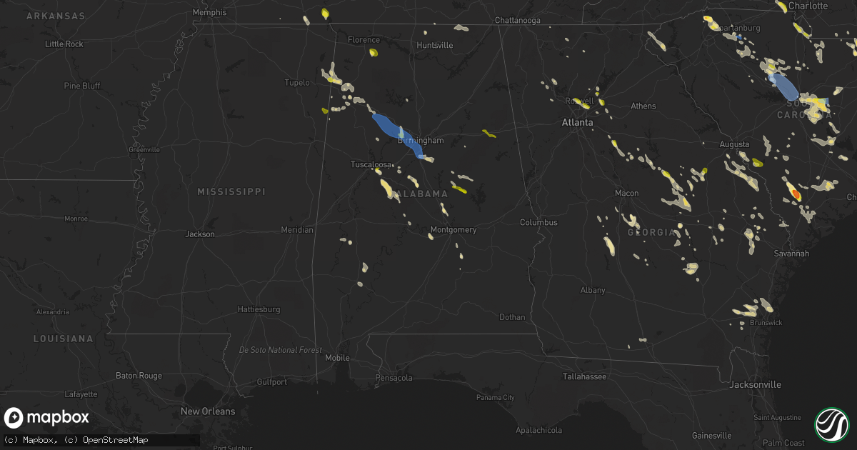
Hail Map in Alabama on June 17, 2022
Get this storm
June 17 map
$229
one time, instant access
Download today. No call, no setup
Keep the $229
Bought the map and want the full workflow? Apply the entire $229 to a subscription within 7 days. None of it is wasted.
Every map, not just this one
This buys you this map. Subscription and you get every map we run, in the markets you choose from a few cities to whole states to nationwide. Plus real-time alerts the moment a storm fires.
Contact data
Name, contact info, occupancy, even credit band for addresses in the footprint. You go from where it hit to who to call.
Become the source they trust
Unlimited branding weather history reports on demand. You already have the documented answer ready for the property owner, and you are the one who showed up with it.
Property data and RoofTrace estimates
Pull up any address you have got, its value and the exact code rules for that jurisdiction, straight from One Click Code. Then RoofTrace estimates the squares, pitch, and roof value, priced the way you price.
Storm reports in Alabama
Alabama
| Date | Description |
|---|---|
| 06/17/20226:45 PM CDT | A few trees were blown down in and around alexander city. |
| 06/17/20226:33 PM CDT | Emergency manager reports couple trees down along highway 84 near will road leading to lane blockage. |
| 06/17/20226:31 PM CDT | Multiple trees were blown down around deatsville. |
| 06/17/20226:28 PM CDT | Several trees and power lines were blown down. At least 8 roadways are completely blocked between marbury and white city. |
| 06/17/20225:49 PM CDT | Large tree limb fell onto a mobile home... Causing structural damage. Dime size hail also reported at the same location. Time estimated by radar. |
| 06/17/20225:17 PM CDT | Multiple trees were blown down around pondville. |
| 06/17/20224:56 PM CDT | A few large trees were snapped off near morgan road. |
| 06/17/20224:56 PM CDT | Large trees were blown down in the green valley area of hoover. |
| 06/17/20224:53 PM CDT | Skylights blown out of warehouse along i-459. |
| 06/17/20224:51 PM CDT | Several trees were blown down throughout helena including silver lakes... Highway 52... Highway 95... And highway 17. |
| 06/17/20224:46 PM CDT | Several trees were blown down... Several power poles snapped... And power lines down near east crest road and highschool road. |
| 06/17/20224:43 PM CDT | Large tree fell onto a home... Causing structural damage. Time estimated by radar. |
| 06/17/20224:43 PM CDT | Multiple trees were blown down on warrior river road. |
| 06/17/20224:38 PM CDT | Huge tree was blown down and blocking the roadway near the bessemer recreation center. |
| 06/17/20224:33 PM CDT | Multiple trees and power lines were blown down in and around west blocton. |
| 06/17/20224:14 PM CDT | Trees were blown down between parrish and copeland ferry. |
| 06/17/20224:12 PM CDT | Numerous trees were blown down in the southern part of walker county. |
| 06/17/20224:09 PM CDT | Large tree blown down near the high school. |
| 06/17/20224:07 PM CDT | Trees were blown down around hackleburg. |
| 06/17/20223:55 PM CDT | A few trees were blown down around oakman. |
| 06/17/20223:55 PM CDT | Trees and power lines were blown down on oakman parrish road. The downed power lines created a structure fire. No injuries were reported. |
| 06/17/20223:32 PM CDT | Trees down near the intersection of hwy 431 and hwy 204. |
| 06/17/20223:07 PM CDT | A few trees were blown down around guin. |
| 06/17/20222:42 PM CDT | Trees were blown down around hackleburg. |
| 06/17/20222:32 PM CDT | Several trees were blown down around hamilton. |
| 06/17/20222:20 PM CDT | Trees down on a vehicle on hwy 19. |
| 06/17/20222:20 PM CDT | A few trees down along hwy 11 in red bay. |
| 06/17/20222:17 PM CDT | Hail fell for several minutes and may have been larger. |
| 06/17/20222:09 PM CDT | Numerous trees were blown down around shottsville. |
| 06/17/20221:28 PM CDT | At least quarter size hail reported along hwy 157 south of leighton. |
| 06/17/20227:52 AM CDT | At 1252 AM CDT, a severe thunderstorm was located 7 miles northwest of Corinth, or 7 miles southwest of Heflin, moving west at 15 mph. HAZARD...60 mph wind gusts and quarter size hail. SOURCE...Radar indicated. IMPACT...Hail damage to vehicles is expected. Expect wind damage to roofs, siding, and trees. Locations impacted include... Anniston, Oxford, Heflin, Mount Cheaha, Dearmanville, Hollis Crossroads, Chalafinnee, Choccolocco and Camp Sequoyah. |
| 06/17/20227:07 AM CDT | At 1206 AM CDT, a severe thunderstorm was located over Highway 9 and Highway 22, or 7 miles south of Kellyton, moving northwest at 10 mph. HAZARD...60 mph wind gusts and quarter size hail. SOURCE...Radar indicated. IMPACT...Hail damage to vehicles is expected. Expect wind damage to roofs, siding, and trees. Locations impacted include... Rockford, Highway 9 and Highway 22, Cottage Grove, Nixburg, Crewsville, Western Lake Martin, Fishpond, Hissop and Ray. |
| 06/17/20222:38 AM CDT | At 737 PM CDT, a severe thunderstorm was located over Sprague, or 10 miles northwest of Meadville, moving southeast at 20 mph. HAZARD...60 mph wind gusts and quarter size hail. SOURCE...Radar indicated. IMPACT...Hail damage to vehicles is expected. Expect wind damage to roofs, siding, and trees. Locations impacted include... Meadville, Pine Level, Strata, Dublin, Naftel, Sprague, Grady, Sellers, Davenport, Ramer, Lapine, Pintlala and Currys. |
| 06/17/20222:13 AM CDT | At 713 PM CDT, a severe thunderstorm was located over Lowndesboro, or near Hayneville, moving southeast at 20 mph. HAZARD...60 mph wind gusts and quarter size hail. SOURCE...Radar indicated. IMPACT...Hail damage to vehicles is expected. Expect wind damage to roofs, siding, and trees. Locations impacted include... Fort Deposit, Mosses, Hayneville, White Hall, Gordonville, Lowndesboro, Beechwood, Strata, Logan, Sellers, Davenport, Lowndes County Airport, Calhoun and Letohatchee. |
| 06/17/20221:35 AM CDT | At 634 PM CDT, a severe thunderstorm was located near Burnsville, or near Selma, moving southeast at 20 mph. HAZARD...60 mph wind gusts and quarter size hail. SOURCE...Radar indicated. IMPACT...Hail damage to vehicles is expected. Expect wind damage to roofs, siding, and trees. Locations impacted include... Selma, Selmont-West Selmont, Memorial Stadium, Gardner Island, Burnsville, Tyler, Selma Drag Strip, Edmund Pettus Bridge, Selma University and Craig Field Aiport. |
| 06/17/20221:28 AM CDT | At 628 PM CDT, a severe thunderstorm was located over Whatley, or near Grove Hill, moving south at 10 mph. HAZARD...60 mph wind gusts and quarter size hail. SOURCE...Radar indicated. IMPACT...Hail damage to vehicles is expected. Expect wind damage to roofs, siding, and trees. Locations impacted include... Grove Hill and Whatley. |
| 06/17/20221:25 AM CDT | At 625 PM CDT, a severe thunderstorm was located near Deatsville, or 9 miles northwest of Millbrook, moving southeast at 20 mph. HAZARD...60 mph wind gusts and quarter size hail. SOURCE...Radar indicated. IMPACT...Hail damage to vehicles is expected. Expect wind damage to roofs, siding, and trees. Locations impacted include... Prattville, Millbrook, Wetumpka, Elmore, Coosada, Deatsville, Blue Ridge, Jordan Lake, Holtville, Wetumpka Municipal Airport and Speigner. |
| 06/17/20221:19 AM CDT | At 618 PM CDT, a severe thunderstorm was located over Bentleyville, or near Rockford, moving southeast at 15 mph. HAZARD...60 mph wind gusts and quarter size hail. SOURCE...Radar indicated. IMPACT...Hail damage to vehicles is expected. Expect wind damage to roofs, siding, and trees. Locations impacted include... Rockford, Equality, Hanover, Speed, Lyle, Pentonville, Cottage Grove, Bentleyville, Highway 9 and Highway 22, Nixburg, Crewsville, Western Lake Martin, Fishpond, Ray and Hissop. |
| 06/17/202212:52 AM CDT | At 551 PM CDT, a severe thunderstorm was located near Heiberger, or 11 miles northeast of Marion, moving southeast at 20 mph. HAZARD...60 mph wind gusts and quarter size hail. SOURCE...Radar indicated. IMPACT...Hail damage to vehicles is expected. Expect wind damage to roofs, siding, and trees. Locations impacted include... Heiberger, Sprott, Suttle, Oakmulgee, Ellards and Radford. |
| 06/17/202212:38 AM CDT | At 538 PM CDT, a severe thunderstorm was located 5 miles northeast of Fulton, or 6 miles southeast of Thomasville, moving southeast at 10 mph. HAZARD...60 mph wind gusts and quarter size hail. SOURCE...Radar indicated. IMPACT...Hail damage to vehicles is expected. Expect wind damage to roofs, siding, and trees. Locations impacted include... Whatley and Fulton. |
| 06/17/202212:34 AM CDT | At 533 PM CDT, a severe thunderstorm was located near Mertz, or 7 miles west of Brent, moving southeast at 10 mph. HAZARD...60 mph wind gusts and half dollar size hail. SOURCE...Radar indicated. IMPACT...Hail damage to vehicles is expected. Expect wind damage to roofs, siding, and trees. Locations impacted include... Heiberger and Ellards. |
| 06/17/202212:16 AM CDT | At 516 PM CDT, a severe thunderstorm was located over Low Gap, or 10 miles west of Brent, moving southeast at 25 mph. HAZARD...60 mph wind gusts and quarter size hail. SOURCE...Radar indicated. IMPACT...Hail damage to vehicles is expected. Expect wind damage to roofs, siding, and trees. Locations impacted include... Brent, Centreville, Eoline, Low Gap, Mertz, Harmon and Pearson. |
| 06/17/202212:12 AM CDT | At 512 PM CDT, a severe thunderstorm was located near Chilton County Motor Sports Park, or near Jemison, moving southeast at 30 mph. HAZARD...60 mph wind gusts and quarter size hail. SOURCE...Radar indicated. IMPACT...Hail damage to vehicles is expected. Expect wind damage to roofs, siding, and trees. Locations impacted include... Clanton, Jemison, Thorsby, Billingsley, Chilton County Motor Sports Park, Verbena, Pooles Crossroads, Lomax, Isabella, I 65 Rest Area and Cooper. |
| 06/16/202211:54 PM CDT | At 454 PM CDT, a severe thunderstorm was located near McFarland Mall, or near Tuscaloosa, moving southeast at 10 mph. HAZARD...60 mph wind gusts and half dollar size hail. SOURCE...Radar indicated. IMPACT...Hail damage to vehicles is expected. Expect wind damage to roofs, siding, and trees. Locations impacted include... Southeastern Tuscaloosa, Holt, Coaling, Lake Wildwood, McFarland Mall, Shelton State Community College, Englewood, Cottondale, Little Sandy, Camp Horne B.S.A., Maxwell, Peterson, Taylorville, Hagler, Duncanville and Pearson. |
| 06/16/202211:53 PM CDT | At 452 PM CDT, a severe thunderstorm was located over Ashby, or 7 miles southwest of Montevallo, moving southeast at 20 mph. HAZARD...60 mph wind gusts and quarter size hail. SOURCE...Radar indicated. IMPACT...Hail damage to vehicles is expected. Expect wind damage to roofs, siding, and trees. Locations impacted include... Montevallo, Wilton, Brierfield Ironworks Park, University Of Montevallo, Ashby and Six Mile. |
| 06/16/202211:45 PM CDT | At 444 PM CDT, a severe thunderstorm was located over Hoover Metropolitan Stadium, or near Helena, moving southeast at 30 mph. HAZARD...60 mph wind gusts and quarter size hail. SOURCE...Radar indicated. IMPACT...Hail damage to vehicles is expected. Expect wind damage to roofs, siding, and trees. Locations impacted include... Hoover, Alabaster, Pelham, Helena, Calera, Chelsea, Montevallo, Columbiana, Wilsonville, Indian Springs Village, American Village, Oak Mountain State Park, Maylene, Oak Mountain Amphitheater, Inverness, Highland Lakes, Riverchase, Shelby County Airport, Meadowbrook and Brook Highland. |
| 06/16/202211:22 PM CDT | At 421 PM CDT, a severe thunderstorm was located over North Bibb, or 14 miles north of Centreville, moving southeast at 10 mph. HAZARD...60 mph wind gusts and quarter size hail. SOURCE...Radar indicated. IMPACT...Hail damage to vehicles is expected. Expect wind damage to roofs, siding, and trees. Locations impacted include... Lake View, Coaling, Vance, Woodstock, West Blocton, Tannehill Ironworks State Park, Abernant, Mercedes Benz Of Alabama, North Bibb, Bucksville, Marvel, Green Pond, Caffee Junction and Hebron. |
| 06/16/202211:13 PM CDT | At 413 PM CDT, a severe thunderstorm was located 7 miles northeast of Bull City, or 13 miles northwest of Hueytown, moving southeast at 30 mph. HAZARD...60 mph wind gusts. SOURCE...Radar indicated. IMPACT...Expect damage to roofs, siding, and trees. Locations impacted include... Southwestern Birmingham, Hoover, Vestavia Hills, Bessemer, Homewood, Mountain Brook, Hueytown, Fairfield, Pleasant Grove, Midfield, Adamsville, Brighton, Lipscomb, Graysville, Lake View, Sylvan Springs, Mulga, Maytown, West Jefferson and North Johns. |
| 06/16/202211:01 PM CDT | At 401 PM CDT, a severe thunderstorm was located over Myrtlewood, or 10 miles southwest of Linden, moving southeast at 10 mph. HAZARD...60 mph wind gusts and quarter size hail. SOURCE...Radar indicated. IMPACT...Hail damage to vehicles is expected. Expect wind damage to roofs, siding, and trees. Locations impacted include... Sweet Water, Myrtlewood, Miller, Nanafalia, Calvary, Half Acre and Octagon. |
| 06/16/202210:47 PM CDT | At 346 PM CDT, severe thunderstorms were located along a line extending from 7 miles east of Carbon Hill to 7 miles northeast of Berry to near Bankston, moving southeast at 45 mph. HAZARD...60 mph wind gusts. SOURCE...Radar indicated. IMPACT...Expect damage to roofs, siding, and trees. Locations impacted include... Jasper, Fayette, Sumiton, Cordova, Dora, Carbon Hill, Berry, Parrish, Oakman, Kansas, Bankston, Gorgas Steam Plant, Samantha, Gorgas, Boley Springs, Burnwell, Beloit, Binion Creek Landing, Stone Wall and Whitson. |
| 06/16/202210:02 PM CDT | At 301 PM CDT, severe thunderstorms were located along a line extending from near Lake Buttahatchee to Gu-Win to near Vernon, moving southeast at 20 mph. HAZARD...60 mph wind gusts and half dollar size hail. SOURCE...Radar indicated. IMPACT...Hail damage to vehicles is expected. Expect wind damage to roofs, siding, and trees. Locations impacted include... Winfield, Fayette, Carbon Hill, Guin, Berry, Brilliant, Glen Allen, Kansas, Nauvoo, Belk, Gu- Win, Eldridge, Bankston, Bluff, Ashcraft Corner, Boley Springs, Twin, Tucker, Stone Wall and Wayside. |
| 06/16/20229:29 PM CDT | At 228 PM CDT, a severe thunderstorm was located near Weston, or near Hamilton, moving southeast at 20 mph. HAZARD...Ping pong ball size hail and 60 mph wind gusts. SOURCE...Radar indicated. IMPACT...People and animals outdoors will be injured. Expect hail damage to roofs, siding, windows, and vehicles. Expect wind damage to roofs, siding, and trees. Locations impacted include... Hamilton, Winfield, Haleyville, Guin, Hackleburg, Brilliant, Glen Allen, Brinn, Weston, Lake Buttahatchee, Bear Creek, Twin, Tucker, Tessner, Shottsville, Pearces Mill, Rankin Fite Airport, Byrd, Texas and Bexar. |
| 06/16/20228:52 PM CDT | At 151 PM CDT, a severe thunderstorm was located near Tremont, or 11 miles south of Red Bay, moving southeast at 15 mph. HAZARD...Golf ball size hail and 60 mph wind gusts. SOURCE...Radar indicated. IMPACT...People and animals outdoors will be injured. Expect hail damage to roofs, siding, windows, and vehicles. Expect wind damage to roofs, siding, and trees. Locations impacted include... Hamilton, Weston, Shottsville, Rankin Fite Airport, Byrd and Bexar. |
| 06/16/20228:46 PM CDT | At 146 AM CDT, a severe thunderstorm was located near Honda Manufacturing Of Alabama, or 11 miles west of West End-Cobb Town, moving northwest at 15 mph. HAZARD...60 mph wind gusts and half dollar size hail. SOURCE...Radar indicated. IMPACT...Hail damage to vehicles is expected. Expect wind damage to roofs, siding, and trees. Locations impacted include... Talladega, Pell City, Lincoln, Riverside, Ragland, Ohatchee, Logan Martin Lake, Talladega Superspeedway, Honda Manufacturing Of Alabama, Talladega Municipal Airport, Neely Henry Lake, Anniston Army Depot, St. Clair County Airport, Wattsville, Neely Henry Dam, Eastaboga, Jackson Shoals and Howells Cove. |
| 06/16/20228:38 PM CDT | At 137 PM CDT, a severe thunderstorm was located 10 miles west of Moulton, moving southeast at 20 mph. HAZARD...60 mph wind gusts and half dollar size hail. SOURCE...Radar indicated. IMPACT...Hail damage to vehicles is expected. Expect wind damage to roofs, siding, and trees. Locations impacted include... Moulton, Littleville, Newburg, Hatton, Mt Hope, La Grange, Tharptown, Ne Smith, Whiteoak and Landersville. |
| 06/16/20228:35 PM CDT | At 134 PM CDT, a severe thunderstorm was located over Fairview, or 9 miles southwest of Red Bay, moving south at 10 mph. HAZARD...Quarter size hail. SOURCE...Radar indicated. IMPACT...Damage to vehicles is expected. Locations impacted include... Tremont, Fairview, Clay, Eastman and Bounds Crossroads. |
| 06/16/20228:25 PM CDT | At 125 AM CDT, a severe thunderstorm was located over Oxford Lake, or over Oxford, moving west at 15 mph. HAZARD...60 mph wind gusts and quarter size hail. SOURCE...Radar indicated. IMPACT...Hail damage to vehicles is expected. Expect wind damage to roofs, siding, and trees. Locations impacted include... Anniston, Oxford, Saks, Cobb Town, West End-Cobb Town, Munford, Hobson City, Grant Town, Anniston Regional Airport, Oxford Lake, Blue Mountain, Bynum, Alexandria, Anniston Army Depot, Dearmanville and Jenifer. |
| 06/16/20228:11 PM CDT | At 111 PM CDT, a severe thunderstorm was located near Leighton, or 10 miles southeast of Muscle Shoals, moving southeast at 20 mph. HAZARD...60 mph wind gusts and quarter size hail. SOURCE...Radar indicated. IMPACT...Hail damage to vehicles is expected. Expect wind damage to roofs, siding, and trees. Locations impacted include... Moulton, Littleville, Leighton, Newburg, Hatton, Mt Hope, La Grange, Tharptown, Ne Smith and Whiteoak. |
All States Impacted by Hail Map on June 17, 2022
Cities Impacted by Hail Map on June 17, 2022
- Eureka, MT
- Georgetown, KY
- Kalispell, MT
- Condon, MT
- Spencer, WV
- East Setauket, NY
- Island Falls, ME
- Smyrna Mills, ME
- Oakfield, ME
- Newcastle, WY
- Sweet Grass, MT
- Cut Bank, MT
- Hill City, SD
- Blue Creek, OH
- Stout, OH
- Elkview, WV
- Charleston, WV
- Kenna, WV
- Deadwood, SD
- Lead, SD
- Advent, WV
- Ripley, WV
- Walton, WV
- Gandeeville, WV
- Dandridge, TN
- Jefferson City, TN
- Evansville, IN
- Newburgh, IN
- Bardstown, KY
- Cadiz, KY
- Frankfort, KY
- Valier, MT
- Browning, MT
- Heart Butte, MT
- Liberty, WV
- Red House, WV
- Leon, WV
- Buffalo, WV
- Poca, WV
- Port Jefferson, NY
- Port Jefferson Station, NY
- Mount Sinai, NY
- Mount Zion, WV
- Vine Grove, KY
- Custer, KY
- Irvington, KY
- Cecilia, KY
- Guston, KY
- Rineyville, KY
- Mechanicsville, VA
- Hanover, VA
- Ashland, VA
- Hartfield, VA
- Davin, WV
- Acton, ME
- Lebanon, ME
- Hillsboro, KY
- Morehead, KY
- Foster, KY
- Augusta, KY
- Brooksville, KY
- Mount Lookout, WV
- Southside, WV
- Henderson, WV
- Lavalette, WV
- Owensboro, KY
- Utica, KY
- Nashville, NC
- Blackwater, VA
- Kyles Ford, TN
- Powellton, WV
- Kimberly, WV
- Wayne, WV
- Prichard, WV
- Louisa, KY
- Catlettsburg, KY
- Rush, KY
- Boonville, IN
- Skippers, VA
- Emporia, VA
- Luttrell, TN
- Powder Springs, TN
- Newsoms, VA
- Courtland, VA
- Whaleyville, MD
- Frankford, DE
- Berlin, MD
- Willards, MD
- Delmar, MD
- Showell, MD
- Delmar, DE
- Millsboro, DE
- Laurel, DE
- Bishopville, MD
- Ocean City, MD
- Parsonsburg, MD
- Pittsville, MD
- Fayetteville, TN
- Guin, AL
- Hamilton, AL
- Brilliant, AL
- Suwanee, GA
- Buford, GA
- Lancaster, SC
- Bennettsville, SC
- Wallace, SC
- McColl, SC
- Hamlet, NC
- East Point, KY
- Cerulean, KY
- Gracey, KY
- Hopkinsville, KY
- Diagonal, IA
- Lenox, IA
- Clearfield, IA
- Madisonville, KY
- Dawson Springs, KY
- Nebo, KY
- Hermitage, TN
- Watertown, TN
- Murfreesboro, TN
- Madison, TN
- La Vergne, TN
- Nashville, TN
- Brentwood, TN
- Lebanon, TN
- Smyrna, TN
- Old Hickory, TN
- Whites Creek, TN
- Antioch, TN
- Mount Juliet, TN
- Linton, IN
- Switz City, IN
- Lyons, IN
- New Durham, NH
- Vesuvius, VA
- Buena Vista, VA
- Lexington, VA
- Fairfield, VA
- Natural Bridge, VA
- Hurricane, WV
- Winfield, WV
- Lexington, KY
- Paris, KY
- Sadieville, KY
- Corinth, KY
- Julian, WV
- Foster, WV
- Ridgeview, WV
- Sheridan, WY
- Saluda, VA
- Locust Hill, VA
- Salt Lick, KY
- Patoka, IN
- Hazleton, IN
- Rogersville, TN
- Marion, KY
- Fredonia, KY
- Hurley, VA
- Fort Gay, WV
- Webbville, KY
- Hacker Valley, WV
- Centertown, KY
- Central City, KY
- Yale, VA
- White Plains, KY
- Elkton, KY
- Drakesboro, KY
- Greenville, KY
- Lewisburg, KY
- Sharon Grove, KY
- Crofton, KY
- Dunmor, KY
- Nortonville, KY
- Beech Creek, KY
- Belton, KY
- Russellville, KY
- Flemingsburg, KY
- Raphine, VA
- Pinewood, SC
- Summerton, SC
- Georgetown, DE
- Reed, KY
- Alkol, WV
- Monroe, VA
- Glasgow, VA
- Easton, ME
- Presque Isle, ME
- Shelbyville, KY
- Tomahawk, KY
- Natural Bridge Station, VA
- Wallingford, KY
- Evans, WV
- Given, WV
- Cottageville, WV
- Shelburn, IN
- Sullivan, IN
- Greensburg, KY
- Summersville, KY
- Hillsborough, NC
- Grand Chain, IL
- Sandy Hook, KY
- Elkfork, KY
- Blountville, TN
- Vest, KY
- Jackson, KY
- Hueysville, KY
- Spartanburg, SC
- Pauline, SC
- Lizemores, WV
- Sturgis, KY
- Cave In Rock, IL
- Shawneetown, IL
- Junction, IL
- Elizabethtown, IL
- Patriot, OH
- Gallipolis, OH
- Jarratt, VA
- Drewryville, VA
- Boykins, VA
- Capron, VA
- Providence, KY
- Salem, KY
- Clay, KY
- Livermore, KY
- Slaughters, KY
- Rumsey, KY
- Bremen, KY
- Dixon, KY
- Hanson, KY
- Island, KY
- Calhoun, KY
- Manitou, KY
- Sacramento, KY
- Battleboro, NC
- Castalia, NC
- Strawberry Plains, TN
- Tremont, MS
- Fulton, MS
- Golden, MS
- Vina, AL
- Red Bay, AL
- Scotland Neck, NC
- Halifax, NC
- Enfield, NC
- Salem, IN
- Sneedville, TN
- Thorn Hill, TN
- Sunburst, MT
- Newberry, SC
- Johnson City, TN
- Henderson, NC
- Essex, MT
- Portsmouth, OH
- Wheelersburg, OH
- Franklin Furnace, OH
- Ripley, OH
- South Charleston, WV
- Ireland, WV
- Harts, WV
- Princeton, KY
- Detroit, AL
- Madisonville, TN
- Norwich, CT
- Bozrah, CT
- Minford, OH
- Milton, NH
- Union, NH
- Equality, IL
- Gallipolis Ferry, WV
- Dover, KY
- South Portsmouth, KY
- South Shore, KY
- Falmouth, KY
- Princeton, IN
- Columbia Falls, MT
- Louisa, VA
- Cape May, NJ
- Wildwood, NJ
- Lynx, OH
- Chapmanville, WV
- Big Creek, WV
- Albion, IL
- West Salem, IL
- Dugger, IN
- Midway, KY
- Stamping Ground, KY
- Crane, IN
- Odon, IN
- Loogootee, IN
- Elnora, IN
- Stem, NC
- Olmsted, IL
- Ullin, IL
- Pulaski, IL
- Villa Ridge, IL
- Dongola, IL
- Delbarton, WV
- Sarah Ann, WV
- Gilbert, WV
- Omar, WV
- Helvetia, WV
- Pickens, WV
- Buffalo, KY
- Sonora, KY
- Magnolia, KY
- Upton, KY
- Hodgenville, KY
- Mount Sherman, KY
- Knoxville, TN
- Whitesville, KY
- Hartford, KY
- Ranger, WV
- Branchland, WV
- Mosheim, TN
- Waynesburg, KY
- Eubank, KY
- Amherstdale, WV
- Man, WV
- Summersville, WV
- Dixie, WV
- Victor, WV
- Drennen, WV
- Belva, WV
- Swiss, WV
- Ansted, WV
- Coxs Creek, KY
- Bloomfield, KY
- Clearmont, WY
- Buffalo, WY
- Decker, MT
- Birney, MT
- Stony Creek, VA
- Rocky Mount, NC
- Chapel Hill, NC
- Liberty Hill, SC
- Patrick, SC
- Society Hill, SC
- Cheraw, SC
- Morven, NC
- Chesterfield, SC
- Garland, NC
- Rural Hall, NC
- Pfafftown, NC
- Winston Salem, NC
- Newport, TN
- Bybee, TN
- Parrottsville, TN
- Creal Springs, IL
- New Burnside, IL
- Stonefort, IL
- Lawrenceville, GA
- Grayson, GA
- Loganville, GA
- Leighton, AL
- Wilson, NC
- Elm City, NC
- Midway, TN
- Beaverton, AL
- Clio, SC
- Metter, GA
- Twin City, GA
- Cobbtown, GA
- Cape Girardeau, MO
- McClure, IL
- Franklinton, NC
- Statesboro, GA
- Kodak, TN
- Vance, AL
- Union, SC
- Brent, AL
- Marion, AL
- Norway, SC
- Hartsville, SC
- Ledbetter, KY
- Kuttawa, KY
- Grand Rivers, KY
- Smithland, KY
- Bessemer City, NC
- Clover, SC
- Gastonia, NC
- Kings Mountain, NC
- Kingston, GA
- Brooklet, GA
- Fort Branch, IN
- Francisco, IN
- Round O, SC
- Cottageville, SC
- Ruffin, SC
- Walterboro, SC
- Sylacauga, AL
- Monticello, GA
- Parkton, NC
- Lumber Bridge, NC
- Saint Pauls, NC
- Raeford, NC
- Madison, GA
- Eatonton, GA
- Crisfield, MD
- Hallwood, VA
- Yemassee, SC
- Red Springs, NC
- Maxton, NC
- Evensville, TN
- Decatur, TN
- Oxford, MS
- Cameron, SC
- Saint Matthews, SC
- Harrison, GA
- Davisboro, GA
- Sandersville, GA
- Bartow, GA
- Columbiana, AL
- Chelsea, AL
- Helena, AL
- Pelham, AL
- Shaw, MS
- Boyle, MS
- Arp, TX
- Tyler, TX
- Eustace, TX
- Canton, TX
- Brunswick, GA
- Hortense, GA
- Waynesville, GA
- Talladega, AL
- Mitchell, GA
- Rock Island, TN
- Whatley, AL
- Grove Hill, AL
- Savannah, TN
- Gibson, GA
- Stryker, MT
- Cross, SC
- Holly Hill, SC
- Tellico Plains, TN
- Singer, LA
- Bonaire, GA
- Orangeburg, SC
- Santee, SC
- Elloree, SC
- Islandton, SC
- Moravian Falls, NC
- Wilkesboro, NC
- Orange, VA
- Vonore, TN
- Anna, IL
- Jonesboro, IL
- Havelock, NC
- Union Grove, NC
- Statesville, NC
- Paducah, KY
- West Paducah, KY
- Heath Springs, SC
- Atlanta, GA
- Peachtree Corners, GA
- Norcross, GA
- Moore, SC
- Dequincy, LA
- Niota, TN
- Athens, TN
- Sparta, GA
- Varnville, SC
- Hampton, SC
- Grady, AL
- Ramer, AL
- Pomaria, SC
- Whitmire, SC
- Brunson, SC
- Early Branch, SC
- Sulligent, AL
- Deatsville, AL
- Hackleburg, AL
- Andrews, SC
- McKenney, VA
- Morganfield, KY
- Meherrin, VA
- Victoria, VA
- Green Bay, VA
- Darlington, SC
- Nettleton, MS
- Rockingham, NC
- Ellerbe, NC
- Fort Mill, SC
- Waxhaw, NC
- Winnsboro, SC
- Great Falls, SC
- Peachland, NC
- Pembroke, NC
- Lumberton, NC
- Kershaw, SC
- Engelhard, NC
- Taylors, SC
- Greer, SC
- Randolph, AL
- Jemison, AL
- Dry Branch, GA
- Kathleen, GA
- Travelers Rest, SC
- Roswell, GA
- Marietta, GA
- Rockwell, NC
- Salisbury, NC
- Gold Hill, NC
- Lexington, NC
- Clemmons, NC
- Counce, TN
- Mantachie, MS
- Saltillo, MS
- Guntown, MS
- Ridge, MD
- Dameron, MD
- Scotland, MD
- Piney Point, MD
- Saint Inigoes, MD
- Temperanceville, VA
- Parksley, VA
- Mears, VA
- Bloxom, VA
- Sanford, VA
- Greenbush, VA
- Ellijay, GA
- Magnolia, NC
- Rose Hill, NC
- Crandall, GA
- Vanceboro, NC
- New Market, TN
- Cartersville, GA
- Blenheim, SC
- Berry, AL
- Columbus, MS
- Soperton, GA
- Sweetwater, TN
- Englewood, TN
- Walnut, MS
- Weogufka, AL
- Jacksonville, TX
- North Charleston, SC
- Charleston, SC
- Thomson, GA
- Blackville, SC
- Barnwell, SC
- Williston, SC
- Neeses, SC
- Frankston, TX
- Glenwood, GA
- Leland, MS
- Tuscaloosa, AL
- Sylvania, GA
- Waynesboro, GA
- Sardis, GA
- Blythe, GA
- Keysville, GA
- Hephzibah, GA
- Girard, GA
- Byron, GA
- Montezuma, GA
- Wrightsville, GA
- Selma, AL
- Sumter, SC
- Vernon, AL
- Dingess, WV
- Linden, AL
- Pennington, AL
- Sweet Water, AL
- Georgetown, SC
- Brierfield, AL
- Montevallo, AL
- Marbury, AL
- Elmore, AL
- Prattville, AL
- Pembroke, GA
- Fort Stewart, GA
- Ruther Glen, VA
- Doswell, VA
- Beaverdam, VA
- Natchez, MS
- Thomasville, AL
- Pine Hill, AL
- Rock Hill, SC
- Duncanville, AL
- Cottondale, AL
- Hazlehurst, GA
- Jackson, SC
- Tennille, GA
- Pinehurst, GA
- Byromville, GA
- Vienna, GA
- Covington, GA
- Mansfield, GA
- Buncombe, IL
- Bluff City, TN
- Elizabethton, TN
- Dalzell, SC
- Dublin, GA
- Quinton, AL
- Mulga, AL
- West Point, MS
- Hoffman, NC
- Marston, NC
- Birmingham, AL
- Troup, TX
- Ridgeville, SC
- Lane, SC
- Athens, TX
- Mount Sterling, KY
- Gattman, MS
- Caledonia, MS
- Patterson, GA
- Nahunta, GA
- Wolf Lake, IL
- Partridge, KY
- Wise, VA
- Eolia, KY
- Appalachia, VA
- Norton, VA
- Philpot, KY
- Estillfork, AL
- Scottsboro, AL
- Gatesville, NC
- Gates, NC
- Eure, NC
- Pollocksville, NC
- Pegram, TN
- Saint Charles, KY
- Dayton, TN
- Spring Hope, NC
- Powell, TN
- Arapahoe, NC
- Grantsboro, NC
- New Bern, NC
- Metropolis, IL
- Rosiclare, IL
- Cypress, IL
- Grantsburg, IL
- Simpson, IL
- Hampton, KY
- Vienna, IL
- Karnak, IL
- Belknap, IL
- Brookport, IL
- Golconda, IL
- Goreville, IL
- Jonesborough, TN
- Clarkson, KY
- Rydal, GA
- White, GA
- Advance, NC
- Enoree, SC
- Clinton, NC
- Alamo, GA
- McRae Helena, GA
- Greensboro, NC
- Whitsett, NC
- Winfield, AL
- Maryville, TN
- Walland, TN
- Burlington, NC
- Browns Summit, NC
- Reidsville, NC
- Gibsonville, NC
- Elon, NC
- Goose Creek, SC
- Lithonia, GA
- Carbon Hill, AL
- Nauvoo, AL
- Eldridge, AL
- Townley, AL
- Abbeville, GA
- Maysville, NC
- Toney, AL
- Harvest, AL
- Acworth, GA
- Dallas, GA
- Aiken, SC
- Kingstree, SC
- Kellyton, AL
- Goodwater, AL
- Mount Pleasant, SC
- Milledgeville, GA
- Windsor, SC
- Clyo, GA
- Olar, SC
- Fairfax, SC
- Ulmer, SC
- Warthen, GA
- Luverne, AL
- Stamps, AR
- Duncan, MS
- Reynolds, GA
- Nacogdoches, TX
- Darien, GA
- Townsend, GA
- Quitman, GA
- Bokeelia, FL
- Shady Valley, TN
- Mountain City, TN
- Avera, GA
- Stapleton, GA
- Louisville, GA
- Blaine, TN
- Mascot, TN
- Ramer, TN
- Somerset, KY
- Jackson, MO
- Burfordville, MO
- Hopkins, SC
- Wedgefield, SC
- Columbia, KY
- Bristol, TN
- High Point, NC
- Jamestown, NC
- Colfax, NC
- Kernersville, NC
- Hiddenite, NC
- Harmony, NC
- Cleveland, NC
- Olin, NC
- Laurel Bloomery, TN
- Cedar Grove, NC
- Mebane, NC
- Roxboro, NC
- Prospect Hill, NC
- Timberlake, NC
- Hurdle Mills, NC
- Delphia, KY
- Linefork, KY
- Whitesburg, KY
- Cumberland, KY
- Hallie, KY
- Clayton, GA
- Walhalla, SC
- Mountain Rest, SC
- Westminster, SC
- Seneca, SC
- Monroe, NC
- Wingate, NC
- Marshville, NC
- Cumming, GA
- Woodstock, AL
- Merryville, LA
- Bishopville, SC
- Camden, SC
- Rembert, SC
- Glendale, KY
- Boston, KY
- New Haven, KY
- Elizabethtown, KY
- Beulaville, NC
- Pink Hill, NC
- Kenansville, NC
- Richlands, NC
- Clifton Forge, VA
- Eagle Rock, VA
- Edmonton, KY
- Bonnieville, KY
- Cobbs Creek, VA
- Morristown, TN
- White Pine, TN
- Oak Ridge, MO
- Seabrook, SC
- Beaufort, SC
- Coosawhatchie, SC
- Sheldon, SC
- Ridgeland, SC
- Crandall, TX
- Greenville, SC
- Landrum, SC
- Conway, SC
- Buffalo, SC
- Jonesville, SC
- Lyons, GA
- Cobden, IL
- Eastview, KY
- Montgomery, AL
- Marshallville, GA
- Fort Valley, GA
- Tar Heel, NC
- Bladenboro, NC
- Cochran, GA
- Warner Robins, GA
- Perry, GA
- Hawkinsville, GA
- Denmark, SC
- Cordele, GA
- Lambert, MS
- Lugoff, SC
- Columbia, SC
- Eastover, SC
- Elgin, SC
- Gadsden, SC
- Blair, SC
- Pinetops, NC
- Fountain, NC
- Macclesfield, NC
- Lumber City, GA
- Talking Rock, GA
- Spencer, NC
- Bumpass, VA
- Partlow, VA
- Spotsylvania, VA
- Tiplersville, MS
- West Blocton, AL
- White Oak, NC
- Swainsboro, GA
- East Dublin, GA
- Duncan, SC
- Woodruff, SC
- Roebuck, SC
- Lowndesboro, AL
- Kingsport, TN
- Ruby, SC
- Jeffersonville, KY
- Richland, IN
- Elberfeld, IN
- Oakland City, IN
- Waterloo, OH
- Bristol, VA
- Garysburg, NC
- Jackson, NC
- Roanoke Rapids, NC
- Weldon, NC
- Middleton, TN
- Catawba, SC
- Lilburn, GA
- Prosperity, SC
- North, SC
- Seagoville, TX
- Starkville, MS
- Estill, SC
- White Oak, GA
- Waverly, GA
- London, KY
- Salyersville, KY
- East Glacier Park, MT
- Lansing, NC
- Campbellsville, KY
- Graham, KY
- Keavy, KY
- Ferguson, KY
- Rutledge, TN
- Talbott, TN
- Unionville, VA
- Aylett, VA
- Mineral, VA
- Manquin, VA
- Inez, KY
- Mcminnville, TN
- Smithville, TN
- Kermit, WV
- Lenore, WV
- Breeden, WV
- Holden, WV
- Logan, WV
- Chapin, SC
- Little Mountain, SC
- Todd, NC
- Zionville, NC
- Creston, NC
- Apex, NC
- Durham, NC
- Cary, NC
- Creedmoor, NC
- Oxford, NC
- Damascus, VA
- Clinton, SC
- Fairmont, NC
- Liberty, TN
- Greenwood Springs, MS
- Amory, MS
- Hamilton, MS
- Mount Croghan, SC
- Rougemont, NC
- Mount Vernon, GA
- Corinth, MS
- Guys, TN
- Blackstock, SC
- Carlisle, SC
- Benoit, MS
- Pageland, SC
- Mantee, MS
- Rochelle, GA
- Tarboro, NC
- Swanquarter, NC
- Newington, GA
- Crane Hill, AL
- Bremen, AL
- Pineland, SC
- Garfield, GA
- Barnardsville, NC
- Latta, SC
- Springfield, GA
- Eutawville, SC
- Moncks Corner, SC
- Bonneau, SC
- Rockledge, GA
- Lewisville, AR
- Collins, GA
- Dermott, AR
- Toomsboro, GA
- Valdosta, GA
- Hahira, GA
- Big Clifty, KY
- Leitchfield, KY
- Earlington, KY
- Corryton, TN
- Tamms, IL
- Monticello, KY
- Iuka, MS
- Woodleaf, NC
- Cooleemee, NC
- Jasper, TX
- Westfield, ME
- Polebridge, MT
- Iron Gate, VA
- West Columbia, SC
- Blythewood, SC
- Jenkinsville, SC
- Irmo, SC
- Shaw Afb, SC
- Walling, TN
- Shiloh, TN
- Alpharetta, GA
- Town Creek, AL
- Tuscumbia, AL
- Bessemer, AL
- Garner, NC
- Fuquay Varina, NC
- Butner, NC
- Morrisville, NC
- Youngsville, NC
- Bahama, NC
- Raleigh, NC
- Wake Forest, NC
- Leopold, IN
- Bone Gap, IL
- Chrisney, IN
- Stendal, IN
- Mount Carmel, IL
- Grayville, IL
- Evanston, IN
- Winslow, IN
- Browns, IL
- Spurgeon, IN
- Saint Anthony, IN
- Jasper, IN
- Lawrenceville, IL
- Ferdinand, IN
- Griffin, IN
- Velpen, IN
- Vincennes, IN
- Lynnville, IN
- Saint Meinrad, IN
- Saint Croix, IN
- Tell City, IN
- Troy, IN
- Petersburg, IN
- Bridgeport, IL
- Chandler, IN
- Birdseye, IN
- Haubstadt, IN
- Hawesville, KY
- Santa Claus, IN
- Bristow, IN
- Decker, IN
- Cynthiana, IN
- Holland, IN
- Poseyville, IN
- Saint Francisville, IL
- Branchville, IN
- Grandview, IN
- Dale, IN
- Lincoln City, IN
- Claremont, IL
- Dundas, IL
- Gentryville, IN
- Allendale, IL
- Parkersburg, IL
- Huntingburg, IN
- Bellmont, IL
- Calhoun, IL
- Sumner, IL
- Owensville, IN
- Otwell, IN
- Lamar, IN
- Tennyson, IN
- Lewisport, KY
- Olney, IL
- Rockport, IN
- Hardinsburg, IN
- Cannelburg, IN
- English, IN
- Washington, IN
- Orleans, IN
- Campbellsburg, IN
- French Lick, IN
- West Baden Springs, IN
- Montgomery, IN
- Milltown, IN
- Dubois, IN
- Paoli, IN
- Shoals, IN
- Marengo, IN
- Fredericksburg, IN
- Eddyville, IL
- Guthrie, KY
- Trenton, KY
- Eddyville, KY
- Sebree, KY
- Mortons Gap, KY
- Allensville, KY
- Burna, KY
- Morgantown, KY
- Adams, TN
- Clarksville, TN
- Oak Grove, KY
- Olmstead, KY
- Pembroke, KY
- Adairville, KY
- Auburn, KY
- Henlawson, WV
- Olympia, KY
- War, WV
- Verner, WV
- Banner, KY
- Grethel, KY
- South Williamson, KY
- Willis, VA
- Whitewood, VA
- Weeksbury, KY
- Eggleston, VA
- Bluefield, VA
- Leburn, KY
- Debord, KY
- Elkhorn City, KY
- Freeman, WV
- Iaeger, WV
- Versailles, KY
- Austinville, VA
- Parrott, VA
- Baisden, WV
- Harold, KY
- Belspring, VA
- Stollings, WV
- Staffordsville, KY
- Check, VA
- Pippa Passes, KY
- Lick Creek, KY
- Raven, VA
- Mousie, KY
- Brenton, WV
- Kyle, WV
- Staffordsville, VA
- Gunlock, KY
- Stanton, KY
- Rock, WV
- Hindman, KY
- Denniston, KY
- West Van Lear, KY
- Vansant, VA
- Deane, KY
- Canada, KY
- Hellier, KY
- Teaberry, KY
- Yolyn, WV
- Pembroke, VA
- Raven, KY
- Mallie, KY
- Betsy Layne, KY
- Auxier, KY
- Richlands, VA
- Floyd, VA
- Jesse, WV
- Langley, KY
- David, KY
- McAndrews, KY
- Newport, VA
- Winchester, KY
- Raysal, WV
- Varney, KY
- Lovely, KY
- Wheelwright, KY
- Wayland, KY
- Simon, WV
- Ashcamp, KY
- Forest Hills, KY
- Topmost, KY
- Phelps, KY
- Bramwell, WV
- Clear Fork, WV
- Royalton, KY
- Paynesville, WV
- Davy, WV
- Mize, KY
- McDowell, KY
- Bevinsville, KY
- Williamson, WV
- Maybeury, WV
- Draper, VA
- Breaks, VA
- Bypro, KY
- Elkhorn, WV
- Camp Creek, WV
- Nora, VA
- Neon, KY
- Fanrock, WV
- Hazel Green, KY
- Shelby Gap, KY
- Beaver, KY
- Dana, KY
- Jolo, WV
- Stopover, KY
- Cannel City, KY
- Belfry, KY
- Means, KY
- Rowe, VA
- Oceana, WV
- Switzer, WV
- Barren Springs, VA
- Steele, KY
- Robinson Creek, KY
- Wilsondale, WV
- Clinchco, VA
- Ransom, KY
- Haysi, VA
- Martin, KY
- Princeton, WV
- Regina, KY
- Grundy, VA
- Raccoon, KY
- Tram, KY
- Indian Valley, VA
- Jewell Ridge, VA
- Kegley, WV
- Pinsonfork, KY
- Copper Hill, VA
- Dema, KY
- Hagerhill, KY
- Fedscreek, KY
- Hardy, KY
- Beeson, WV
- Ivel, KY
- Chauncey, WV
- Pikeville, KY
- Pound, VA
- Ripplemead, VA
- Lackey, KY
- Mouthcard, KY
- Matheny, WV
- Eastern, KY
- Max Meadows, VA
- Salem, VA
- Elliston, VA
- Spanishburg, WV
- Dugspur, VA
- Swords Creek, VA
- Kimper, KY
- Clayhole, KY
- Glen Lyn, VA
- Crum, WV
- Herndon, WV
- Blacksburg, VA
- Minnie, KY
- Owingsville, KY
- Huddy, KY
- Oakwood, VA
- Hope, KY
- Switchback, WV
- Oil Springs, KY
- Glen Fork, WV
- Phyllis, KY
- Wellington, KY
- Ezel, KY
- Vancleve, KY
- Matewan, WV
- Kite, KY
- Riner, VA
- Big Rock, VA
- Wytheville, VA
- Melvin, KY
- Berwind, WV
- Lake, WV
- Bays, KY
- Davenport, VA
- Panther, WV
- Pocahontas, VA
- Tazewell, VA
- Radford, VA
- Narrows, VA
- McCarr, KY
- New Richmond, WV
- Jackhorn, KY
- Saulsville, WV
- Hiwassee, VA
- Bland, VA
- Pilot, VA
- Garrett, KY
- North Spring, WV
- Pilgrim, KY
- Shelbiana, KY
- Dunlow, WV
- Dwale, KY
- Bent Mountain, VA
- Stanville, KY
- Fancy Gap, VA
- Squire, WV
- Beauty, KY
- Pineville, WV
- North Tazewell, VA
- Shawsville, VA
- Peterstown, WV
- Elbert, WV
- Garner, KY
- Rousseau, KY
- Pilgrims Knob, VA
- Pecks Mill, WV
- Drift, KY
- Campton, KY
- Lyburn, WV
- Bandy, VA
- McRoberts, KY
- Virgie, KY
- Belcher, KY
- Stone, KY
- Honaker, VA
- Cleveland, VA
- Ikes Fork, WV
- Thelma, KY
- Clay City, KY
- Kimball, WV
- Frenchburg, KY
- Birchleaf, VA
- Montcalm, WV
- McClure, VA
- Mallory, WV
- West Liberty, KY
- Meally, KY
- Boons Camp, KY
- Rich Creek, VA
- Bastian, VA
- Mohawk, WV
- Ceres, VA
- Pine Top, KY
- Northfork, WV
- Sidney, KY
- Hillsville, VA
- Bim, WV
- Pearisburg, VA
- Athens, WV
- Dublin, VA
- Slade, KY
- Paintsville, KY
- Welch, WV
- Coeburn, VA
- Dante, VA
- Pulaski, VA
- Van Lear, KY
- Prestonsburg, KY
- Coal Mountain, WV
- Clintwood, VA
- Wharncliffe, WV
- Printer, KY
- Bee, VA
- Bluefield, WV
- Warfield, KY
- Williamsport, KY
- Allen, KY
- Lashmeet, WV
- Hanover, WV
- Anawalt, WV
- Woodlawn, VA
- Freeburn, KY
- Millstone, KY
- Cyclone, WV
- Christiansburg, VA
- Rocky Gap, VA
- Hi Hat, KY
- Majestic, KY
- Blue River, KY
- Jenkins, KY
- Matoaka, WV
- Falls Mills, VA
- Wyoming, WV
- Sharpsburg, KY
- Ewing, KY
- Carlisle, KY
- Moorefield, KY
- Blaine, KY
- Genoa, WV
- Lowmansville, KY
- East Lynn, WV
- Adams, KY
- Martha, KY
- Isonville, KY
- Readyville, TN
- Auburntown, TN
- Milton, TN
- Lascassas, TN
- Woodbury, TN
- Fairfield, AL
- Parrish, AL
- Cordova, AL
- Oakman, AL
- Jasper, AL
- Dolomite, AL
- Pleasant Grove, AL
- Adamsville, AL


