Hail Map in Hoxie, KS on June 7, 2024
The weather event in Hoxie, KS on June 7, 2024 includes Wind and Hail maps. 14 states and 513 cities were impacted and suffered possible damage. The total estimated number of properties impacted is 1,575.
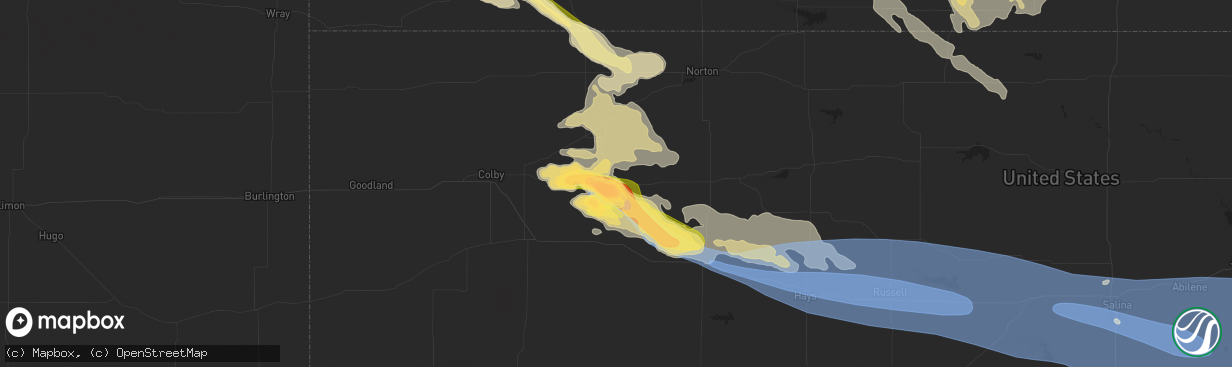
Wind
Hail
1,575
Estimated number of impacted properties by a 1.00" hail or larger1,208
Estimated number of impacted properties by a 1.75" hail or larger1,856
Estimated number of impacted properties by a 2.50" hail or largerStorm reports in Hoxie, KS
Hoxie, KS
| Date | Description |
|---|---|
| 06/07/20246:52 PM CDT | Estimated three inch diameter hail fell at the location. Time estimated via radar. |
| 06/07/20246:50 PM CDT | Reported via social media. Quarter to half dollar sized hail accumulating on the ground. North-side windows of a house broken from hail. |
| 06/07/20246:45 PM CDT | Spotter estimated dime to quarter sized hail. Hail was ongoing five minutes later. |
| 06/07/20246:45 PM CDT | Reported via social media. Approximately tennis ball sized hail fell in town over a duration of 15 minutes. Time sent be the reportee. |
| 06/07/20246:30 PM CDT | X picture of quarter and half dollar coins with numerous hail stones around them ranging from ping pong ball to golf ball. |
| 06/06/20247:16 PM CDT | Ambient weather site niermeier... Hoxie. |
| 06/06/20247:06 PM CDT | Golf ball to baseball sized hail falling currently in hoxie. Broken windshields reported along with street flooding due to accumulation of hail. |
| 06/06/20247:06 PM CDT | Golf ball to baseball sized hail falling currently in hoxie. Broken windshields reported along with street flooding due to accumu |
| 06/06/20247:05 PM CDT | Time estimated via radar. Reported via social media of a hail stone measured at 3 inches. |
| 06/06/20247:00 PM CDT | Golf ball sized hail reported over a duration of five minutes. |
| 06/06/20247:00 PM CDT | Delayed report of large... Anchored... Metal shed tossed into nearby field. Shed was used to house tractor-trailers. Location and time are estimated. |
All States Impacted by Hail Map on June 7, 2024
All Cities Impacted by Hail Map on June 7, 2024
- Amarillo, TX
- Panhandle, TX
- Canyon, TX
- Claude, TX
- Happy, TX
- Wayside, TX
- Keeseville, NY
- Plattsburgh, NY
- Peru, NY
- Hialeah, FL
- Opa Locka, FL
- Hollywood, FL
- Fort Lauderdale, FL
- Arriba, CO
- Mora, NM
- Mullen, NE
- Buena Vista, NM
- Rainsville, NM
- Pompano Beach, FL
- Boca Raton, FL
- Seneca, NE
- Delray Beach, FL
- Thedford, NE
- Flagler, CO
- Clewiston, FL
- Vergennes, VT
- Lake Worth, FL
- Boynton Beach, FL
- Labelle, FL
- Johnstown, NE
- Elsmere, NE
- Westport, NY
- Imperial, NE
- Bridport, VT
- Ferrisburgh, VT
- Kim, CO
- Springfield, CO
- New Haven, VT
- Starksboro, VT
- Pueblo, CO
- Avondale, CO
- Boone, CO
- Pritchett, CO
- Grenville, NM
- Moore Haven, FL
- Ainsworth, NE
- Long Pine, NE
- Dunning, NE
- Arnold, NE
- Halsey, NE
- Stapleton, NE
- Raton, NM
- Enders, NE
- Two Buttes, CO
- North Platte, NE
- Wauneta, NE
- Las Vegas, NM
- Okeechobee, FL
- Brewster, NE
- Palisade, NE
- Taylor, NE
- Bassett, NE
- Maxwell, NE
- Burwell, NE
- Syracuse, KS
- Fort Pierce, FL
- Anselmo, NE
- Hugoton, KS
- Stratton, NE
- Solano, NM
- Clayton, NM
- Trenton, NE
- Culbertson, NE
- Elyria, NE
- Moscow, KS
- Conchas Dam, NM
- Merna, NE
- Broken Bow, NE
- Trementina, NM
- Ord, NE
- Ericson, NE
- Elkhart, KS
- Goodwell, OK
- McCook, NE
- Oberlin, KS
- Lakin, KS
- Scotia, NE
- Selden, KS
- Ansley, NE
- Felt, OK
- Boise City, OK
- Callaway, NE
- Greeley, NE
- Dresden, KS
- Danbury, NE
- Rexford, KS
- North Loup, NE
- Liberal, KS
- Hoxie, KS
- Burlington, CO
- Bethune, CO
- Garita, NM
- Norcatur, KS
- Hooker, OK
- Jennings, KS
- Mason City, NE
- Wolbach, NE
- Spalding, NE
- Walsh, CO
- Campo, CO
- Keyes, OK
- Kenton, OK
- Dalhart, TX
- Texline, TX
- Sedan, NM
- Texhoma, OK
- Stratford, TX
- Rolla, KS
- Kanorado, KS
- Norton, KS
- Saint Paul, NE
- Palmer, NE
- Cedar Rapids, NE
- Stratton, CO
- Hazard, NE
- Litchfield, NE
- Oconto, NE
- Pleasanton, NE
- Weskan, KS
- Keldron, SD
- Morristown, SD
- Lemmon, SD
- Rigby, ID
- Menan, ID
- Central City, NE
- Fullerton, NE
- Guymon, OK
- Morland, KS
- Clarks, NE
- Ravenna, NE
- Osceola, NE
- Watauga, SD
- Goodland, KS
- Archer, NE
- Clayton, KS
- McIntosh, SD
- Miller, NE
- Sumner, NE
- Amherst, NE
- Stromsburg, NE
- Polk, NE
- Hordville, NE
- Silver Creek, NE
- Gibbon, NE
- McLaughlin, SD
- Penokee, KS
- Shelton, NE
- Lexington, NE
- Eddyville, NE
- Quinter, KS
- Collyer, KS
- Timber Lake, SD
- Hardesty, OK
- Wood River, NE
- Hill City, KS
- Riverdale, NE
- Kearney, NE
- Overton, NE
- Wakeeney, KS
- Bogue, KS
- Isabel, SD
- Elm Creek, NE
- Palco, KS
- Minden, NE
- Bertrand, NE
- Eagle Butte, SD
- Kenesaw, NE
- Loomis, NE
- Park, KS
- Grainfield, KS
- Grinnell, KS
- Heartwell, NE
- Odessa, NE
- Axtell, NE
- Ellis, KS
- Plainville, KS
- Doniphan, NE
- Holdrege, NE
- Juniata, NE
- Ogallah, KS
- Hastings, NE
- Funk, NE
- Hays, KS
- Surprise, NE
- Shelby, NE
- Rising City, NE
- Dwight, NE
- Ulysses, NE
- Valparaiso, NE
- Pleasant Dale, NE
- Bee, NE
- Raymond, NE
- Garland, NE
- Seward, NE
- Gresham, NE
- Staplehurst, NE
- Malcolm, NE
- Perryton, TX
- Bladen, NE
- Holstein, NE
- Campbell, NE
- Roseland, NE
- Catharine, KS
- Natoma, KS
- Victoria, KS
- Upland, NE
- Wilcox, NE
- Hildreth, NE
- Blue Hill, NE
- Naponee, NE
- Bloomington, NE
- Gorham, KS
- Franklin, NE
- Riverton, NE
- Republican City, NE
- Smith Center, KS
- Bennet, NE
- Lincoln, NE
- Walton, NE
- Roca, NE
- Davey, NE
- Ceresco, NE
- Palmyra, NE
- Walker, KS
- Paradise, KS
- Russell, KS
- Bunker Hill, KS
- Dorrance, KS
- Lawrence, NE
- Deweese, NE
- Nelson, NE
- Fairfield, NE
- Sylvan Grove, KS
- Luray, KS
- Lucas, KS
- Glenvil, NE
- Red Cloud, NE
- Waldo, KS
- Wilson, KS
- Edgar, NE
- Guide Rock, NE
- Inavale, NE
- Lebanon, KS
- Superior, NE
- Lincoln, KS
- Lorraine, KS
- Holyrood, KS
- Ellsworth, KS
- Claflin, KS
- Kanopolis, KS
- Beverly, KS
- Esbon, KS
- Oak, NE
- Brookville, KS
- Tescott, KS
- Salina, KS
- Marquette, KS
- Geneseo, KS
- Falun, KS
- Ruskin, NE
- Deshler, NE
- Hardy, NE
- Mankato, KS
- Republic, KS
- Burr Oak, KS
- Byron, NE
- Courtland, KS
- Hebron, NE
- Belleville, KS
- Chester, NE
- Gilead, NE
- Fairbury, NE
- Reynolds, NE
- Morrowville, KS
- Diller, NE
- Endicott, NE
- Steele City, NE
- Hollenberg, KS
- New Cambria, KS
- Lindsborg, KS
- Assaria, KS
- Mcpherson, KS
- Gypsum, KS
- Scandia, KS
- Jewell, KS
- Agenda, KS
- Galva, KS
- Roxbury, KS
- Canton, KS
- Hope, KS
- Solomon, KS
- Abilene, KS
- Tampa, KS
- Durham, KS
- Seneca, KS
- Washington, KS
- Herington, KS
- Lehigh, KS
- Wetmore, KS
- Sabetha, KS
- Goff, KS
- Saint Marys, KS
- Belvue, KS
- Emmett, KS
- Osage City, KS
- White City, KS
- Woodbine, KS
- Delia, KS
- Hillsboro, KS
- Fairview, KS
- Lost Springs, KS
- Ramona, KS
- Lincolnville, KS
- Florence, KS
- Peabody, KS
- Enterprise, KS
- Marion, KS
- Strong City, KS
- Chapman, KS
- Junction City, KS
- Dwight, KS
- Alta Vista, KS
- Elmdale, KS
- Burdick, KS
- Council Grove, KS
- Wilsey, KS
- Cedar Point, KS
- Lyndon, KS
- Mayetta, KS
- Gardner, KS
- Spring Hill, KS
- Bucyrus, KS
- Olathe, KS
- New Century, KS
- Hoyt, KS
- Allen, KS
- Quenemo, KS
- Burns, KS
- Emporia, KS
- Matfield Green, KS
- Cottonwood Falls, KS
- Olpe, KS
- Americus, KS
- Reading, KS
- Alma, KS
- Admire, KS
- Stilwell, KS
- Cleveland, MO
- Belton, MO
- Peculiar, MO
- Freeman, MO
- Topeka, KS
- Newton, KS
- Pomona, KS
- Meriden, KS
- Lebo, KS
- Melvern, KS
- Overland Park, KS
- Princeton, KS
- Ottawa, KS
- Hartford, KS
- Madison, KS
- Neosho Rapids, KS
- Burlington, KS
- Rantoul, KS
- Elbing, KS
- Greeley, KS
- Louisburg, KS
- Waverly, KS
- Leawood, KS
- Kansas City, MO
- Harrisonville, MO
- Osawatomie, KS
- Fontana, KS
- Grandview, MO
- Lees Summit, MO
- Westphalia, KS
- Le Roy, KS
- Mayhill, NM
- Richmond, KS
- Garnett, KS
- Williamsburg, KS
- Raymore, MO
- Colony, KS
- Welda, KS
- Kincaid, KS
- Parker, KS
- Lane, KS
- Whitehorse, SD
- Piqua, KS
- Bronson, KS
- Moran, KS
- Iola, KS
- La Harpe, KS
- Humboldt, KS
- Neosho Falls, KS
- Yates Center, KS
- Savonburg, KS
- Elsmore, KS
- Chanute, KS
- Erie, KS
- Mindenmines, MO
- Liberal, MO
- Uniontown, KS
- Redfield, KS
- Richards, MO
- Torrington, WY
- McCune, KS
- Stark, KS
- Sheldon, MO
- Lamar, MO
- Stockton, MO
- Jerico Springs, MO
- El Dorado Springs, MO
- Jasper, MO
- Arcola, MO
- Everton, MO
- Walnut Grove, MO
- Lockwood, MO
- Ash Grove, MO
- Golden City, MO
- Pleasant Hill, MO
- Carthage, MO
- Marionville, MO
- Republic, MO
- Bois D Arc, MO
- La Russell, MO
- Miller, MO
- South Greenfield, MO
- Greenfield, MO
- Willard, MO
- Stotts City, MO
- Mount Vernon, MO
- Rogersville, MO
- Ozark, MO
- Billings, MO
- Chadwick, MO
- Richfield, KS
- Walnut Shade, MO
- Reeds Spring, MO
- Highlandville, MO
- Crane, MO
- Galena, MO
- Garrison, MO
- Forsyth, MO
- Buffalo, OK
- Taneyville, MO
- Bradleyville, MO
- Oldfield, MO
- Ava, MO
- Rockaway Beach, MO
- Branson, MO
- Kissee Mills, MO
- Thornfield, MO
- Ridgedale, MO
- Hollister, MO
- Alpena, AR
- Fayetteville, AR
- Byers, CO
- Strasburg, CO
- Deer Trail, CO
- Agate, CO
- Limon, CO
- Fleming, CO
- Haxtun, CO
- Paoli, CO
- Holyoke, CO
- Wray, CO
- Yuma, CO
- Sterling, CO
- Atwood, CO
- Tyrone, OK
- Turpin, OK
- Kismet, KS
- Moundridge, KS
- Goessel, KS
- Walton, KS
- Eskridge, KS
- Marysville, KS
- Home, KS
- Valley Falls, KS
- Nortonville, KS
- Atchison, KS
- Winchester, KS
- Easton, KS
- Platte City, MO
- Leavenworth, KS
- Oskaloosa, KS
- Fort Leavenworth, KS
- Lansing, KS
- Waldron, MO
- Farley, MO
- McLouth, KS
- Kansas City, KS
- Lawrence, KS
- Tonganoxie, KS
- Basehor, KS
- Linwood, KS
- Ozawkie, KS
- De Soto, KS
- Bonner Springs, KS
- Riverside, MO
- Shawnee, KS


