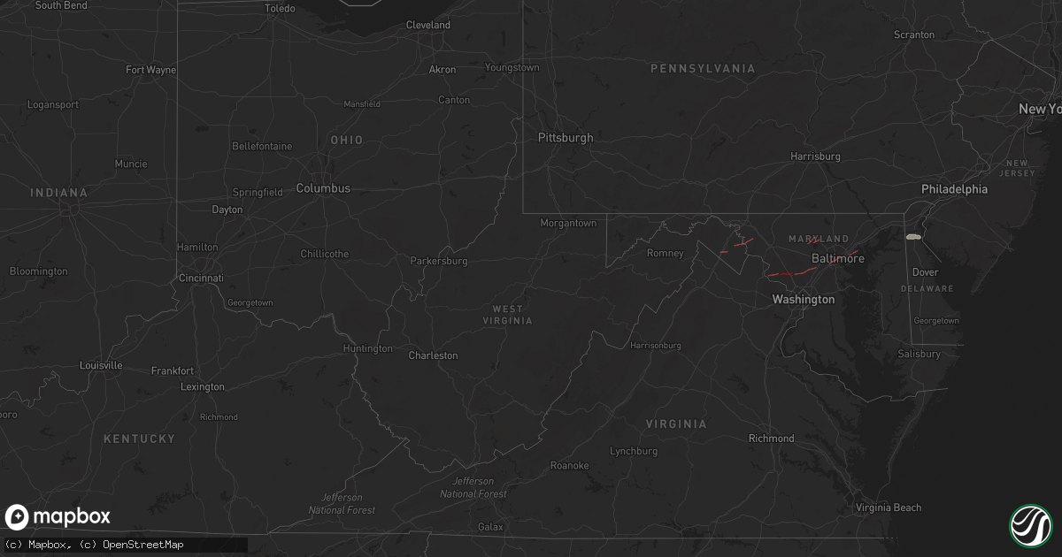
Hail Map in West Virginia on June 5, 2024
Get this storm
June 5 map
$229
one time, instant access
Download today. No call, no setup
Keep the $229
Bought the map and want the full workflow? Apply the entire $229 to a subscription within 7 days. None of it is wasted.
Every map, not just this one
This buys you this map. Subscription and you get every map we run, in the markets you choose from a few cities to whole states to nationwide. Plus real-time alerts the moment a storm fires.
Contact data
Name, contact info, occupancy, even credit band for addresses in the footprint. You go from where it hit to who to call.
Become the source they trust
Unlimited branding weather history reports on demand. You already have the documented answer ready for the property owner, and you are the one who showed up with it.
Property data and RoofTrace estimates
Pull up any address you have got, its value and the exact code rules for that jurisdiction, straight from One Click Code. Then RoofTrace estimates the squares, pitch, and roof value, priced the way you price.
Storm reports in West Virginia
West Virginia
| Date | Description |
|---|---|
| 06/05/20243:58 PM CDT | Tornadic signature on radar from circulation crossing potomac farms drive & comegy drive. Multiple trees down with road closed. |
| 06/05/20243:57 PM CDT | Tornadic signature on radar from circulation crossing kearneysville pike & shveda way. Multiple trees down with road closed. |
| 06/05/20243:32 PM CDT | Tree down near the intersection of charles town road and short road |
| 06/05/20243:27 PM CDT | Video sent of tornado on the ground... Likely near route 9 and short road near the berkeley/jefferson county line. |
| 06/05/20243:25 PM CDT | Tree down near the intersection of short road and opequon lane |
| 06/05/20243:04 PM CDT | Numerous trees down along emery lane in inwood. |
All States Impacted by Hail Map on June 5, 2024
Cities Impacted by Hail Map on June 5, 2024
- Arlington, TX
- Grand Prairie, TX
- Mansfield, TX
- Midlothian, TX
- Cedar Hill, TX
- Whitney, TX
- Aquilla, TX
- Valley Mills, TX
- West, TX
- Waco, TX
- Clifton, TX
- Rantoul, IL
- China Spring, TX
- Thomasboro, IL
- Gifford, IL
- Woodway, TX
- Crawford, TX
- Oglesby, TX
- McGregor, TX
- Moody, TX
- Hewitt, TX
- Galveston, TX
- Champaign, IL
- Saint Joseph, IL
- New Durham, NH
- Live Oak, FL
- Bridgton, ME
- Denmark, ME
- Port Lavaca, TX
- Jasper, FL
- Victoria, TX
- Harrison, ME
- Naples, ME
- Jennings, FL
- Ventress, LA
- Wabasha, MN
- Alma, WI
- Kellogg, MN
- Altura, MN
- Cochrane, WI
- Arcadia, WI
- Gorham, ME
- Standish, ME
- Buxton, ME
- Eldorado, TX
- Sonora, TX
- Casco, ME
- Gray, ME
- Oxford, ME
- Portsmouth, NH
- Durham, NH
- Greenland, NH
- Windham, ME
- New Gloucester, ME
- Raymond, ME
- Howland, ME
- Dover, NH
- Madbury, NH
- Exeter, ME
- Corinth, ME
- Charleston, ME
- Garland, ME
- Lagrange, ME
- Minden City, MI
- Dover Foxcroft, ME
- Leesburg, VA
- Paeonian Springs, VA
- Old Town, ME
- Hope, ME
- Springfield, ME
- Orangeburg, SC
- Saint Matthews, SC
- Searsmont, ME
- Lincolnville, ME
- Milford, ME
- Greenbush, ME
- Poolesville, MD
- Boyds, MD
- Newmarket, NH
- Germantown, MD
- Eliot, ME
- Hudson, ME
- Gaithersburg, MD
- Orono, ME
- Wagener, SC
- Derwood, MD
- Tremont, MS
- Hamilton, AL
- Olney, MD
- Stratham, NH
- Hilliard, FL
- Sykesville, MD
- Finksburg, MD
- Reisterstown, MD
- Ozona, TX
- Gainesville, FL
- Sandy Spring, MD
- Ashton, MD
- Highland, MD
- Fulton, MD
- Clarksville, MD
- Columbia, MD
- Hodges, AL
- Spruce Pine, AL
- McCamey, TX
- Brookston, MN
- Centerburg, OH
- Micanopy, FL
- Reddick, FL
- Baltimore, MD
- Halethorpe, MD
- Dickerson, MD
- Cottondale, AL
- Middle River, MD
- Bellefontaine, OH
- Essex, MD
- Summerfield, FL
- Leesville, SC
- Batesburg, SC
- Calumet, MI
- Hancock, MI
- Roscommon, MI
- Mohawk, MI
- Del Rio, TX
- Upperco, MD
- Pikesville, MD
- Owings Mills, MD
- Glyndon, MD
- Stevenson, MD
- Westminster, MD
- Taneytown, MD
- Northport, AL
- Sweet Water, AL
- Bunker Hill, WV
- Inwood, WV
- Newbern, AL
- Faunsdale, AL
- Rocksprings, TX
- Shepherdstown, WV
- Middletown, DE
- Sharpsburg, MD
- Keedysville, MD
- Boonsboro, MD
- Rock, MI
- Ellabell, GA
- Bloomingdale, GA
- Nashport, OH
- Frazeysburg, OH
- Saint Francisville, LA
- Claude, TX
- Amarillo, TX
- Canyon, TX
- Wayside, TX
- Happy, TX
- Winfield, AL
- Eldridge, AL
- Carbon Hill, AL
- Nauvoo, AL
- Madison, AL
- Harvest, AL
- Huntsville, AL


