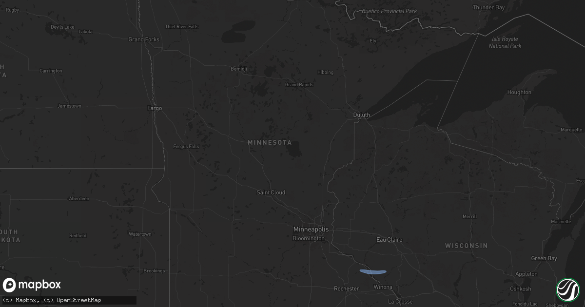
Hail Map in Minnesota on June 5, 2024
Get this storm
June 5 map
$229
one time, instant access
Download today. No call, no setup
Keep the $229
Bought the map and want the full workflow? Apply the entire $229 to a subscription within 7 days. None of it is wasted.
Every map, not just this one
This buys you this map. Subscription and you get every map we run, in the markets you choose from a few cities to whole states to nationwide. Plus real-time alerts the moment a storm fires.
Contact data
Name, contact info, occupancy, even credit band for addresses in the footprint. You go from where it hit to who to call.
Become the source they trust
Unlimited branding weather history reports on demand. You already have the documented answer ready for the property owner, and you are the one who showed up with it.
Property data and RoofTrace estimates
Pull up any address you have got, its value and the exact code rules for that jurisdiction, straight from One Click Code. Then RoofTrace estimates the squares, pitch, and roof value, priced the way you price.
Storm reports in Minnesota
Minnesota
| Date | Description |
|---|---|
| 06/05/20246:35 PM CDT | Awos station ksyn stanton ap. |
| 06/05/20246:35 PM CDT | Awos station ksyn st |
| 06/05/20246:25 PM CDT | Large tree down on powerlines. Reported via x. |
| 06/05/20246:15 PM CDT | Mn dot observation on i-94. |
| 06/05/20245:20 PM CDT | Tree on powerline. Winds made it feel like their car was going to be blown off the road. |
| 06/05/20245:10 PM CDT | A photo of a tree fallen down over a fence in the north side of cloquet area was shared via facebook. The tree was large enough to cause damage to the fence upon fallin |
| 06/05/20245:04 PM CDT | Report from mping: trees uprooted or snapped. |
| 06/05/20244:54 PM CDT | A local report indicates 62 MPH wind near Park Rapids |
| 06/05/20244:54 PM CDT | Picture via social media. Several trees downed on the pokegama golf course. Time estimated from report and radar. |
| 06/05/20243:45 PM CDT | Broke tree branches 4 to 6 inches in diamter... Along with an old spruce. |
| 06/05/20242:57 PM CDT | Picture via social media of a large pine tree fallen across 5th avenue in virginia. Time estimated from radar. |
| 06/05/20242:20 PM CDT | Mesonet station mn069 u.s.61 - kellogg - mp 53. |
All States Impacted by Hail Map on June 5, 2024
Cities Impacted by Hail Map on June 5, 2024
- Arlington, TX
- Grand Prairie, TX
- Mansfield, TX
- Midlothian, TX
- Cedar Hill, TX
- Whitney, TX
- Aquilla, TX
- Valley Mills, TX
- West, TX
- Waco, TX
- Clifton, TX
- Rantoul, IL
- China Spring, TX
- Thomasboro, IL
- Gifford, IL
- Woodway, TX
- Crawford, TX
- Oglesby, TX
- McGregor, TX
- Moody, TX
- Hewitt, TX
- Galveston, TX
- Champaign, IL
- Saint Joseph, IL
- New Durham, NH
- Live Oak, FL
- Bridgton, ME
- Denmark, ME
- Port Lavaca, TX
- Jasper, FL
- Victoria, TX
- Harrison, ME
- Naples, ME
- Jennings, FL
- Ventress, LA
- Wabasha, MN
- Alma, WI
- Kellogg, MN
- Altura, MN
- Cochrane, WI
- Arcadia, WI
- Gorham, ME
- Standish, ME
- Buxton, ME
- Eldorado, TX
- Sonora, TX
- Casco, ME
- Gray, ME
- Oxford, ME
- Portsmouth, NH
- Durham, NH
- Greenland, NH
- Windham, ME
- New Gloucester, ME
- Raymond, ME
- Howland, ME
- Dover, NH
- Madbury, NH
- Exeter, ME
- Corinth, ME
- Charleston, ME
- Garland, ME
- Lagrange, ME
- Minden City, MI
- Dover Foxcroft, ME
- Leesburg, VA
- Paeonian Springs, VA
- Old Town, ME
- Hope, ME
- Springfield, ME
- Orangeburg, SC
- Saint Matthews, SC
- Searsmont, ME
- Lincolnville, ME
- Milford, ME
- Greenbush, ME
- Poolesville, MD
- Boyds, MD
- Newmarket, NH
- Germantown, MD
- Eliot, ME
- Hudson, ME
- Gaithersburg, MD
- Orono, ME
- Wagener, SC
- Derwood, MD
- Tremont, MS
- Hamilton, AL
- Olney, MD
- Stratham, NH
- Hilliard, FL
- Sykesville, MD
- Finksburg, MD
- Reisterstown, MD
- Ozona, TX
- Gainesville, FL
- Sandy Spring, MD
- Ashton, MD
- Highland, MD
- Fulton, MD
- Clarksville, MD
- Columbia, MD
- Hodges, AL
- Spruce Pine, AL
- McCamey, TX
- Brookston, MN
- Centerburg, OH
- Micanopy, FL
- Reddick, FL
- Baltimore, MD
- Halethorpe, MD
- Dickerson, MD
- Cottondale, AL
- Middle River, MD
- Bellefontaine, OH
- Essex, MD
- Summerfield, FL
- Leesville, SC
- Batesburg, SC
- Calumet, MI
- Hancock, MI
- Roscommon, MI
- Mohawk, MI
- Del Rio, TX
- Upperco, MD
- Pikesville, MD
- Owings Mills, MD
- Glyndon, MD
- Stevenson, MD
- Westminster, MD
- Taneytown, MD
- Northport, AL
- Sweet Water, AL
- Bunker Hill, WV
- Inwood, WV
- Newbern, AL
- Faunsdale, AL
- Rocksprings, TX
- Shepherdstown, WV
- Middletown, DE
- Sharpsburg, MD
- Keedysville, MD
- Boonsboro, MD
- Rock, MI
- Ellabell, GA
- Bloomingdale, GA
- Nashport, OH
- Frazeysburg, OH
- Saint Francisville, LA
- Claude, TX
- Amarillo, TX
- Canyon, TX
- Wayside, TX
- Happy, TX
- Winfield, AL
- Eldridge, AL
- Carbon Hill, AL
- Nauvoo, AL
- Madison, AL
- Harvest, AL
- Huntsville, AL


