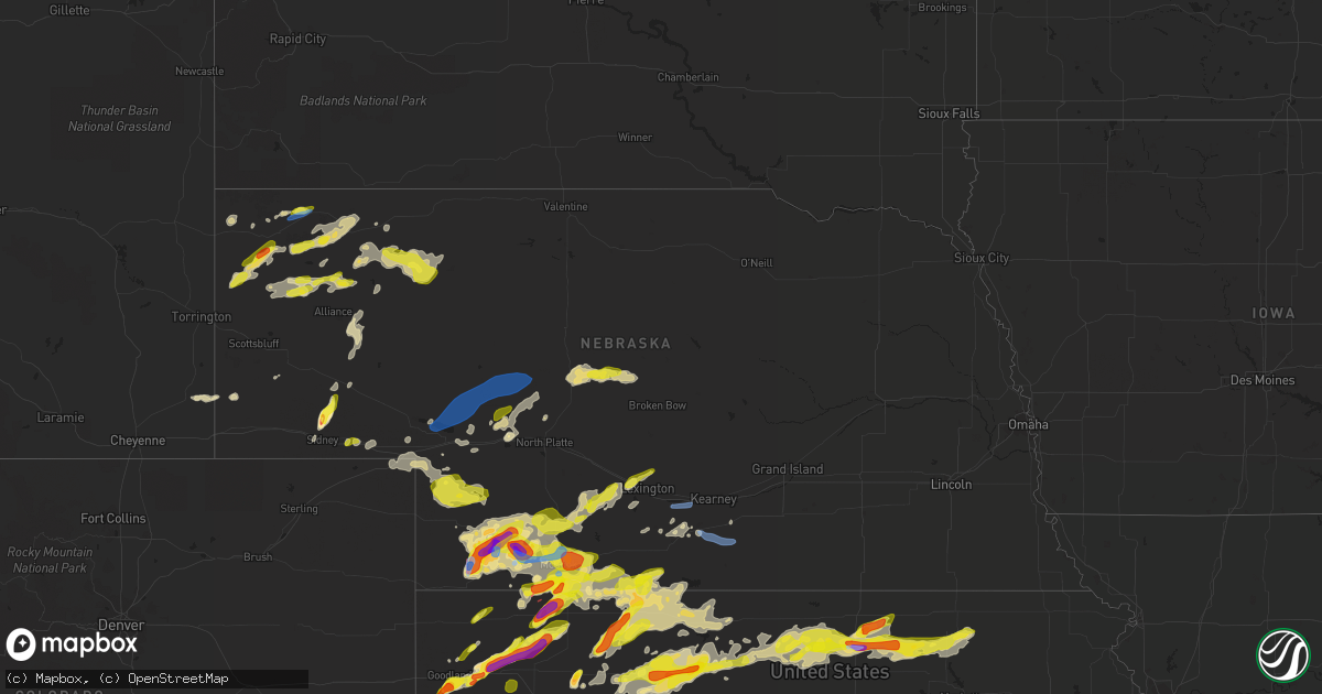
Hail Map in Nebraska on May 26, 2021
Get this storm
May 26 map
$229
one time, instant access
Download today. No call, no setup
Keep the $229
Bought the map and want the full workflow? Apply the entire $229 to a subscription within 7 days. None of it is wasted.
Every map, not just this one
This buys you this map. Subscription and you get every map we run, in the markets you choose from a few cities to whole states to nationwide. Plus real-time alerts the moment a storm fires.
Contact data
Name, contact info, occupancy, even credit band for addresses in the footprint. You go from where it hit to who to call.
Become the source they trust
Unlimited branding weather history reports on demand. You already have the documented answer ready for the property owner, and you are the one who showed up with it.
Property data and RoofTrace estimates
Pull up any address you have got, its value and the exact code rules for that jurisdiction, straight from One Click Code. Then RoofTrace estimates the squares, pitch, and roof value, priced the way you price.
Storm reports in Nebraska
Nebraska
| Date | Description |
|---|---|
| 05/26/20216:52 PM CDT | A local report indicates 63 MPH wind near 7 SSE SIDNEY |
| 05/26/20216:46 PM CDT | From 543 to 546 pm mdt. |
| 05/26/20216:40 PM CDT | A local report indicates 1.00 inch wind near 8 NE DALTON |
| 05/26/20216:30 PM CDT | A local report indicates 1.00 inch wind near GURLEY |
| 05/26/20216:15 PM CDT | Report via social media... Estimated dime to quarter size hail. Between 6pm and 7pm... Timing estimated by radar. |
| 05/26/20216:15 PM CDT | A local report indicates 1.00 inch wind near GURLEY |
| 05/26/20216:15 PM CDT | A local report indicates 2.75 inch wind near GURLEY |
| 05/26/20216:02 PM CDT | Hail reported falling from 502 to 506 pm. |
| 05/26/20216:00 PM CDT | Hail atleast this size. |
| 05/26/20215:58 PM CDT | A local report indicates 1.00 inch wind near 2 S CHADRON STATE PARK |
| 05/26/20215:58 PM CDT | Report via spotter network |
| 05/26/20215:47 PM CDT | Off-duty nws employee reports a tornado that lasted about 5 min while looking w/nw of danbury. |
| 05/26/20215:43 PM CDT | Updated information of starting at 443 and lasting for close to ten minutes. Multiple trained spotter reports... Video... And pictures confirm a short tornado touch dow |
| 05/26/20215:27 PM CDT | Report from mping: quarter |
| 05/26/20215:26 PM CDT | Time estimated from radar. |
| 05/26/20215:25 PM CDT | A local report indicates 2.50 inch wind near 12 N MAX |
| 05/26/20215:25 PM CDT | Report via social media. |
| 05/26/20215:23 PM CDT | Spotter was located in extreme southern chase county looking south. |
| 05/26/20215:19 PM CDT | A local report indicates 1.75 inch wind near 13 NW STRATTON |
| 05/26/20215:11 PM CDT | Public reported tornado. |
| 05/26/20215:03 PM CDT | New tornado on ground with east circulation at mm16 on hwy 61. |
| 05/26/20214:55 PM CDT | Tornado still on the ground... Starting to rope out. Golf ball size hail reported as well. |
| 05/26/20214:51 PM CDT | Trained spotter located to the east of the storm in northwest hitchcock county reported they can see the tornado in dundy county. It was reported as a stove pipe tornad |
| 05/26/20214:48 PM CDT | Power outages at red cloud campground and tree limb broken. |
| 05/26/20214:48 PM CDT | A local report indicates 1.00 inch wind near 4 NW CHADRON |
| 05/26/20214:46 PM CDT | Delayed report by trained spotter. |
| 05/26/20214:39 PM CDT | Corrects previous tornado report from 4 n benkelman. Report of stovepipe tornado on the ground on hwy 61... Telephone poles and trees down remaining over open country. |
| 05/26/20214:39 PM CDT | An ef-2 tornado occurred shortly after the brief ef-0 north of benkelman. Damage consisted of many broken power poles... A large grove of elm trees that were demolished |
| 05/26/20214:26 PM CDT | A local report indicates a tornado near 6 N BENKELMAN |
| 05/26/20214:25 PM CDT | A brief tornado occurred 5 miles north of benkelman. Damage consisted of some metal roofing panels... A shed was thrown 200 yards... And fencing was damaged. The tornad |
| 05/26/20214:16 PM CDT | A local report indicates 1.25 inch wind near 7 ENE AGATE |
| 05/26/20212:15 PM CDT | Delayed report. |
| 05/26/20215:13 AM CDT | At 1012 PM CDT, a severe thunderstorm was located near Stamford, or 23 miles northeast of Norton, moving east at 30 mph. HAZARD...60 mph wind gusts and quarter size hail. SOURCE...Radar indicated. IMPACT...Hail damage to vehicles is expected. Expect wind damage to roofs, siding, and trees. This severe thunderstorm will be near... Stamford around 1020 PM CDT.Other locations in the path of this severe thunderstorm includeOrleans, Alma, Huntley and Ragan. |
| 05/26/20214:17 AM CDT | At 917 PM CDT/817 PM MDT/, a severe thunderstorm was located near Tryon, moving northeast at 50 mph. HAZARD...60 mph wind gusts and penny size hail. SOURCE...Radar indicated. IMPACT...Expect damage to roofs, siding, and trees. Locations impacted include... Stapleton, Thedford, Tryon, Halsey, Seneca, Gandy, Ringgold, Logan, Highway 83 crossing The Dismal River, East Cody Lake, Shanklin Bluff, Tarboz Lake, Hoagland, Brown Lake, Norway, Highway 97 crossing the Dismal River, Natwick and Shimmons Lake.This includes the following highways... Highway 2 between mile markers 193 and 227. Highway 92 between mile markers 193 and 246. Highway 97 between mile markers 18 and 59. Highway 83 between mile markers 106 and 155. |
| 05/26/20214:14 AM CDT | At 914 PM CDT, a severe thunderstorm was located near Indianola, or 8 miles east of McCook, moving east at 30 mph. HAZARD...60 mph wind gusts and quarter size hail. SOURCE...Radar indicated. IMPACT...Hail damage to vehicles is expected. Expect wind damage to roofs, siding, and trees. This severe thunderstorm will be near... Bartley around 930 PM CDT. |
| 05/26/20213:44 AM CDT | At 844 PM CDT/744 PM MDT/, severe thunderstorms were located along a line extending from 10 miles northeast of Keystone to near Madrid, moving east at 30 mph. HAZARD...60 mph wind gusts and nickel size hail. SOURCE...Radar indicated. IMPACT...Expect damage to roofs, siding, and trees. Locations impacted include... Sutherland, Hershey, Paxton, Wallace, Madrid, Elsie, Dickens, Sarben, Keystone, Sutherland Reservoir State Recreation Area, Roscoe, Grainton, Coker, O'Fallons, Nevens, Broganville, Big Bald Hill and Birdwood.This includes the following highways... Highway 97 between mile markers 6 and 16. Interstate 80 in Nebraska between mile markers 132 and 173. |
| 05/26/20213:39 AM CDT | At 838 PM CDT/738 PM MDT/, severe thunderstorms were located along a line extending from near Arthur to 20 miles northeast of Kingsley Dam to 11 miles northeast of Keystone, moving northeast at 50 mph. HAZARD...70 mph wind gusts and quarter size hail. SOURCE...Radar indicated. IMPACT...Hail damage to vehicles is expected. Expect considerable tree damage. Wind damage is also likely to mobile homes, roofs, and outbuildings. Locations impacted include... Arthur, Tryon, Haythorn Lake, Flatts, Big Lamunyon Flats, McKeag, Calora, Big Bald Hill, Bucktail Lake, Sand Beach Lake, Three Mile Lake, Diamond Bar Lake, Bucktail and Schnick Lake.This includes the following highways... Highway 61 between mile markers 112 and 127. Highway 92 between mile markers 165 and 210. Highway 97 between mile markers 15 and 40. |
| 05/26/20213:30 AM CDT | At 830 PM CDT, a severe thunderstorm was located near Axtell, or 12 miles east of Holdrege, moving east at 35 mph. HAZARD...60 mph wind gusts and quarter size hail. SOURCE...Radar indicated. IMPACT...Hail damage to vehicles is expected. Expect wind damage to roofs, siding, and trees. This severe thunderstorm will be near... Hildreth around 840 PM CDT. Minden around 845 PM CDT. Upland around 850 PM CDT.Other locations in the path of this severe thunderstorm includeNorman and Campbell. |
| 05/26/20213:27 AM CDT | At 827 PM CDT, a severe thunderstorm was located 6 miles north of Culbertson, or 13 miles northeast of Trenton, moving east at 30 mph. HAZARD...Ping pong ball size hail and 60 mph wind gusts. SOURCE...Radar indicated. IMPACT...People and animals outdoors will be injured. Expect hail damage to roofs, siding, windows, and vehicles. Expect wind damage to roofs, siding, and trees. Locations impacted include... McCook. |
| 05/26/20213:04 AM CDT | At 804 PM CDT/704 PM MDT/, a severe thunderstorm was located over Enders Reservoir State Recreation Area, or 9 miles southeast of Imperial, moving east at 40 mph. HAZARD...60 mph wind gusts and half dollar size hail. SOURCE...Radar indicated. IMPACT...Hail damage to vehicles is expected. Expect wind damage to roofs, siding, and trees. Locations impacted include... Imperial, Hayes Center, Wauneta, Enders, Enders Reservoir State Recreation Area, Hamlet, Center Dam Campground, Marengo, Area A Campground, Hayes Center State Wildlife Management Area and Church Grove Campground.This includes Highway 61 between mile markers 25 and 30. |
| 05/26/20213:03 AM CDT | At 803 PM CDT, a severe thunderstorm was located 6 miles east of Herndon, or 7 miles northwest of Oberlin, moving northeast at 35 mph. HAZARD...Two inch hail and 60 mph wind gusts. SOURCE...Radar indicated. IMPACT...People and animals outdoors will be injured. Expect hail damage to roofs, siding, windows, and vehicles. Expect wind damage to roofs, siding, and trees. Locations impacted include... Danbury and Lebanon. |
| 05/26/20213:03 AM CDT | At 803 PM CDT, a severe thunderstorm was located over Palisade, or 10 miles south of Hayes Center, moving east at 30 mph. HAZARD...Ping pong ball size hail and 60 mph wind gusts. SOURCE...Radar indicated. IMPACT...People and animals outdoors will be injured. Expect hail damage to roofs, siding, windows, and vehicles. Expect wind damage to roofs, siding, and trees. Locations impacted include... Quick, Bluegill Haven Campground, Willow View Campground and Red Willow Reservoir State Recreation Area.This includes Highway 83 between mile markers 27 and 43. |
| 05/26/20212:48 AM CDT | At 748 PM CDT, a severe thunderstorm was located 4 miles west of Palisade, or 14 miles northwest of Trenton, moving northeast at 15 mph. HAZARD...60 mph wind gusts and quarter size hail. SOURCE...Radar indicated. IMPACT...Hail damage to vehicles is expected. Expect wind damage to roofs, siding, and trees. This severe thunderstorm will be near... Palisade around 805 PM CDT. |
| 05/26/20212:33 AM CDT | At 733 PM CDT, a severe thunderstorm was located 6 miles southeast of Indianola, or 15 miles east of McCook, moving northeast at 30 mph. HAZARD...60 mph wind gusts and quarter size hail. SOURCE...Radar indicated. IMPACT...Hail damage to vehicles is expected. Expect wind damage to roofs, siding, and trees. This severe thunderstorm will be near... Bartley around 740 PM CDT. |
| 05/26/20212:28 AM CDT | At 728 PM MDT, severe thunderstorms were located along a line extending from Grant to 13 miles southwest of Madrid to 9 miles northeast of Lamar, moving east at 35 mph. HAZARD...60 mph wind gusts and quarter size hail. SOURCE...Radar indicated. IMPACT...Hail damage to vehicles is expected. Expect wind damage to roofs, siding, and trees. Locations impacted include... Imperial, Grant, Wauneta, Madrid, Elsie, Enders, Enders Reservoir State Recreation Area, Chase, Grainton, Center Dam Campground, Wanamaker State Wildfire Management Area and Area A Campground.This includes Highway 61 between mile markers 29 and 69. |
| 05/26/20211:45 AM CDT | At 645 PM MDT, a severe thunderstorm was located near Julesburg, moving east at 35 mph. HAZARD...60 mph wind gusts and quarter size hail. SOURCE...Radar indicated. IMPACT...Expect damage to roofs, siding, and trees. Hail damage to vehicles is expected. Locations impacted include... Julesburg. |
| 05/26/20211:43 AM CDT | At 643 PM MDT, a severe thunderstorm was located 21 miles south of Gordon, moving east at 45 mph. HAZARD...60 mph wind gusts and quarter size hail. SOURCE...Radar indicated. IMPACT...Hail damage to vehicles is expected. Expect wind damage to roofs, siding, and trees. Locations impacted include... Highway 61 crossing the Snake River, Big Hill, Billys Lake, Morgan Lake, Intersection of Highway 61 and Shadbolt Road, Highway 27 crossing the Niobrara River and Intersection of Highway 61 and Survey Valley Road.This includes Highway 61 between mile markers 173 and 209. |
| 05/26/20211:21 AM CDT | At 621 PM MDT, a severe thunderstorm was located near Harrisburg, or 18 miles northwest of Kimball, moving east at 30 mph. HAZARD...Ping pong ball size hail and 60 mph wind gusts. SOURCE...Radar indicated. IMPACT...People and animals outdoors will be injured. Expect hail damage to roofs, siding, windows, and vehicles. Expect wind damage to roofs, siding, and trees. Locations impacted include... Harrisburg. |
| 05/26/20211:12 AM CDT | At 612 PM MDT, a severe thunderstorm was located near Hemingford, or 16 miles northwest of Alliance, moving east at 30 mph. HAZARD...Ping pong ball size hail and 60 mph wind gusts. SOURCE...Radar indicated. IMPACT...People and animals outdoors will be injured. Expect hail damage to roofs, siding, windows, and vehicles. Expect wind damage to roofs, siding, and trees. Locations impacted include... Alliance, Hemingford, Wild Horse Butte and Berea. |
| 05/26/202112:42 AM CDT | At 542 PM MDT, a severe thunderstorm was located near Sunol, or 12 miles west of Chappell, moving northeast at 10 mph. HAZARD...Golf ball size hail and 60 mph wind gusts. SOURCE...Radar indicated. IMPACT...People and animals outdoors will be injured. Expect hail damage to roofs, siding, windows, and vehicles. Expect wind damage to roofs, siding, and trees. This severe thunderstorm will be near... Lodgepole around 600 PM MDT.This includes Interstate 80 in Nebraska between mile markers 63 and77. |
| 05/26/202112:41 AM CDT | At 540 PM MDT, severe thunderstorms were located along a line extending from near Hemingford to 7 miles northwest of Kilpatrick Lake, moving east at 35 mph. HAZARD...Golf ball size hail and 60 mph wind gusts. SOURCE...Radar indicated. IMPACT...People and animals outdoors will be injured. Expect hail damage to roofs, siding, windows, and vehicles. Expect wind damage to roofs, siding, and trees. Locations impacted include... Hemingford, Wild Horse Butte, Kilpatrick Lake and Berea. |
| 05/26/202112:39 AM CDT | At 539 PM CDT, a severe thunderstorm was located 14 miles northeast of Gandy, or 15 miles northeast of Stapleton, moving east at 40 mph. HAZARD...60 mph wind gusts and quarter size hail. SOURCE...Radar indicated. IMPACT...Hail damage to vehicles is expected. Expect wind damage to roofs, siding, and trees. Locations impacted include... Dunning, Logan, Linscott, Shanklin Bluff, Tarboz Lake, Pleasant Hill, Hoagland and Brown Lake.This includes the following highways... Highway 2 between mile markers 237 and 249. Highway 92 between mile markers 253 and 261. Highway 83 between mile markers 115 and 124. |
| 05/26/202112:33 AM CDT | At 533 PM CDT, severe thunderstorms were located along a line extending from 6 miles east of Cozad to 7 miles northwest of Eustis, moving northeast at 20 mph. HAZARD...Ping pong ball size hail and 60 mph wind gusts. SOURCE...Radar indicated. At 527 PM CDT, the public reported quarter size hail in Darr. IMPACT...People and animals outdoors will be injured. Expect hail damage to roofs, siding, windows, and vehicles. Expect wind damage to roofs, siding, and trees. Locations impacted include... Lexington, Cozad, Gothenburg, Eddyville, Willow Island and Farnam. This includes Interstate 80 between mile markers 209 and 239. |
| 05/26/202112:30 AM CDT | At 530 PM MDT, a severe thunderstorm was located near Albin, or 31 miles northwest of Kimball, moving east at 15 mph. HAZARD...Ping pong ball size hail and 60 mph wind gusts. SOURCE...Radar indicated. IMPACT...People and animals outdoors will be injured. Expect hail damage to roofs, siding, windows, and vehicles. Expect wind damage to roofs, siding, and trees. This severe thunderstorm will be near... Albin around 545 PM MDT. |
| 05/26/202112:27 AM CDT | At 527 PM MDT, a severe thunderstorm was located near Dalton, or 17 miles north of Sidney, moving northeast at 35 mph. HAZARD...Ping pong ball size hail and 60 mph wind gusts. SOURCE...Public. IMPACT...People and animals outdoors will be injured. Expect hail damage to roofs, siding, windows, and vehicles. Expect wind damage to roofs, siding, and trees. Locations impacted include... Dalton, Gurley and Broadwater. |
| 05/26/202112:24 AM CDT | At 524 PM CDT, a severe thunderstorm was located near Curtis, moving northeast at 30 mph. HAZARD...60 mph wind gusts and quarter size hail. SOURCE...Radar indicated. IMPACT...Hail damage to vehicles is expected. Expect wind damage to roofs, siding, and trees. Locations impacted include... Curtis, Eustis, Moorefield, Stockville and Dancing Leaf Earth Lodge.This includes Highway 83 between mile markers 39 and 44. |
| 05/25/202111:51 PM CDT | At 451 PM CDT, a severe thunderstorm was located near Ludell, or 4 miles northeast of Atwood, moving northeast at 45 mph. HAZARD...60 mph wind gusts and half dollar size hail. SOURCE...Radar indicated. IMPACT...Hail damage to vehicles is expected. Expect wind damage to roofs, siding, and trees. This severe thunderstorm will be near... Herndon around 505 PM CDT.Other locations in the path of this severe thunderstorm includeCulbertson and McCook. |
| 05/25/202111:39 PM CDT | At 439 PM MDT, severe thunderstorms were located along a line extending from 7 miles east of Chadron to 9 miles north of Flahertys Corner, moving southeast at 15 mph. HAZARD...Ping pong ball size hail and 60 mph wind gusts. SOURCE...Radar indicated. IMPACT...People and animals outdoors will be injured. Expect hail damage to roofs, siding, windows, and vehicles. Expect wind damage to roofs, siding, and trees. Locations impacted include... Hemingford, Chadron Campground, Box Butte Campground, Red Cloud Campground, Box Butte Dam, Marsland and Chadron St Park. |
| 05/25/202111:33 PM CDT | At 432 PM CDT, a severe thunderstorm was located near Ringgold, or near Tryon, moving northeast at 35 mph. HAZARD...60 mph wind gusts and quarter size hail. SOURCE...Radar indicated. IMPACT...Hail damage to vehicles is expected. Expect wind damage to roofs, siding, and trees. Locations impacted include... Ringgold and Shanklin Bluff. This includes the following highways... Highway 92 between mile markers 206 and 222. Highway 97 between mile markers 17 and 26. Highway 83 between mile markers 116 and 123. |
| 05/25/202110:48 PM CDT | Davis weatherlink station. |
| 05/25/202110:45 PM CDT | At 343 PM MDT, a severe thunderstorm was located 8 miles south of Crawford, or 28 miles southwest of Chadron, moving east at 30 mph. HAZARD...Ping pong ball size hail and 60 mph wind gusts. SOURCE...Radar indicated. IMPACT...People and animals outdoors will be injured. Expect hail damage to roofs, siding, windows, and vehicles. Expect wind damage to roofs, siding, and trees. Locations impacted include... Crawford, Red Cloud Campground, Chadron Campground, Fort Robinson and Chadron St Park. |
| 05/25/202110:20 PM CDT | At 320 PM MDT, a severe thunderstorm was located near Whitney Lake, or 15 miles west of Chadron, moving northeast at 30 mph. HAZARD...60 mph wind gusts and quarter size hail. SOURCE...Radar indicated. IMPACT...Hail damage to vehicles is expected. Expect wind damage to roofs, siding, and trees. Locations impacted include... Northern Chadron, Whitney Lake, Chadron Airport and Whitney. |
| 05/25/202110:20 PM CDT | At 319 PM CDT/219 PM MDT/, a severe thunderstorm was located near Paxton, or 15 miles east of Ogallala, moving northeast at 30 mph. HAZARD...60 mph wind gusts and quarter size hail. SOURCE...Radar indicated. IMPACT...Hail damage to vehicles is expected. Expect wind damage to roofs, siding, and trees. Locations impacted include... Paxton, Sarben, Big Bald Hill, Nevens and Broganville. This includes Interstate 80 in Nebraska between mile markers 134 and150. |
| 05/25/202110:18 PM CDT | At 317 PM MDT/417 PM CDT/, a severe thunderstorm was located 4 miles north of Benkelman, moving northeast at 30 mph. HAZARD...Golf ball size hail and 60 mph wind gusts. SOURCE...Radar indicated. IMPACT...People and animals outdoors will be injured. Expect hail damage to roofs, siding, windows, and vehicles. Expect wind damage to roofs, siding, and trees. Locations impacted include... Stratton and Palisade. |
| 05/25/202110:08 PM CDT | At 307 PM MDT, a severe thunderstorm was located 10 miles northeast of Agate Bed National Monument, or 39 miles southwest of Chadron, moving northeast at 30 mph. HAZARD...Ping pong ball size hail and 60 mph wind gusts. SOURCE...Radar indicated. IMPACT...People and animals outdoors will be injured. Expect hail damage to roofs, siding, windows, and vehicles. Expect wind damage to roofs, siding, and trees. Locations impacted include... Crawford, Fort Robinson Campground, Fort Robinson and Marsland. |
| 05/25/20219:31 PM CDT | At 231 PM CDT, a severe thunderstorm was located over Stockville, or 8 miles southeast of Curtis, moving northeast at 35 mph. HAZARD...60 mph wind gusts and quarter size hail. SOURCE...Radar indicated. IMPACT...Hail damage to vehicles is expected. Expect wind damage to roofs, siding, and trees. Locations impacted include... Eustis, Stockville, Orafino and Dancing Leaf Earth Lodge. |
| 05/25/20219:30 PM CDT | Report from mping: 1-inch tree limbs broken; shingles blown off. |
| 05/25/20219:04 PM CDT | Pivot damaged from outflow winds likely around 70 mph. Time determined from land owners observation and radar information. |
| 05/25/20218:57 PM CDT | Nedor rwis station. |
| 05/25/20218:52 PM CDT | A local report indicates 60 MPH wind near 11 SE ARTHUR |
| 05/25/20218:52 PM CDT | A local report indicates 60 MPH wind near 11 SW ARTHUR |
| 05/25/20218:31 PM CDT | A local report indicates 1.00 inch wind near NNW GRANT |
| 05/25/20218:23 PM CDT | Golf ball to baseball size hail reported. |
| 05/25/20218:22 PM CDT | Estimated winds to be atleast 60 mph. This occurred with quarter size hail. |
| 05/25/20218:22 PM CDT | Occurred with estimated wind gusts of atleast 60 mph. |
| 05/25/20218:18 PM CDT | 1 inch hail reported by trained spotter |
| 05/25/20218:15 PM CDT | Report via social media. |
| 05/25/20218:05 PM CDT | Report from mping: quarter |
| 05/25/20218:04 PM CDT | A local report indicates 1.00 inch wind near 23 SSE GORDON |
| 05/25/20218:03 PM CDT | Multiple trained spotter reports... Video... And pictures confirm a short tornado touch down south of the agate fossil bed monument. No damage reported as it stayed in |
| 05/25/20218:00 PM CDT | Report via facebook. |
| 05/25/20217:25 PM CDT | A local report indicates 1.00 inch wind near 17 NNE ALLIANCE |
| 05/25/20217:05 PM CDT | A local report indicates 1.00 inch wind near LODGEPOLE |
All States Impacted by Hail Map on May 26, 2021
Cities Impacted by Hail Map on May 26, 2021
- Geneseo, KS
- Lorraine, KS
- New Cambria, KS
- Gypsum, KS
- Salina, KS
- Solomon, KS
- Clay Center, KS
- Greenleaf, KS
- Woodston, KS
- Linn, KS
- Kirwin, KS
- Green, KS
- Palco, KS
- Agenda, KS
- Alton, KS
- Jewell, KS
- Barnes, KS
- Jamestown, KS
- Damar, KS
- Hill City, KS
- Bogue, KS
- Cuba, KS
- Norway, KS
- Randall, KS
- Morland, KS
- Concordia, KS
- Downs, KS
- Clifton, KS
- Osborne, KS
- Esbon, KS
- Blue Rapids, KS
- Frankfort, KS
- Belleville, KS
- Clyde, KS
- Cawker City, KS
- Morganville, KS
- Waterville, KS
- Palmer, KS
- Randolph, KS
- Plainville, KS
- Beloit, KS
- Scandia, KS
- Mankato, KS
- Haddam, KS
- Portis, KS
- Stockton, KS
- Glen Elder, KS
- Penokee, KS
- Lance Creek, WY
- Lyons, KS
- Lenora, KS
- Ellis, KS
- Gillette, WY
- Upton, WY
- Albin, WY
- Dimmitt, TX
- Springlake, TX
- Earth, TX
- Hart, TX
- Poughquag, NY
- Stormville, NY
- Wappingers Falls, NY
- Poughkeepsie, NY
- Hopewell Junction, NY
- Lagrangeville, NY
- Muleshoe, TX
- Danbury, NE
- Oberlin, KS
- Monahans, TX
- Barstow, TX
- Stockville, NE
- Curtis, NE
- Edgemont, SD
- Thayer, KS
- Hemingford, NE
- Grant, NE
- McCune, KS
- Cozad, NE
- Lexington, NE
- Hays, KS
- Schoenchen, KS
- Ovid, CO
- Keystone, NE
- Holdrege, NE
- Phillipsburg, KS
- Little River, KS
- Windom, KS
- Hoxie, KS
- Benkelman, NE
- Palisade, NE
- Wauneta, NE
- Liebenthal, KS
- Victoria, KS
- Walker, KS
- La Crosse, KS
- Bison, KS
- McCook, NE
- Perryton, TX
- Imperial, NE
- Madrid, NE
- Elsie, NE
- Venango, NE
- Spearman, TX
- Gruver, TX
- Booker, TX
- Balko, OK
- Culbertson, NE
- Funk, NE
- Herndon, KS
- Mcpherson, KS
- Colby, KS
- Levant, KS
- Brewster, KS
- Anselmo, NE
- Arnold, NE
- Stapleton, NE
- Lovettsville, VA
- Waterford, VA
- Purcellville, VA
- Minden, NE
- Loomis, NE
- Crawford, NE
- Atwood, KS
- Kress, TX
- Tulia, TX
- Keymar, MD
- Rocky Ridge, MD
- Brookville, KS
- White Deer, TX
- Panhandle, TX
- Stratton, NE
- Enders, NE
- Trenton, NE
- Hayes Center, NE
- Max, NE
- Fall River, KS
- Canyon, TX
- Amarillo, TX
- Goodland, KS
- Gurley, NE
- Dalton, NE
- Belle Fourche, SD
- Quenemo, KS
- Osage City, KS
- Shippensburg, PA
- Biglerville, PA
- Saugerties, NY
- Russell, KS
- Bunker Hill, KS
- Gorham, KS
- Harveyville, KS
- Sutherland, NE
- Edson, KS
- Selden, KS
- Norcatur, KS
- Amherst, TX
- Fieldton, TX
- Hale Center, TX
- Olton, TX
- Littlefield, TX
- Gardners, PA
- Bechtelsville, PA
- Boyertown, PA
- Gilbertsville, PA
- Jonestown, PA
- Pine Grove, PA
- Annville, PA
- Sterling, CO
- Moorcroft, WY
- Emporia, KS
- Reading, KS
- White City, KS
- Council Grove, KS
- Annapolis Junction, MD
- Hanover, MD
- Savage, MD
- Laurel, MD
- Columbia, MD
- Elkridge, MD
- Jessup, MD
- Julesburg, CO
- Sudan, TX
- Plainview, TX
- Lincolnville, KS
- Marion, KS
- Tatum, NM
- Elwood, NE
- Bridgeport, NE
- Port Royal, PA
- Honey Grove, PA
- Hershey, NE
- Jal, NM
- Broadwater, NE
- Admire, KS
- Beaver, OK
- Hardesty, OK
- Manassas, VA
- Nokesville, VA
- Bristow, VA
- Lincoln, KS
- Ellsworth, KS
- Wilson, KS
- Alma, NE
- Wilsonville, NE
- Maywood, NE
- Almena, KS
- Prairie View, KS
- Oxford, NE
- Long Island, KS
- Bartley, NE
- Smith Center, KS
- Jennings, KS
- Agra, KS
- Moorefield, NE
- Kensington, KS
- Cambridge, NE
- Ludell, KS
- Farnam, NE
- Stamford, NE
- Gaylord, KS
- Logan, KS
- Lebanon, NE
- Clayton, KS
- Indianola, NE
- Glade, KS
- Beaver City, NE
- Norton, KS
- Eustis, NE
- Athol, KS
- Hendley, NE
- Orleans, NE
- Rockville Centre, NY
- Oceanside, NY
- Baldwin, NY
- Ellicott City, MD
- Boonsboro, MD
- Catlett, VA
- Benton, PA
- Harrisburg, NE
- Abernathy, TX
- Unityville, PA
- Millville, PA
- Clinton, MD
- Alexandria, VA
- Fort Washington, MD
- Bryans Road, MD
- Accokeek, MD
- Fort Belvoir, VA
- Hereford, TX
- Claflin, KS
- Holyrood, KS
- Marquette, KS
- Sylvan Grove, KS
- Dorrance, KS
- Waldo, KS
- Bushton, KS
- Hoisington, KS
- Moundridge, KS
- Inman, KS
- Chase, KS
- Canton, KS
- Galva, KS
- Kanopolis, KS
- Goessel, KS
- Gainesville, VA
- Watertown, CT
- Thomaston, CT
- Leesburg, VA
- Pampa, TX
- Merriman, NE
- Gordon, NE
- Bingham, NE
- Ashby, NE
- Wellington, KS
- Clifton, VA
- Lykens, PA
- Hegins, PA
- Valley View, PA
- Sacramento, PA
- Spring Glen, PA
- Tower City, PA
- Williamstown, PA
- Ephrata, PA
- Denver, PA
- Stevens, PA
- New Holland, PA
- Ogallah, KS
- Wakeeney, KS
- Oshkosh, NE
- Hay Springs, NE
- Ellsworth, NE
- Fort Davis, TX
- Fredericksburg, PA
- Pine Bluffs, WY
- Bel Air, MD
- Havre De Grace, MD
- Churchville, MD
- Mayfield, KS
- Fairfield, PA
- Spring Run, PA
- Dry Run, PA
- Newburg, PA
- Amberson, PA
- New Germantown, PA
- Dodge City, KS
- Ensign, KS
- Cimarron, KS
- Rushville, NE
- Chappell, NE
- Lodgepole, NE
- Burlingame, KS
- Lovington, NM
- Meshoppen, PA
- Mehoopany, PA
- Whitney, NE
- Harrison, NE
- Marsland, NE
- Hampton, CT
- Chaplin, CT
- Schuylkill Haven, PA
- Reading, PA
- Bird City, KS
- Chadron, NE
- Stoneham, CO
- Newcastle, WY
- East Earl, PA
- Anton, TX
- Germantown, NY
- Elizaville, NY
- Tivoli, NY
- Douglassville, PA
- Oley, PA
- Hamburg, PA
- Kutztown, PA
- Pottstown, PA
- Mertztown, PA
- Lyon Station, PA
- Fleetwood, PA
- Alburtis, PA
- Perkiomenville, PA
- Frederick, PA
- Barto, PA
- Blandon, PA
- Macungie, PA
- Leesport, PA
- Shoemakersville, PA
- Lakeside, NE
- Alliance, NE
- Skellytown, TX
- Waverly, KS
- Douglas, WY
- Weldona, CO
- Philadelphia, PA
- Camden, NJ
- Shallowater, TX
- McDonald, KS
- Fredonia, KS
- Longton, KS
- Elk City, KS
- Neodesha, KS
- Peetz, CO
- Padroni, CO
- Paxton, NE
- Haymarket, VA
- Broad Run, VA
- Warrenton, VA
- Lemoyne, PA
- Camp Hill, PA
- Morgantown, WV
- Fairmont, WV
- Red Hook, NY
- Brule, NE
- Big Springs, NE
- Champion, NE
- The Plains, VA
- North Platte, NE
- Montezuma, KS
- Durham, KS
- Lost Springs, KS
- Halstead, KS
- Peabody, KS
- Lehigh, KS
- Hesston, KS
- Newton, KS
- Walton, KS
- Roxbury, KS
- Hillsboro, KS
- Ramona, KS
- Tampa, KS
- Lindsborg, KS
- North Newton, KS
- Beverly, KS
- Pfeifer, KS
- Luray, KS
- McCracken, KS
- Lorton, VA
- Springfield, VA
- Reston, VA
- Fairfax Station, VA
- Herndon, VA
- Chantilly, VA
- McLean, VA
- Vienna, VA
- Oakton, VA
- Sterling, VA
- Centreville, VA
- Fairfax, VA
- Woodbridge, VA
- Great Falls, VA
- Catharpin, VA
- Eskridge, KS
- Darlington, MD
- Milan, KS
- Argonia, KS
- Malden On Hudson, NY
- Barrytown, NY
- Fulton, MD
- Severn, MD
- Spencerville, MD
- Harmans, MD
- Glen Burnie, MD
- Burtonsville, MD
- Fort George G Meade, MD
- Ogallala, NE
- Mohnton, PA
- Birdsboro, PA
- Pecos, TX
- Pyote, TX
- Tryon, NE
- Emmitsburg, MD
- Thurmont, MD
- Woodsboro, MD
- Severy, KS
- Eureka, KS
- Piedmont, KS
- Lakewood, NJ
- Newville, PA
- Winona, KS
- Formoso, KS
- Courtland, KS
- Muncy, PA
- Lairdsville, PA
- Port Deposit, MD
- Groom, TX
- Claude, TX
- Coyanosa, TX
- Sabillasville, MD
- Waynesboro, PA
- Gettysburg, PA
- Blue Ridge Summit, PA
- Cascade, MD
- Plains, KS
- Happy, TX
- Shermans Dale, PA
- New Bloomfield, PA
- Duncannon, PA
- Levelland, TX
- Elizabethville, PA
- Halifax, PA
- Americus, KS
- Middletown, DE
- Silverton, TX
- Hot Springs, SD
- Torrington, WY
- Ashton, MD
- Sandy Spring, MD
- Olney, MD
- Silver Spring, MD
- Eddyville, NE
- Dumfries, VA
- Alva, OK
- Burlington, OK
- Altoona, KS
- Laverne, OK
- Benedict, KS
- Howard, KS
- Brick, NJ
- Scranton, KS
- Buffalo, OK
- Leoti, KS
- Bertrand, NE
- Coopersburg, PA
- Quakertown, PA
- Fort Morgan, CO
- Toms River, NJ
- Sidney, NE
- Lyndon, KS
- Hainesport, NJ
- Lumberton, NJ
- Mount Laurel, NJ
- Tescott, KS
- Point Pleasant Beach, NJ
- Whitehouse Station, NJ
- Chanute, KS
- Auburn, KS
- Topeka, KS
- Orrtanna, PA
- Fayetteville, PA
- Stephens City, VA
- Middletown, VA
- Maple Shade, NJ
- Merchantville, NJ
- Riverton, NJ
- Moorestown, NJ
- Cherry Hill, NJ
- Pennsauken, NJ
- Lewellen, NE
- Atlanta, NE
- Street, MD
- Pylesville, MD
- Mentone, TX
- Wakarusa, KS
- Carbondale, KS
- White Hall, MD
- Whiteford, MD
- Parkton, MD
- Beachwood, NJ
- Forked River, NJ
- Manchester Township, NJ
- Bayville, NJ
- Lanoka Harbor, NJ
- Island Heights, NJ
- Pine Beach, NJ
- Millerstown, PA
- Dalmatia, PA
- Liverpool, PA
- Port Trevorton, PA
- Mount Pleasant Mills, PA
- Millersburg, PA
- Jacob, IL
- Gorham, IL
- Nash, OK
- Pond Creek, OK
- Jet, OK
- Cherokee, OK
- Medford, OK
- Arthur, NE
- Lemoyne, NE
- Hildreth, NE
- Wilcox, NE
- Axtell, NE
- Elm Creek, NE
- Overton, NE
- Osage, WY
- Roswell, NM
- Dexter, NM
- Nazareth, TX
- Friona, TX
- Grandfalls, TX
- East Syracuse, NY
- Durhamville, NY
- Fayetteville, NY
- Wampsville, NY
- Jamesville, NY
- Bridgeport, NY
- Verona Beach, NY
- Kirkville, NY
- Rome, NY
- Marcellus, NY
- Auburn, NY
- Minoa, NY
- Verona, NY
- Chittenango, NY
- Canastota, NY
- Oneida, NY
- Cleveland, NY
- Elbridge, NY
- Syracuse, NY
- Skaneateles, NY
- Skaneateles Falls, NY
- Camillus, NY
- West Edmeston, NY
- West Winfield, NY
- Waterville, NY
- Cambridge, NY
- Eagle Bridge, NY
- Arlington, VT
- Shaftsbury, VT
- Shushan, NY
- Buskirk, NY
- North Bennington, VT
- Hoosick Falls, NY
- Manchester Center, VT
- East Arlington, VT
- East Montpelier, VT
- Plainfield, VT
- East Calais, VT
- Adamant, VT
- Granville, VT
- Barre, VT
- Bridport, VT
- North Montpelier, VT
- Ripton, VT
- Danville, VT
- Northfield, VT
- Moretown, VT
- Salisbury, VT
- New Haven, VT
- Montpelier, VT
- Marshfield, VT
- Cabot, VT
- East Ryegate, VT
- Monroe, NH
- Starksboro, VT
- Barnet, VT
- Warren, VT
- Groton, VT
- West Danville, VT
- Waitsfield, VT
- Middlebury, VT
- Bristol, VT
- Roxbury, VT
- Peacham, VT
- Saint Johnsbury, VT
- Cornish, NH
- Windsor, VT
- Brownsville, VT
- Plainfield, NH
- Meriden, NH
- Claremont, NH
- Sunapee, NH
- Charlestown, NH
- Newport, NH
- Wolfeboro, NH
- Moultonborough, NH
- Center Tuftonboro, NH
- Gilford, NH
- Laconia, NH
- Ossipee, NH
- Alton Bay, NH
- Sanbornton, NH
- Meredith, NH
- Mirror Lake, NH
- Occoquan, VA
- Burke, VA
- Mount Rainier, MD
- Washington, DC
- Takoma Park, MD
- Brentwood, MD
- Hyattsville, MD
- Bladensburg, MD
- Cabin John, MD
- Glen Echo, MD
- Riverdale, MD
- Arlington, VA
- Potomac, MD
- Chevy Chase, MD
- College Park, MD
- Bethesda, MD
- Indian Head, MD
- Pomfret, MD
- Waldorf, MD
- White Plains, MD
- Bryantown, MD
- La Plata, MD
- Ellinwood, KS
- Derby, KS
- Goddard, KS
- Andover, KS
- Rose Hill, KS
- Towanda, KS
- Augusta, KS
- Conway Springs, KS
- Benton, KS
- Viola, KS
- Wichita, KS
- Mcconnell Afb, KS
- Clearwater, KS
- Herington, KS
- Burdick, KS
- Toronto, KS
- Buffalo, KS
- Dwight, KS
- Alta Vista, KS
- Ottawa, KS
- Wellsville, KS
- Baldwin City, KS
- Pomona, KS
- Overbrook, KS
- Kersey, CO
- Snyder, CO
- Monument, KS
- Copeland, KS
- Berrysburg, PA
- Newport, PA
- Gratz, PA
- New Oxford, PA
- Slickville, PA
- Duquesne, PA
- Coral, PA
- New Florence, PA
- Vintondale, PA
- North Versailles, PA
- Braddock, PA
- Black Lick, PA
- West Mifflin, PA
- Irwin, PA
- Jeannette, PA
- Seward, PA
- Monroeville, PA
- Turtle Creek, PA
- Robinson, PA
- Johnstown, PA
- Mckeesport, PA
- Armagh, PA
- Dilltown, PA
- Pitcairn, PA
- East Pittsburgh, PA
- Homer City, PA
- Claridge, PA
- East McKeesport, PA
- Harrison City, PA
- Greensburg, PA
- Delmont, PA
- Ardara, PA
- Clarksburg, PA
- Josephine, PA
- Wilmerding, PA
- Export, PA
- Saltsburg, PA
- Trafford, PA
- Pittsburgh, PA
- Blairsville, PA
- Murrysville, PA
- Homestead, PA
- Derry, PA
- New Alexandria, PA
- Short Hills, NJ
- East Hanover, NJ
- Summit, NJ
- Green Village, NJ
- Mendham, NJ
- Morris Plains, NJ
- Whippany, NJ
- Madison, NJ
- Cedar Knolls, NJ
- Morristown, NJ
- New Vernon, NJ
- Livingston, NJ
- Bernardsville, NJ
- Florham Park, NJ
- Basking Ridge, NJ
- Chatham, NJ
- Kingston, NJ
- Center Valley, PA
- Phoenixville, PA
- North Wales, PA
- Ambler, PA
- Glenmoore, PA
- Plymouth Meeting, PA
- Hellertown, PA
- Ottsville, PA
- Robbinsville, NJ
- Topton, PA
- Harleysville, PA
- Breinigsville, PA
- Oaks, PA
- Stockton, NJ
- Montgomeryville, PA
- Temple, PA
- Upper Black Eddy, PA
- Palm, PA
- Lenhartsville, PA
- Franklin Park, NJ
- Trumbauersville, PA
- Green Lane, PA
- Auburn, PA
- North Brunswick, NJ
- Monroe Township, NJ
- Warminster, PA
- Furlong, PA
- Dresher, PA
- Telford, PA
- Titusville, NJ
- Zionsville, PA
- Dayton, NJ
- Monmouth Junction, NJ
- Princeton Junction, NJ
- Adamstown, PA
- Honey Brook, PA
- Blue Bell, PA
- Hatboro, PA
- Souderton, PA
- Lumberville, PA
- Hereford, PA
- Silverdale, PA
- Reinholds, PA
- Royersford, PA
- Lambertville, NJ
- Belle Mead, NJ
- Feasterville Trevose, PA
- Jamison, PA
- Ringoes, NJ
- Fort Washington, PA
- Richlandtown, PA
- Hilltown, PA
- Gwynedd, PA
- Willow Grove, PA
- Dublin, PA
- Hillsborough, NJ
- Trexlertown, PA
- Plainsboro, NJ
- Line Lexington, PA
- Emmaus, PA
- Pipersville, PA
- Schwenksville, PA
- Washington Crossing, PA
- Skillman, NJ
- Cranbury, NJ
- Morrisville, PA
- Terre Hill, PA
- Richboro, PA
- Frenchtown, NJ
- Carversville, PA
- Bally, PA
- Norristown, PA
- Warrington, PA
- Lansdale, PA
- Langhorne, PA
- Pennsburg, PA
- Port Clinton, PA
- Morgantown, PA
- Huntingdon Valley, PA
- Kintnersville, PA
- Sellersville, PA
- Kendall Park, NJ
- Chalfont, PA
- Zieglerville, PA
- Bethlehem, PA
- Colmar, PA
- Mont Clare, PA
- Erwinna, PA
- Flemington, NJ
- Skippack, PA
- Spring City, PA
- Narvon, PA
- Fountainville, PA
- Hatfield, PA
- Riegelsville, PA
- Hightstown, NJ
- East Greenville, PA
- Newtown, PA
- Red Hill, PA
- Lawrence Township, NJ
- Doylestown, PA
- Perkasie, PA
- Rocky Hill, NJ
- Spring House, PA
- Point Pleasant, PA
- Collegeville, PA
- Horsham, PA
- Elverson, PA
- Chester Springs, PA
- Allentown, PA
- Trenton, NJ
- New Hope, PA
- Princeton, NJ
- Pennington, NJ
- Hopewell, NJ
- Southampton, PA


