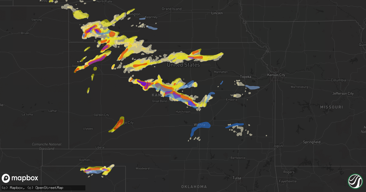
Hail Map in Kansas on May 26, 2021
Get this storm
May 26 map
$229
one time, instant access
Download today. No call, no setup
Keep the $229
Bought the map and want the full workflow? Apply the entire $229 to a subscription within 7 days. None of it is wasted.
Every map, not just this one
This buys you this map. Subscription and you get every map we run, in the markets you choose from a few cities to whole states to nationwide. Plus real-time alerts the moment a storm fires.
Contact data
Name, contact info, occupancy, even credit band for addresses in the footprint. You go from where it hit to who to call.
Become the source they trust
Unlimited branding weather history reports on demand. You already have the documented answer ready for the property owner, and you are the one who showed up with it.
Property data and RoofTrace estimates
Pull up any address you have got, its value and the exact code rules for that jurisdiction, straight from One Click Code. Then RoofTrace estimates the squares, pitch, and roof value, priced the way you price.
Storm reports in Kansas
Kansas
| Date | Description |
|---|---|
| 05/26/20216:57 PM CDT | A local report indicates 1.75 inch wind near 4 SW GENESEO |
| 05/26/20216:56 PM CDT | A local report indicates 60 MPH wind near 2 SW SALINA |
| 05/26/20216:56 PM CDT | A local report indicates 1.75 inch wind near FREDERICK |
| 05/26/20216:54 PM CDT | A local report indicates 1.25 inch wind near WNW GENESEO |
| 05/26/20216:54 PM CDT | Very heavy rain with the hail. |
| 05/26/20216:49 PM CDT | Delayed report...tornado hit a homestead causing damage to an older barn... Trees... And a utility shed. Winds were estimated at 85 mph. |
| 05/26/20216:43 PM CDT | A local report indicates 1.00 inch wind near FREDERICK |
| 05/26/20216:42 PM CDT | Spotter report of brief tornado touching down. Funnel clouds remain seen in the area with rapid rotation. |
| 05/26/20216:35 PM CDT | Semi truck blown over on hwy 156. |
| 05/26/20216:24 PM CDT | A local report indicates 1.50 inch wind near HOLYROOD |
| 05/26/20216:20 PM CDT | Delayed reports of power pole and tree damage in and around beloit. |
| 05/26/20216:12 PM CDT | Hail ranged from penny to quarter with occasional golf ball. |
| 05/26/20216:08 PM CDT | Report from mping: quarter sized hail reported. |
| 05/26/20216:05 PM CDT | 1.3 inches of rain and 40 mph winds with the storm as it passed. |
| 05/26/20216:05 PM CDT | Kansas mesonet wind gust in stratiform rain on north side of thunderstorms. |
| 05/26/20216:00 PM CDT | A local report indicates 1.00 inch wind near KANOPOLIS STATE PARK |
| 05/26/20215:59 PM CDT | Pws station kksglene3. In stratiform precip on north side of thunderstorms. |
| 05/26/20215:50 PM CDT | Possible tornado reported at cr dd and cr 22. |
| 05/26/20215:49 PM CDT | A local report indicates 1.75 inch wind near 6 N HERNDON |
| 05/26/20215:47 PM CDT | A local report indicates a tornado near 4 NE HERNDON |
| 05/26/20215:40 PM CDT | Another tornado reported just west of the first one. New tornado located roughly at cr 32 and cr y or z. |
| 05/26/20215:38 PM CDT | Tornado was on the ground at time of call. |
| 05/26/20215:33 PM CDT | A local report indicates 1.00 inch wind near WINONA |
| 05/26/20215:31 PM CDT | A local report indicates 1.00 inch wind near 3 ESE WINONA |
| 05/26/20215:30 PM CDT | Corrects previous tornado report from 7 nw herndon. Tornado reported at cr y and cr 30. First responders report homestead struck in the area. |
| 05/26/20215:29 PM CDT | A tornado hit a farmstead northwest of herndon. At the farmstead... Damage consisted of numerous snapped and uprooted trees... Several farm structures damaged including |
| 05/26/20215:20 PM CDT | Spotter reported possible tornado roughly 5 miles north of atwood. |
| 05/26/20215:19 PM CDT | Off duty nws employee reports tornado near herndon. Was looking west in between oberlin and mccook. |
| 05/26/20215:10 PM CDT | Brief touchdown for less than one minute. |
| 05/26/20214:54 PM CDT | Very brief touchdown. |
| 05/26/20214:52 PM CDT | Report received of quarter sized hail north of leoti. |
| 05/26/20214:49 PM CDT | Report from mping: half dollar |
| 05/26/20214:45 PM CDT | Via social media pic. |
| 05/26/20214:39 PM CDT | A local report indicates 1.50 inch wind near RUSSELL |
| 05/26/20214:35 PM CDT | Delayed report. |
| 05/26/20214:28 PM CDT | Dime sized hail also reported along with very heavy rain. |
| 05/26/20214:25 PM CDT | 40 foot tall... 3ft wide elm tree blown over. Delayed report. Time estimated based on radar. |
| 05/26/20214:24 PM CDT | 60 mph winds were also reported along with an uprooted tree. |
| 05/26/20214:06 PM CDT | A local report indicates 60 MPH wind near 2 SE GORHAM |
| 05/26/20214:04 PM CDT | 60 to 70 mph winds. |
| 05/26/20213:50 PM CDT | A local report indicates 1.00 inch wind near 3 S GORHAM |
| 05/26/20213:30 PM CDT | Report from mping: half dollar |
| 05/26/20213:30 PM CDT | A local report indicates 1.00 inch wind near SCHOENCHEN |
| 05/26/20213:25 PM CDT | A local report indicates a tornado near 3 NW PFEIFER |
| 05/26/20213:23 PM CDT | Report from mping: hen egg |
| 05/26/20213:22 PM CDT | Multiple spotters reporting a tornado. |
| 05/26/20213:03 PM CDT | Numerous reports of a tornado from spotters and confirmed on video. |
| 05/26/20212:58 PM CDT | A local report indicates a tornado near 2 N SCHOENCHEN |
| 05/26/20212:56 PM CDT | A local report indicates 1.75 inch wind near 1 SE HAYS |
| 05/26/20212:49 PM CDT | Report from mping: quarter |
| 05/26/20212:41 PM CDT | A local report indicates 1.75 inch wind near TOULON |
| 05/26/20212:41 PM CDT | A local report indicates 1.00 inch wind near MUNJOR |
| 05/26/20212:39 PM CDT | Report from mping: quarter |
| 05/26/20212:30 PM CDT | Delayed report...largest hail stone size with average size 2.5 inches. |
| 05/26/20212:30 PM CDT | Social media post. |
| 05/26/20212:13 PM CDT | A local report indicates 1.75 inch wind near 1 SSW HAYS |
| 05/26/20212:13 PM CDT | Report from mping: hen egg |
| 05/26/20212:11 PM CDT | Report from mping: quarter |
| 05/26/20212:08 PM CDT | A local report indicates 2.75 inch wind near HAYS |
| 05/26/20212:06 PM CDT | Report from mping: quarter |
| 05/26/20212:04 PM CDT | A local report indicates 1.00 inch wind near 2 ENE YOCEMENTO |
| 05/26/20212:00 PM CDT | Report from mping: half dollar |
| 05/26/20211:49 PM CDT | A local report indicates 1.50 inch wind near ELLIS |
| 05/26/20211:40 PM CDT | A local report indicates 2.25 inch wind near ELLIS |
| 05/26/20211:37 PM CDT | A local report indicates 1.75 inch wind near 1 N ELLIS |
| 05/26/20211:36 PM CDT | A local report indicates 1.25 inch wind near 1 N ELLIS |
| 05/26/20211:28 PM CDT | A local report indicates 1.50 inch wind near ELLIS |
| 05/26/20211:25 PM CDT | A local report indicates 1.00 inch wind near ELLIS |
| 05/26/20211:15 PM CDT | Delayed report. |
| 05/26/20211:13 PM CDT | A local report indicates 1.00 inch wind near 1 SE WAKEENEY |
| 05/26/202111:52 AM CDT | Storm chaser reported golf ball to tennis ball size hail. Hail broke their windshield. |
| 05/26/202111:37 AM CDT | Penny to quarter size hail covering the ground. |
| 05/26/202111:08 AM CDT | A local report indicates 1.50 inch wind near BREWSTER |
| 05/26/202111:08 AM CDT | Corrects previous hail report from 2 s brewster. |
| 05/26/202110:30 AM CDT | A local report indicates 1.00 inch wind near 2 SSW GOODLAND |
| 05/26/202110:29 AM CDT | Report from mping: quarter |
| 05/26/202110:26 AM CDT | A local report indicates 1.00 inch wind near 7 SSE GOODLAND |
| 05/26/202110:18 AM CDT | Delayed report. |
| 05/26/202110:12 AM CDT | Delayed report. |
| 05/26/202110:06 AM CDT | A local report indicates 1.25 inch wind near 10 NNW BREWSTER |
| 05/26/20217:42 AM CDT | At 1242 PM CDT, a severe thunderstorm was located near Trego Center, moving northeast at 20 mph. HAZARD...60 mph wind gusts and half dollar size hail. SOURCE...Radar indicated. IMPACT...Hail damage to vehicles is expected. Expect wind damage to roofs, siding, and trees. This severe thunderstorm will be near... Wakeeney around 1255 PM CDT. Ogallah around 100 PM CDT. |
| 05/26/20217:22 AM CDT | At 1221 PM CDT, a severe thunderstorm was located 10 miles northwest of Rexford, or 15 miles northeast of Colby, moving northeast at 25 mph. HAZARD...Tennis ball size hail and 60 mph wind gusts. SOURCE...Trained weather spotters. At 1152 AM CDT...tennis ball size hail was reported 10 miles north of Colby. IMPACT...People and animals outdoors will be injured. Expect hail damage to roofs, siding, windows, and vehicles. Expect wind damage to roofs, siding, and trees. Locations impacted include... Dresden, Oberlin and Jennings. |
| 05/26/20216:53 AM CDT | At 1153 PM CDT, severe thunderstorms were located along a line extending from near Ionia to near Cawker City, moving east at 45 mph. HAZARD...60 mph wind gusts and quarter size hail. SOURCE...Radar indicated. IMPACT...Hail damage to vehicles is expected. Expect wind damage to roofs, siding, and trees. Severe thunderstorms will be near... Glen Elder around 1200 AM CDT. Mankato and Jewell around 1210 AM CDT.Other locations in the path of these severe thunderstorms includeBeloit, Randall, Montrose, Formoso and Scottsville. |
| 05/26/20216:35 AM CDT | At 1135 PM CDT, a severe thunderstorm was located near Viola, or near Conway Springs, moving northeast at 25 mph. This storm produced a 56 mph measured wind gust near Viola. HAZARD...60 mph wind gusts. SOURCE...Radar indicated. IMPACT...Expect damage to roofs, siding, and trees. This severe thunderstorm will be near... Clearwater around 1155 PM CDT.Other locations in the path of this severe thunderstorm includeGoddard and Eisenhower National Airport. |
| 05/26/20216:34 AM CDT | At 1133 AM CDT, a severe thunderstorm was located 5 miles north of Levant, moving northeast at 25 mph. HAZARD...Two inch hail and 60 mph wind gusts. SOURCE...Radar indicated. At 1106 AM CDT...ping pong ball size hail occurred in Brewster. IMPACT...People and animals outdoors will be injured. Expect hail damage to roofs, siding, windows, and vehicles. Expect wind damage to roofs, siding, and trees. This severe thunderstorm will be near... Colby around 1140 AM CDT. |
| 05/26/20216:24 AM CDT | At 1123 PM CDT, severe thunderstorms were located along a line extending from 4 miles northeast of Wakita to 7 miles northwest of Jefferson to 5 miles northeast of Hillsdale, moving east at 45 mph. HAZARD...60 mph wind gusts and penny size hail. SOURCE...Radar indicated. IMPACT...Expect damage to roofs, siding, and trees. Locations impacted include... Medford, Pond Creek, Lamont, Wakita, Braman, Nash, Deer Creek, Manchester, Jefferson, Renfrow, Nardin and Blackwell Lake. |
| 05/26/20216:04 AM CDT | At 1104 PM CDT, severe thunderstorms were located along a line extending from near Athol to near Alton to 8 miles southeast of Woodston, moving east at 45 mph. HAZARD...60 mph wind gusts and quarter size hail. SOURCE...Radar indicated. IMPACT...Hail damage to vehicles is expected. Expect wind damage to roofs, siding, and trees. Severe thunderstorms will be near... Gaylord around 1110 PM CDT. Smith Center and Harlan around 1115 PM CDT. Portis and Bellaire around 1120 PM CDT.Other locations in the path of these severe thunderstorms includeOsborne, Downs and Lebanon. |
| 05/26/20215:55 AM CDT | At 1055 PM CDT, a severe thunderstorm was located near Goessel, or 9 miles west of Peabody, moving northeast at 25 mph. HAZARD...60 mph wind gusts and quarter size hail. SOURCE...Radar indicated. IMPACT...Hail damage to vehicles is expected. Expect wind damage to roofs, siding, and trees. Locations impacted include... Hillsboro and Marion. |
| 05/26/20215:40 AM CDT | At 1038 PM CDT, severe thunderstorms were located along a line extending from 7 miles south of Kirwin to near Stockton to near Webster State Park, moving east at 35 mph. HAZARD...Ping pong ball size hail and 60 mph wind gusts. SOURCE...Radar indicated. IMPACT...People and animals outdoors will be injured. Expect hail damage to roofs, siding, windows, and vehicles. Expect wind damage to roofs, siding, and trees. Severe thunderstorms will be near... Kirwin around 1045 PM CDT. Woodston around 1050 PM CDT.Other locations in the path of these severe thunderstorms includeCedar and Alton.Radar indicates that the greatest threat for large hail is currently centered in the Webster State Park and Stockton areas. |
| 05/26/20215:14 AM CDT | At 1014 AM MDT/1114 AM CDT/, a severe thunderstorm was located 4 miles west of McDonald, or 17 miles south of Benkelman, moving northeast at 30 mph. HAZARD...Quarter size hail. SOURCE...Radar indicated. IMPACT...Damage to vehicles is expected. Locations impacted include... Stratton and Trenton. |
| 05/26/20215:08 AM CDT | At 1008 PM CDT, severe thunderstorms were located along a line extending from 9 miles south of Logan to Damar, moving east at 20 mph. HAZARD...60 mph wind gusts and quarter size hail. SOURCE...Radar indicated. IMPACT...Hail damage to vehicles is expected. Expect wind damage to roofs, siding, and trees. Locations impacted include... Zurich and Webster State Park. |
| 05/26/20215:00 AM CDT | At 1000 PM CDT, a severe thunderstorm was located near Nicodemus, or 11 miles east of Hill City, moving east at 30 mph. HAZARD...60 mph wind gusts and half dollar size hail. SOURCE...Radar indicated. IMPACT...Hail damage to vehicles is expected. Expect wind damage to roofs, siding, and trees. This severe thunderstorm will remain over mainly rural areas of northeastern Graham County. |
| 05/26/20215:00 AM CDT | At 959 PM CDT, a severe thunderstorm was located 5 miles west of Goessel, or 6 miles north of Hesston, moving southeast at 15 mph. HAZARD...Golf ball size hail and 60 mph wind gusts. SOURCE...Radar indicated. IMPACT...People and animals outdoors will be injured. Expect hail damage to roofs, siding, windows, and vehicles. Expect wind damage to roofs, siding, and trees. This severe thunderstorm will be near... Goessel around 1005 PM CDT.This includes Interstate 135 between Mile Markers 38 and 55. |
| 05/26/20214:42 AM CDT | At 942 AM MDT/1042 AM CDT/, a severe thunderstorm was located 7 miles east of Goodland, moving northeast at 15 mph. HAZARD...Ping pong ball size hail. SOURCE...Radar indicated. IMPACT...People and animals outdoors will be injured. Expect damage to roofs, siding, windows, and vehicles. Locations impacted include... Brewster and Levant.This includes Interstate 70 in Kansas between mile markers 20 and 50. |
| 05/26/20214:38 AM CDT | At 938 PM CDT, a severe thunderstorm was located near Lebanon, or 19 miles east of McCook, moving east at 30 mph. HAZARD...60 mph wind gusts and quarter size hail. SOURCE...Radar indicated. IMPACT...Hail damage to vehicles is expected. Expect wind damage to roofs, siding, and trees. This severe thunderstorm will remain over mainly rural areas of southeastern Red Willow County. |
| 05/26/20214:31 AM CDT | At 931 PM CDT, severe thunderstorms were located along a line extending from Bartley to near Lebanon, moving east at 50 mph. HAZARD...60 mph wind gusts and quarter size hail. SOURCE...Radar indicated. IMPACT...Hail damage to vehicles is expected. Expect wind damage to roofs, siding, and trees. Severe thunderstorms will be near... Cambridge and Wilsonville around 940 PM CDT. Holbrook and Hendley around 950 PM CDT.Other locations in the path of these severe thunderstorms includeArapahoe, Beaver City, Edison and Hollinger. |
| 05/26/20214:31 AM CDT | At 930 PM CDT, a severe thunderstorm was located near Hill City, moving east at 20 mph. HAZARD...60 mph wind gusts and quarter size hail. SOURCE...Radar indicated. IMPACT...Hail damage to vehicles is expected. Expect wind damage to roofs, siding, and trees. This severe thunderstorm will be near... Hill City around 945 PM CDT.Other locations in the path of this severe thunderstorm includeBogue. |
| 05/26/20214:28 AM CDT | At 927 PM CDT, a severe thunderstorm was located near Palco, or 17 miles southeast of Hill City, moving east at 30 mph. HAZARD...Ping pong ball size hail and 60 mph wind gusts. SOURCE...Radar indicated. IMPACT...People and animals outdoors will be injured. Expect hail damage to roofs, siding, windows, and vehicles. Expect wind damage to roofs, siding, and trees. This severe thunderstorm will be near... Zurich around 940 PM CDT. Webster State Park around 945 PM CDT.Other locations in the path of this severe thunderstorm includeStockton and Plainville. |
| 05/26/20214:16 AM CDT | At 916 PM CDT, severe thunderstorms were located along a line extending from 4 miles northeast of Avard to 10 miles north of Freedom to 6 miles southeast of Selman, moving east at 45 mph. HAZARD...70 mph wind gusts and nickel size hail. SOURCE...Radar indicated. IMPACT...Expect considerable tree damage. Damage is likely to mobile homes, roofs, and outbuildings. Locations impacted include... Alva, Buffalo, Waynoka, Freedom, Dacoma, Alabaster Caverns State Park, Selman, Avard, Capron, Hopeton and Camp Houston. |
| 05/26/20214:15 AM CDT | At 914 PM CDT, severe thunderstorms were located along a line extending from near Galva to Moundridge to near Buhler, moving southeast at 20 mph. HAZARD...Golf ball size hail and 70 mph wind gusts. SOURCE...Radar indicated. IMPACT...People and animals outdoors will be injured. Expect hail damage to roofs, siding, windows, and vehicles. Expect considerable tree damage. Wind damage is also likely to mobile homes, roofs, and outbuildings. Severe thunderstorms will be near... Moundridge around 920 PM CDT. Hesston around 930 PM CDT.Other locations in the path of these severe thunderstorms includeBurrton and Goessel.This includes Interstate 135 between Mile Markers 35 and 64.This replaces the severe thunderstorm warnings previously in effectfor McPherson county. |
| 05/26/20214:09 AM CDT | At 907 AM MDT/1007 AM CDT/, a severe thunderstorm was located 13 miles northwest of Brewster, moving northeast at 40 mph. HAZARD...60 mph wind gusts and half dollar size hail. SOURCE...Trained weather spotters. At 907 AM MDT...half dollar size hail was reported 10 miles north northwest of Brewster. IMPACT...Hail damage to vehicles is expected. Expect wind damage to roofs, siding, and trees. Locations impacted include... McDonald. |
| 05/26/20214:02 AM CDT | At 901 PM CDT, a severe thunderstorm was located over Lebanon, or 20 miles northeast of Oberlin, moving northeast at 25 mph. HAZARD...Quarter size hail. SOURCE...Radar indicated. IMPACT...Damage to vehicles is expected. This severe thunderstorm will remain over mainly rural areas of southeastern Red Willow County. |
| 05/26/20213:57 AM CDT | At 856 PM CDT, a severe thunderstorm was located just north of Inman, moving east-southeast at 10 mph. HAZARD...Ping pong ball size hail and 60 mph wind gusts. SOURCE...Radar indicated. IMPACT...People and animals outdoors will be injured. Expect hail damage to roofs, siding, windows, and vehicles. Expect wind damage to roofs, siding, and trees. Locations impacted include... Moundridge.This includes Interstate 135 between Mile Markers 43 and 53. |
| 05/26/20213:53 AM CDT | At 853 PM CDT, a severe thunderstorm was located near Hill City, moving northeast at 20 mph. HAZARD...60 mph wind gusts and half dollar size hail. SOURCE...Radar indicated. IMPACT...Hail damage to vehicles is expected. Expect wind damage to roofs, siding, and trees. This severe thunderstorm will be near... Hill City around 905 PM CDT.Other locations in the path of this severe thunderstorm includeBogue. |
| 05/26/20213:38 AM CDT | At 838 AM MDT/938 AM CDT/, a severe thunderstorm was located 11 miles south of Ruleton, moving northeast at 30 mph. HAZARD...60 mph wind gusts and half dollar size hail. SOURCE...Radar indicated. IMPACT...Hail damage to vehicles is expected. Expect wind damage to roofs, siding, and trees. Locations impacted include... Goodland and Brewster.This includes Interstate 70 in Kansas between mile markers 16 and 37. |
| 05/26/20213:28 AM CDT | At 827 PM CDT, a severe thunderstorm was located just west of Mcpherson, moving east at 20 mph. HAZARD...60 mph wind gusts and quarter size hail. SOURCE...Radar indicated. IMPACT...Hail damage to vehicles is expected. Expect wind damage to roofs, siding, and trees. This severe thunderstorm will be near... Mcpherson around 840 PM CDT.Other locations in the path of this severe thunderstorm include Galvaand Canton.This includes Interstate 135 between Mile Markers 53 and 73. |
| 05/26/20213:24 AM CDT | At 824 PM CDT, a severe thunderstorm was located 4 miles southwest of Norton, moving northeast at 25 mph. HAZARD...60 mph wind gusts and quarter size hail. SOURCE...Radar indicated. IMPACT...Hail damage to vehicles is expected. Expect wind damage to roofs, siding, and trees. This severe thunderstorm will be near... Norton around 835 PM CDT.Other locations in the path of this severe thunderstorm includeAlmena. |
| 05/26/20213:00 AM CDT | Trees down... Time estimated. |
| 05/26/20212:58 AM CDT | At 758 PM CDT, a severe thunderstorm was located near Little River, or 14 miles northeast of Lyons, moving east at 15 mph. HAZARD...60 mph wind gusts and half dollar size hail. SOURCE...Radar indicated. IMPACT...Hail damage to vehicles is expected. Expect wind damage to roofs, siding, and trees. This severe thunderstorm will be near... Windom around 810 PM CDT. |
| 05/26/20212:30 AM CDT | At 730 PM CDT, a severe thunderstorm was located near Ensign, moving northeast at 25 mph. HAZARD...Golf ball size hail and 60 mph wind gusts. SOURCE...Radar indicated. IMPACT...People and animals outdoors will be injured. Expect hail damage to roofs, siding, windows, and vehicles. Expect wind damage to roofs, siding, and trees. Locations impacted include... Dodge City, Ford, Ensign, Wright, Ft. Dodge and Howell. |
| 05/26/20212:22 AM CDT | A local report indicates 1.00 inch wind near 5 NE MORGANVILLE |
| 05/26/20212:20 AM CDT | At 718 PM CDT, a severe thunderstorm was located near Danbury, or 14 miles southeast of McCook, moving east at 25 mph. HAZARD...60 mph wind gusts and quarter size hail. SOURCE...Radar indicated. IMPACT...Hail damage to vehicles is expected. Expect wind damage to roofs, siding, and trees. Locations impacted include... Wilsonville and Hendley.Radar indicates some rotation with this storm near Danbury in Red Willow County, but it is currently unclear whether any organized rotation will reach Furnas County. |
| 05/26/20212:15 AM CDT | At 714 PM CDT, severe thunderstorms were located along a line extending from 12 miles west of Marquette to near Geneseo to Chase, moving east at 25 mph. HAZARD...60 mph wind gusts and half dollar size hail. SOURCE...Radar indicated. IMPACT...Hail damage to vehicles is expected. Expect wind damage to roofs, siding, and trees. Severe thunderstorms will be near... Little River around 730 PM CDT.Other locations in the path of these severe thunderstorms includeMarquette and Windom.This replaces the tornado warning previously in effect. |
| 05/26/20212:15 AM CDT | Downed power line... Time approximated. |
| 05/26/20212:06 AM CDT | At 706 PM CDT, a severe thunderstorm was located 7 miles south of Copeland, moving northeast at 30 mph. HAZARD...Quarter size hail. SOURCE...Radar indicated. IMPACT...Damage to vehicles is expected. This severe thunderstorm will be near... Copeland around 715 PM CDT.Other locations in the path of this severe thunderstorm includeMontezuma, The Haggard Elev and Ensign. |
| 05/26/20212:00 AM CDT | Downed tree limbs... Time approximated. |
| 05/26/20211:59 AM CDT | At 659 PM CDT, a severe thunderstorm was located near Brookville, or 10 miles southwest of Salina, moving northeast at 20 mph. Another severe storm was over Salina. HAZARD...60 mph wind gusts and nickel size hail. SOURCE...Radar indicated. IMPACT...Expect damage to roofs, siding, and trees. This severe thunderstorm will be near... Salina and Smolan around 715 PM CDT.Other locations in the path of this severe thunderstorm include NewCambria.This includes the following highways... Interstate 135 between Mile Markers 84 and 95. Interstate 70 between Mile Markers 237 and 266. |
| 05/26/20211:55 AM CDT | At 654 PM CDT, a severe thunderstorm was located near Hoxie, moving northeast at 30 mph. HAZARD...60 mph wind gusts and quarter size hail. SOURCE...Radar indicated. IMPACT...Hail damage to vehicles is expected. Expect wind damage to roofs, siding, and trees. This severe thunderstorm will remain over mainly rural areas of northeastern Sheridan County, including the following locations... Tasco. |
| 05/26/20211:38 AM CDT | Asos station kcnk concordia. |
| 05/26/20211:33 AM CDT | 1-inch tree limbs broken; shingles blown off. |
| 05/26/20211:30 AM CDT | At 630 PM CDT, a severe thunderstorm was located just north of Holyrood, or 8 miles northeast of Claflin, moving east at 20 mph. HAZARD...Ping pong ball size hail and 60 mph wind gusts. SOURCE...Radar indicated. IMPACT...People and animals outdoors will be injured. Expect hail damage to roofs, siding, windows, and vehicles. Expect wind damage to roofs, siding, and trees. Locations impacted include... Ellsworth. |
| 05/26/20211:25 AM CDT | Mesonet station fw6911 manhattan. |
| 05/26/20211:13 AM CDT | Reported at manhattan regional airport asos. |
| 05/26/20211:10 AM CDT | Tree uprooted near bluemont elementary school time estimated. |
| 05/26/20211:06 AM CDT | At 606 PM CDT, a severe thunderstorm was located 7 miles northeast of Kanopolis, moving east at 30 mph. HAZARD...60 mph wind gusts and quarter size hail. SOURCE...Radar indicated. IMPACT...Hail damage to vehicles is expected. Expect wind damage to roofs, siding, and trees. This severe thunderstorm will be near... Brookville around 625 PM CDT.Other locations in the path of this severe thunderstorm includeSalina and Smolan.This includes the following highways... Interstate 135 between Mile Markers 77 and 95. Interstate 70 between Mile Markers 236 and 258. |
| 05/26/20211:02 AM CDT | At 602 PM CDT, a severe thunderstorm was located over Claflin, moving northeast at 15 mph. HAZARD...60 mph wind gusts and quarter size hail. SOURCE...Radar indicated. IMPACT...Hail damage to vehicles is expected. Expect wind damage to roofs, siding, and trees. Locations impacted include... Holyrood and Lorraine. |
| 05/26/202112:55 AM CDT | 6-inch tree limbs down... E60. |
| 05/26/202112:54 AM CDT | Delayed report via twitter with photos. Time estimated from radar. At least 8 power poles snapped. Tree with 18 to 24 inch diameter snapped at base. |
| 05/26/202112:50 AM CDT | Delayed report: very large tree |
| 05/26/202112:44 AM CDT | At 543 PM CDT, a severe thunderstorm was located over Ellsworth, moving east at 20 mph. Another severe storm was located 5 miles south of Lincoln...moving northeast at 15 mph. HAZARD...Golf ball size hail and 70 mph wind gusts. SOURCE...Radar indicated. IMPACT...People and animals outdoors will be injured. Expect hail damage to roofs, siding, windows, and vehicles. Expect considerable tree damage. Wind damage is also likely to mobile homes, roofs, and outbuildings. This severe thunderstorm will be near... Kanopolis around 555 PM CDT.This includes Interstate 70 between Mile Markers 213 and 235.This warning replaces the tornado warning that was in effect for Ellsworth county. |
| 05/26/202112:42 AM CDT | At 542 PM CDT, a severe thunderstorm was located over Russell Springs, or 21 miles northwest of Scott State Lake, moving north at 45 mph. HAZARD...60 mph wind gusts and quarter size hail. SOURCE...Radar indicated. IMPACT...Hail damage to vehicles is expected. Expect wind damage to roofs, siding, and trees. This severe thunderstorm will be near... Winona around 555 PM CDT. Monument around 600 PM CDT. |
| 05/26/202112:40 AM CDT | A local report indicates 58 MPH wind near MCCONNELL AFB |
| 05/26/202112:34 AM CDT | At 534 PM CDT, a severe thunderstorm was located 6 miles southeast of Milberger, or 11 miles north of Hoisington, moving northeast at 25 mph. HAZARD...60 mph wind gusts and quarter size hail. SOURCE...Radar indicated. IMPACT...Hail damage to vehicles is expected. Expect wind damage to roofs, siding, and trees. Locations impacted include... Dorrance.This includes Interstate 70 between Mile Markers 186 and 204. |
| 05/26/202112:33 AM CDT | At 533 PM CDT, a severe thunderstorm was located 4 miles east of Winona, or 16 miles west of Oakley, moving north at 50 mph. HAZARD...60 mph wind gusts and quarter size hail. SOURCE...Trained weather spotters. IMPACT...Hail damage to vehicles is expected. Expect wind damage to roofs, siding, and trees. Locations impacted include... Colby and Levant.This includes Interstate 70 in Kansas between mile markers 43 and 65. |
| 05/26/202112:31 AM CDT | 1-inch tree limbs broken; shingles blown off. |
| 05/26/202112:25 AM CDT | Delayed report: 12-14 live tree snapped near the base. |
| 05/26/202112:24 AM CDT | A local report indicates 69 MPH wind near JABARA AIRPORT |
| 05/26/202112:20 AM CDT | Delayed report: trees across roads and wind damage to homes. |
| 05/26/202112:15 AM CDT | A local report indicates 60 MPH wind near 1 N EAST WICHITA |
| 05/26/202112:14 AM CDT | Ground is white with hail and many leaves stripped. |
| 05/26/202112:08 AM CDT | Delayed report: large tree down over the road. |
| 05/26/202112:04 AM CDT | A local report indicates 58 MPH wind near WICHITA EISENHOWER NATI |
| 05/26/202112:03 AM CDT | A local report indicates 60 MPH wind near MCCONNELL AFB |
| 05/26/202112:01 AM CDT | Delayed report: numerous large tree limbs down. |
| 05/26/202112:00 AM CDT | A local report indicates 58 MPH wind near 5 NE WICHITA EISENHOWER |
| 05/25/202111:58 PM CDT | At 457 PM CDT, a severe thunderstorm was located near Dorrance, or 9 miles west of Wilson, moving east at 25 mph. Another severe storm was located on I-70 in north central Ellsworth county...moving north-northeast at 15 mph. HAZARD...70 mph wind gusts and half dollar size hail. SOURCE...Radar indicated. IMPACT...Hail damage to vehicles is expected. Expect considerable tree damage. Wind damage is also likely to mobile homes, roofs, and outbuildings. This severe thunderstorm will be near... Dorrance around 505 PM CDT.Other locations in the path of this severe thunderstorm includeWilson and Ellsworth.This includes Interstate 70 between Mile Markers 192 and 226. |
| 05/25/202111:56 PM CDT | At 456 PM CDT, a severe thunderstorm was located 14 miles north of Leoti, moving north at 35 mph. HAZARD...60 mph wind gusts and half dollar size hail. SOURCE...Public. IMPACT...Hail damage to vehicles is expected. Expect wind damage to roofs, siding, and trees. Locations impacted include... Russell Springs. |
| 05/25/202111:40 PM CDT | A local report indicates 62 MPH wind near 5 NW CLEARWATER |
| 05/25/202111:28 PM CDT | At 428 PM CDT, a severe thunderstorm was located 6 miles west of Ellsworth, moving east-northeast at 20 mph. HAZARD...70 mph wind gusts and half dollar size hail. SOURCE...Radar indicated. IMPACT...Hail damage to vehicles is expected. Expect considerable tree damage. Wind damage is also likely to mobile homes, roofs, and outbuildings. This severe thunderstorm will be near... Ellsworth around 445 PM CDT.Other locations in the path of this severe thunderstorm includeKanopolis.This includes Interstate 70 between Mile Markers 206 and 225. |
| 05/25/202110:57 PM CDT | At 357 PM CDT, a severe thunderstorm was located near Walker, moving east at 15 mph. HAZARD...70 mph wind gusts and half dollar size hail. SOURCE...Radar indicated. IMPACT...Hail damage to vehicles is expected. Expect considerable tree damage. Wind damage is also likely to mobile homes, roofs, and outbuildings. This severe thunderstorm will be near... Gorham around 405 PM CDT.Other locations in the path of this severe thunderstorm includeMilberger and Russell.This includes Interstate 70 between Mile Markers 175 and 197. |
| 05/25/202110:56 PM CDT | Asos station kp28 medicine lodge. |
| 05/25/202110:49 PM CDT | At 348 PM CDT, a severe thunderstorm was located 8 miles northwest of Holyrood, or 10 miles north of Claflin, moving northeast at 20 mph. HAZARD...60 mph wind gusts and half dollar size hail. SOURCE...Radar indicated. IMPACT...Hail damage to vehicles is expected. Expect wind damage to roofs, siding, and trees. Locations impacted include... Wilson.This includes Interstate 70 between Mile Markers 198 and 214. |
| 05/25/202110:46 PM CDT | At 345 PM CDT, a severe thunderstorm was located just south of Waldo, or 14 miles north of Russell, moving north at 35 mph. HAZARD...Ping pong ball size hail and 60 mph wind gusts. SOURCE...Radar indicated. IMPACT...People and animals outdoors will be injured. Expect hail damage to roofs, siding, windows, and vehicles. Expect wind damage to roofs, siding, and trees. This severe thunderstorm will remain over mainly rural areas of southwestern and south central Osborne County. |
| 05/25/202110:46 PM CDT | Via twitter. |
| 05/25/202110:27 PM CDT | At 326 PM CDT, a severe thunderstorm was located near Schoenchen, moving northeast at 10 mph. HAZARD...Golf ball size hail. SOURCE...Radar indicated. IMPACT...People and animals outdoors will be injured. Expect damage to roofs, siding, windows, and vehicles. Locations impacted include... Hays, Schoenchen, Liebenthal, Loretta, Pfeifer, Munjor, Antonino and Toulon. |
| 05/25/202110:24 PM CDT | A local report indicates 1.00 inch wind near WEBSTER STATE PARK |
| 05/25/202110:24 PM CDT | At 324 PM CDT, severe thunderstorms were located along a line extending from near Russell to Milberger, moving east at 15 mph. HAZARD...Ping pong ball size hail. SOURCE...Radar indicated. IMPACT...People and animals outdoors will be injured. Expect damage to roofs, siding, windows, and vehicles. Locations impacted include... Russell, Gorham, Milberger and Russell Airport. This includes Interstate 70 between Mile Markers 175 and 187. |
| 05/25/202110:18 PM CDT | At 318 PM CDT, a severe thunderstorm was located very near Victoria, moving east at 10 mph. HAZARD...Two inch hail. SOURCE...Radar indicated. IMPACT...People and animals outdoors will be injured. Expect damage to roofs, siding, windows, and vehicles. This severe thunderstorm will be near... Victoria around 325 PM CDT.Other locations in the path of this severe thunderstorm includeWalker. |
| 05/25/202110:17 PM CDT | At 317 PM CDT, a severe thunderstorm was located 7 miles west of Dorrance, or 7 miles east of Russell, moving north at 30 mph. HAZARD...Ping pong ball size hail. SOURCE...Radar indicated. IMPACT...People and animals outdoors will be injured. Expect damage to roofs, siding, windows, and vehicles. Locations impacted include... Lucas, Luray, Waldo, Wilson Lake and Wilson State Park. |
| 05/25/202110:15 PM CDT | Time estimated from radar. |
| 05/25/202110:05 PM CDT | At 305 PM MDT/405 PM CDT/, a severe thunderstorm was located over Benkelman, moving northeast at 30 mph. HAZARD...60 mph wind gusts and quarter size hail. SOURCE...Radar indicated. IMPACT...Hail damage to vehicles is expected. Expect wind damage to roofs, siding, and trees. Locations impacted include... Stratton and Palisade. |
| 05/25/202110:00 PM CDT | A local report indicates 1.00 inch wind near BOGUE |
| 05/25/20219:46 PM CDT | At 246 PM CDT, a severe thunderstorm was located 9 miles northeast of Hoisington, moving north at 30 mph. HAZARD...Golf ball size hail. SOURCE...Radar indicated. IMPACT...People and animals outdoors will be injured. Expect damage to roofs, siding, windows, and vehicles. Locations impacted include... Claflin, Dorrance, Bunker Hill, Susank and Odin. This includes Interstate 70 between Mile Markers 188 and 204. |
| 05/25/20219:44 PM CDT | A local report indicates 1.00 inch wind near HILL CITY |
| 05/25/20219:38 PM CDT | At 237 PM CDT, a severe thunderstorm was located very near Munjor, moving southeast at 10 mph. This is a very dangerous storm. HAZARD...Three inch hail. SOURCE...Radar indicated. IMPACT...People and animals outdoors will be severely injured. Expect shattered windows, extensive damage to roofs, siding, and vehicles. Locations impacted include... Victoria, Pfeifer and Loretta. |
| 05/25/20219:30 PM CDT | Also reported dime size hail. |
| 05/25/20219:20 PM CDT | A local report indicates 1.25 inch wind near 3 W GALVA |
| 05/25/20219:07 PM CDT | Brief tornado with small ground circulations reported at this location. |
| 05/25/20219:07 PM CDT | A local report indicates 1.00 inch wind near INMAN |
| 05/25/20219:00 PM CDT | A quarter to half the shingles on a roof peeled off by the wind. Estimated time of report from radar. |
| 05/25/20218:53 PM CDT | At 152 PM CDT, a severe thunderstorm was located near Yocemento, moving southeast at 10 mph. This is a very dangerous storm. HAZARD...Three inch hail. SOURCE...Radar indicated. IMPACT...People and animals outdoors will be severely injured. Expect shattered windows, extensive damage to roofs, siding, and vehicles. This severe thunderstorm will be near... Yocemento around 200 PM CDT.Other locations in the path of this severe thunderstorm includeAntonino, Hays, Schoenchen, Munjor and Toulon. |
| 05/25/20218:50 PM CDT | Delayed report via social media. |
| 05/25/20218:49 PM CDT | Hail ranged from 1.5-1.75 inches. |
| 05/25/20218:47 PM CDT | Quarter to golf ball sized hail at mcpherson high school. |
| 05/25/20218:43 PM CDT | A local report indicates 1.75 inch wind near MCPHERSON |
| 05/25/20218:43 PM CDT | Mainly nickel to quarter hail... A few ping pong ball hail stones mixed. |
| 05/25/20218:40 PM CDT | A local report indicates 1.00 inch wind near NORTON |
| 05/25/20218:36 PM CDT | Delayed report via facebook. |
| 05/25/20218:36 PM CDT | A local report indicates 1.50 inch wind near 4 W NORTON |
| 05/25/20218:24 PM CDT | At 124 PM CDT, a severe thunderstorm was located near Ellis, moving east at 10 mph. HAZARD...Ping pong ball size hail. SOURCE...Radar indicated. IMPACT...People and animals outdoors will be injured. Expect damage to roofs, siding, windows, and vehicles. This severe thunderstorm will be near... Ellis around 135 PM CDT.Other locations in the path of this severe thunderstorm includeYocemento. |
| 05/25/20218:20 PM CDT | Biggest hail stone just over 1 inch in diameter. |
| 05/25/20218:07 PM CDT | 5 inch tree branches reported blown down. |
| 05/25/20218:06 PM CDT | A local report indicates 1.50 inch wind near 6 S HERNDON |
| 05/25/20218:05 PM CDT | A local report indicates 1.75 inch wind near 4 SE HERNDON |
| 05/25/20218:04 PM CDT | A local report indicates 1.75 inch wind near 8 S HERNDON |
| 05/25/20218:00 PM CDT | A local report indicates 1.75 inch wind near 6 S HERNDON |
| 05/25/20217:58 PM CDT | A local report indicates 1.75 inch wind near 6 SSW HERNDON |
| 05/25/20217:57 PM CDT | Delayed report. Relayed via social media. Hail measure 2.25 inches. |
| 05/25/20217:57 PM CDT | A local report indicates 2.00 inch wind near 7 SSW HERNDON |
| 05/25/20217:53 PM CDT | A local report indicates 1.50 inch wind near 5 W NEW ALMELO |
| 05/25/20217:52 PM CDT | A local report indicates 1.00 inch wind near 4 W NEW ALMELO |
| 05/25/20217:33 PM CDT | A tree that was blown down took out power in the north part of town. |
| 05/25/20217:31 PM CDT | Report via twitter. |
| 05/25/20217:30 PM CDT | Delayed report via social media of hail up to golf ball size and a storm rain total of 0.16 inch. |
| 05/25/20217:25 PM CDT | A local report indicates 1.00 inch wind near 1 N ENSIGN |
| 05/25/20217:25 PM CDT | A local report indicates 1.00 inch wind near WNW GENESEO |
| 05/25/20217:23 PM CDT | Relayed via kwch. |
| 05/25/20217:22 PM CDT | A local report indicates 1.00 inch wind near 8 SSW MONTEZUMA |
| 05/25/20217:21 PM CDT | Report received via social media. |
| 05/25/20217:15 PM CDT | A local report indicates 1.25 inch wind near 1 N GENESEO |
| 05/25/20217:11 PM CDT | Public report of quarter size hail. |
| 05/25/20217:06 PM CDT | A local report indicates 1.50 inch wind near 1 W GENESEO |
| 05/25/20217:05 PM CDT | A local report indicates 2.00 inch wind near WNW GENESEO |
| 05/25/20217:02 PM CDT | Power lines down in the city of salina. |
All States Impacted by Hail Map on May 26, 2021
Cities Impacted by Hail Map on May 26, 2021
- Geneseo, KS
- Lorraine, KS
- New Cambria, KS
- Gypsum, KS
- Salina, KS
- Solomon, KS
- Clay Center, KS
- Greenleaf, KS
- Woodston, KS
- Linn, KS
- Kirwin, KS
- Green, KS
- Palco, KS
- Agenda, KS
- Alton, KS
- Jewell, KS
- Barnes, KS
- Jamestown, KS
- Damar, KS
- Hill City, KS
- Bogue, KS
- Cuba, KS
- Norway, KS
- Randall, KS
- Morland, KS
- Concordia, KS
- Downs, KS
- Clifton, KS
- Osborne, KS
- Esbon, KS
- Blue Rapids, KS
- Frankfort, KS
- Belleville, KS
- Clyde, KS
- Cawker City, KS
- Morganville, KS
- Waterville, KS
- Palmer, KS
- Randolph, KS
- Plainville, KS
- Beloit, KS
- Scandia, KS
- Mankato, KS
- Haddam, KS
- Portis, KS
- Stockton, KS
- Glen Elder, KS
- Penokee, KS
- Lance Creek, WY
- Lyons, KS
- Lenora, KS
- Ellis, KS
- Gillette, WY
- Upton, WY
- Albin, WY
- Dimmitt, TX
- Springlake, TX
- Earth, TX
- Hart, TX
- Poughquag, NY
- Stormville, NY
- Wappingers Falls, NY
- Poughkeepsie, NY
- Hopewell Junction, NY
- Lagrangeville, NY
- Muleshoe, TX
- Danbury, NE
- Oberlin, KS
- Monahans, TX
- Barstow, TX
- Stockville, NE
- Curtis, NE
- Edgemont, SD
- Thayer, KS
- Hemingford, NE
- Grant, NE
- McCune, KS
- Cozad, NE
- Lexington, NE
- Hays, KS
- Schoenchen, KS
- Ovid, CO
- Keystone, NE
- Holdrege, NE
- Phillipsburg, KS
- Little River, KS
- Windom, KS
- Hoxie, KS
- Benkelman, NE
- Palisade, NE
- Wauneta, NE
- Liebenthal, KS
- Victoria, KS
- Walker, KS
- La Crosse, KS
- Bison, KS
- McCook, NE
- Perryton, TX
- Imperial, NE
- Madrid, NE
- Elsie, NE
- Venango, NE
- Spearman, TX
- Gruver, TX
- Booker, TX
- Balko, OK
- Culbertson, NE
- Funk, NE
- Herndon, KS
- Mcpherson, KS
- Colby, KS
- Levant, KS
- Brewster, KS
- Anselmo, NE
- Arnold, NE
- Stapleton, NE
- Lovettsville, VA
- Waterford, VA
- Purcellville, VA
- Minden, NE
- Loomis, NE
- Crawford, NE
- Atwood, KS
- Kress, TX
- Tulia, TX
- Keymar, MD
- Rocky Ridge, MD
- Brookville, KS
- White Deer, TX
- Panhandle, TX
- Stratton, NE
- Enders, NE
- Trenton, NE
- Hayes Center, NE
- Max, NE
- Fall River, KS
- Canyon, TX
- Amarillo, TX
- Goodland, KS
- Gurley, NE
- Dalton, NE
- Belle Fourche, SD
- Quenemo, KS
- Osage City, KS
- Shippensburg, PA
- Biglerville, PA
- Saugerties, NY
- Russell, KS
- Bunker Hill, KS
- Gorham, KS
- Harveyville, KS
- Sutherland, NE
- Edson, KS
- Selden, KS
- Norcatur, KS
- Amherst, TX
- Fieldton, TX
- Hale Center, TX
- Olton, TX
- Littlefield, TX
- Gardners, PA
- Bechtelsville, PA
- Boyertown, PA
- Gilbertsville, PA
- Jonestown, PA
- Pine Grove, PA
- Annville, PA
- Sterling, CO
- Moorcroft, WY
- Emporia, KS
- Reading, KS
- White City, KS
- Council Grove, KS
- Annapolis Junction, MD
- Hanover, MD
- Savage, MD
- Laurel, MD
- Columbia, MD
- Elkridge, MD
- Jessup, MD
- Julesburg, CO
- Sudan, TX
- Plainview, TX
- Lincolnville, KS
- Marion, KS
- Tatum, NM
- Elwood, NE
- Bridgeport, NE
- Port Royal, PA
- Honey Grove, PA
- Hershey, NE
- Jal, NM
- Broadwater, NE
- Admire, KS
- Beaver, OK
- Hardesty, OK
- Manassas, VA
- Nokesville, VA
- Bristow, VA
- Lincoln, KS
- Ellsworth, KS
- Wilson, KS
- Alma, NE
- Wilsonville, NE
- Maywood, NE
- Almena, KS
- Prairie View, KS
- Oxford, NE
- Long Island, KS
- Bartley, NE
- Smith Center, KS
- Jennings, KS
- Agra, KS
- Moorefield, NE
- Kensington, KS
- Cambridge, NE
- Ludell, KS
- Farnam, NE
- Stamford, NE
- Gaylord, KS
- Logan, KS
- Lebanon, NE
- Clayton, KS
- Indianola, NE
- Glade, KS
- Beaver City, NE
- Norton, KS
- Eustis, NE
- Athol, KS
- Hendley, NE
- Orleans, NE
- Rockville Centre, NY
- Oceanside, NY
- Baldwin, NY
- Ellicott City, MD
- Boonsboro, MD
- Catlett, VA
- Benton, PA
- Harrisburg, NE
- Abernathy, TX
- Unityville, PA
- Millville, PA
- Clinton, MD
- Alexandria, VA
- Fort Washington, MD
- Bryans Road, MD
- Accokeek, MD
- Fort Belvoir, VA
- Hereford, TX
- Claflin, KS
- Holyrood, KS
- Marquette, KS
- Sylvan Grove, KS
- Dorrance, KS
- Waldo, KS
- Bushton, KS
- Hoisington, KS
- Moundridge, KS
- Inman, KS
- Chase, KS
- Canton, KS
- Galva, KS
- Kanopolis, KS
- Goessel, KS
- Gainesville, VA
- Watertown, CT
- Thomaston, CT
- Leesburg, VA
- Pampa, TX
- Merriman, NE
- Gordon, NE
- Bingham, NE
- Ashby, NE
- Wellington, KS
- Clifton, VA
- Lykens, PA
- Hegins, PA
- Valley View, PA
- Sacramento, PA
- Spring Glen, PA
- Tower City, PA
- Williamstown, PA
- Ephrata, PA
- Denver, PA
- Stevens, PA
- New Holland, PA
- Ogallah, KS
- Wakeeney, KS
- Oshkosh, NE
- Hay Springs, NE
- Ellsworth, NE
- Fort Davis, TX
- Fredericksburg, PA
- Pine Bluffs, WY
- Bel Air, MD
- Havre De Grace, MD
- Churchville, MD
- Mayfield, KS
- Fairfield, PA
- Spring Run, PA
- Dry Run, PA
- Newburg, PA
- Amberson, PA
- New Germantown, PA
- Dodge City, KS
- Ensign, KS
- Cimarron, KS
- Rushville, NE
- Chappell, NE
- Lodgepole, NE
- Burlingame, KS
- Lovington, NM
- Meshoppen, PA
- Mehoopany, PA
- Whitney, NE
- Harrison, NE
- Marsland, NE
- Hampton, CT
- Chaplin, CT
- Schuylkill Haven, PA
- Reading, PA
- Bird City, KS
- Chadron, NE
- Stoneham, CO
- Newcastle, WY
- East Earl, PA
- Anton, TX
- Germantown, NY
- Elizaville, NY
- Tivoli, NY
- Douglassville, PA
- Oley, PA
- Hamburg, PA
- Kutztown, PA
- Pottstown, PA
- Mertztown, PA
- Lyon Station, PA
- Fleetwood, PA
- Alburtis, PA
- Perkiomenville, PA
- Frederick, PA
- Barto, PA
- Blandon, PA
- Macungie, PA
- Leesport, PA
- Shoemakersville, PA
- Lakeside, NE
- Alliance, NE
- Skellytown, TX
- Waverly, KS
- Douglas, WY
- Weldona, CO
- Philadelphia, PA
- Camden, NJ
- Shallowater, TX
- McDonald, KS
- Fredonia, KS
- Longton, KS
- Elk City, KS
- Neodesha, KS
- Peetz, CO
- Padroni, CO
- Paxton, NE
- Haymarket, VA
- Broad Run, VA
- Warrenton, VA
- Lemoyne, PA
- Camp Hill, PA
- Morgantown, WV
- Fairmont, WV
- Red Hook, NY
- Brule, NE
- Big Springs, NE
- Champion, NE
- The Plains, VA
- North Platte, NE
- Montezuma, KS
- Durham, KS
- Lost Springs, KS
- Halstead, KS
- Peabody, KS
- Lehigh, KS
- Hesston, KS
- Newton, KS
- Walton, KS
- Roxbury, KS
- Hillsboro, KS
- Ramona, KS
- Tampa, KS
- Lindsborg, KS
- North Newton, KS
- Beverly, KS
- Pfeifer, KS
- Luray, KS
- McCracken, KS
- Lorton, VA
- Springfield, VA
- Reston, VA
- Fairfax Station, VA
- Herndon, VA
- Chantilly, VA
- McLean, VA
- Vienna, VA
- Oakton, VA
- Sterling, VA
- Centreville, VA
- Fairfax, VA
- Woodbridge, VA
- Great Falls, VA
- Catharpin, VA
- Eskridge, KS
- Darlington, MD
- Milan, KS
- Argonia, KS
- Malden On Hudson, NY
- Barrytown, NY
- Fulton, MD
- Severn, MD
- Spencerville, MD
- Harmans, MD
- Glen Burnie, MD
- Burtonsville, MD
- Fort George G Meade, MD
- Ogallala, NE
- Mohnton, PA
- Birdsboro, PA
- Pecos, TX
- Pyote, TX
- Tryon, NE
- Emmitsburg, MD
- Thurmont, MD
- Woodsboro, MD
- Severy, KS
- Eureka, KS
- Piedmont, KS
- Lakewood, NJ
- Newville, PA
- Winona, KS
- Formoso, KS
- Courtland, KS
- Muncy, PA
- Lairdsville, PA
- Port Deposit, MD
- Groom, TX
- Claude, TX
- Coyanosa, TX
- Sabillasville, MD
- Waynesboro, PA
- Gettysburg, PA
- Blue Ridge Summit, PA
- Cascade, MD
- Plains, KS
- Happy, TX
- Shermans Dale, PA
- New Bloomfield, PA
- Duncannon, PA
- Levelland, TX
- Elizabethville, PA
- Halifax, PA
- Americus, KS
- Middletown, DE
- Silverton, TX
- Hot Springs, SD
- Torrington, WY
- Ashton, MD
- Sandy Spring, MD
- Olney, MD
- Silver Spring, MD
- Eddyville, NE
- Dumfries, VA
- Alva, OK
- Burlington, OK
- Altoona, KS
- Laverne, OK
- Benedict, KS
- Howard, KS
- Brick, NJ
- Scranton, KS
- Buffalo, OK
- Leoti, KS
- Bertrand, NE
- Coopersburg, PA
- Quakertown, PA
- Fort Morgan, CO
- Toms River, NJ
- Sidney, NE
- Lyndon, KS
- Hainesport, NJ
- Lumberton, NJ
- Mount Laurel, NJ
- Tescott, KS
- Point Pleasant Beach, NJ
- Whitehouse Station, NJ
- Chanute, KS
- Auburn, KS
- Topeka, KS
- Orrtanna, PA
- Fayetteville, PA
- Stephens City, VA
- Middletown, VA
- Maple Shade, NJ
- Merchantville, NJ
- Riverton, NJ
- Moorestown, NJ
- Cherry Hill, NJ
- Pennsauken, NJ
- Lewellen, NE
- Atlanta, NE
- Street, MD
- Pylesville, MD
- Mentone, TX
- Wakarusa, KS
- Carbondale, KS
- White Hall, MD
- Whiteford, MD
- Parkton, MD
- Beachwood, NJ
- Forked River, NJ
- Manchester Township, NJ
- Bayville, NJ
- Lanoka Harbor, NJ
- Island Heights, NJ
- Pine Beach, NJ
- Millerstown, PA
- Dalmatia, PA
- Liverpool, PA
- Port Trevorton, PA
- Mount Pleasant Mills, PA
- Millersburg, PA
- Jacob, IL
- Gorham, IL
- Nash, OK
- Pond Creek, OK
- Jet, OK
- Cherokee, OK
- Medford, OK
- Arthur, NE
- Lemoyne, NE
- Hildreth, NE
- Wilcox, NE
- Axtell, NE
- Elm Creek, NE
- Overton, NE
- Osage, WY
- Roswell, NM
- Dexter, NM
- Nazareth, TX
- Friona, TX
- Grandfalls, TX
- East Syracuse, NY
- Durhamville, NY
- Fayetteville, NY
- Wampsville, NY
- Jamesville, NY
- Bridgeport, NY
- Verona Beach, NY
- Kirkville, NY
- Rome, NY
- Marcellus, NY
- Auburn, NY
- Minoa, NY
- Verona, NY
- Chittenango, NY
- Canastota, NY
- Oneida, NY
- Cleveland, NY
- Elbridge, NY
- Syracuse, NY
- Skaneateles, NY
- Skaneateles Falls, NY
- Camillus, NY
- West Edmeston, NY
- West Winfield, NY
- Waterville, NY
- Cambridge, NY
- Eagle Bridge, NY
- Arlington, VT
- Shaftsbury, VT
- Shushan, NY
- Buskirk, NY
- North Bennington, VT
- Hoosick Falls, NY
- Manchester Center, VT
- East Arlington, VT
- East Montpelier, VT
- Plainfield, VT
- East Calais, VT
- Adamant, VT
- Granville, VT
- Barre, VT
- Bridport, VT
- North Montpelier, VT
- Ripton, VT
- Danville, VT
- Northfield, VT
- Moretown, VT
- Salisbury, VT
- New Haven, VT
- Montpelier, VT
- Marshfield, VT
- Cabot, VT
- East Ryegate, VT
- Monroe, NH
- Starksboro, VT
- Barnet, VT
- Warren, VT
- Groton, VT
- West Danville, VT
- Waitsfield, VT
- Middlebury, VT
- Bristol, VT
- Roxbury, VT
- Peacham, VT
- Saint Johnsbury, VT
- Cornish, NH
- Windsor, VT
- Brownsville, VT
- Plainfield, NH
- Meriden, NH
- Claremont, NH
- Sunapee, NH
- Charlestown, NH
- Newport, NH
- Wolfeboro, NH
- Moultonborough, NH
- Center Tuftonboro, NH
- Gilford, NH
- Laconia, NH
- Ossipee, NH
- Alton Bay, NH
- Sanbornton, NH
- Meredith, NH
- Mirror Lake, NH
- Occoquan, VA
- Burke, VA
- Mount Rainier, MD
- Washington, DC
- Takoma Park, MD
- Brentwood, MD
- Hyattsville, MD
- Bladensburg, MD
- Cabin John, MD
- Glen Echo, MD
- Riverdale, MD
- Arlington, VA
- Potomac, MD
- Chevy Chase, MD
- College Park, MD
- Bethesda, MD
- Indian Head, MD
- Pomfret, MD
- Waldorf, MD
- White Plains, MD
- Bryantown, MD
- La Plata, MD
- Ellinwood, KS
- Derby, KS
- Goddard, KS
- Andover, KS
- Rose Hill, KS
- Towanda, KS
- Augusta, KS
- Conway Springs, KS
- Benton, KS
- Viola, KS
- Wichita, KS
- Mcconnell Afb, KS
- Clearwater, KS
- Herington, KS
- Burdick, KS
- Toronto, KS
- Buffalo, KS
- Dwight, KS
- Alta Vista, KS
- Ottawa, KS
- Wellsville, KS
- Baldwin City, KS
- Pomona, KS
- Overbrook, KS
- Kersey, CO
- Snyder, CO
- Monument, KS
- Copeland, KS
- Berrysburg, PA
- Newport, PA
- Gratz, PA
- New Oxford, PA
- Slickville, PA
- Duquesne, PA
- Coral, PA
- New Florence, PA
- Vintondale, PA
- North Versailles, PA
- Braddock, PA
- Black Lick, PA
- West Mifflin, PA
- Irwin, PA
- Jeannette, PA
- Seward, PA
- Monroeville, PA
- Turtle Creek, PA
- Robinson, PA
- Johnstown, PA
- Mckeesport, PA
- Armagh, PA
- Dilltown, PA
- Pitcairn, PA
- East Pittsburgh, PA
- Homer City, PA
- Claridge, PA
- East McKeesport, PA
- Harrison City, PA
- Greensburg, PA
- Delmont, PA
- Ardara, PA
- Clarksburg, PA
- Josephine, PA
- Wilmerding, PA
- Export, PA
- Saltsburg, PA
- Trafford, PA
- Pittsburgh, PA
- Blairsville, PA
- Murrysville, PA
- Homestead, PA
- Derry, PA
- New Alexandria, PA
- Short Hills, NJ
- East Hanover, NJ
- Summit, NJ
- Green Village, NJ
- Mendham, NJ
- Morris Plains, NJ
- Whippany, NJ
- Madison, NJ
- Cedar Knolls, NJ
- Morristown, NJ
- New Vernon, NJ
- Livingston, NJ
- Bernardsville, NJ
- Florham Park, NJ
- Basking Ridge, NJ
- Chatham, NJ
- Kingston, NJ
- Center Valley, PA
- Phoenixville, PA
- North Wales, PA
- Ambler, PA
- Glenmoore, PA
- Plymouth Meeting, PA
- Hellertown, PA
- Ottsville, PA
- Robbinsville, NJ
- Topton, PA
- Harleysville, PA
- Breinigsville, PA
- Oaks, PA
- Stockton, NJ
- Montgomeryville, PA
- Temple, PA
- Upper Black Eddy, PA
- Palm, PA
- Lenhartsville, PA
- Franklin Park, NJ
- Trumbauersville, PA
- Green Lane, PA
- Auburn, PA
- North Brunswick, NJ
- Monroe Township, NJ
- Warminster, PA
- Furlong, PA
- Dresher, PA
- Telford, PA
- Titusville, NJ
- Zionsville, PA
- Dayton, NJ
- Monmouth Junction, NJ
- Princeton Junction, NJ
- Adamstown, PA
- Honey Brook, PA
- Blue Bell, PA
- Hatboro, PA
- Souderton, PA
- Lumberville, PA
- Hereford, PA
- Silverdale, PA
- Reinholds, PA
- Royersford, PA
- Lambertville, NJ
- Belle Mead, NJ
- Feasterville Trevose, PA
- Jamison, PA
- Ringoes, NJ
- Fort Washington, PA
- Richlandtown, PA
- Hilltown, PA
- Gwynedd, PA
- Willow Grove, PA
- Dublin, PA
- Hillsborough, NJ
- Trexlertown, PA
- Plainsboro, NJ
- Line Lexington, PA
- Emmaus, PA
- Pipersville, PA
- Schwenksville, PA
- Washington Crossing, PA
- Skillman, NJ
- Cranbury, NJ
- Morrisville, PA
- Terre Hill, PA
- Richboro, PA
- Frenchtown, NJ
- Carversville, PA
- Bally, PA
- Norristown, PA
- Warrington, PA
- Lansdale, PA
- Langhorne, PA
- Pennsburg, PA
- Port Clinton, PA
- Morgantown, PA
- Huntingdon Valley, PA
- Kintnersville, PA
- Sellersville, PA
- Kendall Park, NJ
- Chalfont, PA
- Zieglerville, PA
- Bethlehem, PA
- Colmar, PA
- Mont Clare, PA
- Erwinna, PA
- Flemington, NJ
- Skippack, PA
- Spring City, PA
- Narvon, PA
- Fountainville, PA
- Hatfield, PA
- Riegelsville, PA
- Hightstown, NJ
- East Greenville, PA
- Newtown, PA
- Red Hill, PA
- Lawrence Township, NJ
- Doylestown, PA
- Perkasie, PA
- Rocky Hill, NJ
- Spring House, PA
- Point Pleasant, PA
- Collegeville, PA
- Horsham, PA
- Elverson, PA
- Chester Springs, PA
- Allentown, PA
- Trenton, NJ
- New Hope, PA
- Princeton, NJ
- Pennington, NJ
- Hopewell, NJ
- Southampton, PA


