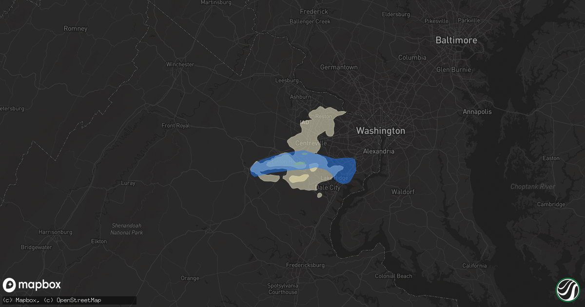
Hail Map in Manassas, VA on May 26, 2021
Get this storm
May 26 map
$229
one time, instant access
Download today. No call, no setup
Keep the $229
Bought the map and want the full workflow? Apply the entire $229 to a subscription within 7 days. None of it is wasted.
Every map, not just this one
This buys you this map. Subscription and you get every map we run, in the markets you choose from a few cities to whole states to nationwide. Plus real-time alerts the moment a storm fires.
Contact data
Name, contact info, occupancy, even credit band for addresses in the footprint. You go from where it hit to who to call.
Become the source they trust
Unlimited branding weather history reports on demand. You already have the documented answer ready for the property owner, and you are the one who showed up with it.
Property data and RoofTrace estimates
Pull up any address you have got, its value and the exact code rules for that jurisdiction, straight from One Click Code. Then RoofTrace estimates the squares, pitch, and roof value, priced the way you price.
Storm reports in Manassas, VA
Manassas, VA
| Date | Description |
|---|---|
| 05/26/20213:42 PM CDT | A local report indicates 1.00 inch wind near 2 NW MANASSAS PARK |
| 05/26/20213:40 PM CDT | A local report indicates 1.00 inch wind near MANASSAS |
| 05/26/20213:38 PM CDT | Numerous trees down on the 9000 block of centreville road. |
| 05/26/20213:35 PM CDT | Tree fell on mobile home and destroyed it. |
| 05/26/20213:35 PM CDT | Multiple tree limbs broken off trees at the intersection of sudley road and centerville road. |
| 05/26/20213:32 PM CDT | Tree blew down on fairview avenue next to the manassas police station. |
All States Impacted by Hail Map on May 26, 2021
All Cities Impacted by Hail Map on May 26, 2021
- Geneseo, KS
- Lorraine, KS
- New Cambria, KS
- Gypsum, KS
- Salina, KS
- Solomon, KS
- Clay Center, KS
- Greenleaf, KS
- Woodston, KS
- Linn, KS
- Kirwin, KS
- Green, KS
- Palco, KS
- Agenda, KS
- Alton, KS
- Jewell, KS
- Barnes, KS
- Jamestown, KS
- Damar, KS
- Hill City, KS
- Bogue, KS
- Cuba, KS
- Norway, KS
- Randall, KS
- Morland, KS
- Concordia, KS
- Downs, KS
- Clifton, KS
- Osborne, KS
- Esbon, KS
- Blue Rapids, KS
- Frankfort, KS
- Belleville, KS
- Clyde, KS
- Cawker City, KS
- Morganville, KS
- Waterville, KS
- Palmer, KS
- Randolph, KS
- Plainville, KS
- Beloit, KS
- Scandia, KS
- Mankato, KS
- Haddam, KS
- Portis, KS
- Stockton, KS
- Glen Elder, KS
- Penokee, KS
- Lance Creek, WY
- Lyons, KS
- Lenora, KS
- Ellis, KS
- Gillette, WY
- Upton, WY
- Albin, WY
- Dimmitt, TX
- Springlake, TX
- Earth, TX
- Hart, TX
- Poughquag, NY
- Stormville, NY
- Wappingers Falls, NY
- Poughkeepsie, NY
- Hopewell Junction, NY
- Lagrangeville, NY
- Muleshoe, TX
- Danbury, NE
- Oberlin, KS
- Monahans, TX
- Barstow, TX
- Stockville, NE
- Curtis, NE
- Edgemont, SD
- Thayer, KS
- Hemingford, NE
- Grant, NE
- McCune, KS
- Cozad, NE
- Lexington, NE
- Hays, KS
- Schoenchen, KS
- Ovid, CO
- Keystone, NE
- Holdrege, NE
- Phillipsburg, KS
- Little River, KS
- Windom, KS
- Hoxie, KS
- Benkelman, NE
- Palisade, NE
- Wauneta, NE
- Liebenthal, KS
- Victoria, KS
- Walker, KS
- La Crosse, KS
- Bison, KS
- McCook, NE
- Perryton, TX
- Imperial, NE
- Madrid, NE
- Elsie, NE
- Venango, NE
- Spearman, TX
- Gruver, TX
- Booker, TX
- Balko, OK
- Culbertson, NE
- Funk, NE
- Herndon, KS
- Mcpherson, KS
- Colby, KS
- Levant, KS
- Brewster, KS
- Anselmo, NE
- Arnold, NE
- Stapleton, NE
- Lovettsville, VA
- Waterford, VA
- Purcellville, VA
- Minden, NE
- Loomis, NE
- Crawford, NE
- Atwood, KS
- Kress, TX
- Tulia, TX
- Keymar, MD
- Rocky Ridge, MD
- Brookville, KS
- White Deer, TX
- Panhandle, TX
- Stratton, NE
- Enders, NE
- Trenton, NE
- Hayes Center, NE
- Max, NE
- Fall River, KS
- Canyon, TX
- Amarillo, TX
- Goodland, KS
- Gurley, NE
- Dalton, NE
- Belle Fourche, SD
- Quenemo, KS
- Osage City, KS
- Shippensburg, PA
- Biglerville, PA
- Saugerties, NY
- Russell, KS
- Bunker Hill, KS
- Gorham, KS
- Harveyville, KS
- Sutherland, NE
- Edson, KS
- Selden, KS
- Norcatur, KS
- Amherst, TX
- Fieldton, TX
- Hale Center, TX
- Olton, TX
- Littlefield, TX
- Gardners, PA
- Bechtelsville, PA
- Boyertown, PA
- Gilbertsville, PA
- Jonestown, PA
- Pine Grove, PA
- Annville, PA
- Sterling, CO
- Moorcroft, WY
- Emporia, KS
- Reading, KS
- White City, KS
- Council Grove, KS
- Annapolis Junction, MD
- Hanover, MD
- Savage, MD
- Laurel, MD
- Columbia, MD
- Elkridge, MD
- Jessup, MD
- Julesburg, CO
- Sudan, TX
- Plainview, TX
- Lincolnville, KS
- Marion, KS
- Tatum, NM
- Elwood, NE
- Bridgeport, NE
- Port Royal, PA
- Honey Grove, PA
- Hershey, NE
- Jal, NM
- Broadwater, NE
- Admire, KS
- Beaver, OK
- Hardesty, OK
- Manassas, VA
- Nokesville, VA
- Bristow, VA
- Lincoln, KS
- Ellsworth, KS
- Wilson, KS
- Alma, NE
- Wilsonville, NE
- Maywood, NE
- Almena, KS
- Prairie View, KS
- Oxford, NE
- Long Island, KS
- Bartley, NE
- Smith Center, KS
- Jennings, KS
- Agra, KS
- Moorefield, NE
- Kensington, KS
- Cambridge, NE
- Ludell, KS
- Farnam, NE
- Stamford, NE
- Gaylord, KS
- Logan, KS
- Lebanon, NE
- Clayton, KS
- Indianola, NE
- Glade, KS
- Beaver City, NE
- Norton, KS
- Eustis, NE
- Athol, KS
- Hendley, NE
- Orleans, NE
- Rockville Centre, NY
- Oceanside, NY
- Baldwin, NY
- Ellicott City, MD
- Boonsboro, MD
- Catlett, VA
- Benton, PA
- Harrisburg, NE
- Abernathy, TX
- Unityville, PA
- Millville, PA
- Clinton, MD
- Alexandria, VA
- Fort Washington, MD
- Bryans Road, MD
- Accokeek, MD
- Fort Belvoir, VA
- Hereford, TX
- Claflin, KS
- Holyrood, KS
- Marquette, KS
- Sylvan Grove, KS
- Dorrance, KS
- Waldo, KS
- Bushton, KS
- Hoisington, KS
- Moundridge, KS
- Inman, KS
- Chase, KS
- Canton, KS
- Galva, KS
- Kanopolis, KS
- Goessel, KS
- Gainesville, VA
- Watertown, CT
- Thomaston, CT
- Leesburg, VA
- Pampa, TX
- Merriman, NE
- Gordon, NE
- Bingham, NE
- Ashby, NE
- Wellington, KS
- Clifton, VA
- Lykens, PA
- Hegins, PA
- Valley View, PA
- Sacramento, PA
- Spring Glen, PA
- Tower City, PA
- Williamstown, PA
- Ephrata, PA
- Denver, PA
- Stevens, PA
- New Holland, PA
- Ogallah, KS
- Wakeeney, KS
- Oshkosh, NE
- Hay Springs, NE
- Ellsworth, NE
- Fort Davis, TX
- Fredericksburg, PA
- Pine Bluffs, WY
- Bel Air, MD
- Havre De Grace, MD
- Churchville, MD
- Mayfield, KS
- Fairfield, PA
- Spring Run, PA
- Dry Run, PA
- Newburg, PA
- Amberson, PA
- New Germantown, PA
- Dodge City, KS
- Ensign, KS
- Cimarron, KS
- Rushville, NE
- Chappell, NE
- Lodgepole, NE
- Burlingame, KS
- Lovington, NM
- Meshoppen, PA
- Mehoopany, PA
- Whitney, NE
- Harrison, NE
- Marsland, NE
- Hampton, CT
- Chaplin, CT
- Schuylkill Haven, PA
- Reading, PA
- Bird City, KS
- Chadron, NE
- Stoneham, CO
- Newcastle, WY
- East Earl, PA
- Anton, TX
- Germantown, NY
- Elizaville, NY
- Tivoli, NY
- Douglassville, PA
- Oley, PA
- Hamburg, PA
- Kutztown, PA
- Pottstown, PA
- Mertztown, PA
- Lyon Station, PA
- Fleetwood, PA
- Alburtis, PA
- Perkiomenville, PA
- Frederick, PA
- Barto, PA
- Blandon, PA
- Macungie, PA
- Leesport, PA
- Shoemakersville, PA
- Lakeside, NE
- Alliance, NE
- Skellytown, TX
- Waverly, KS
- Douglas, WY
- Weldona, CO
- Philadelphia, PA
- Camden, NJ
- Shallowater, TX
- McDonald, KS
- Fredonia, KS
- Longton, KS
- Elk City, KS
- Neodesha, KS
- Peetz, CO
- Padroni, CO
- Paxton, NE
- Haymarket, VA
- Broad Run, VA
- Warrenton, VA
- Lemoyne, PA
- Camp Hill, PA
- Morgantown, WV
- Fairmont, WV
- Red Hook, NY
- Brule, NE
- Big Springs, NE
- Champion, NE
- The Plains, VA
- North Platte, NE
- Montezuma, KS
- Durham, KS
- Lost Springs, KS
- Halstead, KS
- Peabody, KS
- Lehigh, KS
- Hesston, KS
- Newton, KS
- Walton, KS
- Roxbury, KS
- Hillsboro, KS
- Ramona, KS
- Tampa, KS
- Lindsborg, KS
- North Newton, KS
- Beverly, KS
- Pfeifer, KS
- Luray, KS
- McCracken, KS
- Lorton, VA
- Springfield, VA
- Reston, VA
- Fairfax Station, VA
- Herndon, VA
- Chantilly, VA
- McLean, VA
- Vienna, VA
- Oakton, VA
- Sterling, VA
- Centreville, VA
- Fairfax, VA
- Woodbridge, VA
- Great Falls, VA
- Catharpin, VA
- Eskridge, KS
- Darlington, MD
- Milan, KS
- Argonia, KS
- Malden On Hudson, NY
- Barrytown, NY
- Fulton, MD
- Severn, MD
- Spencerville, MD
- Harmans, MD
- Glen Burnie, MD
- Burtonsville, MD
- Fort George G Meade, MD
- Ogallala, NE
- Mohnton, PA
- Birdsboro, PA
- Pecos, TX
- Pyote, TX
- Tryon, NE
- Emmitsburg, MD
- Thurmont, MD
- Woodsboro, MD
- Severy, KS
- Eureka, KS
- Piedmont, KS
- Lakewood, NJ
- Newville, PA
- Winona, KS
- Formoso, KS
- Courtland, KS
- Muncy, PA
- Lairdsville, PA
- Port Deposit, MD
- Groom, TX
- Claude, TX
- Coyanosa, TX
- Sabillasville, MD
- Waynesboro, PA
- Gettysburg, PA
- Blue Ridge Summit, PA
- Cascade, MD
- Plains, KS
- Happy, TX
- Shermans Dale, PA
- New Bloomfield, PA
- Duncannon, PA
- Levelland, TX
- Elizabethville, PA
- Halifax, PA
- Americus, KS
- Middletown, DE
- Silverton, TX
- Hot Springs, SD
- Torrington, WY
- Ashton, MD
- Sandy Spring, MD
- Olney, MD
- Silver Spring, MD
- Eddyville, NE
- Dumfries, VA
- Alva, OK
- Burlington, OK
- Altoona, KS
- Laverne, OK
- Benedict, KS
- Howard, KS
- Brick, NJ
- Scranton, KS
- Buffalo, OK
- Leoti, KS
- Bertrand, NE
- Coopersburg, PA
- Quakertown, PA
- Fort Morgan, CO
- Toms River, NJ
- Sidney, NE
- Lyndon, KS
- Hainesport, NJ
- Lumberton, NJ
- Mount Laurel, NJ
- Tescott, KS
- Point Pleasant Beach, NJ
- Whitehouse Station, NJ
- Chanute, KS
- Auburn, KS
- Topeka, KS
- Orrtanna, PA
- Fayetteville, PA
- Stephens City, VA
- Middletown, VA
- Maple Shade, NJ
- Merchantville, NJ
- Riverton, NJ
- Moorestown, NJ
- Cherry Hill, NJ
- Pennsauken, NJ
- Lewellen, NE
- Atlanta, NE
- Street, MD
- Pylesville, MD
- Mentone, TX
- Wakarusa, KS
- Carbondale, KS
- White Hall, MD
- Whiteford, MD
- Parkton, MD
- Beachwood, NJ
- Forked River, NJ
- Manchester Township, NJ
- Bayville, NJ
- Lanoka Harbor, NJ
- Island Heights, NJ
- Pine Beach, NJ
- Millerstown, PA
- Dalmatia, PA
- Liverpool, PA
- Port Trevorton, PA
- Mount Pleasant Mills, PA
- Millersburg, PA
- Jacob, IL
- Gorham, IL
- Nash, OK
- Pond Creek, OK
- Jet, OK
- Cherokee, OK
- Medford, OK
- Arthur, NE
- Lemoyne, NE
- Hildreth, NE
- Wilcox, NE
- Axtell, NE
- Elm Creek, NE
- Overton, NE
- Osage, WY
- Roswell, NM
- Dexter, NM
- Nazareth, TX
- Friona, TX
- Grandfalls, TX
- East Syracuse, NY
- Durhamville, NY
- Fayetteville, NY
- Wampsville, NY
- Jamesville, NY
- Bridgeport, NY
- Verona Beach, NY
- Kirkville, NY
- Rome, NY
- Marcellus, NY
- Auburn, NY
- Minoa, NY
- Verona, NY
- Chittenango, NY
- Canastota, NY
- Oneida, NY
- Cleveland, NY
- Elbridge, NY
- Syracuse, NY
- Skaneateles, NY
- Skaneateles Falls, NY
- Camillus, NY
- West Edmeston, NY
- West Winfield, NY
- Waterville, NY
- Cambridge, NY
- Eagle Bridge, NY
- Arlington, VT
- Shaftsbury, VT
- Shushan, NY
- Buskirk, NY
- North Bennington, VT
- Hoosick Falls, NY
- Manchester Center, VT
- East Arlington, VT
- East Montpelier, VT
- Plainfield, VT
- East Calais, VT
- Adamant, VT
- Granville, VT
- Barre, VT
- Bridport, VT
- North Montpelier, VT
- Ripton, VT
- Danville, VT
- Northfield, VT
- Moretown, VT
- Salisbury, VT
- New Haven, VT
- Montpelier, VT
- Marshfield, VT
- Cabot, VT
- East Ryegate, VT
- Monroe, NH
- Starksboro, VT
- Barnet, VT
- Warren, VT
- Groton, VT
- West Danville, VT
- Waitsfield, VT
- Middlebury, VT
- Bristol, VT
- Roxbury, VT
- Peacham, VT
- Saint Johnsbury, VT
- Cornish, NH
- Windsor, VT
- Brownsville, VT
- Plainfield, NH
- Meriden, NH
- Claremont, NH
- Sunapee, NH
- Charlestown, NH
- Newport, NH
- Wolfeboro, NH
- Moultonborough, NH
- Center Tuftonboro, NH
- Gilford, NH
- Laconia, NH
- Ossipee, NH
- Alton Bay, NH
- Sanbornton, NH
- Meredith, NH
- Mirror Lake, NH
- Occoquan, VA
- Burke, VA
- Mount Rainier, MD
- Washington, DC
- Takoma Park, MD
- Brentwood, MD
- Hyattsville, MD
- Bladensburg, MD
- Cabin John, MD
- Glen Echo, MD
- Riverdale, MD
- Arlington, VA
- Potomac, MD
- Chevy Chase, MD
- College Park, MD
- Bethesda, MD
- Indian Head, MD
- Pomfret, MD
- Waldorf, MD
- White Plains, MD
- Bryantown, MD
- La Plata, MD
- Ellinwood, KS
- Derby, KS
- Goddard, KS
- Andover, KS
- Rose Hill, KS
- Towanda, KS
- Augusta, KS
- Conway Springs, KS
- Benton, KS
- Viola, KS
- Wichita, KS
- Mcconnell Afb, KS
- Clearwater, KS
- Herington, KS
- Burdick, KS
- Toronto, KS
- Buffalo, KS
- Dwight, KS
- Alta Vista, KS
- Ottawa, KS
- Wellsville, KS
- Baldwin City, KS
- Pomona, KS
- Overbrook, KS
- Kersey, CO
- Snyder, CO
- Monument, KS
- Copeland, KS
- Berrysburg, PA
- Newport, PA
- Gratz, PA
- New Oxford, PA
- Slickville, PA
- Duquesne, PA
- Coral, PA
- New Florence, PA
- Vintondale, PA
- North Versailles, PA
- Braddock, PA
- Black Lick, PA
- West Mifflin, PA
- Irwin, PA
- Jeannette, PA
- Seward, PA
- Monroeville, PA
- Turtle Creek, PA
- Robinson, PA
- Johnstown, PA
- Mckeesport, PA
- Armagh, PA
- Dilltown, PA
- Pitcairn, PA
- East Pittsburgh, PA
- Homer City, PA
- Claridge, PA
- East McKeesport, PA
- Harrison City, PA
- Greensburg, PA
- Delmont, PA
- Ardara, PA
- Clarksburg, PA
- Josephine, PA
- Wilmerding, PA
- Export, PA
- Saltsburg, PA
- Trafford, PA
- Pittsburgh, PA
- Blairsville, PA
- Murrysville, PA
- Homestead, PA
- Derry, PA
- New Alexandria, PA
- Short Hills, NJ
- East Hanover, NJ
- Summit, NJ
- Green Village, NJ
- Mendham, NJ
- Morris Plains, NJ
- Whippany, NJ
- Madison, NJ
- Cedar Knolls, NJ
- Morristown, NJ
- New Vernon, NJ
- Livingston, NJ
- Bernardsville, NJ
- Florham Park, NJ
- Basking Ridge, NJ
- Chatham, NJ
- Kingston, NJ
- Center Valley, PA
- Phoenixville, PA
- North Wales, PA
- Ambler, PA
- Glenmoore, PA
- Plymouth Meeting, PA
- Hellertown, PA
- Ottsville, PA
- Robbinsville, NJ
- Topton, PA
- Harleysville, PA
- Breinigsville, PA
- Oaks, PA
- Stockton, NJ
- Montgomeryville, PA
- Temple, PA
- Upper Black Eddy, PA
- Palm, PA
- Lenhartsville, PA
- Franklin Park, NJ
- Trumbauersville, PA
- Green Lane, PA
- Auburn, PA
- North Brunswick, NJ
- Monroe Township, NJ
- Warminster, PA
- Furlong, PA
- Dresher, PA
- Telford, PA
- Titusville, NJ
- Zionsville, PA
- Dayton, NJ
- Monmouth Junction, NJ
- Princeton Junction, NJ
- Adamstown, PA
- Honey Brook, PA
- Blue Bell, PA
- Hatboro, PA
- Souderton, PA
- Lumberville, PA
- Hereford, PA
- Silverdale, PA
- Reinholds, PA
- Royersford, PA
- Lambertville, NJ
- Belle Mead, NJ
- Feasterville Trevose, PA
- Jamison, PA
- Ringoes, NJ
- Fort Washington, PA
- Richlandtown, PA
- Hilltown, PA
- Gwynedd, PA
- Willow Grove, PA
- Dublin, PA
- Hillsborough, NJ
- Trexlertown, PA
- Plainsboro, NJ
- Line Lexington, PA
- Emmaus, PA
- Pipersville, PA
- Schwenksville, PA
- Washington Crossing, PA
- Skillman, NJ
- Cranbury, NJ
- Morrisville, PA
- Terre Hill, PA
- Richboro, PA
- Frenchtown, NJ
- Carversville, PA
- Bally, PA
- Norristown, PA
- Warrington, PA
- Lansdale, PA
- Langhorne, PA
- Pennsburg, PA
- Port Clinton, PA
- Morgantown, PA
- Huntingdon Valley, PA
- Kintnersville, PA
- Sellersville, PA
- Kendall Park, NJ
- Chalfont, PA
- Zieglerville, PA
- Bethlehem, PA
- Colmar, PA
- Mont Clare, PA
- Erwinna, PA
- Flemington, NJ
- Skippack, PA
- Spring City, PA
- Narvon, PA
- Fountainville, PA
- Hatfield, PA
- Riegelsville, PA
- Hightstown, NJ
- East Greenville, PA
- Newtown, PA
- Red Hill, PA
- Lawrence Township, NJ
- Doylestown, PA
- Perkasie, PA
- Rocky Hill, NJ
- Spring House, PA
- Point Pleasant, PA
- Collegeville, PA
- Horsham, PA
- Elverson, PA
- Chester Springs, PA
- Allentown, PA
- Trenton, NJ
- New Hope, PA
- Princeton, NJ
- Pennington, NJ
- Hopewell, NJ
- Southampton, PA


