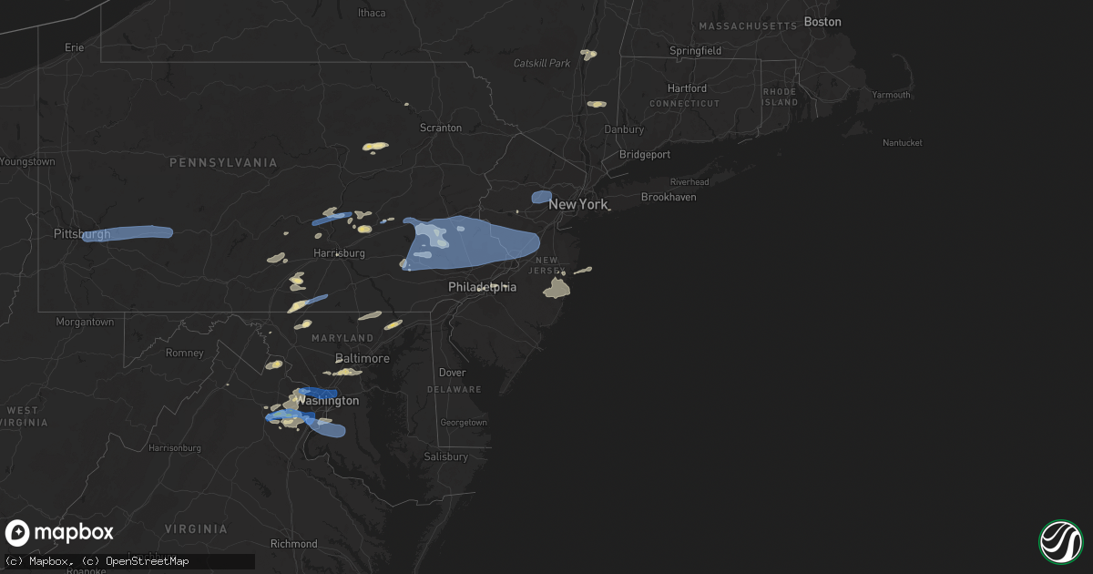
Hail Map in New Jersey on May 26, 2021
Get this storm
May 26 map
$229
one time, instant access
Download today. No call, no setup
Keep the $229
Bought the map and want the full workflow? Apply the entire $229 to a subscription within 7 days. None of it is wasted.
Every map, not just this one
This buys you this map. Subscription and you get every map we run, in the markets you choose from a few cities to whole states to nationwide. Plus real-time alerts the moment a storm fires.
Contact data
Name, contact info, occupancy, even credit band for addresses in the footprint. You go from where it hit to who to call.
Become the source they trust
Unlimited branding weather history reports on demand. You already have the documented answer ready for the property owner, and you are the one who showed up with it.
Property data and RoofTrace estimates
Pull up any address you have got, its value and the exact code rules for that jurisdiction, straight from One Click Code. Then RoofTrace estimates the squares, pitch, and roof value, priced the way you price.
Storm reports in New Jersey
New Jersey
| Date | Description |
|---|---|
| 05/26/20216:38 PM CDT | Njwxnet measured gust. |
| 05/26/20216:06 PM CDT | Tree down on road. |
| 05/26/20216:05 PM CDT | Downed tree limbs and wires reported in a few locations in and near the brielle area. Time estimated from radar. |
| 05/26/20215:51 PM CDT | Large tree limb down. Time estimated by radar. |
| 05/26/20215:49 PM CDT | Downed tree on state highway 35 near mulberry lane. All lanes closed. Time estimated from radar. |
| 05/26/20215:39 PM CDT | Downed tree limbs and wires near deerfield lane. Time estimated from radar. |
| 05/26/20215:35 PM CDT | Large tree was uprooted on charles street and is leaning on power lines. |
| 05/26/20215:33 PM CDT | Multiple tree limbs down in the area. Time reported from the observer. |
| 05/26/20215:30 PM CDT | Downed tree limbs and wires near tabor road. Time estimated from radar. |
| 05/26/20215:29 PM CDT | Downed tree limbs and wires near park road. Time estimated from radar. |
| 05/26/20215:27 PM CDT | Downed trees and wires near valley road. Time estimated from radar. |
| 05/26/20215:27 PM CDT | Downed trees and wires reported in long hill and millington. Time estimated from radar. |
| 05/26/20215:24 PM CDT | Downed tree limbs and wires near mountain avenue. Time estimated from radar. |
| 05/26/20215:22 PM CDT | Downed tree limbs and wires reported in several locations between lyons and millington. Time estimated from radar. |
| 05/26/20215:19 PM CDT | Downed tree limbs and wires near rivercrest drive. Time estimated from radar. |
| 05/26/20215:19 PM CDT | Downed tree on u.s. Highway 202 southbound north of county road 613. Lane restrictions required. Time estimated from radar. |
| 05/26/20215:17 PM CDT | Downed tree limbs and wires near seymour terrace. Time estimated from radar. |
| 05/26/20215:17 PM CDT | Downed tree limbs and wires near woodland road. Time estimated from radar. |
| 05/26/20215:14 PM CDT | Several reports of downed trees and wires in mendham. Time estimated from radar. |
| 05/26/20215:14 PM CDT | Reports of downed trees and wires in the somerville area. Time estimated from radar. |
| 05/26/20215:12 PM CDT | Downed tree on u.s. Highway 130 southbound ramp to ridge road. All lanes closed. Time estimated from radar. |
| 05/26/20215:10 PM CDT | Tree down in palmyra. Time estimated. |
| 05/26/20215:08 PM CDT | Tree split in half. |
| 05/26/20215:07 PM CDT | Downed tree limbs and wires near south lane. Time estimated from radar. |
| 05/26/20215:05 PM CDT | Downed tree limbs and wires reported in a few locations in the manville area. Time estimated from radar. |
| 05/26/20215:04 PM CDT | Downed tree limbs and wires near bunting avenue. Time estimated from radar. |
| 05/26/20215:00 PM CDT | Widespread power outages in the area. Time estimated from radar. |
| 05/26/20214:59 PM CDT | Downed trees and wires near summer road. Time estimated from radar. |
| 05/26/20214:56 PM CDT | Downed trees and wires near schooleys mountain road. Time estimated from radar. |
| 05/26/20214:54 PM CDT | Downed trees and wires near allerton and clinton. Time estimated from radar. |
| 05/26/20214:52 PM CDT | Downed wires near bunnvale road and hill drive east. Time estimated from radar. |
| 05/26/20214:39 PM CDT | Downed trees and wires near asbury west portal road. Time estimated from radar. |
| 05/26/20214:35 PM CDT | Downed trees and wires near montana road. Time estimated from radar. |
| 05/26/20216:20 AM CDT | At 1120 PM EDT, a severe thunderstorm was located near Bamber Lake, or 12 miles southwest of Toms River, moving east at 55 mph. HAZARD...60 mph wind gusts and penny size hail. SOURCE...Radar indicated. IMPACT...Damage to roofs, siding, trees, and power lines is possible. Locations impacted include... Toms River, Barnegat, Beachwood, Seaside Heights, Dover Beaches North, Holiday City South, Pleasant Plains, Warren Grove, Dover Beaches South, Holiday City-Berkeley, Bamber Lake, Cedar Glen Lakes, Whiting, Brookville, Pine Ridge At Crestwood, Leisure Village West-Pine Lake Park, South Toms River, Island Heights, Silver Ridge and Ocean Acres.This includes Garden State Parkway between mile markers 64 and 85. |
| 05/26/20215:40 AM CDT | At 1040 PM EDT, a severe thunderstorm was located over Chesilhurst, or 17 miles north of Vineland, moving east at 40 mph. HAZARD...60 mph wind gusts and quarter size hail. SOURCE...Radar indicated. IMPACT...Minor damage to vehicles is possible. Wind damage to roofs, siding, trees, and power lines is possible. Locations impacted include... Hammonton, Berlin, Tabernacle, Shamong, Chesilhurst, Atco, Sicklerville, Wharton State Forest, Atsion, Batsto, Chatsworth, Penn State Forest, Marlton Lakes, Williamstown, Pine Hill, Folsom, Pine Valley and Collings Lakes.This includes Atlantic City Expressway between mile markers 26 and41. |
| 05/26/20215:35 AM CDT | At 1035 PM EDT, a severe thunderstorm was located over Mount Laurel, or 11 miles east of Camden, moving east at 30 mph. HAZARD...60 mph wind gusts. SOURCE...Radar indicated. IMPACT...Damage to roofs, siding, trees, and power lines is possible. Locations impacted include... Cherry Hill, Evesham, Mount Laurel, Willingboro, Medford, Lumberton, Burlington, Mount Holly, Tabernacle, Shamong, Presidential Lakes Estates, Pemberton, Wrightstown, Ramblewood, Barclay-Kingston, Cherry Hill Mall, Marlton, Leisuretowne, Jacksonville and Presidential Lakes.People at the Burlington County Mega Site should seek safe shelterimmediately!This includes the following highways... New Jersey Turnpike between exits 4 and 5. Interstate 295 in New Jersey between mile markers 34 and 48. |
| 05/26/20211:54 AM CDT | At 653 PM EDT, severe thunderstorms were located along a line extending from near Ringwood to Wayne, moving east at 25 mph. HAZARD...60 mph wind gusts. SOURCE...Radar indicated. IMPACT...Expect damage to trees and power lines. Severe thunderstorms will be near... Suffern and Sloatsburg around 705 PM EDT. Ridgewood and Ramsey around 710 PM EDT. Monsey around 715 PM EDT. Pomona around 720 PM EDT. New City and Nanuet around 725 PM EDT. Haverstraw and Tappan around 730 PM EDT. Orangeburg around 735 PM EDT. Peekskill and Dobbs Ferry around 740 PM EDT.This includes the following New York State COVID tent site Anthony Wayne Rec Center. |
| 05/26/20211:12 AM CDT | At 611 PM EDT, severe thunderstorms were located along a line extending from Succasunna-Kenvil to Lawrenceville, moving east at 40 mph. HAZARD...60 mph wind gusts. SOURCE...Radar indicated. IMPACT...Expect damage to trees and power lines. Severe thunderstorms will be near... Fairfield around 640 PM EDT. Caldwell around 645 PM EDT. Bloomfield around 650 PM EDT. Paterson and Passaic around 655 PM EDT. Paramus and Teterboro around 700 PM EDT. Hackensack and Ridgefield around 705 PM EDT. Bergenfield and Fort Lee around 710 PM EDT.This includes the following New York State COVID tent site Staten Island OMH. |
| 05/26/20211:08 AM CDT | At 608 PM EDT, severe thunderstorms were located along a line extending from near Budd Lake to White House Station, moving east at 30 mph. HAZARD...60 mph wind gusts. SOURCE...Radar indicated. IMPACT...Damage to roofs, siding, trees, and power lines is possible. Locations impacted include... Perth Amboy, Morristown, Somerville, Edison, Bridgewater, Carteret, Dover, Madison, Middlesex, Florham Park, East Hanover, Bound Brook, Manville, Chatham, Boonton, Wharton, Rockaway, Morris Plains, Mount Arlington and Mendham.People at the Morris County Mega Site should seek safe shelterimmediately!This includes the following highways... New Jersey Turnpike between exits 11 and 12. Interstate 78 in New Jersey between mile markers 25 and 41. Interstate 80 in New Jersey between mile markers 30 and 48. Interstate 287 in New Jersey between mile markers 0 and 9, andbetween mile markers 12 and 46. Garden State Parkway between mile markers 126 and 133. |
| 05/26/202112:27 AM CDT | At 527 PM EDT, severe thunderstorms were located along a line extending from Milford to Dublin to Glenmoore, moving east at 30 mph. HAZARD...70 mph wind gusts and penny size hail. SOURCE...Radar indicated. IMPACT...Expect considerable tree damage. Damage is likely to mobile homes, roofs, and outbuildings. Locations impacted include... Philadelphia, Ewing, Norristown, Pottstown, Phoenixville, Lansdale, West Norriton, East Norriton, Quakertown, Perkasie, Doylestown, Byram, Downingtown, Conshohocken, Hatboro, Souderton, Bedminster, Ambler, Collegeville and Royersford.This includes the following highways... Pennsylvania Turnpike between mile markers 298 and 349. Northeast Extension between mile markers 21 and 42. Interstate 76 in Pennsylvania between mile markers 327 and 338. Interstate 295 in New Jersey between mile markers 73 and 76. Interstate 476 in Pennsylvania between mile markers 10 and 19. |
| 05/25/202111:46 PM CDT | At 445 PM EDT, severe thunderstorms were located along a line extending from near Coffeetown to near Bechtelsville to New Morgan, moving east at 45 mph. HAZARD...70 mph wind gusts and penny size hail. SOURCE...Radar indicated. IMPACT...Expect considerable tree damage. Damage is likely to mobile homes, roofs, and outbuildings. Locations impacted include... Allentown, Easton, Bethlehem, Norristown, Pottstown, Phoenixville, Lansdale, West Norriton, East Norriton, Emmaus, Quakertown, Perkasie, Doylestown, Souderton, Bedminster, Hellertown, Collegeville, Royersford, Chalfont and Tinicum.This includes the following highways... Pennsylvania Turnpike between mile markers 298 and 304, and betweenmile markers 330 and 333. Northeast Extension between mile markers 21 and 53. Interstate 78 in Pennsylvania between mile markers 57 and 73. Interstate 476 in Pennsylvania between mile markers 18 and 19. |
| 05/25/202110:20 PM CDT | Downed tree limbs and wires near sea breeze drive. Time estimated from radar. |
| 05/25/20219:53 PM CDT | Downed tree limbs and wires near weekstown road. Time estimated from radar. |
| 05/25/20219:53 PM CDT | Tree down in medford. Time estimated by radar. |
| 05/25/20219:47 PM CDT | Downed wires near nesco road. Time estimated from radar. |
| 05/25/20219:42 PM CDT | Downed wires near lambert drive. Time estimated from radar. |
| 05/25/20219:42 PM CDT | Downed tree limbs and wires near shreve street. Time estimated from radar. |
| 05/25/20219:40 PM CDT | Downed tree limbs and wires near nottingham drive. Time estimated from radar. |
| 05/25/20219:37 PM CDT | Downed tree limbs and wires near globe lane. Time estimated from radar. |
| 05/25/20219:35 PM CDT | Downed wires near hemlock lane. Time estimated from radar. |
| 05/25/20219:27 PM CDT | Several reports of downed tree limbs and wires near glassboro cross keys road. Time estimated from radar. |
| 05/25/20219:23 PM CDT | Corrects previous tstm wnd dmg report from palmyra. Trees down in palmyra. |
| 05/25/20219:22 PM CDT | Several reports of downed tree limbs and wires in the pennsauken area. Time estimated from radar. |
| 05/25/20219:19 PM CDT | Several reports of downed tree limbs and wires near jessup road and in west deptford twp. Time estimated from radar. |
| 05/25/20219:15 PM CDT | Several reports of downed tree limbs and wires in far northeastern portions of salem county. Time estimated from radar. |
All States Impacted by Hail Map on May 26, 2021
Cities Impacted by Hail Map on May 26, 2021
- Geneseo, KS
- Lorraine, KS
- New Cambria, KS
- Gypsum, KS
- Salina, KS
- Solomon, KS
- Clay Center, KS
- Greenleaf, KS
- Woodston, KS
- Linn, KS
- Kirwin, KS
- Green, KS
- Palco, KS
- Agenda, KS
- Alton, KS
- Jewell, KS
- Barnes, KS
- Jamestown, KS
- Damar, KS
- Hill City, KS
- Bogue, KS
- Cuba, KS
- Norway, KS
- Randall, KS
- Morland, KS
- Concordia, KS
- Downs, KS
- Clifton, KS
- Osborne, KS
- Esbon, KS
- Blue Rapids, KS
- Frankfort, KS
- Belleville, KS
- Clyde, KS
- Cawker City, KS
- Morganville, KS
- Waterville, KS
- Palmer, KS
- Randolph, KS
- Plainville, KS
- Beloit, KS
- Scandia, KS
- Mankato, KS
- Haddam, KS
- Portis, KS
- Stockton, KS
- Glen Elder, KS
- Penokee, KS
- Lance Creek, WY
- Lyons, KS
- Lenora, KS
- Ellis, KS
- Gillette, WY
- Upton, WY
- Albin, WY
- Dimmitt, TX
- Springlake, TX
- Earth, TX
- Hart, TX
- Poughquag, NY
- Stormville, NY
- Wappingers Falls, NY
- Poughkeepsie, NY
- Hopewell Junction, NY
- Lagrangeville, NY
- Muleshoe, TX
- Danbury, NE
- Oberlin, KS
- Monahans, TX
- Barstow, TX
- Stockville, NE
- Curtis, NE
- Edgemont, SD
- Thayer, KS
- Hemingford, NE
- Grant, NE
- McCune, KS
- Cozad, NE
- Lexington, NE
- Hays, KS
- Schoenchen, KS
- Ovid, CO
- Keystone, NE
- Holdrege, NE
- Phillipsburg, KS
- Little River, KS
- Windom, KS
- Hoxie, KS
- Benkelman, NE
- Palisade, NE
- Wauneta, NE
- Liebenthal, KS
- Victoria, KS
- Walker, KS
- La Crosse, KS
- Bison, KS
- McCook, NE
- Perryton, TX
- Imperial, NE
- Madrid, NE
- Elsie, NE
- Venango, NE
- Spearman, TX
- Gruver, TX
- Booker, TX
- Balko, OK
- Culbertson, NE
- Funk, NE
- Herndon, KS
- Mcpherson, KS
- Colby, KS
- Levant, KS
- Brewster, KS
- Anselmo, NE
- Arnold, NE
- Stapleton, NE
- Lovettsville, VA
- Waterford, VA
- Purcellville, VA
- Minden, NE
- Loomis, NE
- Crawford, NE
- Atwood, KS
- Kress, TX
- Tulia, TX
- Keymar, MD
- Rocky Ridge, MD
- Brookville, KS
- White Deer, TX
- Panhandle, TX
- Stratton, NE
- Enders, NE
- Trenton, NE
- Hayes Center, NE
- Max, NE
- Fall River, KS
- Canyon, TX
- Amarillo, TX
- Goodland, KS
- Gurley, NE
- Dalton, NE
- Belle Fourche, SD
- Quenemo, KS
- Osage City, KS
- Shippensburg, PA
- Biglerville, PA
- Saugerties, NY
- Russell, KS
- Bunker Hill, KS
- Gorham, KS
- Harveyville, KS
- Sutherland, NE
- Edson, KS
- Selden, KS
- Norcatur, KS
- Amherst, TX
- Fieldton, TX
- Hale Center, TX
- Olton, TX
- Littlefield, TX
- Gardners, PA
- Bechtelsville, PA
- Boyertown, PA
- Gilbertsville, PA
- Jonestown, PA
- Pine Grove, PA
- Annville, PA
- Sterling, CO
- Moorcroft, WY
- Emporia, KS
- Reading, KS
- White City, KS
- Council Grove, KS
- Annapolis Junction, MD
- Hanover, MD
- Savage, MD
- Laurel, MD
- Columbia, MD
- Elkridge, MD
- Jessup, MD
- Julesburg, CO
- Sudan, TX
- Plainview, TX
- Lincolnville, KS
- Marion, KS
- Tatum, NM
- Elwood, NE
- Bridgeport, NE
- Port Royal, PA
- Honey Grove, PA
- Hershey, NE
- Jal, NM
- Broadwater, NE
- Admire, KS
- Beaver, OK
- Hardesty, OK
- Manassas, VA
- Nokesville, VA
- Bristow, VA
- Lincoln, KS
- Ellsworth, KS
- Wilson, KS
- Alma, NE
- Wilsonville, NE
- Maywood, NE
- Almena, KS
- Prairie View, KS
- Oxford, NE
- Long Island, KS
- Bartley, NE
- Smith Center, KS
- Jennings, KS
- Agra, KS
- Moorefield, NE
- Kensington, KS
- Cambridge, NE
- Ludell, KS
- Farnam, NE
- Stamford, NE
- Gaylord, KS
- Logan, KS
- Lebanon, NE
- Clayton, KS
- Indianola, NE
- Glade, KS
- Beaver City, NE
- Norton, KS
- Eustis, NE
- Athol, KS
- Hendley, NE
- Orleans, NE
- Rockville Centre, NY
- Oceanside, NY
- Baldwin, NY
- Ellicott City, MD
- Boonsboro, MD
- Catlett, VA
- Benton, PA
- Harrisburg, NE
- Abernathy, TX
- Unityville, PA
- Millville, PA
- Clinton, MD
- Alexandria, VA
- Fort Washington, MD
- Bryans Road, MD
- Accokeek, MD
- Fort Belvoir, VA
- Hereford, TX
- Claflin, KS
- Holyrood, KS
- Marquette, KS
- Sylvan Grove, KS
- Dorrance, KS
- Waldo, KS
- Bushton, KS
- Hoisington, KS
- Moundridge, KS
- Inman, KS
- Chase, KS
- Canton, KS
- Galva, KS
- Kanopolis, KS
- Goessel, KS
- Gainesville, VA
- Watertown, CT
- Thomaston, CT
- Leesburg, VA
- Pampa, TX
- Merriman, NE
- Gordon, NE
- Bingham, NE
- Ashby, NE
- Wellington, KS
- Clifton, VA
- Lykens, PA
- Hegins, PA
- Valley View, PA
- Sacramento, PA
- Spring Glen, PA
- Tower City, PA
- Williamstown, PA
- Ephrata, PA
- Denver, PA
- Stevens, PA
- New Holland, PA
- Ogallah, KS
- Wakeeney, KS
- Oshkosh, NE
- Hay Springs, NE
- Ellsworth, NE
- Fort Davis, TX
- Fredericksburg, PA
- Pine Bluffs, WY
- Bel Air, MD
- Havre De Grace, MD
- Churchville, MD
- Mayfield, KS
- Fairfield, PA
- Spring Run, PA
- Dry Run, PA
- Newburg, PA
- Amberson, PA
- New Germantown, PA
- Dodge City, KS
- Ensign, KS
- Cimarron, KS
- Rushville, NE
- Chappell, NE
- Lodgepole, NE
- Burlingame, KS
- Lovington, NM
- Meshoppen, PA
- Mehoopany, PA
- Whitney, NE
- Harrison, NE
- Marsland, NE
- Hampton, CT
- Chaplin, CT
- Schuylkill Haven, PA
- Reading, PA
- Bird City, KS
- Chadron, NE
- Stoneham, CO
- Newcastle, WY
- East Earl, PA
- Anton, TX
- Germantown, NY
- Elizaville, NY
- Tivoli, NY
- Douglassville, PA
- Oley, PA
- Hamburg, PA
- Kutztown, PA
- Pottstown, PA
- Mertztown, PA
- Lyon Station, PA
- Fleetwood, PA
- Alburtis, PA
- Perkiomenville, PA
- Frederick, PA
- Barto, PA
- Blandon, PA
- Macungie, PA
- Leesport, PA
- Shoemakersville, PA
- Lakeside, NE
- Alliance, NE
- Skellytown, TX
- Waverly, KS
- Douglas, WY
- Weldona, CO
- Philadelphia, PA
- Camden, NJ
- Shallowater, TX
- McDonald, KS
- Fredonia, KS
- Longton, KS
- Elk City, KS
- Neodesha, KS
- Peetz, CO
- Padroni, CO
- Paxton, NE
- Haymarket, VA
- Broad Run, VA
- Warrenton, VA
- Lemoyne, PA
- Camp Hill, PA
- Morgantown, WV
- Fairmont, WV
- Red Hook, NY
- Brule, NE
- Big Springs, NE
- Champion, NE
- The Plains, VA
- North Platte, NE
- Montezuma, KS
- Durham, KS
- Lost Springs, KS
- Halstead, KS
- Peabody, KS
- Lehigh, KS
- Hesston, KS
- Newton, KS
- Walton, KS
- Roxbury, KS
- Hillsboro, KS
- Ramona, KS
- Tampa, KS
- Lindsborg, KS
- North Newton, KS
- Beverly, KS
- Pfeifer, KS
- Luray, KS
- McCracken, KS
- Lorton, VA
- Springfield, VA
- Reston, VA
- Fairfax Station, VA
- Herndon, VA
- Chantilly, VA
- McLean, VA
- Vienna, VA
- Oakton, VA
- Sterling, VA
- Centreville, VA
- Fairfax, VA
- Woodbridge, VA
- Great Falls, VA
- Catharpin, VA
- Eskridge, KS
- Darlington, MD
- Milan, KS
- Argonia, KS
- Malden On Hudson, NY
- Barrytown, NY
- Fulton, MD
- Severn, MD
- Spencerville, MD
- Harmans, MD
- Glen Burnie, MD
- Burtonsville, MD
- Fort George G Meade, MD
- Ogallala, NE
- Mohnton, PA
- Birdsboro, PA
- Pecos, TX
- Pyote, TX
- Tryon, NE
- Emmitsburg, MD
- Thurmont, MD
- Woodsboro, MD
- Severy, KS
- Eureka, KS
- Piedmont, KS
- Lakewood, NJ
- Newville, PA
- Winona, KS
- Formoso, KS
- Courtland, KS
- Muncy, PA
- Lairdsville, PA
- Port Deposit, MD
- Groom, TX
- Claude, TX
- Coyanosa, TX
- Sabillasville, MD
- Waynesboro, PA
- Gettysburg, PA
- Blue Ridge Summit, PA
- Cascade, MD
- Plains, KS
- Happy, TX
- Shermans Dale, PA
- New Bloomfield, PA
- Duncannon, PA
- Levelland, TX
- Elizabethville, PA
- Halifax, PA
- Americus, KS
- Middletown, DE
- Silverton, TX
- Hot Springs, SD
- Torrington, WY
- Ashton, MD
- Sandy Spring, MD
- Olney, MD
- Silver Spring, MD
- Eddyville, NE
- Dumfries, VA
- Alva, OK
- Burlington, OK
- Altoona, KS
- Laverne, OK
- Benedict, KS
- Howard, KS
- Brick, NJ
- Scranton, KS
- Buffalo, OK
- Leoti, KS
- Bertrand, NE
- Coopersburg, PA
- Quakertown, PA
- Fort Morgan, CO
- Toms River, NJ
- Sidney, NE
- Lyndon, KS
- Hainesport, NJ
- Lumberton, NJ
- Mount Laurel, NJ
- Tescott, KS
- Point Pleasant Beach, NJ
- Whitehouse Station, NJ
- Chanute, KS
- Auburn, KS
- Topeka, KS
- Orrtanna, PA
- Fayetteville, PA
- Stephens City, VA
- Middletown, VA
- Maple Shade, NJ
- Merchantville, NJ
- Riverton, NJ
- Moorestown, NJ
- Cherry Hill, NJ
- Pennsauken, NJ
- Lewellen, NE
- Atlanta, NE
- Street, MD
- Pylesville, MD
- Mentone, TX
- Wakarusa, KS
- Carbondale, KS
- White Hall, MD
- Whiteford, MD
- Parkton, MD
- Beachwood, NJ
- Forked River, NJ
- Manchester Township, NJ
- Bayville, NJ
- Lanoka Harbor, NJ
- Island Heights, NJ
- Pine Beach, NJ
- Millerstown, PA
- Dalmatia, PA
- Liverpool, PA
- Port Trevorton, PA
- Mount Pleasant Mills, PA
- Millersburg, PA
- Jacob, IL
- Gorham, IL
- Nash, OK
- Pond Creek, OK
- Jet, OK
- Cherokee, OK
- Medford, OK
- Arthur, NE
- Lemoyne, NE
- Hildreth, NE
- Wilcox, NE
- Axtell, NE
- Elm Creek, NE
- Overton, NE
- Osage, WY
- Roswell, NM
- Dexter, NM
- Nazareth, TX
- Friona, TX
- Grandfalls, TX
- East Syracuse, NY
- Durhamville, NY
- Fayetteville, NY
- Wampsville, NY
- Jamesville, NY
- Bridgeport, NY
- Verona Beach, NY
- Kirkville, NY
- Rome, NY
- Marcellus, NY
- Auburn, NY
- Minoa, NY
- Verona, NY
- Chittenango, NY
- Canastota, NY
- Oneida, NY
- Cleveland, NY
- Elbridge, NY
- Syracuse, NY
- Skaneateles, NY
- Skaneateles Falls, NY
- Camillus, NY
- West Edmeston, NY
- West Winfield, NY
- Waterville, NY
- Cambridge, NY
- Eagle Bridge, NY
- Arlington, VT
- Shaftsbury, VT
- Shushan, NY
- Buskirk, NY
- North Bennington, VT
- Hoosick Falls, NY
- Manchester Center, VT
- East Arlington, VT
- East Montpelier, VT
- Plainfield, VT
- East Calais, VT
- Adamant, VT
- Granville, VT
- Barre, VT
- Bridport, VT
- North Montpelier, VT
- Ripton, VT
- Danville, VT
- Northfield, VT
- Moretown, VT
- Salisbury, VT
- New Haven, VT
- Montpelier, VT
- Marshfield, VT
- Cabot, VT
- East Ryegate, VT
- Monroe, NH
- Starksboro, VT
- Barnet, VT
- Warren, VT
- Groton, VT
- West Danville, VT
- Waitsfield, VT
- Middlebury, VT
- Bristol, VT
- Roxbury, VT
- Peacham, VT
- Saint Johnsbury, VT
- Cornish, NH
- Windsor, VT
- Brownsville, VT
- Plainfield, NH
- Meriden, NH
- Claremont, NH
- Sunapee, NH
- Charlestown, NH
- Newport, NH
- Wolfeboro, NH
- Moultonborough, NH
- Center Tuftonboro, NH
- Gilford, NH
- Laconia, NH
- Ossipee, NH
- Alton Bay, NH
- Sanbornton, NH
- Meredith, NH
- Mirror Lake, NH
- Occoquan, VA
- Burke, VA
- Mount Rainier, MD
- Washington, DC
- Takoma Park, MD
- Brentwood, MD
- Hyattsville, MD
- Bladensburg, MD
- Cabin John, MD
- Glen Echo, MD
- Riverdale, MD
- Arlington, VA
- Potomac, MD
- Chevy Chase, MD
- College Park, MD
- Bethesda, MD
- Indian Head, MD
- Pomfret, MD
- Waldorf, MD
- White Plains, MD
- Bryantown, MD
- La Plata, MD
- Ellinwood, KS
- Derby, KS
- Goddard, KS
- Andover, KS
- Rose Hill, KS
- Towanda, KS
- Augusta, KS
- Conway Springs, KS
- Benton, KS
- Viola, KS
- Wichita, KS
- Mcconnell Afb, KS
- Clearwater, KS
- Herington, KS
- Burdick, KS
- Toronto, KS
- Buffalo, KS
- Dwight, KS
- Alta Vista, KS
- Ottawa, KS
- Wellsville, KS
- Baldwin City, KS
- Pomona, KS
- Overbrook, KS
- Kersey, CO
- Snyder, CO
- Monument, KS
- Copeland, KS
- Berrysburg, PA
- Newport, PA
- Gratz, PA
- New Oxford, PA
- Slickville, PA
- Duquesne, PA
- Coral, PA
- New Florence, PA
- Vintondale, PA
- North Versailles, PA
- Braddock, PA
- Black Lick, PA
- West Mifflin, PA
- Irwin, PA
- Jeannette, PA
- Seward, PA
- Monroeville, PA
- Turtle Creek, PA
- Robinson, PA
- Johnstown, PA
- Mckeesport, PA
- Armagh, PA
- Dilltown, PA
- Pitcairn, PA
- East Pittsburgh, PA
- Homer City, PA
- Claridge, PA
- East McKeesport, PA
- Harrison City, PA
- Greensburg, PA
- Delmont, PA
- Ardara, PA
- Clarksburg, PA
- Josephine, PA
- Wilmerding, PA
- Export, PA
- Saltsburg, PA
- Trafford, PA
- Pittsburgh, PA
- Blairsville, PA
- Murrysville, PA
- Homestead, PA
- Derry, PA
- New Alexandria, PA
- Short Hills, NJ
- East Hanover, NJ
- Summit, NJ
- Green Village, NJ
- Mendham, NJ
- Morris Plains, NJ
- Whippany, NJ
- Madison, NJ
- Cedar Knolls, NJ
- Morristown, NJ
- New Vernon, NJ
- Livingston, NJ
- Bernardsville, NJ
- Florham Park, NJ
- Basking Ridge, NJ
- Chatham, NJ
- Kingston, NJ
- Center Valley, PA
- Phoenixville, PA
- North Wales, PA
- Ambler, PA
- Glenmoore, PA
- Plymouth Meeting, PA
- Hellertown, PA
- Ottsville, PA
- Robbinsville, NJ
- Topton, PA
- Harleysville, PA
- Breinigsville, PA
- Oaks, PA
- Stockton, NJ
- Montgomeryville, PA
- Temple, PA
- Upper Black Eddy, PA
- Palm, PA
- Lenhartsville, PA
- Franklin Park, NJ
- Trumbauersville, PA
- Green Lane, PA
- Auburn, PA
- North Brunswick, NJ
- Monroe Township, NJ
- Warminster, PA
- Furlong, PA
- Dresher, PA
- Telford, PA
- Titusville, NJ
- Zionsville, PA
- Dayton, NJ
- Monmouth Junction, NJ
- Princeton Junction, NJ
- Adamstown, PA
- Honey Brook, PA
- Blue Bell, PA
- Hatboro, PA
- Souderton, PA
- Lumberville, PA
- Hereford, PA
- Silverdale, PA
- Reinholds, PA
- Royersford, PA
- Lambertville, NJ
- Belle Mead, NJ
- Feasterville Trevose, PA
- Jamison, PA
- Ringoes, NJ
- Fort Washington, PA
- Richlandtown, PA
- Hilltown, PA
- Gwynedd, PA
- Willow Grove, PA
- Dublin, PA
- Hillsborough, NJ
- Trexlertown, PA
- Plainsboro, NJ
- Line Lexington, PA
- Emmaus, PA
- Pipersville, PA
- Schwenksville, PA
- Washington Crossing, PA
- Skillman, NJ
- Cranbury, NJ
- Morrisville, PA
- Terre Hill, PA
- Richboro, PA
- Frenchtown, NJ
- Carversville, PA
- Bally, PA
- Norristown, PA
- Warrington, PA
- Lansdale, PA
- Langhorne, PA
- Pennsburg, PA
- Port Clinton, PA
- Morgantown, PA
- Huntingdon Valley, PA
- Kintnersville, PA
- Sellersville, PA
- Kendall Park, NJ
- Chalfont, PA
- Zieglerville, PA
- Bethlehem, PA
- Colmar, PA
- Mont Clare, PA
- Erwinna, PA
- Flemington, NJ
- Skippack, PA
- Spring City, PA
- Narvon, PA
- Fountainville, PA
- Hatfield, PA
- Riegelsville, PA
- Hightstown, NJ
- East Greenville, PA
- Newtown, PA
- Red Hill, PA
- Lawrence Township, NJ
- Doylestown, PA
- Perkasie, PA
- Rocky Hill, NJ
- Spring House, PA
- Point Pleasant, PA
- Collegeville, PA
- Horsham, PA
- Elverson, PA
- Chester Springs, PA
- Allentown, PA
- Trenton, NJ
- New Hope, PA
- Princeton, NJ
- Pennington, NJ
- Hopewell, NJ
- Southampton, PA


