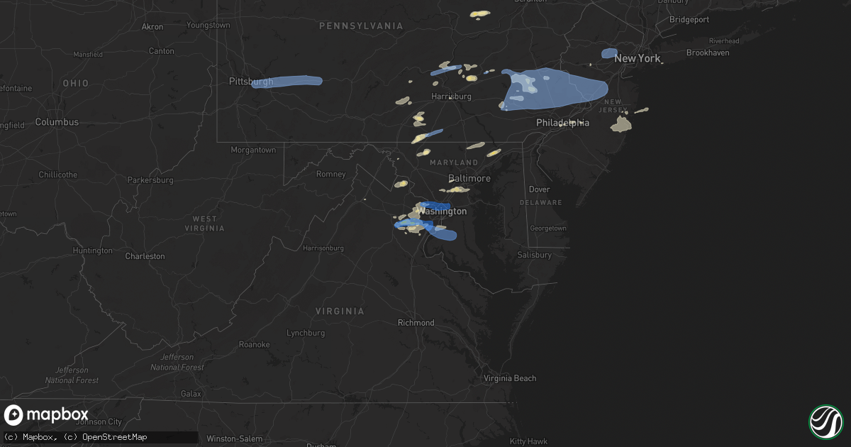
Hail Map in Maryland on May 26, 2021
Get this storm
May 26 map
$229
one time, instant access
Download today. No call, no setup
Keep the $229
Bought the map and want the full workflow? Apply the entire $229 to a subscription within 7 days. None of it is wasted.
Every map, not just this one
This buys you this map. Subscription and you get every map we run, in the markets you choose from a few cities to whole states to nationwide. Plus real-time alerts the moment a storm fires.
Contact data
Name, contact info, occupancy, even credit band for addresses in the footprint. You go from where it hit to who to call.
Become the source they trust
Unlimited branding weather history reports on demand. You already have the documented answer ready for the property owner, and you are the one who showed up with it.
Property data and RoofTrace estimates
Pull up any address you have got, its value and the exact code rules for that jurisdiction, straight from One Click Code. Then RoofTrace estimates the squares, pitch, and roof value, priced the way you price.
Storm reports in Maryland
Maryland
| Date | Description |
|---|---|
| 05/26/20216:55 PM CDT | About a dozen calls for trees and wires down in the sykesville area. |
| 05/26/20216:54 PM CDT | Tree blew down on md 97 south near md 32. |
| 05/26/20216:50 PM CDT | Tree down on livingston road south of medinah ridge road |
| 05/26/20216:45 PM CDT | About a dozen calls for trees and wires down in the mount airy area. |
| 05/26/20216:35 PM CDT | Roof partially blown off barn in the 14000 block of weller road. A couple of trees also blew down. |
| 05/26/20216:13 PM CDT | Powerlines down on the 3000 block of petersville road |
| 05/26/20216:12 PM CDT | Tree blew down on md 478 near moore street. |
| 05/26/20216:00 PM CDT | Tree down on the 9000 block of md-223/piscataway road |
| 05/26/20215:52 PM CDT | Tree blew down on md 273 near lewisville road. |
| 05/26/20215:48 PM CDT | Tree down near the intersection of indian head highway and old fort road south |
| 05/26/20215:25 PM CDT | Numerous trees down between the 1800 and 2000 block of nobles mill road |
| 05/26/20215:03 PM CDT | Tree fell across roadway on furnace rd. |
| 05/26/20214:54 PM CDT | Tree blew down on md 295 south at ridge road. |
| 05/26/20214:46 PM CDT | Partial structure collapse of the frame of a new building under construction in the 3700 block of crain highway. |
| 05/26/20214:44 PM CDT | Tree blew down onto an occupied car in the 10900 block of sweetgum way. Occupant safely out of car. |
| 05/26/20214:44 PM CDT | A local report indicates 1.00 inch wind near 3 W ELKRIDGE |
| 05/26/20214:42 PM CDT | A local report indicates 1.00 inch wind near 3 WSW ELKRIDGE |
| 05/26/20214:42 PM CDT | Tree down on house on the 13000 block of pendleton street |
| 05/26/20214:42 PM CDT | Trees down on 4-5 houses... Several trees on cars... And dozens of trees and wires down in the ft. Washington park area. |
| 05/26/20214:40 PM CDT | Multiple trees blew down in the southern portion of prince george's county near fort washington. |
| 05/26/20214:40 PM CDT | *** 1 inj *** tree down on home in 13300 block of pendleton street in fort washington. |
| 05/26/20214:40 PM CDT | Tree blew down on md 223 north past gallahan road. |
| 05/26/20214:40 PM CDT | *** 1 inj *** tree down on home in 13300 block of pendleton street in fort washington. |
| 05/26/20214:35 PM CDT | Tree blew down on md 210 south at old fort road. |
| 05/26/20214:35 PM CDT | Tree branches and trees down on murray hill road near the middle patuxent river to the intersection of vollmerhausen road. |
| 05/26/20214:30 PM CDT | Large tree branches down across road |
| 05/26/20214:26 PM CDT | Tree blew down onto one lane of us 40 near nuwood drive. |
| 05/26/20214:17 PM CDT | Two trees fell onto two different apartment buildings in the 3000 block of oak green circle. |
| 05/26/20212:59 PM CDT | Tree and wires down near intersection of haughs church road and detour road. |
| 05/26/20214:35 AM CDT | At 935 PM EDT, severe thunderstorms were located along a line extending from near Marlton to 6 miles southwest of Dunkirk to 6 miles east of La Plata, moving east at 35 mph. HAZARD...60 mph wind gusts. SOURCE...Radar indicated. IMPACT...Damaging winds will cause some trees and large branches to fall. This could injure those outdoors, as well as damage homes and vehicles. Roadways may become blocked by downed trees. Localized power outages are possible. Unsecured light objects may become projectiles. Locations impacted include... Chesapeake Ranch Estates, Chesapeake Beach, Deale, Prince Frederick, Sheridan Point, Calvert Cliffs, Hallowing Point, Saint Leonard Creek, Town Creek, Flag Harbor, California, Golden Beach, Dunkirk, Lusby, Saint Leonard, Hollywood, Patuxent River Naval Air Station, Huntingtown, Drum Point and Hughesville. |
| 05/26/20213:53 AM CDT | At 853 PM EDT, a severe thunderstorm was located near Dale City, moving east at 35 mph. HAZARD...60 mph wind gusts. SOURCE...Radar indicated. IMPACT...Damaging winds will cause some trees and large branches to fall. This could injure those outdoors, as well as damage homes and vehicles. Roadways may become blocked by downed trees. Localized power outages are possible. Unsecured light objects may become projectiles. Locations impacted include... Waldorf, Dale City, Clinton, Fort Washington, Fort Hunt, La Plata, Fort Belvoir, Woodbridge, Lake Ridge, Linton Hall, Montclair, Lorton, Newington, Triangle, Dumfries, Saint Charles, Manassas, Cherry Hill, Mount Vernon and Accokeek. |
| 05/26/20212:53 AM CDT | At 752 PM EDT, severe thunderstorms were located along a line extending from Westminster to near Sykesville, moving east at 50 mph. HAZARD...60 mph wind gusts. SOURCE...Radar indicated. IMPACT...Damaging winds will cause some trees and large branches to fall. This could injure those outdoors, as well as damage homes and vehicles. Roadways may become blocked by downed trees. Localized power outages are possible. Unsecured light objects may become projectiles. Locations impacted include... Baltimore, Pikesville, Middle River, Cockeysville, Westminster, Ellicott City, Towson, Woodlawn, Randallstown, Parkville, Owings Mills, Bel Air North, Eldersburg, Carney, Milford Mill, Perry Hall, Reisterstown, Lochearn, Rosedale and Rossville. |
| 05/26/20212:27 AM CDT | At 727 PM EDT, a severe thunderstorm was located over Middleburg, or 11 miles west of Brambleton, moving east at 35 mph. HAZARD...60 mph wind gusts. SOURCE...Radar indicated. IMPACT...Damaging winds will cause some trees and large branches to fall. This could injure those outdoors, as well as damage homes and vehicles. Roadways may become blocked by downed trees. Localized power outages are possible. Unsecured light objects may become projectiles. Locations impacted include... Reston, Leesburg, South Riding, Herndon, Broadlands, Lansdowne, Lowes Island, Brambleton, Dulles International Airport, Ashburn, Sterling, North Potomac, Wolf Trap, Great Falls, Countryside, Middleburg, Arcola, Oatlands, Darnestown and Belmont. |
| 05/26/20212:21 AM CDT | At 721 PM EDT, severe thunderstorms were located along a line extending from Braddock Heights to near Point Of Rocks, moving east at 50 mph. HAZARD...60 mph wind gusts. SOURCE...Radar indicated. IMPACT...Damaging winds will cause some trees and large branches to fall. This could injure those outdoors, as well as damage homes and vehicles. Roadways may become blocked by downed trees. Localized power outages are possible. Unsecured light objects may become projectiles. Locations impacted include... Frederick, Westminster, Damascus, Harry Grove Stadium, Ellicott City, Eldersburg, Ballenger Creek, Mount Airy, Hampstead, Walkersville, Manchester, Sykesville, Oakland, New Market, Green Valley, Gamber, Clover Hill, Discovery-Spring Garden, Linganore-Bartonsville and Clarksburg. |
| 05/26/20211:17 AM CDT | At 617 PM EDT, a severe thunderstorm was located near Bel Air South, or near Aberdeen, moving northeast at 25 mph. HAZARD...60 mph wind gusts. SOURCE...Radar indicated. IMPACT...Damaging winds will cause some trees and large branches to fall. This could injure those outdoors, as well as damage homes and vehicles. Roadways may become blocked by downed trees. Localized power outages are possible. Unsecured light objects may become projectiles. Locations impacted include... Elkton, Aberdeen, Havre De Grace, Aberdeen Proving Ground, Calvert, Bel Air South, Bel Air North, Riverside, North East, Rising Sun, Perryman, Charlestown, Zion, Blake, Barksdale, West Nottingham, Octoraro, Fair Hill, Glen Westover and Bay View. |
| 05/26/202112:52 AM CDT | At 552 PM EDT, severe thunderstorms were located along a line extending from Upper Marlboro to near Waldorf, moving east at 20 mph. HAZARD...60 mph wind gusts. SOURCE...Radar indicated. IMPACT...Damaging winds will cause some trees and large branches to fall. This could injure those outdoors, as well as damage homes and vehicles. Roadways may become blocked by downed trees. Localized power outages are possible. Unsecured light objects may become projectiles. Locations impacted include... Waldorf, Shady Side, Chesapeake Beach, Deale, Prince Frederick, Upper Marlboro, Calvert Cliffs, Breezy Point, Flag Harbor, Rosaryville, Marlton, Dunkirk, Saint Leonard, Saint Charles, Brandywine, Huntingtown, Hughesville, Owings, Baden and Long Beach. |
| 05/26/202112:37 AM CDT | At 537 PM EDT, a severe thunderstorm was located over Mount Vernon, moving east at 35 mph. HAZARD...60 mph wind gusts. SOURCE...Radar indicated. IMPACT...Expect damage to trees, roofs, and siding. Locations impacted include... Quarryville, Wakefield, Kirkwood, Little Britain and Buck. |
| 05/26/202112:37 AM CDT | At 537 PM EDT, a severe thunderstorm was located over Mount Vernon, or 17 miles northwest of Newark, moving east at 40 mph. HAZARD...60 mph wind gusts and penny size hail. SOURCE...Radar indicated. IMPACT...Damage to roofs, siding, trees, and power lines is possible. Locations impacted include... West Chester, Coatesville, Westtown, Downingtown, Kennett Square, Oxford, Parkesburg, West Grove, Homeville, Glen Roy, Cochranville, Mount Vernon, Marshallton, Ladenberg, Kemblesville, North Star, Hockessin, West Goshen, Atglen and South Coatesville. |
| 05/26/202112:26 AM CDT | At 526 PM EDT, severe thunderstorms were located along a line extending from near Ellicott City to Columbia to near Fairland, moving east at 35 mph. HAZARD...60 mph wind gusts. SOURCE...Radar indicated. IMPACT...Damaging winds will cause some trees and large branches to fall. This could injure those outdoors, as well as damage homes and vehicles. Roadways may become blocked by downed trees. Localized power outages are possible. Unsecured light objects may become projectiles. Locations impacted include... Baltimore, Columbia, Severn, Pikesville, Middle River, Elkridge, Riviera Beach, Baltimore-Washington Airport, Fort Smallwood State Park, Sillery Bay, Bodkin Point, Millers Island, North Point State Park, Sparrows Point, Pinehurst, Back River, Historic Ellicott City, Glen Burnie, Ellicott City and Dundalk. |
| 05/26/202112:22 AM CDT | At 522 PM EDT, a severe thunderstorm was located over Dale City, moving east at 30 mph. HAZARD...60 mph wind gusts. SOURCE...Radar indicated. IMPACT...Damaging winds will cause some trees and large branches to fall. This could injure those outdoors, as well as damage homes and vehicles. Roadways may become blocked by downed trees. Localized power outages are possible. Unsecured light objects may become projectiles. Locations impacted include... Dale City, Springfield, Fort Washington, Fort Hunt, Groveton, Fort Belvoir, Woodbridge, Lake Ridge, Burke, Montclair, Lorton, Franconia, Hybla Valley, Newington, Triangle, Dumfries, Manassas, West Springfield, Cherry Hill and Mount Vernon. |
| 05/26/202112:00 AM CDT | At 500 PM EDT, a severe thunderstorm was located over Olney, moving east at 25 mph. HAZARD...60 mph wind gusts. SOURCE...Radar indicated. IMPACT...Damaging winds will cause some trees and large branches to fall. This could injure those outdoors, as well as damage homes and vehicles. Roadways may become blocked by downed trees. Localized power outages are possible. Unsecured light objects may become projectiles. Locations impacted include... Columbia, Severn, Olney, Beltsville, Elkridge, Ellicott City, Aspen Hill, Catonsville, Laurel, Fairland, Redland, Colesville, Fort Meade, Savage-guilford, Rossmoor, Wheaton-Glenmont, Scaggsville, Ilchester, Calverton and Cloverly. |
| 05/25/202110:59 PM CDT | At 358 PM EDT, a severe thunderstorm was located over Point Of Rocks, or 8 miles northwest of Poolesville, moving east at 15 mph. HAZARD...60 mph wind gusts. SOURCE...Radar indicated. IMPACT...Damaging winds will cause some trees and large branches to fall. This could injure those outdoors, as well as damage homes and vehicles. Roadways may become blocked by downed trees. Localized power outages are possible. Unsecured light objects may become projectiles. Locations impacted include... Germantown, Point Of Rocks, Boyds, Clarksburg, Adamstown, Buckeystown, Doubs, Tuscarora, Lucketts, Park Mills and Taylorstown. |
| 05/25/202110:40 PM CDT | At 340 PM EDT, severe thunderstorms were located along a line extending from Purcellville to 7 miles southwest of Berryville, moving east at 20 mph. HAZARD...60 mph wind gusts. SOURCE...Radar indicated. IMPACT...Damaging winds will cause some trees and large branches to fall. This could injure those outdoors, as well as damage homes and vehicles. Roadways may become blocked by downed trees. Localized power outages are possible. Unsecured light objects may become projectiles. Locations impacted include... Leesburg, Lansdowne, Poolesville, Purcellville, Round Hill, Bluemont, Hamilton, Barnesville, Hillsboro, Saint Louis, Paeonian Springs, Gleedsville, Waterford, Lucketts, Wickliffe, Upperville, Dickerson, Beallsville, Philomont and Lincoln. |
| 05/25/202110:21 PM CDT | At 320 PM EDT, severe thunderstorms were located along a line extending from Harpers Ferry to 6 miles southeast of Charles Town, moving northeast at 25 mph. HAZARD...60 mph wind gusts. SOURCE...Radar indicated. IMPACT...Damaging winds will cause some trees and large branches to fall. This could injure those outdoors, as well as damage homes and vehicles. Roadways may become blocked by downed trees. Localized power outages are possible. Unsecured light objects may become projectiles. Locations impacted include... Frederick, Harry Grove Stadium, Ballenger Creek, Brunswick, Braddock Heights, Clover Hill, Point Of Rocks, Adamstown, Jefferson, Lovettsville, Buckeystown, Rosemont, Burkittsville, Hillsboro, Doubs, Clifton, Lucketts, Park Mills, Arnoldtown and Knoxville. |
| 05/25/202110:21 PM CDT | At 320 PM EDT, a severe thunderstorm was located near Winfield, or near Fairmont, moving east at 40 mph. HAZARD...Wind gusts to 60 mph. SOURCE...Radar. IMPACT...Expect damage to trees and power lines, resulting in some power outages. Locations impacted include... Morgantown... Fairmont... Winfield... Brookhaven... Rivesville... Reedsville... Masontown... Brandonville... Bruceton Mills... Valley Point... Everettville... Laurel Run...This includes the following highways... Interstate 68 in West Virginia between mile markers 1 and 7, and between mile markers 11 and 31. Interstate 79 in West Virginia between mile markers 137 and 151. |
| 05/25/20219:51 PM CDT | At 251 PM EDT, a severe thunderstorm was located near Charles Town, moving northeast at 25 mph. HAZARD...60 mph wind gusts. SOURCE...Radar indicated. IMPACT...Damaging winds will cause some trees and large branches to fall. This could injure those outdoors, as well as damage homes and vehicles. Roadways may become blocked by downed trees. Localized power outages are possible. Unsecured light objects may become projectiles. Locations impacted include... Charles Town, Shepherdstown, Brunswick, Ranson, Harpers Ferry, Corporation Of Ranson, Lovettsville, Bolivar, Sharpsburg, Shenandoah Junction, Middleway, Rosemont, Burkittsville, Gapland, Brownsville, Antietam, Petersville, Pleasantville, Millville and Rippon. |
| 05/25/20218:16 PM CDT | Tree blew down on marshall hall road. |
| 05/25/20217:40 PM CDT | Tree blew down on md 4 north near water street. |
| 05/25/20217:33 PM CDT | Wires down near the intersection of walhonding road and tuscarawas road |
| 05/25/20217:30 PM CDT | Tree down at the 4600 block of windsor ave. |
| 05/25/20217:22 PM CDT | Wires down on the 7000 block of wisconsin avenue |
| 05/25/20217:20 PM CDT | Wires down on the 8000 block of maple avenue |
| 05/25/20217:18 PM CDT | Tree and wires down blocking road near the intersection of persimmon tree road and holly leaf lane |
| 05/25/20217:14 PM CDT | Tree down on transformer on 8000 block of block river road |
| 05/25/20217:12 PM CDT | Multiple trees and wires down in the cabin john area. |
| 05/25/20217:03 PM CDT | Tree blew down on md 30 south near kemp road. |
| 05/25/20217:03 PM CDT | 5 trees blew down in the reiserstown/owings mills area. |
All States Impacted by Hail Map on May 26, 2021
Cities Impacted by Hail Map on May 26, 2021
- Geneseo, KS
- Lorraine, KS
- New Cambria, KS
- Gypsum, KS
- Salina, KS
- Solomon, KS
- Clay Center, KS
- Greenleaf, KS
- Woodston, KS
- Linn, KS
- Kirwin, KS
- Green, KS
- Palco, KS
- Agenda, KS
- Alton, KS
- Jewell, KS
- Barnes, KS
- Jamestown, KS
- Damar, KS
- Hill City, KS
- Bogue, KS
- Cuba, KS
- Norway, KS
- Randall, KS
- Morland, KS
- Concordia, KS
- Downs, KS
- Clifton, KS
- Osborne, KS
- Esbon, KS
- Blue Rapids, KS
- Frankfort, KS
- Belleville, KS
- Clyde, KS
- Cawker City, KS
- Morganville, KS
- Waterville, KS
- Palmer, KS
- Randolph, KS
- Plainville, KS
- Beloit, KS
- Scandia, KS
- Mankato, KS
- Haddam, KS
- Portis, KS
- Stockton, KS
- Glen Elder, KS
- Penokee, KS
- Lance Creek, WY
- Lyons, KS
- Lenora, KS
- Ellis, KS
- Gillette, WY
- Upton, WY
- Albin, WY
- Dimmitt, TX
- Springlake, TX
- Earth, TX
- Hart, TX
- Poughquag, NY
- Stormville, NY
- Wappingers Falls, NY
- Poughkeepsie, NY
- Hopewell Junction, NY
- Lagrangeville, NY
- Muleshoe, TX
- Danbury, NE
- Oberlin, KS
- Monahans, TX
- Barstow, TX
- Stockville, NE
- Curtis, NE
- Edgemont, SD
- Thayer, KS
- Hemingford, NE
- Grant, NE
- McCune, KS
- Cozad, NE
- Lexington, NE
- Hays, KS
- Schoenchen, KS
- Ovid, CO
- Keystone, NE
- Holdrege, NE
- Phillipsburg, KS
- Little River, KS
- Windom, KS
- Hoxie, KS
- Benkelman, NE
- Palisade, NE
- Wauneta, NE
- Liebenthal, KS
- Victoria, KS
- Walker, KS
- La Crosse, KS
- Bison, KS
- McCook, NE
- Perryton, TX
- Imperial, NE
- Madrid, NE
- Elsie, NE
- Venango, NE
- Spearman, TX
- Gruver, TX
- Booker, TX
- Balko, OK
- Culbertson, NE
- Funk, NE
- Herndon, KS
- Mcpherson, KS
- Colby, KS
- Levant, KS
- Brewster, KS
- Anselmo, NE
- Arnold, NE
- Stapleton, NE
- Lovettsville, VA
- Waterford, VA
- Purcellville, VA
- Minden, NE
- Loomis, NE
- Crawford, NE
- Atwood, KS
- Kress, TX
- Tulia, TX
- Keymar, MD
- Rocky Ridge, MD
- Brookville, KS
- White Deer, TX
- Panhandle, TX
- Stratton, NE
- Enders, NE
- Trenton, NE
- Hayes Center, NE
- Max, NE
- Fall River, KS
- Canyon, TX
- Amarillo, TX
- Goodland, KS
- Gurley, NE
- Dalton, NE
- Belle Fourche, SD
- Quenemo, KS
- Osage City, KS
- Shippensburg, PA
- Biglerville, PA
- Saugerties, NY
- Russell, KS
- Bunker Hill, KS
- Gorham, KS
- Harveyville, KS
- Sutherland, NE
- Edson, KS
- Selden, KS
- Norcatur, KS
- Amherst, TX
- Fieldton, TX
- Hale Center, TX
- Olton, TX
- Littlefield, TX
- Gardners, PA
- Bechtelsville, PA
- Boyertown, PA
- Gilbertsville, PA
- Jonestown, PA
- Pine Grove, PA
- Annville, PA
- Sterling, CO
- Moorcroft, WY
- Emporia, KS
- Reading, KS
- White City, KS
- Council Grove, KS
- Annapolis Junction, MD
- Hanover, MD
- Savage, MD
- Laurel, MD
- Columbia, MD
- Elkridge, MD
- Jessup, MD
- Julesburg, CO
- Sudan, TX
- Plainview, TX
- Lincolnville, KS
- Marion, KS
- Tatum, NM
- Elwood, NE
- Bridgeport, NE
- Port Royal, PA
- Honey Grove, PA
- Hershey, NE
- Jal, NM
- Broadwater, NE
- Admire, KS
- Beaver, OK
- Hardesty, OK
- Manassas, VA
- Nokesville, VA
- Bristow, VA
- Lincoln, KS
- Ellsworth, KS
- Wilson, KS
- Alma, NE
- Wilsonville, NE
- Maywood, NE
- Almena, KS
- Prairie View, KS
- Oxford, NE
- Long Island, KS
- Bartley, NE
- Smith Center, KS
- Jennings, KS
- Agra, KS
- Moorefield, NE
- Kensington, KS
- Cambridge, NE
- Ludell, KS
- Farnam, NE
- Stamford, NE
- Gaylord, KS
- Logan, KS
- Lebanon, NE
- Clayton, KS
- Indianola, NE
- Glade, KS
- Beaver City, NE
- Norton, KS
- Eustis, NE
- Athol, KS
- Hendley, NE
- Orleans, NE
- Rockville Centre, NY
- Oceanside, NY
- Baldwin, NY
- Ellicott City, MD
- Boonsboro, MD
- Catlett, VA
- Benton, PA
- Harrisburg, NE
- Abernathy, TX
- Unityville, PA
- Millville, PA
- Clinton, MD
- Alexandria, VA
- Fort Washington, MD
- Bryans Road, MD
- Accokeek, MD
- Fort Belvoir, VA
- Hereford, TX
- Claflin, KS
- Holyrood, KS
- Marquette, KS
- Sylvan Grove, KS
- Dorrance, KS
- Waldo, KS
- Bushton, KS
- Hoisington, KS
- Moundridge, KS
- Inman, KS
- Chase, KS
- Canton, KS
- Galva, KS
- Kanopolis, KS
- Goessel, KS
- Gainesville, VA
- Watertown, CT
- Thomaston, CT
- Leesburg, VA
- Pampa, TX
- Merriman, NE
- Gordon, NE
- Bingham, NE
- Ashby, NE
- Wellington, KS
- Clifton, VA
- Lykens, PA
- Hegins, PA
- Valley View, PA
- Sacramento, PA
- Spring Glen, PA
- Tower City, PA
- Williamstown, PA
- Ephrata, PA
- Denver, PA
- Stevens, PA
- New Holland, PA
- Ogallah, KS
- Wakeeney, KS
- Oshkosh, NE
- Hay Springs, NE
- Ellsworth, NE
- Fort Davis, TX
- Fredericksburg, PA
- Pine Bluffs, WY
- Bel Air, MD
- Havre De Grace, MD
- Churchville, MD
- Mayfield, KS
- Fairfield, PA
- Spring Run, PA
- Dry Run, PA
- Newburg, PA
- Amberson, PA
- New Germantown, PA
- Dodge City, KS
- Ensign, KS
- Cimarron, KS
- Rushville, NE
- Chappell, NE
- Lodgepole, NE
- Burlingame, KS
- Lovington, NM
- Meshoppen, PA
- Mehoopany, PA
- Whitney, NE
- Harrison, NE
- Marsland, NE
- Hampton, CT
- Chaplin, CT
- Schuylkill Haven, PA
- Reading, PA
- Bird City, KS
- Chadron, NE
- Stoneham, CO
- Newcastle, WY
- East Earl, PA
- Anton, TX
- Germantown, NY
- Elizaville, NY
- Tivoli, NY
- Douglassville, PA
- Oley, PA
- Hamburg, PA
- Kutztown, PA
- Pottstown, PA
- Mertztown, PA
- Lyon Station, PA
- Fleetwood, PA
- Alburtis, PA
- Perkiomenville, PA
- Frederick, PA
- Barto, PA
- Blandon, PA
- Macungie, PA
- Leesport, PA
- Shoemakersville, PA
- Lakeside, NE
- Alliance, NE
- Skellytown, TX
- Waverly, KS
- Douglas, WY
- Weldona, CO
- Philadelphia, PA
- Camden, NJ
- Shallowater, TX
- McDonald, KS
- Fredonia, KS
- Longton, KS
- Elk City, KS
- Neodesha, KS
- Peetz, CO
- Padroni, CO
- Paxton, NE
- Haymarket, VA
- Broad Run, VA
- Warrenton, VA
- Lemoyne, PA
- Camp Hill, PA
- Morgantown, WV
- Fairmont, WV
- Red Hook, NY
- Brule, NE
- Big Springs, NE
- Champion, NE
- The Plains, VA
- North Platte, NE
- Montezuma, KS
- Durham, KS
- Lost Springs, KS
- Halstead, KS
- Peabody, KS
- Lehigh, KS
- Hesston, KS
- Newton, KS
- Walton, KS
- Roxbury, KS
- Hillsboro, KS
- Ramona, KS
- Tampa, KS
- Lindsborg, KS
- North Newton, KS
- Beverly, KS
- Pfeifer, KS
- Luray, KS
- McCracken, KS
- Lorton, VA
- Springfield, VA
- Reston, VA
- Fairfax Station, VA
- Herndon, VA
- Chantilly, VA
- McLean, VA
- Vienna, VA
- Oakton, VA
- Sterling, VA
- Centreville, VA
- Fairfax, VA
- Woodbridge, VA
- Great Falls, VA
- Catharpin, VA
- Eskridge, KS
- Darlington, MD
- Milan, KS
- Argonia, KS
- Malden On Hudson, NY
- Barrytown, NY
- Fulton, MD
- Severn, MD
- Spencerville, MD
- Harmans, MD
- Glen Burnie, MD
- Burtonsville, MD
- Fort George G Meade, MD
- Ogallala, NE
- Mohnton, PA
- Birdsboro, PA
- Pecos, TX
- Pyote, TX
- Tryon, NE
- Emmitsburg, MD
- Thurmont, MD
- Woodsboro, MD
- Severy, KS
- Eureka, KS
- Piedmont, KS
- Lakewood, NJ
- Newville, PA
- Winona, KS
- Formoso, KS
- Courtland, KS
- Muncy, PA
- Lairdsville, PA
- Port Deposit, MD
- Groom, TX
- Claude, TX
- Coyanosa, TX
- Sabillasville, MD
- Waynesboro, PA
- Gettysburg, PA
- Blue Ridge Summit, PA
- Cascade, MD
- Plains, KS
- Happy, TX
- Shermans Dale, PA
- New Bloomfield, PA
- Duncannon, PA
- Levelland, TX
- Elizabethville, PA
- Halifax, PA
- Americus, KS
- Middletown, DE
- Silverton, TX
- Hot Springs, SD
- Torrington, WY
- Ashton, MD
- Sandy Spring, MD
- Olney, MD
- Silver Spring, MD
- Eddyville, NE
- Dumfries, VA
- Alva, OK
- Burlington, OK
- Altoona, KS
- Laverne, OK
- Benedict, KS
- Howard, KS
- Brick, NJ
- Scranton, KS
- Buffalo, OK
- Leoti, KS
- Bertrand, NE
- Coopersburg, PA
- Quakertown, PA
- Fort Morgan, CO
- Toms River, NJ
- Sidney, NE
- Lyndon, KS
- Hainesport, NJ
- Lumberton, NJ
- Mount Laurel, NJ
- Tescott, KS
- Point Pleasant Beach, NJ
- Whitehouse Station, NJ
- Chanute, KS
- Auburn, KS
- Topeka, KS
- Orrtanna, PA
- Fayetteville, PA
- Stephens City, VA
- Middletown, VA
- Maple Shade, NJ
- Merchantville, NJ
- Riverton, NJ
- Moorestown, NJ
- Cherry Hill, NJ
- Pennsauken, NJ
- Lewellen, NE
- Atlanta, NE
- Street, MD
- Pylesville, MD
- Mentone, TX
- Wakarusa, KS
- Carbondale, KS
- White Hall, MD
- Whiteford, MD
- Parkton, MD
- Beachwood, NJ
- Forked River, NJ
- Manchester Township, NJ
- Bayville, NJ
- Lanoka Harbor, NJ
- Island Heights, NJ
- Pine Beach, NJ
- Millerstown, PA
- Dalmatia, PA
- Liverpool, PA
- Port Trevorton, PA
- Mount Pleasant Mills, PA
- Millersburg, PA
- Jacob, IL
- Gorham, IL
- Nash, OK
- Pond Creek, OK
- Jet, OK
- Cherokee, OK
- Medford, OK
- Arthur, NE
- Lemoyne, NE
- Hildreth, NE
- Wilcox, NE
- Axtell, NE
- Elm Creek, NE
- Overton, NE
- Osage, WY
- Roswell, NM
- Dexter, NM
- Nazareth, TX
- Friona, TX
- Grandfalls, TX
- East Syracuse, NY
- Durhamville, NY
- Fayetteville, NY
- Wampsville, NY
- Jamesville, NY
- Bridgeport, NY
- Verona Beach, NY
- Kirkville, NY
- Rome, NY
- Marcellus, NY
- Auburn, NY
- Minoa, NY
- Verona, NY
- Chittenango, NY
- Canastota, NY
- Oneida, NY
- Cleveland, NY
- Elbridge, NY
- Syracuse, NY
- Skaneateles, NY
- Skaneateles Falls, NY
- Camillus, NY
- West Edmeston, NY
- West Winfield, NY
- Waterville, NY
- Cambridge, NY
- Eagle Bridge, NY
- Arlington, VT
- Shaftsbury, VT
- Shushan, NY
- Buskirk, NY
- North Bennington, VT
- Hoosick Falls, NY
- Manchester Center, VT
- East Arlington, VT
- East Montpelier, VT
- Plainfield, VT
- East Calais, VT
- Adamant, VT
- Granville, VT
- Barre, VT
- Bridport, VT
- North Montpelier, VT
- Ripton, VT
- Danville, VT
- Northfield, VT
- Moretown, VT
- Salisbury, VT
- New Haven, VT
- Montpelier, VT
- Marshfield, VT
- Cabot, VT
- East Ryegate, VT
- Monroe, NH
- Starksboro, VT
- Barnet, VT
- Warren, VT
- Groton, VT
- West Danville, VT
- Waitsfield, VT
- Middlebury, VT
- Bristol, VT
- Roxbury, VT
- Peacham, VT
- Saint Johnsbury, VT
- Cornish, NH
- Windsor, VT
- Brownsville, VT
- Plainfield, NH
- Meriden, NH
- Claremont, NH
- Sunapee, NH
- Charlestown, NH
- Newport, NH
- Wolfeboro, NH
- Moultonborough, NH
- Center Tuftonboro, NH
- Gilford, NH
- Laconia, NH
- Ossipee, NH
- Alton Bay, NH
- Sanbornton, NH
- Meredith, NH
- Mirror Lake, NH
- Occoquan, VA
- Burke, VA
- Mount Rainier, MD
- Washington, DC
- Takoma Park, MD
- Brentwood, MD
- Hyattsville, MD
- Bladensburg, MD
- Cabin John, MD
- Glen Echo, MD
- Riverdale, MD
- Arlington, VA
- Potomac, MD
- Chevy Chase, MD
- College Park, MD
- Bethesda, MD
- Indian Head, MD
- Pomfret, MD
- Waldorf, MD
- White Plains, MD
- Bryantown, MD
- La Plata, MD
- Ellinwood, KS
- Derby, KS
- Goddard, KS
- Andover, KS
- Rose Hill, KS
- Towanda, KS
- Augusta, KS
- Conway Springs, KS
- Benton, KS
- Viola, KS
- Wichita, KS
- Mcconnell Afb, KS
- Clearwater, KS
- Herington, KS
- Burdick, KS
- Toronto, KS
- Buffalo, KS
- Dwight, KS
- Alta Vista, KS
- Ottawa, KS
- Wellsville, KS
- Baldwin City, KS
- Pomona, KS
- Overbrook, KS
- Kersey, CO
- Snyder, CO
- Monument, KS
- Copeland, KS
- Berrysburg, PA
- Newport, PA
- Gratz, PA
- New Oxford, PA
- Slickville, PA
- Duquesne, PA
- Coral, PA
- New Florence, PA
- Vintondale, PA
- North Versailles, PA
- Braddock, PA
- Black Lick, PA
- West Mifflin, PA
- Irwin, PA
- Jeannette, PA
- Seward, PA
- Monroeville, PA
- Turtle Creek, PA
- Robinson, PA
- Johnstown, PA
- Mckeesport, PA
- Armagh, PA
- Dilltown, PA
- Pitcairn, PA
- East Pittsburgh, PA
- Homer City, PA
- Claridge, PA
- East McKeesport, PA
- Harrison City, PA
- Greensburg, PA
- Delmont, PA
- Ardara, PA
- Clarksburg, PA
- Josephine, PA
- Wilmerding, PA
- Export, PA
- Saltsburg, PA
- Trafford, PA
- Pittsburgh, PA
- Blairsville, PA
- Murrysville, PA
- Homestead, PA
- Derry, PA
- New Alexandria, PA
- Short Hills, NJ
- East Hanover, NJ
- Summit, NJ
- Green Village, NJ
- Mendham, NJ
- Morris Plains, NJ
- Whippany, NJ
- Madison, NJ
- Cedar Knolls, NJ
- Morristown, NJ
- New Vernon, NJ
- Livingston, NJ
- Bernardsville, NJ
- Florham Park, NJ
- Basking Ridge, NJ
- Chatham, NJ
- Kingston, NJ
- Center Valley, PA
- Phoenixville, PA
- North Wales, PA
- Ambler, PA
- Glenmoore, PA
- Plymouth Meeting, PA
- Hellertown, PA
- Ottsville, PA
- Robbinsville, NJ
- Topton, PA
- Harleysville, PA
- Breinigsville, PA
- Oaks, PA
- Stockton, NJ
- Montgomeryville, PA
- Temple, PA
- Upper Black Eddy, PA
- Palm, PA
- Lenhartsville, PA
- Franklin Park, NJ
- Trumbauersville, PA
- Green Lane, PA
- Auburn, PA
- North Brunswick, NJ
- Monroe Township, NJ
- Warminster, PA
- Furlong, PA
- Dresher, PA
- Telford, PA
- Titusville, NJ
- Zionsville, PA
- Dayton, NJ
- Monmouth Junction, NJ
- Princeton Junction, NJ
- Adamstown, PA
- Honey Brook, PA
- Blue Bell, PA
- Hatboro, PA
- Souderton, PA
- Lumberville, PA
- Hereford, PA
- Silverdale, PA
- Reinholds, PA
- Royersford, PA
- Lambertville, NJ
- Belle Mead, NJ
- Feasterville Trevose, PA
- Jamison, PA
- Ringoes, NJ
- Fort Washington, PA
- Richlandtown, PA
- Hilltown, PA
- Gwynedd, PA
- Willow Grove, PA
- Dublin, PA
- Hillsborough, NJ
- Trexlertown, PA
- Plainsboro, NJ
- Line Lexington, PA
- Emmaus, PA
- Pipersville, PA
- Schwenksville, PA
- Washington Crossing, PA
- Skillman, NJ
- Cranbury, NJ
- Morrisville, PA
- Terre Hill, PA
- Richboro, PA
- Frenchtown, NJ
- Carversville, PA
- Bally, PA
- Norristown, PA
- Warrington, PA
- Lansdale, PA
- Langhorne, PA
- Pennsburg, PA
- Port Clinton, PA
- Morgantown, PA
- Huntingdon Valley, PA
- Kintnersville, PA
- Sellersville, PA
- Kendall Park, NJ
- Chalfont, PA
- Zieglerville, PA
- Bethlehem, PA
- Colmar, PA
- Mont Clare, PA
- Erwinna, PA
- Flemington, NJ
- Skippack, PA
- Spring City, PA
- Narvon, PA
- Fountainville, PA
- Hatfield, PA
- Riegelsville, PA
- Hightstown, NJ
- East Greenville, PA
- Newtown, PA
- Red Hill, PA
- Lawrence Township, NJ
- Doylestown, PA
- Perkasie, PA
- Rocky Hill, NJ
- Spring House, PA
- Point Pleasant, PA
- Collegeville, PA
- Horsham, PA
- Elverson, PA
- Chester Springs, PA
- Allentown, PA
- Trenton, NJ
- New Hope, PA
- Princeton, NJ
- Pennington, NJ
- Hopewell, NJ
- Southampton, PA


