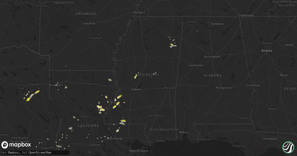
Hail Map in Mississippi on May 21, 2017
Get this storm
May 21 map
$229
one time, instant access
Download today. No call, no setup
Keep the $229
Bought the map and want the full workflow? Apply the entire $229 to a subscription within 7 days. None of it is wasted.
Every map, not just this one
This buys you this map. Subscription and you get every map we run, in the markets you choose from a few cities to whole states to nationwide. Plus real-time alerts the moment a storm fires.
Contact data
Name, contact info, occupancy, even credit band for addresses in the footprint. You go from where it hit to who to call.
Become the source they trust
Unlimited branding weather history reports on demand. You already have the documented answer ready for the property owner, and you are the one who showed up with it.
Property data and RoofTrace estimates
Pull up any address you have got, its value and the exact code rules for that jurisdiction, straight from One Click Code. Then RoofTrace estimates the squares, pitch, and roof value, priced the way you price.
Storm reports in Mississippi
Mississippi
| Date | Description |
|---|---|
| 05/21/20175:53 PM CDT | Trees and power lines down. |
| 05/21/20175:52 PM CDT | A tree was blown down onto highway 11 near the highland subdivision just south of ellisville. |
| 05/21/20175:34 PM CDT | A tree was blown down on highway 588 near river road. |
| 05/21/20175:25 PM CDT | A local report indicates 1.00 inch wind near WREN |
| 05/21/20175:22 PM CDT | A large tree is down across wren cemetary road. Time is radar estimated. |
| 05/21/20174:19 PM CDT | Tree down on gaddis myers rd. |
| 05/21/20174:05 PM CDT | Tree went through a home on kelly circle. |
| 05/21/20173:59 PM CDT | Tree down on cooper rd. |
| 05/21/20173:49 PM CDT | Tree down on sykes ave. |
| 05/21/20173:43 PM CDT | Tree down on dentville rd. |
| 05/21/20173:43 PM CDT | Tree on monticello st. |
| 05/21/20173:39 PM CDT | Tree down on harmony rd. |
| 05/21/20173:39 PM CDT | Tree down on mathis rd. |
| 05/21/20173:39 PM CDT | Tree down on six mile rd. |
| 05/21/20173:38 PM CDT | Tree down on hwy 27. |
| 05/21/20173:34 PM CDT | A local report indicates 1.00 inch wind near 5 N GILLSBERG |
| 05/21/20173:29 PM CDT | Number of trees down north of roxie. |
| 05/21/20173:26 PM CDT | A tree was blown down along ms 27 south of bear creek rd and blocked the northbound lane. |
| 05/21/20173:25 PM CDT | Tree on powerline on tinnin rd. |
| 05/21/20173:12 PM CDT | Several trees were blown down on powerlines along i-20 westbound between bolton and clinton. Report via social media. |
| 05/21/20173:09 PM CDT | Tree down on springridge rd near hwy 18. |
| 05/21/20172:59 PM CDT | Tree on a home on hwy 61. |
| 05/21/20172:59 PM CDT | Tree on a home on hwy 18. |
| 05/21/20172:58 PM CDT | Tree on home on rodney rd. |
| 05/21/20172:56 PM CDT | Tree down on n chapel hill rd. |
| 05/21/20172:46 PM CDT | Tree down on good hope rd. |
| 05/21/20172:43 PM CDT | Trees down on fisher ferry rd. |
| 05/21/20172:40 PM CDT | Tree on hwy 27 near paxton rd. |
| 05/21/20172:40 PM CDT | Tree on nailor rd. |
| 05/21/20172:24 PM CDT | Trees down on hwy 465 near eagle lake rd. |
| 05/21/20172:23 PM CDT | 2 trees on homes on sea island drive. |
| 05/21/20172:21 PM CDT | Roof ripped off a home on eagle lake shore rd. |
All States Impacted by Hail Map on May 21, 2017
Cities Impacted by Hail Map on May 21, 2017
- Laredo, TX
- Leesville, LA
- Stafford, TX
- Bellaire, TX
- Sugar Land, TX
- Houston, TX
- Missouri City, TX
- El Campo, TX
- Port Allen, LA
- Overton, TX
- San Ygnacio, TX
- Shreveport, LA
- Liberty, MS
- Crawford, TX
- Benton, MS
- Bentonia, MS
- Jonesville, LA
- Ferriday, LA
- Springer, NM
- House, NM
- Cuervo, NM
- Dryden, TX
- Vaughan, MS
- Conchas Dam, NM
- Mosquero, NM
- Singer, LA
- Henderson, TX
- Jacksonville, TX
- Reklaw, TX
- Laneville, TX
- Crane, TX
- Zapata, TX
- Roma, TX
- Amory, MS
- Woodville, TX
- Floresville, TX
- Pleasanton, TX
- Nettleton, MS
- Gilbert, LA
- Bossier City, LA
- Starks, LA
- Lake Providence, LA
- Pioneer, LA
- Transylvania, LA
- Lorman, MS
- Fayette, MS
- Clayton, LA
- Port Gibson, MS
- Trementina, NM
- Wagon Mound, NM
- Sinton, TX
- Mirando City, TX
- Slaughter, LA
- Clinton, LA
- Pride, LA
- Zachary, LA
- Rio Grande City, TX
- Hull, TX
- Magnolia, AR
- Ragley, LA
- Goldsmith, TX
- Odessa, TX
- Natchez, MS
- Devine, TX
- Oilton, TX
- Waco, TX
- Elm Mott, TX
- Aberdeen, MS
- Okolona, MS
- Deridder, LA
- Sugartown, LA
- Seadrift, TX
- Monterey, LA
- Wharton, TX
- Baytown, TX
- Beckville, TX
- Pritchett, CO
- Mount Hope, AL
- Boise City, OK
- Greensburg, LA
- Magnolia, MS
- Kountze, TX
- Barksdale Afb, LA
- Sicily Island, LA
- Hallettsville, TX
- Tatum, TX
- Troup, TX
- Carthage, MS
- Harrisonburg, LA
- Vidalia, LA
- Longville, LA
- Woodway, TX
- Valley Mills, TX
- Saint Joseph, LA
- Hackberry, LA
- Eunice, LA
- Oakdale, LA
- China Spring, TX
- Pickens, MS
- Floyd, NM
- Ville Platte, LA
- Arnaudville, LA
- Kenton, OK
- Hebbronville, TX
- Vicksburg, MS
- Pattison, MS
- Abbeville, LA
- Lottie, LA
- Orange, TX
- Krotz Springs, LA
- Rosedale, LA
- Kenedy, TX
- Buna, TX
- Fort Stockton, TX
- Shannon, MS
- Sulphur, LA
- Vinton, LA
- Solano, NM
- Saratoga, TX
- Norwood, LA
- Saint Francisville, LA
- Breaux Bridge, LA
- Saint Martinville, LA
- Elmer, LA
- Hineston, LA
- Pineland, SC
- Heflin, LA
- Sibley, LA
- Dry Creek, LA
- Lake Charles, LA
- Silsbee, TX
- Ringgold, LA
- Jamestown, LA
- Edna, TX
- Tupelo, MS
- Philadelphia, MS
- Kosciusko, MS
- Yoakum, TX
- Menard, TX
- Union Church, MS
- Frierson, LA
- Sour Lake, TX
- Dequincy, LA
- Odem, TX
- Utica, MS
- Big Bend National Park, TX
- Las Vegas, NM
- Garita, NM
- Mcalister, NM
- Rusk, TX


