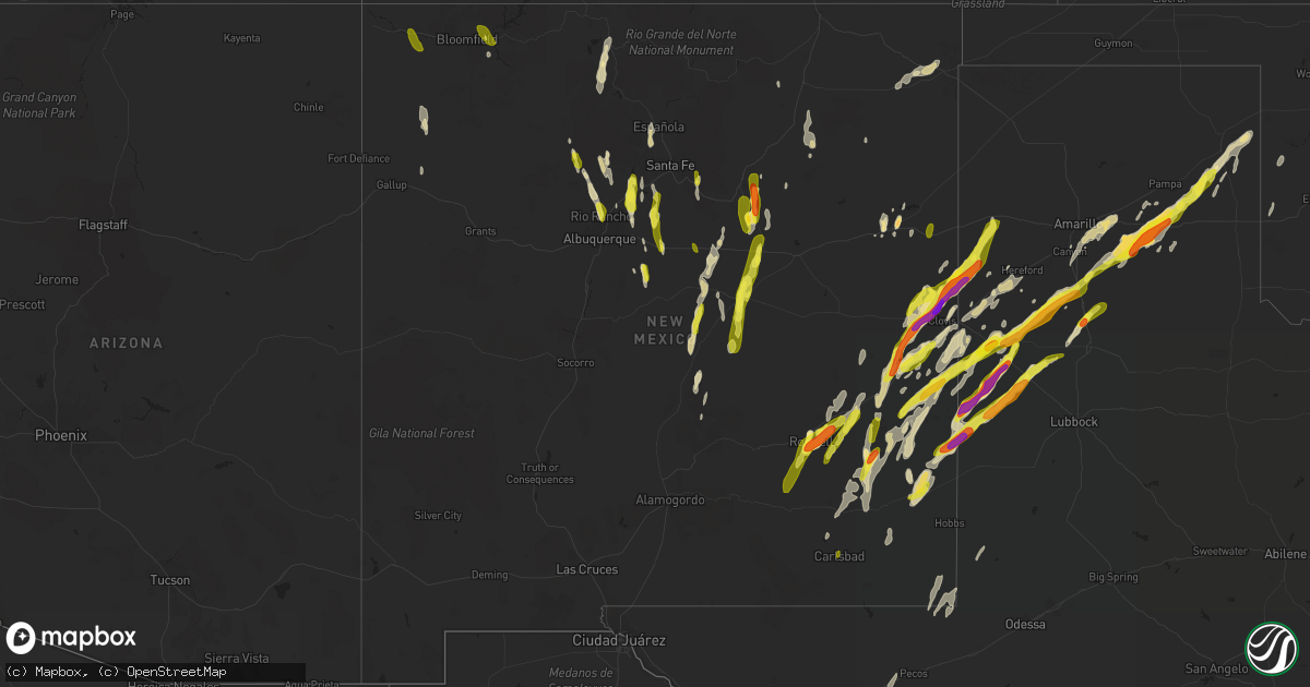
Hail Map in New Mexico on May 9, 2017
Get this storm
May 9 map
$229
one time, instant access
Download today. No call, no setup
Keep the $229
Bought the map and want the full workflow? Apply the entire $229 to a subscription within 7 days. None of it is wasted.
Every map, not just this one
This buys you this map. Subscription and you get every map we run, in the markets you choose from a few cities to whole states to nationwide. Plus real-time alerts the moment a storm fires.
Contact data
Name, contact info, occupancy, even credit band for addresses in the footprint. You go from where it hit to who to call.
Become the source they trust
Unlimited branding weather history reports on demand. You already have the documented answer ready for the property owner, and you are the one who showed up with it.
Property data and RoofTrace estimates
Pull up any address you have got, its value and the exact code rules for that jurisdiction, straight from One Click Code. Then RoofTrace estimates the squares, pitch, and roof value, priced the way you price.
Storm reports in New Mexico
New Mexico
| Date | Description |
|---|---|
| 05/09/20176:54 PM CDT | 2 windows broken out in a residence as well as 2 windshields on vehicles. |
| 05/09/20176:54 PM CDT | A local report indicates 1.00 inch wind near 2 WSW CARLSBAD |
| 05/09/20176:50 PM CDT | A local report indicates 1.25 inch wind near 2 NNW CARLSBAD |
| 05/09/20176:40 PM CDT | Joseph rua. Large hailstones now falling. Started off as 1.25 inches but several 2 plus inch hailstones broke my windshield |
| 05/09/20176:40 PM CDT | A local report indicates 1.50 inch wind near 2 NNW PORTAIR |
| 05/09/20176:28 PM CDT | A local report indicates 2.00 inch wind near CANNON AFB |
| 05/09/20176:25 PM CDT | A local report indicates 1.00 inch wind near CANNON AFB |
| 05/09/20176:15 PM CDT | Tree down over power lines |
| 05/09/20176:14 PM CDT | Kabq asos. |
| 05/09/20175:47 PM CDT | A local report indicates 62 MPH wind near ADELINO |
| 05/09/20175:34 PM CDT | A local report indicates 60 MPH wind near 5 E TOLAR |
| 05/09/20175:30 PM CDT | White sands missile range - mine. |
| 05/09/20175:20 PM CDT | White sands missile range - stallion wit. |
| 05/09/20175:17 PM CDT | A local report indicates 63 MPH wind near SOCORRO |
| 05/09/20175:00 PM CDT | A local report indicates a tornado near 13 NE WAGON MOUND |
| 05/09/20174:10 PM CDT | Quarter sized hail reported by krqe along i-40 near exit 252 |
| 05/09/20174:10 PM CDT | Byron morton reported hail near exit 252 on i-40. |
| 05/09/20173:30 PM CDT | A local report indicates 1.75 inch wind near 6 SSE SAN AUGUSTIN |
| 05/09/20173:00 PM CDT | A local report indicates 1.50 inch wind near 1 NE ANTON CHICO |
| 05/09/20172:30 PM CDT | 1 inch hail lasted from 130 pm to 138 pm mdt. |
| 05/09/20172:22 PM CDT | Nickel to quarter size hail 3 inches deep. |
| 05/09/20172:10 PM CDT | Quarter size hail along cr 502 near el rancho and west of pojoaque... Covering roadway. |
| 05/09/20172:00 PM CDT | A local report indicates a tornado near 7 NE ANCHO |
| 05/09/20171:56 PM CDT | Brief tornado reported nw of clines corners dot |
| 05/09/20171:55 PM CDT | A local report indicates a tornado near 8 NNE NOGAL |
| 05/09/20171:24 PM CDT | Winds snapped off a 6 inch diameter tree branch in yard |
| 05/09/20171:15 PM CDT | 1.00 inch hail lasted for 1 minute. |
| 05/09/20171:15 PM CDT | Tornado touched down just south of i-40 at 1215 pm. Crossed the interstate and lifted up at 1216 pm mdt. Trees uprooted. |
| 05/09/201712:10 PM CDT | A local report indicates 1.00 inch wind near 7 NE TAJIQUE |
| 05/09/201712:10 PM CDT | A local report indicates 1.00 inch wind near 2 NE SAN FELIPE PUEBLO |
| 05/09/201711:56 AM CDT | A local report indicates 1.00 inch wind near MORIARTY |
| 05/09/20177:30 AM CDT | A local report indicates 1.00 inch wind near 7 W FRUITLAND |
| 05/09/20172:18 AM CDT | A local report indicates 60 MPH wind near 5 NNE SEDAN |
| 05/09/201712:45 AM CDT | A local report indicates 1.00 inch wind near 2 SW PORTALES |
| 05/09/201712:03 AM CDT | A local report indicates 1.00 inch wind near 3 NW ROSWELL |
| 05/09/201712:00 AM CDT | A local report indicates 1.00 inch wind near 3 SW PORTALES |
| 05/08/201711:33 PM CDT | Storm chaser reports numerous drifts of 1 hail covering nm hwy 458 |
| 05/08/201711:30 PM CDT | White sands missile range - mine. |
| 05/08/201711:20 PM CDT | White sands missile range - stallion wit. |
| 05/08/201710:20 PM CDT | Ne roswell |
| 05/08/20179:55 PM CDT | 1 hail on alameda in roswell. |
| 05/08/20179:54 PM CDT | A local report indicates 1.25 inch wind near 2 N ROSWELL |
| 05/08/20179:45 PM CDT | Quarter size hail in roswell. Grond is covered by hail. |
| 05/08/20179:45 PM CDT | Ping pong size hail reported at matthews and virginia in roswell. |
| 05/08/20179:45 PM CDT | Golfball size hail estimated in western roswell. |
| 05/08/20178:13 PM CDT | A local report indicates 60 MPH wind near 5 NNE SEDAN |
| 05/08/20178:12 PM CDT | Kcao asos. |
| 05/08/20178:07 PM CDT | Very gusty winds of 60-70 mph estimated. |
| 05/08/20178:00 PM CDT | Small tree limbs down less than 2 in diameter. |
| 05/08/20177:00 PM CDT | A local report indicates 1.25 inch wind near 10 NW PLEASANT HILL |
| 05/08/20177:00 PM CDT | Tornado start time 0555 mdt. Confirmed tornado 9 miles ne of ranchvale or 11 miles n of clovis moving ne at 30 mph. |
All States Impacted by Hail Map on May 9, 2017
Cities Impacted by Hail Map on May 9, 2017
- Roswell, NM
- Sheridan Lake, CO
- Eads, CO
- Kanorado, KS
- Corona, NM
- Gallup, NM
- Morton, TX
- Amherst, TX
- Pep, TX
- Tatum, NM
- Whiteface, TX
- Sudan, TX
- Muleshoe, TX
- Enochs, TX
- Littlefield, TX
- Levelland, TX
- Fieldton, TX
- Elida, NM
- Portales, NM
- Clovis, NM
- Arapahoe, CO
- Tucumcari, NM
- Milnesand, NM
- Crossroads, NM
- Happy, TX
- Hart, TX
- Floyd, NM
- Doniphan, NE
- Selden, KS
- Oberlin, KS
- Farwell, TX
- Bovina, TX
- Las Vegas, NM
- Inavale, NE
- Blue Hill, NE
- Red Cloud, NE
- Brewster, KS
- Canadian, TX
- Naponee, NE
- Erick, OK
- Riverton, NE
- Bladen, NE
- Campbell, NE
- Atwood, KS
- Estancia, NM
- Friona, TX
- Hereford, TX
- Summerfield, TX
- Sharon Springs, KS
- Texico, NM
- Wallace, KS
- Edson, KS
- Goodland, KS
- Sugar City, CO
- Stanley, NM
- Dimmitt, TX
- Nazareth, TX
- Phillips, NE
- Moriarty, NM
- Algodones, NM
- Bethune, CO
- Bird City, KS
- Burlington, CO
- Saint Francis, KS
- Ponderosa, NM
- Clarendon, TX
- Canyon, TX
- San Ysidro, NM
- Weskan, KS
- Rocky Ford, CO
- Rio Rancho, NM
- Corrales, NM
- Hanna, WY
- Amarillo, TX
- Cerrillos, NM
- Santa Fe, NM
- Pampa, TX
- Blanco, NM
- Mobeetie, TX
- Wheeler, TX
- Panhandle, TX
- Claude, TX
- Wagon Mound, NM
- Crawford, OK
- Reydon, OK
- Sandia Park, NM
- Tulia, TX
- Plainview, TX
- Kress, TX
- Oxford, NE
- Phillipsburg, KS
- Agra, KS
- Carleton, NE
- Davenport, NE
- Colby, KS
- Hobbs, NM
- McDonald, KS
- Santo Domingo Pueblo, NM
- Pena Blanca, NM
- Lovington, NM
- Mcdonald, NM
- Las Animas, CO
- Placitas, NM
- Glade Spring, VA
- Pecos, NM
- Vaughn, NM
- Tohatchi, NM
- Shiprock, NM
- Lamar, CO
- Miami, TX
- Groom, TX
- Cimarron, NM
- Ribera, NM
- San Jose, NM
- Lexington, NE
- Jemez Pueblo, NM
- Lewis, IA
- Griswold, IA
- Atlantic, IA
- Grenville, NM
- Ordway, CO
- Santa Rosa, NM
- Smith Center, KS
- Casper, WY
- Tierra Amarilla, NM
- Trementina, NM
- Bloomington, NE
- Elwood, NE
- Levant, KS
- Gem, KS
- Encino, NM
- Gallina, NM
- Rogers, NM
- Pep, NM
- Oak, NE
- Nelson, NE
- Kensington, KS
- Herndon, KS
- Kim, CO
- Capitan, NM
- Meadowview, VA
- Damascus, VA
- Trumbull, NE
- La Loma, NM
- Anton Chico, NM
- Edgewood, NM
- Broadview, NM
- Hagerman, NM
- Earth, TX
- Cheyenne Wells, CO
- Grady, NM
- Artesia, NM
- Bertrand, NE
- Manzanola, CO
- Hastings, NE
- Jal, NM
- Edgar, NE
- Guide Rock, NE
- Melrose, NM
- Springlake, TX
- Causey, NM
- Andrews, TX
- Kermit, TX
- Republican City, NE
- Trinchera, CO
- Jemez Springs, NM
- Conchas Dam, NM
- Clayton, NM
- Carrizozo, NM
- White Deer, TX
- Tobias, NE
- Espanola, NM
- Hale Center, TX
- Wayside, TX
- Briscoe, TX
- Olton, TX
- Maple, TX
- Pecos, TX
- Glorieta, NM
- Ohiowa, NE
- Mosquero, NM
- Grand Island, NE
- Aurora, NE
- Karval, CO
- Farmington, NM
- Waterflow, NM
- Aztec, NM
- Bloomfield, NM
- Tererro, NM
- Dexter, NM
- Adrian, TX
- Carlsbad, NM
- San Jon, NM


