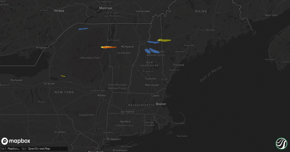
Hail Map in Vermont on October 10, 2020
Get this storm
October 10 map
$229
one time, instant access
Download today. No call, no setup
Keep the $229
Bought the map and want the full workflow? Apply the entire $229 to a subscription within 7 days. None of it is wasted.
Every map, not just this one
This buys you this map. Subscription and you get every map we run, in the markets you choose from a few cities to whole states to nationwide. Plus real-time alerts the moment a storm fires.
Contact data
Name, contact info, occupancy, even credit band for addresses in the footprint. You go from where it hit to who to call.
Become the source they trust
Unlimited branding weather history reports on demand. You already have the documented answer ready for the property owner, and you are the one who showed up with it.
Property data and RoofTrace estimates
Pull up any address you have got, its value and the exact code rules for that jurisdiction, straight from One Click Code. Then RoofTrace estimates the squares, pitch, and roof value, priced the way you price.
Storm reports in Vermont
Vermont
| Date | Description |
|---|---|
| 10/10/20205:58 PM CDT | Trees downed. |
| 10/10/20205:54 PM CDT | Trees down on powerlines |
| 10/10/20205:46 PM CDT | Trees down on powerlines |
| 10/10/20205:42 PM CDT | Trees down on powerlines |
| 10/10/20205:14 PM CDT | Tree down across road |
| 10/10/20205:05 PM CDT | Tree down on wires |
| 10/10/20204:58 PM CDT | Trees down on powerlines |
| 10/10/20204:42 PM CDT | Trees down on powerlines |
| 10/10/20201:48 AM CDT | At 648 PM EDT, a severe thunderstorm was located 9 miles northwest of Littleton, moving east at 55 mph. HAZARD...60 mph wind gusts and quarter size hail. SOURCE...Radar indicated. IMPACT...Hail damage to vehicles is expected. Expect wind damage to roofs, siding, and trees. Locations impacted include... Berlin, Littleton, Lancaster, Bethlehem, Pinkham Notch, Mount Washington, Carroll, Gorham, Jefferson, Dalton, Whitefield, Milan, Shelburne, Randolph, Northumberland and Stark.This also includes... Mount Jefferson, Mount Madison, Moose Brook State Park, MountAdams, and AMC Lake of the Clouds Hut. |
| 10/10/20201:43 AM CDT | At 643 PM EDT, a severe thunderstorm was located over Concord Corner, moving east at 45 mph. HAZARD...60 mph wind gusts and quarter size hail. SOURCE...Radar indicated. IMPACT...Minor hail damage to vehicles is possible. Expect wind damage to trees and powerlines. Locations impacted include... St. Johnsbury, Lyndon, Guildhall, Waterford, Lyndonville Village, Gilman, Kirby, Victory, Concord, Lunenburg, Lower Waterford, Barnet, Granby, St. Johnsbury Center, Concord Corner, West Waterford, Lyndon Center, South Kirby, South Lunenburg and East St. Johnsbury. |
| 10/09/202011:06 PM CDT | At 406 PM EDT, severe thunderstorms were located along a line extending from 18 miles northwest of Pittsburg to 6 miles north of Colebrook to 13 miles northwest of Stratford, moving east at 60 mph. HAZARD...60 mph wind gusts. SOURCE...Radar indicated. IMPACT...Expect damage to roofs, siding, and trees. Locations impacted include... Colebrook, Rangeley, Pittsburg, Dixville, Columbia, Clarksville, Upper Cupsuptic, Adamstown, Oxbow, Parkertown, Lynchtown, Parmachenee, Bowmantown, Lincoln Plantation, Lower Cupsuptic, Stewartstown, Wentworth Location, Magalloway Plantation and Richardsontown.This also includes... First Connecticut Lake, Dixville Notch State Park, Coleman StatePark, Lake Francis State Park, and Magalloway Mountain. |
| 10/09/20209:13 PM CDT | At 212 PM EDT, a severe thunderstorm was located over Brainardsville, moving east at 50 mph. HAZARD...60 mph wind gusts and nickel size hail. SOURCE...Radar indicated. IMPACT...Expect damage to trees and powerlines. Locations impacted include... Chazy, Mooers, Altona, Alburgh Village, Ellenburg Depot, Champlain, Burke, Churubusco, Swanton, South Alburgh, Alburgh, Alburgh Dunes State Park, Swanton Village, Highgate Falls, Isle La Motte, Merrill, Chateaugay, Rouses Point, Highgate and Sheldon. |
Cities Impacted by Hail Map on October 10, 2020
- Westport, NY
- Lewis, NY
- Elizabethtown, NY
- Crowell, TX
- New Russia, NY
- Keene, NY
- Ferrisburgh, VT
- Essex, NY
- Milan, NH
- Gorham, NH
- Berlin, NH
- Chillicothe, TX
- Quanah, TX
- Taberg, NY
- Rome, NY
- Lee Center, NY
- Bristol, VT
- North Ferrisburgh, VT
- Keene Valley, NY
- New Haven, VT
- Vergennes, VT
- Newry, ME
- Bryant Pond, ME
- Bethel, ME
- Rumford, ME
- North Bangor, NY
- Moira, NY
- Brasher Falls, NY
- North Lawrence, NY
- Brushton, NY
- Yatesville, GA
- Butler, GA
- Thomaston, GA
- Culloden, GA
- Williamson, GA
- Concord, GA
- Rockmart, GA
- Cedartown, GA
- Rome, GA
- Adairsville, GA
- Plainville, GA
- Kingston, GA
- Taylorsville, GA
- Calhoun, GA
- Covington, GA
- Morrow, GA
- Newnan, GA
- Decatur, GA
- Stone Mountain, GA
- Whitefield, NH
- Lancaster, NH
- Jefferson, NH
- Randolph, NH
- Lincoln, NH
- Franconia, NH
- Bartlett, NH
- North Conway, NH
- Glen, NH


