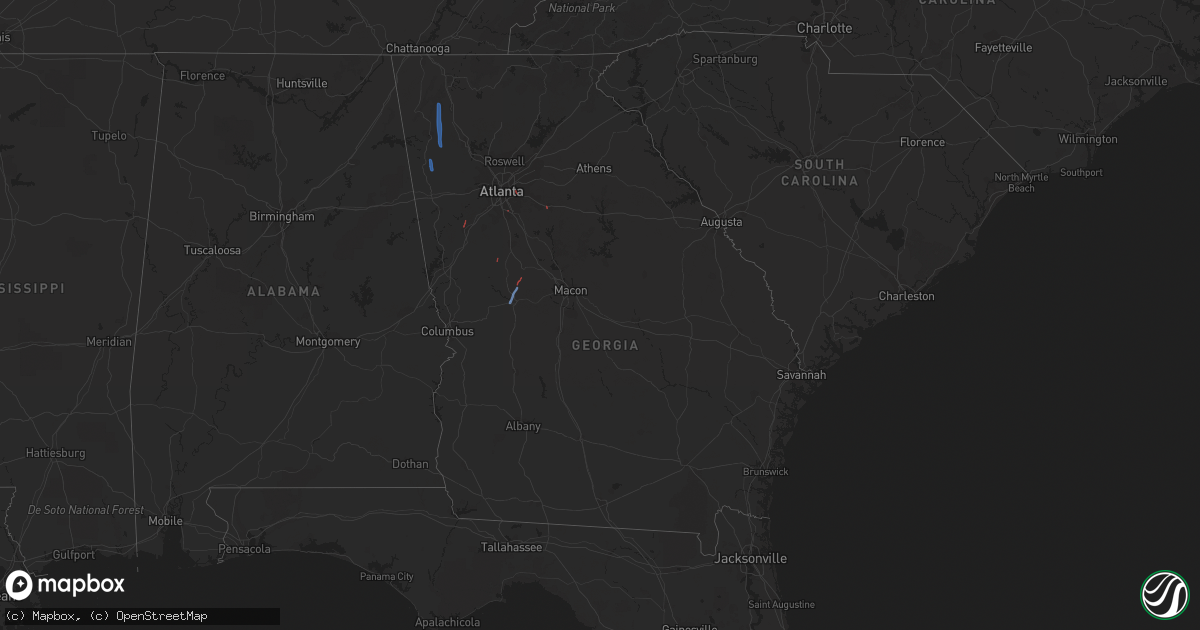
Hail Map in Georgia on October 10, 2020
Get this storm
October 10 map
$229
one time, instant access
Download today. No call, no setup
Keep the $229
Bought the map and want the full workflow? Apply the entire $229 to a subscription within 7 days. None of it is wasted.
Every map, not just this one
This buys you this map. Subscription and you get every map we run, in the markets you choose from a few cities to whole states to nationwide. Plus real-time alerts the moment a storm fires.
Contact data
Name, contact info, occupancy, even credit band for addresses in the footprint. You go from where it hit to who to call.
Become the source they trust
Unlimited branding weather history reports on demand. You already have the documented answer ready for the property owner, and you are the one who showed up with it.
Property data and RoofTrace estimates
Pull up any address you have got, its value and the exact code rules for that jurisdiction, straight from One Click Code. Then RoofTrace estimates the squares, pitch, and roof value, priced the way you price.
Storm reports in Georgia
Georgia
| Date | Description |
|---|---|
| 10/10/20206:45 PM CDT | A very brief tornado touched down near maddox road... South of mt. Zion boulevard between morrow and allendale heights in northeast clayton county. The tornado moved no |
| 10/10/20206:45 PM CDT | Tree reported down on a home on the 6600 block of morrow rd. No injuries or major damage. |
| 10/10/20206:33 PM CDT | Powerlines reported down at the 200 block of church st. |
| 10/10/20206:28 PM CDT | Tree reported down on north blanche ave. |
| 10/10/20206:25 PM CDT | Tree reported down at the intersection of e main st and s broad st. |
| 10/10/20205:53 PM CDT | Two trees were reported down near the intersection of hightower falls rd and wood fall rd. |
| 10/10/20205:28 PM CDT | Multiple trees down near the 800th block of bottoms road extending across to west rd. |
| 10/10/20205:25 PM CDT | Two trees reported down... With one causing damage to corner of a home's roof and porch at the 800 block of happy valley cir. Possible tornado. |
| 10/10/20205:23 PM CDT | Trees reported down north of hwy 27 and hwy 100. |
| 10/10/20205:22 PM CDT | Trees down across howard hughes rd making it impassable. |
| 10/10/20205:22 PM CDT | Newnan highschool sustained structural damage from the result of a tornado. |
| 10/10/20205:12 PM CDT | Tree down at panther creek road and strickland town road. |
| 10/10/20205:06 PM CDT | Tree down on the covered bridge along covered bridge road. |
| 10/10/20203:30 PM CDT | *** 2 inj *** a confirmed ef1 tornado tracked from the intersection of washington st sw and walker bend pkwy to woodhaven dr causing tree and structural damage along it |
| 10/10/20203:09 PM CDT | *** 2 inj *** a tornado tracked from the intersection of washing st sw and flat shoals road to turner lake circle causing tree and structural damage along its path. |
| 10/10/20202:26 AM CDT | At 726 PM EDT, a severe thunderstorm was located near Rome, moving north at 35 mph. HAZARD...60 mph wind gusts. SOURCE...Radar indicated. IMPACT...Expect damage to roofs, siding, and trees. Locations impacted include... Rome, Calhoun, Adairsville, Kingston, Plainville, Shannon, Pinson, Oostanaula, Tidings, Armuchee, Everett Springs and Lindale. |
| 10/10/20201:44 AM CDT | At 644 PM EDT, a severe thunderstorm was located over Antioch, or near Cedartown, moving north at 50 mph. HAZARD...60 mph wind gusts. SOURCE...Radar indicated. IMPACT...Expect damage to roofs, siding, and trees. Locations impacted include... Rome, Cedartown, Rockmart, Aragon, Cave Spring, Seney, Fish Creek, Felton, Lindale, Eubank Lake and Antioch. |
| 10/09/20207:51 PM CDT | Trees down near crescent drive and tanglewood drive. |
| 10/09/20207:45 PM CDT | Building sustained damage to a metal roof on the 4100 block of five forks trickum rd sw. Power outage in the building. |
| 10/09/20207:42 PM CDT | Multiple trees down along the 3500th block of lawrenceville hwy. |
| 10/09/20207:42 PM CDT | Multiple trees down along the 3500th block of lawrenceville hwy. |
| 10/09/20207:13 PM CDT | Four large trees were reported down along oak valley road south of glenwood rd. |
Cities Impacted by Hail Map on October 10, 2020
- Westport, NY
- Lewis, NY
- Elizabethtown, NY
- Crowell, TX
- New Russia, NY
- Keene, NY
- Ferrisburgh, VT
- Essex, NY
- Milan, NH
- Gorham, NH
- Berlin, NH
- Chillicothe, TX
- Quanah, TX
- Taberg, NY
- Rome, NY
- Lee Center, NY
- Bristol, VT
- North Ferrisburgh, VT
- Keene Valley, NY
- New Haven, VT
- Vergennes, VT
- Newry, ME
- Bryant Pond, ME
- Bethel, ME
- Rumford, ME
- North Bangor, NY
- Moira, NY
- Brasher Falls, NY
- North Lawrence, NY
- Brushton, NY
- Yatesville, GA
- Butler, GA
- Thomaston, GA
- Culloden, GA
- Williamson, GA
- Concord, GA
- Rockmart, GA
- Cedartown, GA
- Rome, GA
- Adairsville, GA
- Plainville, GA
- Kingston, GA
- Taylorsville, GA
- Calhoun, GA
- Covington, GA
- Morrow, GA
- Newnan, GA
- Decatur, GA
- Stone Mountain, GA
- Whitefield, NH
- Lancaster, NH
- Jefferson, NH
- Randolph, NH
- Lincoln, NH
- Franconia, NH
- Bartlett, NH
- North Conway, NH
- Glen, NH


