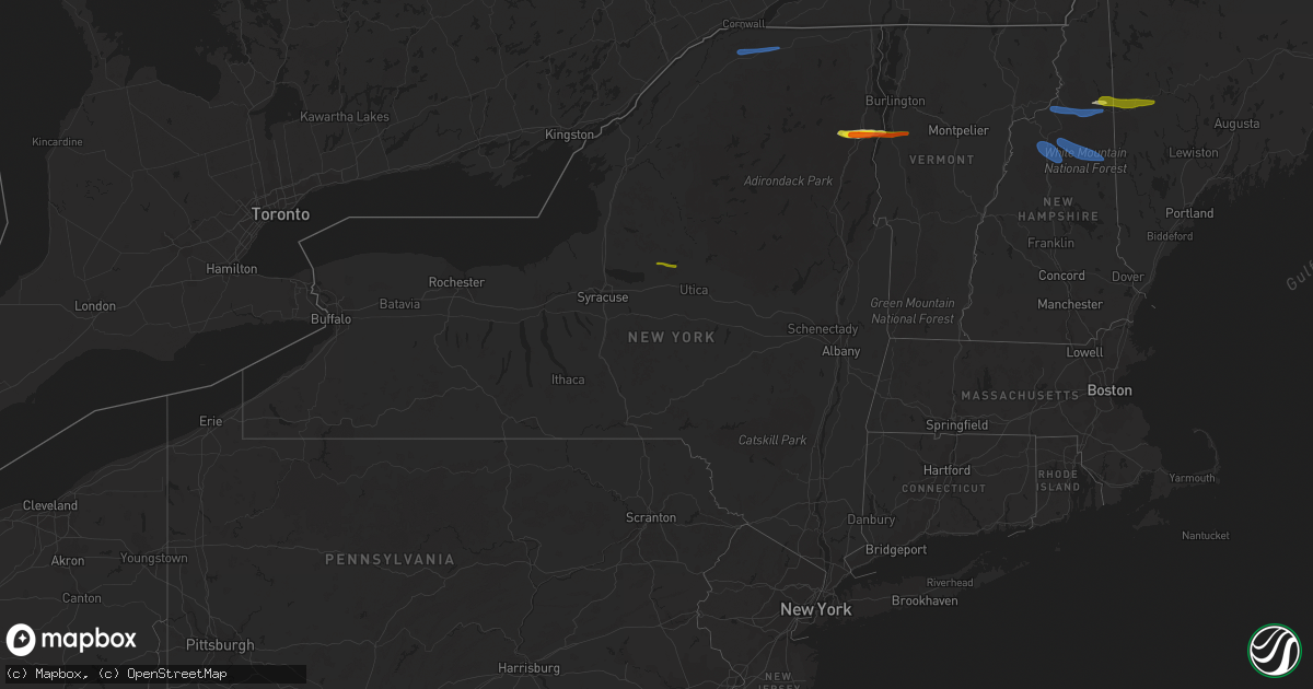
Hail Map in New York on October 10, 2020
Get this storm
October 10 map
$229
one time, instant access
Download today. No call, no setup
Keep the $229
Bought the map and want the full workflow? Apply the entire $229 to a subscription within 7 days. None of it is wasted.
Every map, not just this one
This buys you this map. Subscription and you get every map we run, in the markets you choose from a few cities to whole states to nationwide. Plus real-time alerts the moment a storm fires.
Contact data
Name, contact info, occupancy, even credit band for addresses in the footprint. You go from where it hit to who to call.
Become the source they trust
Unlimited branding weather history reports on demand. You already have the documented answer ready for the property owner, and you are the one who showed up with it.
Property data and RoofTrace estimates
Pull up any address you have got, its value and the exact code rules for that jurisdiction, straight from One Click Code. Then RoofTrace estimates the squares, pitch, and roof value, priced the way you price.
Storm reports in New York
New York
| Date | Description |
|---|---|
| 10/10/20204:40 PM CDT | A local report indicates 1.75 inch wind near ELIZABETHTOWN |
| 10/10/20204:28 PM CDT | Tree down on power lines. |
| 10/10/20204:27 PM CDT | Trees and wires down. Wires on fire near trailer park. |
| 10/10/20204:27 PM CDT | Trees and wires across road |
| 10/10/20202:30 PM CDT | Tree and powerline down |
| 10/10/20202:20 PM CDT | Tree fell onto telephone pole. |
| 10/10/20202:20 PM CDT | Power pole knocked down |
| 10/10/20201:41 PM CDT | Multiple trees down. |
| 10/10/20201:08 AM CDT | At 607 PM EDT, a severe thunderstorm was located near Stratford, or 10 miles north of Little Falls, moving east at 40 mph. HAZARD...60 mph wind gusts and quarter size hail. SOURCE...Radar indicated. IMPACT...Hail damage to vehicles is expected. Expect wind damage to roofs, siding, and trees. Locations impacted include... Gloversville, Johnstown, Dolgeville, Stratford, Caroga Lake Public Campground, Caroga Lake, Oppenheim, Fairfield, Berkshire, Bleecker, Arietta, Meco, Curtis, Pinnacle, Lotville, Rasbach Corner, Knappville, Burrell Corners, Fical Corners and Shedd Corners. |
| 10/10/202012:37 AM CDT | At 537 PM EDT, a severe thunderstorm was located near Steuben, or 9 miles northeast of Rome, moving east at 40 mph. HAZARD...60 mph wind gusts and quarter size hail. SOURCE...Radar indicated. IMPACT...Hail damage to vehicles is expected. Expect wind damage to roofs, siding, and trees. Locations impacted include... Ohio, Newport, Stratford, Poland, Cold Brook, Northwood, Russia, Norway, Oregon, Curtis, Farrel Corner, Clockmill Corners, Lotville, Doxtater Corner, Knappville, Burrell Corners, Wilmurt Corners, Shedd Corners, Morehouseville and Hurricane. |
| 10/10/202012:23 AM CDT | At 522 PM EDT, a severe thunderstorm was located over Keene, moving east at 60 mph. HAZARD...60 mph wind gusts and quarter size hail. SOURCE...Radar indicated. IMPACT...Minor hail damage to vehicles is possible. Expect wind damage to trees and powerlines. Locations impacted include... Vergennes, Lake Placid, Essex, Westport, Elizabethtown, Keene, Monkton Ridge, Waterbury Village, Lincoln, Monkton, Monkton Boro, New Haven, Middlesex, Hinesburg, Moretown, Starksboro, Ferrisburg, Charlotte, Waltham and Bristol. |
| 10/10/202012:21 AM CDT | At 521 PM EDT, a severe thunderstorm was located over Hatch Point, moving east at 45 mph. HAZARD...60 mph wind gusts. SOURCE...Radar indicated. IMPACT...Expect damage to trees and powerlines. Locations impacted include... Essex Junction, South Burlington, Burlington International Airport, Burlington, Montpelier, Willsboro, Winooski, Stowe, Waterbury Village, Essex Junction Village, Williston, Worcester, Middlesex, Bolton, Richmond, Jericho, St. George, Jericho Village, Waterbury and Shelburne. |
| 10/10/202012:18 AM CDT | At 518 PM EDT, a severe thunderstorm was located over Lee, or near Rome, moving east at 55 mph. HAZARD...60 mph wind gusts and quarter size hail. SOURCE...Radar indicated. IMPACT...Hail damage to vehicles is expected. Expect wind damage to roofs, siding, and trees. Locations impacted include... Rome, Lee, Vienna, Trenton, Floyd, Camden, Oriskany, Steuben, Remsen and Holland Patent. |
| 10/09/20209:26 PM CDT | At 226 PM EDT, a severe thunderstorm was located over Nicholville, moving east at 65 mph. HAZARD...60 mph wind gusts and nickel size hail. SOURCE...Radar indicated. IMPACT...Expect damage to trees and powerlines. Locations impacted include... Plattsburgh, Beekmantown, Chazy, Altona, Franklin, Sheldon, Georgia, Grand Isle, St. Albans Town, South Alburgh, Alburgh, Alburgh Dunes State Park, North Hero, Bakersfield, Isle La Motte, Merrill, Lake Carmi State Park, Dannemora, Highgate and Georgia Center. |
Cities Impacted by Hail Map on October 10, 2020
- Westport, NY
- Lewis, NY
- Elizabethtown, NY
- Crowell, TX
- New Russia, NY
- Keene, NY
- Ferrisburgh, VT
- Essex, NY
- Milan, NH
- Gorham, NH
- Berlin, NH
- Chillicothe, TX
- Quanah, TX
- Taberg, NY
- Rome, NY
- Lee Center, NY
- Bristol, VT
- North Ferrisburgh, VT
- Keene Valley, NY
- New Haven, VT
- Vergennes, VT
- Newry, ME
- Bryant Pond, ME
- Bethel, ME
- Rumford, ME
- North Bangor, NY
- Moira, NY
- Brasher Falls, NY
- North Lawrence, NY
- Brushton, NY
- Yatesville, GA
- Butler, GA
- Thomaston, GA
- Culloden, GA
- Williamson, GA
- Concord, GA
- Rockmart, GA
- Cedartown, GA
- Rome, GA
- Adairsville, GA
- Plainville, GA
- Kingston, GA
- Taylorsville, GA
- Calhoun, GA
- Covington, GA
- Morrow, GA
- Newnan, GA
- Decatur, GA
- Stone Mountain, GA
- Whitefield, NH
- Lancaster, NH
- Jefferson, NH
- Randolph, NH
- Lincoln, NH
- Franconia, NH
- Bartlett, NH
- North Conway, NH
- Glen, NH


