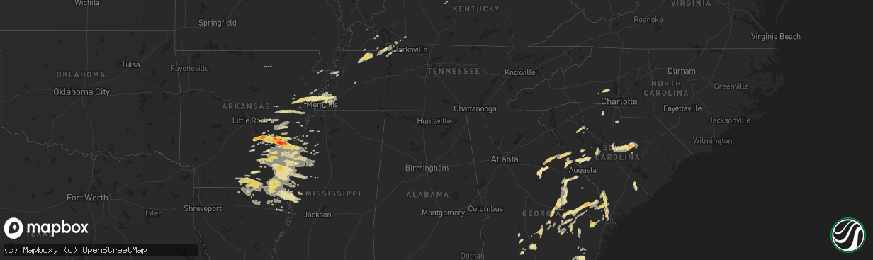
Hail Map in Mississippi on September 25, 2011
The weather event in Mississippi on September 25, 2011 includes Hail map. 15 states and 431 cities were impacted and suffered possible damage. The total estimated number of properties impacted is 0.
Want more than just the map?
Turn this storm into a full workflow.
- Owner + property data so you know who to knock
- OnDemand branded weather history reports to win the "did we even have hail?" argument
- RoofTrace estimate so reps stop guessing numbers at the door
Bought this map? Upgrade within 7 days and we'll credit the $230. (10-15 min setup call)
Hail
0
Estimated number of impacted properties by a 1.00" hail or larger0
Estimated number of impacted properties by a 1.75" hail or larger0
Estimated number of impacted properties by a 2.50" hail or largerStorm reports in Mississippi
Mississippi
| Date | Description |
|---|---|
| 09/24/201111:15 PM CDT | Trees and limbs reported down just west of the county line. Funnel cloud spotted in the vicinity at that time |
| 09/24/201110:10 PM CDT | Power lines down across hwy 12 near the washington/humphreys co line |
| 09/24/20119:05 PM CDT | A local report indicates 1.00 inch wind near SHAW |
| 09/24/20118:42 PM CDT | Trained spotter reporting tornado on the ground in benoit |
| 09/24/20118:40 PM CDT | Reliable spotter reports of tornado touching down briefly in benoit...along with favorable radar representation. However...storm survey crew could find no evidence of s |
| 09/24/20118:29 PM CDT | An agricultural pivot was flipped over...two trees were snapped...power lines were downed...the roofs were blown off a pumphouse and a baseball dugout...and playground |
| 09/24/20118:27 PM CDT | Substantial damage reported in the stanton subdivision |
| 09/24/20118:27 PM CDT | At least 2 dozen large...old...oak trees down on the campus of delta state university |
| 09/24/20118:27 PM CDT | Heavy damage to the walmart and sears in the northern part of cleveland. Structures reported partially collapsed. |
| 09/24/20118:25 PM CDT | Roof blown off of a pump house and power lines down at north sunflower academy located on academy road between drew and ruleville |
| 09/24/20118:20 PM CDT | Numerous trees on houses. |
| 09/24/20118:20 PM CDT | 3 light poles snapped in half on mallette jones road approximately 100 yards south of highway 8. Possible tornado |
| 09/24/20118:18 PM CDT | 60-70 mph estimated in cleveland. Power reported out. |
| 09/24/20118:15 PM CDT | Trained weather spotter reported tornado on the ground along township road just west of cleveland. |
| 09/24/20118:04 PM CDT | Heavily damaged four trailer homes and caused minor to moderate structural damage to many other buildings in and on the outskirts of cleveland. Hundreds of trees and ma |
| 09/24/20117:05 PM CDT | A local report indicates 1.00 inch wind near 3 N DEESON |
| 09/24/20117:00 PM CDT | Trees down on houses in gunnison |
All States Impacted by Hail Map on September 25, 2011
Cities Impacted by Hail Map on September 25, 2011
- White Plains, GA
- Greensboro, GA
- Green Cove Springs, FL
- Rochelle, GA
- Fitzgerald, GA
- Rhine, GA
- Abbeville, GA
- Sardis, MS
- Crenshaw, MS
- Edgefield, SC
- Kingsland, GA
- Kings Bay, GA
- Saint Marys, GA
- Anguilla, MS
- Hollandale, MS
- White Hall, AR
- Altheimer, AR
- Sherrill, AR
- Hazlehurst, GA
- Monroe, LA
- Sterlington, LA
- Millington, TN
- Lincolnton, NC
- Oakfield, GA
- Warwick, GA
- Benoit, MS
- Dermott, AR
- Lake Village, AR
- Eatonton, GA
- Wilmar, AR
- Monticello, AR
- Sharon, SC
- York, SC
- Knightstown, IN
- Spiceland, IN
- Boyle, MS
- Cleveland, MS
- Shaw, MS
- Wrightsville, GA
- East Dublin, GA
- Adrian, GA
- Milan, GA
- McRae Helena, GA
- Finley, TN
- Bragg City, MO
- Dalzell, SC
- Sumter, SC
- Rembert, SC
- Nahunta, GA
- Pine Bluff, AR
- Clyo, GA
- Garnett, SC
- Avera, GA
- Stapleton, GA
- Louisville, GA
- Arkansas City, AR
- Portland, AR
- McGehee, AR
- Rentz, GA
- Dublin, GA
- Piedmont, OH
- Quaker City, OH
- Barnesville, OH
- Freeport, OH
- Hopkins, SC
- Columbia, SC
- Eastover, SC
- Estill, SC
- Luray, SC
- Coahoma, MS
- Cherryville, NC
- Lawndale, NC
- Dover, TN
- Arlington, TN
- Fort Lawn, SC
- Richburg, SC
- Lancaster, SC
- Hermitage, AR
- Springfield, GA
- Rincon, GA
- Williston, FL
- Batesburg, SC
- Leesville, SC
- Buchanan, TN
- New Concord, KY
- Doddsville, MS
- Earle, AR
- Dresden, TN
- Paris, TN
- Palmersville, TN
- Mayersville, MS
- Transylvania, LA
- Lake Providence, LA
- Oak Grove, LA
- Rolling Fork, MS
- Cary, MS
- De Witt, AR
- Almyra, AR
- Stuttgart, AR
- Indianola, MS
- Brinkley, AR
- Carlisle, AR
- Tifton, GA
- Alamo, GA
- New Castle, IN
- Sharon, TN
- Cottage Grove, TN
- Martin, TN
- Goodwin, AR
- Cotton Plant, AR
- Wheatley, AR
- Palestine, AR
- Joiner, AR
- Tyronza, AR
- Ridgeville, SC
- Holly Grove, AR
- Casscoe, AR
- Roe, AR
- Clarendon, AR
- Jones, LA
- Hamburg, AR
- Eudora, AR
- Wilmot, AR
- Bonita, LA
- Parkdale, AR
- El Dorado, AR
- Drew, MS
- Ruleville, MS
- Eads, TN
- Hazen, AR
- Herndon, KY
- Bartow, GA
- Wadley, GA
- Kite, GA
- Sylvania, GA
- Lewisville, OH
- Poplar Bluff, MO
- Wabbaseka, AR
- Soperton, GA
- Tarrytown, GA
- Vidalia, GA
- Old Town, FL
- Baxley, GA
- Fargo, GA
- De Valls Bluff, AR
- Hardeeville, SC
- Blythe, GA
- Hephzibah, GA
- Laurens, SC
- Greenville, MS
- Beulah, MS
- Rohwer, AR
- Clinton, SC
- Tichnor, AR
- Gillett, AR
- Glennville, GA
- Odum, GA
- Memphis, TN
- De Leon Springs, FL
- Pierson, FL
- Drummonds, TN
- Enigma, GA
- Saint Charles, AR
- Elaine, AR
- Ethel, AR
- Crossett, AR
- Fernandina Beach, FL
- Fort Stewart, GA
- Pembroke, GA
- Waycross, GA
- Thomson, GA
- Appling, GA
- Lincolnton, GA
- Hopkinsville, KY
- Statesboro, GA
- Portal, GA
- Wrens, GA
- Archer, FL
- North Augusta, SC
- Clarks Hill, SC
- Trenton, SC
- Johnston, SC
- Bloomingdale, GA
- Guyton, GA
- Saint Marys, WV
- Davisboro, GA
- Twin City, GA
- Swainsboro, GA
- Lyons, GA
- Metter, GA
- Marion, LA
- Rayle, GA
- Union Point, GA
- Humphrey, AR
- McConnells, SC
- Dumas, AR
- Grady, AR
- Star City, AR
- Turrell, AR
- Shelby, MS
- Duncan, MS
- Gunnison, MS
- Snow Lake, AR
- Huttig, AR
- Strong, AR
- Lake Park, GA
- Marion, AR
- Wynne, AR
- Crawfordsville, AR
- Parkin, AR
- Mount Vernon, GA
- Uvalda, GA
- Ailey, GA
- Fairdale, KY
- Brooks, KY
- Shepherdsville, KY
- Louisville, KY
- Puryear, TN
- Reidsville, GA
- Wappapello, MO
- McGee, MO
- Jersey, AR
- Tignall, GA
- Washington, GA
- McCormick, SC
- Sylvester, GA
- Hughes, AR
- Forrest City, AR
- Collins, GA
- Gilbert, SC
- Waynesboro, GA
- Parchman, MS
- Tutwiler, MS
- Saluda, SC
- Newington, GA
- Cobbtown, GA
- Lugoff, SC
- Sledge, MS
- Dundee, MS
- Yazoo City, MS
- Evening Shade, AR
- Big Rock, TN
- Bumpus Mills, TN
- Orwell, OH
- Middlefield, OH
- Windsor, OH
- Richland, IN
- Warren, AR
- Leland, MS
- Rockledge, GA
- Modoc, SC
- Grandin, MO
- Ellsinore, MO
- Williamsville, MO
- Chauncey, GA
- Jennings, FL
- Bronson, FL
- Summerville, SC
- Farmerville, LA
- Troy, SC
- Stewart, TN
- Big Sandy, TN
- Morriston, FL
- Keysville, GA
- Pickens, AR
- Tillar, AR
- Winchester, AR
- Rayville, LA
- Oak Ridge, LA
- Rison, AR
- Chatham, MS
- Glen Allan, MS
- Carthage, IN
- Marianna, AR
- Des Arc, AR
- Saint George, GA
- Register, GA
- Port Wentworth, GA
- Augusta, AR
- Boonville, IN
- Tennyson, IN
- Rosedale, MS
- Watson, AR
- Mound Bayou, MS
- Branford, FL
- Pioneer, LA
- Epps, LA
- Hoboken, GA
- Folkston, GA
- Woodlawn, TN
- Indian Mound, TN
- Chrisney, IN
- Paducah, KY
- High Springs, FL
- Alachua, FL
- Savannah, GA
- Tillman, SC
- Fairfax, SC
- Pineland, SC
- Lonoke, AR
- Scott, AR
- Blytheville, AR
- Patterson, GA
- Minter City, MS
- Lake Butler, FL
- Matthews, GA
- Dorchester, SC
- Sanderson, FL
- Schlater, MS
- Caruthersville, MO
- Hornersville, MO
- Steele, MO
- Cruger, MS
- Valley Park, MS
- Lambert, MS
- Neelyville, MO
- Burton, OH
- Hilliard, FL
- Clarksdale, MS
- Lamar, IN
- Symsonia, KY
- Benton, KY
- Spencer, WV
- Elizabeth, WV
- Reedy, WV
- Palestine, WV
- Creston, WV
- Montrose, AR
- Bastrop, LA
- Inverness, MS
- Isola, MS
- Mer Rouge, LA
- Ripley, TN
- Hazel, KY
- Gibson, GA
- Lexa, AR
- Ashburn, GA
- Atoka, TN
- Macclenny, FL
- Glen Saint Mary, FL
- Hortense, GA
- Screven, GA
- Doerun, GA
- Moultrie, GA
- Leachville, AR
- Merigold, MS
- Woodsfield, OH
- Grandview, IN
- Patton, MO
- Sedgewickville, MO
- Charleston, MS
- Maiden, NC
- Crouse, NC
- Denver, NC
- Iron Station, NC
- Cecilia, KY
- Sandersville, GA
- Tallulah, LA
- Griffithville, AR
- Greenfield, TN
- Cadwell, GA
- Van Buren, MO
- Henderson, KY
- Fountain Hill, AR
- Aiken, SC
- Ridge Spring, SC
- Shaw Afb, SC
- Mayesville, SC
- Bishopville, SC
- Camden, SC
- Wedgefield, SC
- Blythewood, SC
- Rebecca, GA
- Aubrey, AR
- Sumner, GA
- Du Pont, GA
- Stockton, GA
- Bells, TN
- Cordova, TN
- Colt, AR
- Mason, TN
- Munford, TN
- England, AR
- Gleason, TN
- Santa Claus, IN
- Dexter, MO
- Bernice, LA
- Verona, WI
- Delhi, LA
- West Monroe, LA
- Ellabell, GA
- Ferdinand, IN
- Graysville, OH
- Newport, OH
- New Matamoras, OH
- Dukedom, TN
- Fulton, KY
- Rockport, IN
- Murray, KY
- Horseshoe Bend, AR
- Big Clifty, KY
- Alligator, MS
- Poulan, GA
- Hampton, AR
- Melbourne, AR
- Marquand, MO
- Greenwood, MS
- Belzoni, MS
- Sunflower, MS
- Gould, AR
- Spearsville, LA
- Seymour, IN
- Cherry Valley, AR
- Cadiz, KY
- Lyons, MI
- Itta Bena, MS
- Trenton, FL
- Newberry, FL
- Fort White, FL
- Lumber City, GA
- Glenwood, GA
- Sparta, GA
- Franklin, AR
- Lake City, FL
- Sage, AR
- West Helena, AR
- Vine Grove, KY
- Radcliff, KY
- West Point, KY
- Fort Knox, KY
- Rineyville, KY


