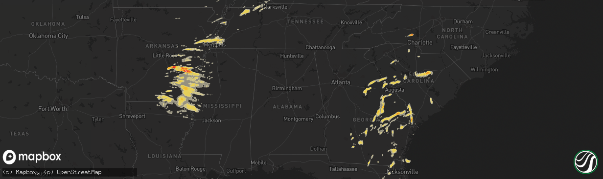
Hail Map on September 25, 2011
The weather event on September 25, 2011 includes Hail map. 15 states and 431 cities were impacted and suffered possible damage. The total estimated number of properties impacted is 0.
Want more than just the map?
Turn this storm into a full workflow.
- Owner + property data so you know who to knock
- OnDemand branded weather history reports to win the "did we even have hail?" argument
- RoofTrace estimate so reps stop guessing numbers at the door
Bought this map? Upgrade within 7 days and we'll credit the $230. (10-15 min setup call)
Hail
0
Estimated number of impacted properties by a 1.00" hail or larger0
Estimated number of impacted properties by a 1.75" hail or larger0
Estimated number of impacted properties by a 2.50" hail or largerStates Impacted by Hail Map on September 25, 2011
Storm reports
South Carolina
| Date | Description |
|---|---|
| 09/25/20116:45 PM CDT | Trees down between sumter and rembert...at catchall rd and sc 261...and furman field rd and us 521. |
| 09/25/20116:30 PM CDT | Trees down between sumter and rembert...at catchall rd and sc 261...and furman field rd and us 521. Time estimated based on radar. |
| 09/25/20116:00 PM CDT | Numerous reports of trees down throughout the city of columbia. |
| 09/25/20115:26 PM CDT | Public reported trees and live powerlines down off kilbourne rd. Near fort jackson blvd. |
| 09/25/20115:19 PM CDT | One tree down blocking portions of bells highway and doctors creek road. Time estimated by radar. |
| 09/25/20115:05 PM CDT | Numerous reports of trees down in the greater lexington and red bank vicinity |
| 09/25/20114:04 PM CDT | Trees down on old beach hill rd. Time estimated by radar. |
| 09/25/20113:35 PM CDT | One tree down near terry road. Time estimated by radar. |
| 09/25/20113:20 PM CDT | Numerous trees and power lines down on laurel ave...some trees fell on homes. No injuries. |
| 09/25/20112:57 PM CDT | Large limbs down on harper rd |
| 09/25/201112:40 PM CDT | Hail up to half dollar size reported in the city of laurens by spotter. |
| 09/25/201112:36 PM CDT | Spotter reported numerous trees down in the city of laurens. |
Florida
| Date | Description |
|---|---|
| 09/25/20113:20 PM CDT | Wind damage to trees was noted naer highway 41 at the echols and hamilton county line. |
Indiana
| Date | Description |
|---|---|
| 09/25/201112:33 AM CDT | A local report indicates 1.75 inch wind near 3 W NEW CASTLE |
| 09/24/201111:55 PM CDT | Tree downed in roadway near saint paul. |
| 09/24/201111:40 PM CDT | Two homes damaged... Pole barn destroyed. Trees and power poles downed. Tractors overturned. |
| 09/24/201111:33 PM CDT | Ef1 tornado with winds estimated near 100 mph. Occurred along county road 700 west between county roads 150 north and 300 north. Pole barn destroyed. Two homes damaged. |
Mississippi
| Date | Description |
|---|---|
| 09/24/201111:15 PM CDT | Trees and limbs reported down just west of the county line. Funnel cloud spotted in the vicinity at that time |
| 09/24/201110:10 PM CDT | Power lines down across hwy 12 near the washington/humphreys co line |
| 09/24/20119:05 PM CDT | A local report indicates 1.00 inch wind near SHAW |
| 09/24/20118:42 PM CDT | Trained spotter reporting tornado on the ground in benoit |
| 09/24/20118:40 PM CDT | Reliable spotter reports of tornado touching down briefly in benoit...along with favorable radar representation. However...storm survey crew could find no evidence of s |
| 09/24/20118:29 PM CDT | An agricultural pivot was flipped over...two trees were snapped...power lines were downed...the roofs were blown off a pumphouse and a baseball dugout...and playground |
| 09/24/20118:27 PM CDT | Heavy damage to the walmart and sears in the northern part of cleveland. Structures reported partially collapsed. |
| 09/24/20118:27 PM CDT | Substantial damage reported in the stanton subdivision |
| 09/24/20118:27 PM CDT | At least 2 dozen large...old...oak trees down on the campus of delta state university |
| 09/24/20118:25 PM CDT | Roof blown off of a pump house and power lines down at north sunflower academy located on academy road between drew and ruleville |
| 09/24/20118:20 PM CDT | 3 light poles snapped in half on mallette jones road approximately 100 yards south of highway 8. Possible tornado |
| 09/24/20118:20 PM CDT | Numerous trees on houses. |
| 09/24/20118:18 PM CDT | 60-70 mph estimated in cleveland. Power reported out. |
| 09/24/20118:15 PM CDT | Trained weather spotter reported tornado on the ground along township road just west of cleveland. |
| 09/24/20118:04 PM CDT | Heavily damaged four trailer homes and caused minor to moderate structural damage to many other buildings in and on the outskirts of cleveland. Hundreds of trees and ma |
| 09/24/20117:05 PM CDT | A local report indicates 1.00 inch wind near 3 N DEESON |
| 09/24/20117:00 PM CDT | Trees down on houses in gunnison |
Ohio
| Date | Description |
|---|---|
| 09/25/20116:55 PM CDT | A local report indicates 1.00 inch wind near BARNESVILLE |
| 09/25/20116:51 PM CDT | A local report indicates 1.00 inch wind near 3 S BARNESVILLE |
| 09/25/20116:30 PM CDT | Trees down on state route 78 |
| 09/25/20114:45 PM CDT | Old barn destroyed by wind |
| 09/25/20114:45 PM CDT | A local report indicates 1.00 inch wind near 3 W ORWELL |
| 09/25/20114:42 PM CDT | Trees and power lines down |
| 09/25/20114:42 PM CDT | Trees down |
| 09/25/20114:42 PM CDT | Trees down |
| 09/25/20114:40 PM CDT | Trees down |
| 09/24/20117:02 PM CDT | Large hail and heavy rain on state route 800 |
Arkansas
| Date | Description |
|---|---|
| 09/25/20116:34 PM CDT | 3.25 inch hail broke windows in a home and put large dents in vehicles. |
| 09/25/20116:34 PM CDT | A tree was blown down along hwy 44. |
| 09/25/20116:30 PM CDT | 2.25 inch hail was seen. |
| 09/25/20116:30 PM CDT | Tennis ball sized hail knocked skylights out of a business. |
| 09/25/20116:30 PM CDT | Golf ball to tennis ball sized hail put holes in siding. |
| 09/25/20116:26 PM CDT | In arkansas county an ef0 tornado was confirmed. Track started 2.8 miles west of tichnor and ended 1 mile wnw of tichnor for a total path length of 1.9 miles. This torn |
| 09/25/20116:16 PM CDT | A local report indicates 1.75 inch wind near 2 SSW ONE HORSE STORE |
| 09/25/20116:01 PM CDT | Nickel to quarter size hail falling at this time. |
| 09/25/20116:00 PM CDT | Hail ranged from quarters to ping pong sized. Heavy rainfall reported with almost two inches measured in one hour. |
| 09/25/20115:56 PM CDT | Quarter to ping pong sized hail was reported in de witt. |
| 09/25/20115:45 PM CDT | Hail broke the windshield of the spotters car. |
| 09/25/20115:03 PM CDT | Hail up to the size of baseballs was falling. |
| 09/25/20115:02 PM CDT | I40 truckstop at mm221 had an awning blown across the parking lot and a power pole snapped off. |
| 09/25/20114:57 PM CDT | A local report indicates 1.00 inch wind near 1 S HAZEN |
| 09/25/20114:53 PM CDT | Several trees were down in brinkley. |
| 09/25/20114:36 PM CDT | Hail ranging from the size of quarters to golf balls was falling in white hall and covering the ground. |
| 09/25/20114:27 PM CDT | At earle high school. |
| 09/25/20113:53 PM CDT | A local report indicates 1.00 inch wind near WYNNE |
| 09/24/201110:10 PM CDT | Large shed/chicken house heavily damaged along highway 133 south of crossett |
| 09/24/20119:47 PM CDT | A few trees were blown down |
| 09/24/20119:00 PM CDT | Trees and powerlines down in dermott |
| 09/24/20118:40 PM CDT | Two eighteen wheelers overturned...numerous treetops snapped off and a billboard blown over near the big bend truck stop on highway 65. Nws survey confirmed downburst |
| 09/24/20118:40 PM CDT | Two eighteen wheelers overturned...numerous treetops snapped off and a billboard blown over near the big bend truck stop on highway 65. Nws survey confirmed downburst |
| 09/24/20118:36 PM CDT | A local report indicates 1.00 inch wind near DERMOTT |
| 09/24/20117:15 PM CDT | A local report indicates 1.00 inch wind near 1 W DUMAS |
Tennessee
| Date | Description |
|---|---|
| 09/25/20116:26 PM CDT | Trees down along highway 70. |
| 09/25/20115:31 PM CDT | A local report indicates 1.00 inch wind near BOLTON |
| 09/25/20115:25 PM CDT | A local report indicates 1.75 inch wind near MILLINGTON |
| 09/25/20115:23 PM CDT | At millington elementary school and at millington police dept. |
| 09/25/20115:20 PM CDT | Also had 40-50 mph wind gusts. |
| 09/25/20115:18 PM CDT | A local report indicates 1.25 inch wind near 2 NW FRAYSER |
| 09/25/20113:50 PM CDT | Public reported penny to quarter size hail in dover |
Kentucky
| Date | Description |
|---|---|
| 09/25/20116:35 PM CDT | The dust collector on top of the marion feed mill was blown off leaving behind a large hole in the roof. Some downed trees resulted in power outages. |
| 09/25/201112:19 AM CDT | Trees down on bohannon lane...also on goshen lane. |
| 09/25/201112:04 AM CDT | Three trees uprooted |
| 09/24/20118:50 PM CDT | Nws storm survey reveals an ef1 tornado...90 mph winds...1 mile long path...100 yards in width. 2 barns damaged with several trees down/snapped. See pnspah for details. |
| 09/24/20118:25 PM CDT | Event occurred 3/4 mile s of community near intersection of hwy 813 and hardwick road. 1 framed home and 1 mobile home destroyed and two framed homes with minor damage. |
| 09/24/20118:25 PM CDT | 2 houses damaged in white plains and a trailer overturned near mortons gap. |
Georgia
| Date | Description |
|---|---|
| 09/25/20114:45 PM CDT | The 911 call center received 2 reports of trees down that were blocking canney bay and jess allen roads. The time given was based on radar. |
| 09/25/20113:35 PM CDT | Trees and power lines were damaged at the intersection of evelyn road and frank j. Culpepper road. |
| 09/25/20113:25 PM CDT | Mobile home trailer was turned over with roof damage also to storage and office buildings. |
| 09/25/20113:11 PM CDT | One tree down near highway 21 and eureka road. Time estimated by radar. |
| 09/25/20113:07 PM CDT | One tree down along union church road and windmill road. Time estimated by radar. |
| 09/25/20112:45 PM CDT | Several 3 inch diamater magnolia tree limbs down. Also received penny size hail. |
| 09/25/20112:34 PM CDT | Bulloch 911 center reports numerous large trees and power lines down. |
| 09/25/20112:29 PM CDT | Bulloch 911 center reports a large tree down on a house on lakeview road. The house sustained enough damage where the occupants are being sheltered by the red cross. |
| 09/25/20112:26 PM CDT | One large tree limb fell into lakeview baptist church. |
| 09/25/20112:26 PM CDT | Possible tornado. The tops sheared off large and very tall pine trees. Some people reported that the wind was blowing from one direction than abruptly changed and was b |
| 09/25/20112:25 PM CDT | Large tree down on lakeview baptist church. |
| 09/25/20112:25 PM CDT | Bulloch 911 center reports considerable hail damage across the northern part of the county. |
| 09/25/20112:19 PM CDT | A 50 feet tree fell and caused minor damage to a backyard deck. The tree created a large hole in the backyard where the expansive roots came out of the ground. |
| 09/25/20112:02 PM CDT | A local report indicates 1.75 inch wind near RINCON |
| 09/25/20111:50 PM CDT | 60 pecan trees downed at 4940 hwy 23 north. Time estimated by radar. |
| 09/25/20111:45 PM CDT | Numerous trees on power lines on cedar street. Time estimated by radar. |
| 09/25/20111:27 PM CDT | Time estimated by radar |
| 09/25/20111:27 PM CDT | Two large tree limbs down on a car. Estimates winds of 70 mph. |
North Carolina
| Date | Description |
|---|---|
| 09/25/20112:03 PM CDT | Trees down on salem church road and on main street. Pea size hail |
| 09/25/20112:00 PM CDT | A local report indicates 2.00 inch wind near LINCOLNTON |
Cities Impacted by Hail Map on September 25, 2011
- White Plains, GA
- Greensboro, GA
- Green Cove Springs, FL
- Rochelle, GA
- Fitzgerald, GA
- Rhine, GA
- Abbeville, GA
- Sardis, MS
- Crenshaw, MS
- Edgefield, SC
- Kingsland, GA
- Kings Bay, GA
- Saint Marys, GA
- Anguilla, MS
- Hollandale, MS
- White Hall, AR
- Altheimer, AR
- Sherrill, AR
- Hazlehurst, GA
- Monroe, LA
- Sterlington, LA
- Millington, TN
- Lincolnton, NC
- Oakfield, GA
- Warwick, GA
- Benoit, MS
- Dermott, AR
- Lake Village, AR
- Eatonton, GA
- Wilmar, AR
- Monticello, AR
- Sharon, SC
- York, SC
- Knightstown, IN
- Spiceland, IN
- Boyle, MS
- Cleveland, MS
- Shaw, MS
- Wrightsville, GA
- East Dublin, GA
- Adrian, GA
- Milan, GA
- McRae Helena, GA
- Finley, TN
- Bragg City, MO
- Dalzell, SC
- Sumter, SC
- Rembert, SC
- Nahunta, GA
- Pine Bluff, AR
- Clyo, GA
- Garnett, SC
- Avera, GA
- Stapleton, GA
- Louisville, GA
- Arkansas City, AR
- Portland, AR
- McGehee, AR
- Rentz, GA
- Dublin, GA
- Piedmont, OH
- Quaker City, OH
- Barnesville, OH
- Freeport, OH
- Hopkins, SC
- Columbia, SC
- Eastover, SC
- Estill, SC
- Luray, SC
- Coahoma, MS
- Cherryville, NC
- Lawndale, NC
- Dover, TN
- Arlington, TN
- Fort Lawn, SC
- Richburg, SC
- Lancaster, SC
- Hermitage, AR
- Springfield, GA
- Rincon, GA
- Williston, FL
- Batesburg, SC
- Leesville, SC
- Buchanan, TN
- New Concord, KY
- Doddsville, MS
- Earle, AR
- Dresden, TN
- Paris, TN
- Palmersville, TN
- Mayersville, MS
- Transylvania, LA
- Lake Providence, LA
- Oak Grove, LA
- Rolling Fork, MS
- Cary, MS
- De Witt, AR
- Almyra, AR
- Stuttgart, AR
- Indianola, MS
- Brinkley, AR
- Carlisle, AR
- Tifton, GA
- Alamo, GA
- New Castle, IN
- Sharon, TN
- Cottage Grove, TN
- Martin, TN
- Goodwin, AR
- Cotton Plant, AR
- Wheatley, AR
- Palestine, AR
- Joiner, AR
- Tyronza, AR
- Ridgeville, SC
- Holly Grove, AR
- Casscoe, AR
- Roe, AR
- Clarendon, AR
- Jones, LA
- Hamburg, AR
- Eudora, AR
- Wilmot, AR
- Bonita, LA
- Parkdale, AR
- El Dorado, AR
- Drew, MS
- Ruleville, MS
- Eads, TN
- Hazen, AR
- Herndon, KY
- Bartow, GA
- Wadley, GA
- Kite, GA
- Sylvania, GA
- Lewisville, OH
- Poplar Bluff, MO
- Wabbaseka, AR
- Soperton, GA
- Tarrytown, GA
- Vidalia, GA
- Old Town, FL
- Baxley, GA
- Fargo, GA
- De Valls Bluff, AR
- Hardeeville, SC
- Blythe, GA
- Hephzibah, GA
- Laurens, SC
- Greenville, MS
- Beulah, MS
- Rohwer, AR
- Clinton, SC
- Tichnor, AR
- Gillett, AR
- Glennville, GA
- Odum, GA
- Memphis, TN
- De Leon Springs, FL
- Pierson, FL
- Drummonds, TN
- Enigma, GA
- Saint Charles, AR
- Elaine, AR
- Ethel, AR
- Crossett, AR
- Fernandina Beach, FL
- Fort Stewart, GA
- Pembroke, GA
- Waycross, GA
- Thomson, GA
- Appling, GA
- Lincolnton, GA
- Hopkinsville, KY
- Statesboro, GA
- Portal, GA
- Wrens, GA
- Archer, FL
- North Augusta, SC
- Clarks Hill, SC
- Trenton, SC
- Johnston, SC
- Bloomingdale, GA
- Guyton, GA
- Saint Marys, WV
- Davisboro, GA
- Twin City, GA
- Swainsboro, GA
- Lyons, GA
- Metter, GA
- Marion, LA
- Rayle, GA
- Union Point, GA
- Humphrey, AR
- McConnells, SC
- Dumas, AR
- Grady, AR
- Star City, AR
- Turrell, AR
- Shelby, MS
- Duncan, MS
- Gunnison, MS
- Snow Lake, AR
- Huttig, AR
- Strong, AR
- Lake Park, GA
- Marion, AR
- Wynne, AR
- Crawfordsville, AR
- Parkin, AR
- Mount Vernon, GA
- Uvalda, GA
- Ailey, GA
- Fairdale, KY
- Brooks, KY
- Shepherdsville, KY
- Louisville, KY
- Puryear, TN
- Reidsville, GA
- Wappapello, MO
- McGee, MO
- Jersey, AR
- Tignall, GA
- Washington, GA
- McCormick, SC
- Sylvester, GA
- Hughes, AR
- Forrest City, AR
- Collins, GA
- Gilbert, SC
- Waynesboro, GA
- Parchman, MS
- Tutwiler, MS
- Saluda, SC
- Newington, GA
- Cobbtown, GA
- Lugoff, SC
- Sledge, MS
- Dundee, MS
- Yazoo City, MS
- Evening Shade, AR
- Big Rock, TN
- Bumpus Mills, TN
- Orwell, OH
- Middlefield, OH
- Windsor, OH
- Richland, IN
- Warren, AR
- Leland, MS
- Rockledge, GA
- Modoc, SC
- Grandin, MO
- Ellsinore, MO
- Williamsville, MO
- Chauncey, GA
- Jennings, FL
- Bronson, FL
- Summerville, SC
- Farmerville, LA
- Troy, SC
- Stewart, TN
- Big Sandy, TN
- Morriston, FL
- Keysville, GA
- Pickens, AR
- Tillar, AR
- Winchester, AR
- Rayville, LA
- Oak Ridge, LA
- Rison, AR
- Chatham, MS
- Glen Allan, MS
- Carthage, IN
- Marianna, AR
- Des Arc, AR
- Saint George, GA
- Register, GA
- Port Wentworth, GA
- Augusta, AR
- Boonville, IN
- Tennyson, IN
- Rosedale, MS
- Watson, AR
- Mound Bayou, MS
- Branford, FL
- Pioneer, LA
- Epps, LA
- Hoboken, GA
- Folkston, GA
- Woodlawn, TN
- Indian Mound, TN
- Chrisney, IN
- Paducah, KY
- High Springs, FL
- Alachua, FL
- Savannah, GA
- Tillman, SC
- Fairfax, SC
- Pineland, SC
- Lonoke, AR
- Scott, AR
- Blytheville, AR
- Patterson, GA
- Minter City, MS
- Lake Butler, FL
- Matthews, GA
- Dorchester, SC
- Sanderson, FL
- Schlater, MS
- Caruthersville, MO
- Hornersville, MO
- Steele, MO
- Cruger, MS
- Valley Park, MS
- Lambert, MS
- Neelyville, MO
- Burton, OH
- Hilliard, FL
- Clarksdale, MS
- Lamar, IN
- Symsonia, KY
- Benton, KY
- Spencer, WV
- Elizabeth, WV
- Reedy, WV
- Palestine, WV
- Creston, WV
- Montrose, AR
- Bastrop, LA
- Inverness, MS
- Isola, MS
- Mer Rouge, LA
- Ripley, TN
- Hazel, KY
- Gibson, GA
- Lexa, AR
- Ashburn, GA
- Atoka, TN
- Macclenny, FL
- Glen Saint Mary, FL
- Hortense, GA
- Screven, GA
- Doerun, GA
- Moultrie, GA
- Leachville, AR
- Merigold, MS
- Woodsfield, OH
- Grandview, IN
- Patton, MO
- Sedgewickville, MO
- Charleston, MS
- Maiden, NC
- Crouse, NC
- Denver, NC
- Iron Station, NC
- Cecilia, KY
- Sandersville, GA
- Tallulah, LA
- Griffithville, AR
- Greenfield, TN
- Cadwell, GA
- Van Buren, MO
- Henderson, KY
- Fountain Hill, AR
- Aiken, SC
- Ridge Spring, SC
- Shaw Afb, SC
- Mayesville, SC
- Bishopville, SC
- Camden, SC
- Wedgefield, SC
- Blythewood, SC
- Rebecca, GA
- Aubrey, AR
- Sumner, GA
- Du Pont, GA
- Stockton, GA
- Bells, TN
- Cordova, TN
- Colt, AR
- Mason, TN
- Munford, TN
- England, AR
- Gleason, TN
- Santa Claus, IN
- Dexter, MO
- Bernice, LA
- Verona, WI
- Delhi, LA
- West Monroe, LA
- Ellabell, GA
- Ferdinand, IN
- Graysville, OH
- Newport, OH
- New Matamoras, OH
- Dukedom, TN
- Fulton, KY
- Rockport, IN
- Murray, KY
- Horseshoe Bend, AR
- Big Clifty, KY
- Alligator, MS
- Poulan, GA
- Hampton, AR
- Melbourne, AR
- Marquand, MO
- Greenwood, MS
- Belzoni, MS
- Sunflower, MS
- Gould, AR
- Spearsville, LA
- Seymour, IN
- Cherry Valley, AR
- Cadiz, KY
- Lyons, MI
- Itta Bena, MS
- Trenton, FL
- Newberry, FL
- Fort White, FL
- Lumber City, GA
- Glenwood, GA
- Sparta, GA
- Franklin, AR
- Lake City, FL
- Sage, AR
- West Helena, AR
- Vine Grove, KY
- Radcliff, KY
- West Point, KY
- Fort Knox, KY
- Rineyville, KY