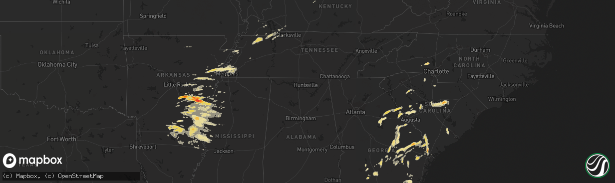
Hail Map in Kentucky on September 25, 2011
The weather event in Kentucky on September 25, 2011 includes Hail map. 15 states and 431 cities were impacted and suffered possible damage. The total estimated number of properties impacted is 0.
Want more than just the map?
Turn this storm into a full workflow.
- Owner + property data so you know who to knock
- OnDemand branded weather history reports to win the "did we even have hail?" argument
- RoofTrace estimate so reps stop guessing numbers at the door
Bought this map? Upgrade within 7 days and we'll credit the $230. (10-15 min setup call)
Hail
0
Estimated number of impacted properties by a 1.00" hail or larger0
Estimated number of impacted properties by a 1.75" hail or larger0
Estimated number of impacted properties by a 2.50" hail or largerStorm reports in Kentucky
Kentucky
| Date | Description |
|---|---|
| 09/25/20116:35 PM CDT | The dust collector on top of the marion feed mill was blown off leaving behind a large hole in the roof. Some downed trees resulted in power outages. |
| 09/25/201112:19 AM CDT | Trees down on bohannon lane...also on goshen lane. |
| 09/25/201112:04 AM CDT | Three trees uprooted |
| 09/24/20118:50 PM CDT | Nws storm survey reveals an ef1 tornado...90 mph winds...1 mile long path...100 yards in width. 2 barns damaged with several trees down/snapped. See pnspah for details. |
| 09/24/20118:25 PM CDT | Event occurred 3/4 mile s of community near intersection of hwy 813 and hardwick road. 1 framed home and 1 mobile home destroyed and two framed homes with minor damage. |
| 09/24/20118:25 PM CDT | 2 houses damaged in white plains and a trailer overturned near mortons gap. |
All States Impacted by Hail Map on September 25, 2011
Cities Impacted by Hail Map on September 25, 2011
- White Plains, GA
- Greensboro, GA
- Green Cove Springs, FL
- Rochelle, GA
- Fitzgerald, GA
- Rhine, GA
- Abbeville, GA
- Sardis, MS
- Crenshaw, MS
- Edgefield, SC
- Kingsland, GA
- Kings Bay, GA
- Saint Marys, GA
- Anguilla, MS
- Hollandale, MS
- White Hall, AR
- Altheimer, AR
- Sherrill, AR
- Hazlehurst, GA
- Monroe, LA
- Sterlington, LA
- Millington, TN
- Lincolnton, NC
- Oakfield, GA
- Warwick, GA
- Benoit, MS
- Dermott, AR
- Lake Village, AR
- Eatonton, GA
- Wilmar, AR
- Monticello, AR
- Sharon, SC
- York, SC
- Knightstown, IN
- Spiceland, IN
- Boyle, MS
- Cleveland, MS
- Shaw, MS
- Wrightsville, GA
- East Dublin, GA
- Adrian, GA
- Milan, GA
- McRae Helena, GA
- Finley, TN
- Bragg City, MO
- Dalzell, SC
- Sumter, SC
- Rembert, SC
- Nahunta, GA
- Pine Bluff, AR
- Clyo, GA
- Garnett, SC
- Avera, GA
- Stapleton, GA
- Louisville, GA
- Arkansas City, AR
- Portland, AR
- McGehee, AR
- Rentz, GA
- Dublin, GA
- Piedmont, OH
- Quaker City, OH
- Barnesville, OH
- Freeport, OH
- Hopkins, SC
- Columbia, SC
- Eastover, SC
- Estill, SC
- Luray, SC
- Coahoma, MS
- Cherryville, NC
- Lawndale, NC
- Dover, TN
- Arlington, TN
- Fort Lawn, SC
- Richburg, SC
- Lancaster, SC
- Hermitage, AR
- Springfield, GA
- Rincon, GA
- Williston, FL
- Batesburg, SC
- Leesville, SC
- Buchanan, TN
- New Concord, KY
- Doddsville, MS
- Earle, AR
- Dresden, TN
- Paris, TN
- Palmersville, TN
- Mayersville, MS
- Transylvania, LA
- Lake Providence, LA
- Oak Grove, LA
- Rolling Fork, MS
- Cary, MS
- De Witt, AR
- Almyra, AR
- Stuttgart, AR
- Indianola, MS
- Brinkley, AR
- Carlisle, AR
- Tifton, GA
- Alamo, GA
- New Castle, IN
- Sharon, TN
- Cottage Grove, TN
- Martin, TN
- Goodwin, AR
- Cotton Plant, AR
- Wheatley, AR
- Palestine, AR
- Joiner, AR
- Tyronza, AR
- Ridgeville, SC
- Holly Grove, AR
- Casscoe, AR
- Roe, AR
- Clarendon, AR
- Jones, LA
- Hamburg, AR
- Eudora, AR
- Wilmot, AR
- Bonita, LA
- Parkdale, AR
- El Dorado, AR
- Drew, MS
- Ruleville, MS
- Eads, TN
- Hazen, AR
- Herndon, KY
- Bartow, GA
- Wadley, GA
- Kite, GA
- Sylvania, GA
- Lewisville, OH
- Poplar Bluff, MO
- Wabbaseka, AR
- Soperton, GA
- Tarrytown, GA
- Vidalia, GA
- Old Town, FL
- Baxley, GA
- Fargo, GA
- De Valls Bluff, AR
- Hardeeville, SC
- Blythe, GA
- Hephzibah, GA
- Laurens, SC
- Greenville, MS
- Beulah, MS
- Rohwer, AR
- Clinton, SC
- Tichnor, AR
- Gillett, AR
- Glennville, GA
- Odum, GA
- Memphis, TN
- De Leon Springs, FL
- Pierson, FL
- Drummonds, TN
- Enigma, GA
- Saint Charles, AR
- Elaine, AR
- Ethel, AR
- Crossett, AR
- Fernandina Beach, FL
- Fort Stewart, GA
- Pembroke, GA
- Waycross, GA
- Thomson, GA
- Appling, GA
- Lincolnton, GA
- Hopkinsville, KY
- Statesboro, GA
- Portal, GA
- Wrens, GA
- Archer, FL
- North Augusta, SC
- Clarks Hill, SC
- Trenton, SC
- Johnston, SC
- Bloomingdale, GA
- Guyton, GA
- Saint Marys, WV
- Davisboro, GA
- Twin City, GA
- Swainsboro, GA
- Lyons, GA
- Metter, GA
- Marion, LA
- Rayle, GA
- Union Point, GA
- Humphrey, AR
- McConnells, SC
- Dumas, AR
- Grady, AR
- Star City, AR
- Turrell, AR
- Shelby, MS
- Duncan, MS
- Gunnison, MS
- Snow Lake, AR
- Huttig, AR
- Strong, AR
- Lake Park, GA
- Marion, AR
- Wynne, AR
- Crawfordsville, AR
- Parkin, AR
- Mount Vernon, GA
- Uvalda, GA
- Ailey, GA
- Fairdale, KY
- Brooks, KY
- Shepherdsville, KY
- Louisville, KY
- Puryear, TN
- Reidsville, GA
- Wappapello, MO
- McGee, MO
- Jersey, AR
- Tignall, GA
- Washington, GA
- McCormick, SC
- Sylvester, GA
- Hughes, AR
- Forrest City, AR
- Collins, GA
- Gilbert, SC
- Waynesboro, GA
- Parchman, MS
- Tutwiler, MS
- Saluda, SC
- Newington, GA
- Cobbtown, GA
- Lugoff, SC
- Sledge, MS
- Dundee, MS
- Yazoo City, MS
- Evening Shade, AR
- Big Rock, TN
- Bumpus Mills, TN
- Orwell, OH
- Middlefield, OH
- Windsor, OH
- Richland, IN
- Warren, AR
- Leland, MS
- Rockledge, GA
- Modoc, SC
- Grandin, MO
- Ellsinore, MO
- Williamsville, MO
- Chauncey, GA
- Jennings, FL
- Bronson, FL
- Summerville, SC
- Farmerville, LA
- Troy, SC
- Stewart, TN
- Big Sandy, TN
- Morriston, FL
- Keysville, GA
- Pickens, AR
- Tillar, AR
- Winchester, AR
- Rayville, LA
- Oak Ridge, LA
- Rison, AR
- Chatham, MS
- Glen Allan, MS
- Carthage, IN
- Marianna, AR
- Des Arc, AR
- Saint George, GA
- Register, GA
- Port Wentworth, GA
- Augusta, AR
- Boonville, IN
- Tennyson, IN
- Rosedale, MS
- Watson, AR
- Mound Bayou, MS
- Branford, FL
- Pioneer, LA
- Epps, LA
- Hoboken, GA
- Folkston, GA
- Woodlawn, TN
- Indian Mound, TN
- Chrisney, IN
- Paducah, KY
- High Springs, FL
- Alachua, FL
- Savannah, GA
- Tillman, SC
- Fairfax, SC
- Pineland, SC
- Lonoke, AR
- Scott, AR
- Blytheville, AR
- Patterson, GA
- Minter City, MS
- Lake Butler, FL
- Matthews, GA
- Dorchester, SC
- Sanderson, FL
- Schlater, MS
- Caruthersville, MO
- Hornersville, MO
- Steele, MO
- Cruger, MS
- Valley Park, MS
- Lambert, MS
- Neelyville, MO
- Burton, OH
- Hilliard, FL
- Clarksdale, MS
- Lamar, IN
- Symsonia, KY
- Benton, KY
- Spencer, WV
- Elizabeth, WV
- Reedy, WV
- Palestine, WV
- Creston, WV
- Montrose, AR
- Bastrop, LA
- Inverness, MS
- Isola, MS
- Mer Rouge, LA
- Ripley, TN
- Hazel, KY
- Gibson, GA
- Lexa, AR
- Ashburn, GA
- Atoka, TN
- Macclenny, FL
- Glen Saint Mary, FL
- Hortense, GA
- Screven, GA
- Doerun, GA
- Moultrie, GA
- Leachville, AR
- Merigold, MS
- Woodsfield, OH
- Grandview, IN
- Patton, MO
- Sedgewickville, MO
- Charleston, MS
- Maiden, NC
- Crouse, NC
- Denver, NC
- Iron Station, NC
- Cecilia, KY
- Sandersville, GA
- Tallulah, LA
- Griffithville, AR
- Greenfield, TN
- Cadwell, GA
- Van Buren, MO
- Henderson, KY
- Fountain Hill, AR
- Aiken, SC
- Ridge Spring, SC
- Shaw Afb, SC
- Mayesville, SC
- Bishopville, SC
- Camden, SC
- Wedgefield, SC
- Blythewood, SC
- Rebecca, GA
- Aubrey, AR
- Sumner, GA
- Du Pont, GA
- Stockton, GA
- Bells, TN
- Cordova, TN
- Colt, AR
- Mason, TN
- Munford, TN
- England, AR
- Gleason, TN
- Santa Claus, IN
- Dexter, MO
- Bernice, LA
- Verona, WI
- Delhi, LA
- West Monroe, LA
- Ellabell, GA
- Ferdinand, IN
- Graysville, OH
- Newport, OH
- New Matamoras, OH
- Dukedom, TN
- Fulton, KY
- Rockport, IN
- Murray, KY
- Horseshoe Bend, AR
- Big Clifty, KY
- Alligator, MS
- Poulan, GA
- Hampton, AR
- Melbourne, AR
- Marquand, MO
- Greenwood, MS
- Belzoni, MS
- Sunflower, MS
- Gould, AR
- Spearsville, LA
- Seymour, IN
- Cherry Valley, AR
- Cadiz, KY
- Lyons, MI
- Itta Bena, MS
- Trenton, FL
- Newberry, FL
- Fort White, FL
- Lumber City, GA
- Glenwood, GA
- Sparta, GA
- Franklin, AR
- Lake City, FL
- Sage, AR
- West Helena, AR
- Vine Grove, KY
- Radcliff, KY
- West Point, KY
- Fort Knox, KY
- Rineyville, KY


