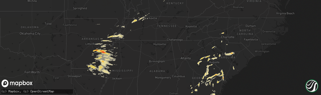
Hail Map in South Carolina on September 25, 2011
The weather event in South Carolina on September 25, 2011 includes Hail map. 15 states and 431 cities were impacted and suffered possible damage. The total estimated number of properties impacted is 0.
Want more than just the map?
Turn this storm into a full workflow.
- Owner + property data so you know who to knock
- OnDemand branded weather history reports to win the "did we even have hail?" argument
- RoofTrace estimate so reps stop guessing numbers at the door
Bought this map? Upgrade within 7 days and we'll credit the $230. (10-15 min setup call)
Hail
0
Estimated number of impacted properties by a 1.00" hail or larger0
Estimated number of impacted properties by a 1.75" hail or larger0
Estimated number of impacted properties by a 2.50" hail or largerStorm reports in South Carolina
South Carolina
| Date | Description |
|---|---|
| 09/25/20116:45 PM CDT | Trees down between sumter and rembert...at catchall rd and sc 261...and furman field rd and us 521. |
| 09/25/20116:30 PM CDT | Trees down between sumter and rembert...at catchall rd and sc 261...and furman field rd and us 521. Time estimated based on radar. |
| 09/25/20116:00 PM CDT | Numerous reports of trees down throughout the city of columbia. |
| 09/25/20115:26 PM CDT | Public reported trees and live powerlines down off kilbourne rd. Near fort jackson blvd. |
| 09/25/20115:19 PM CDT | One tree down blocking portions of bells highway and doctors creek road. Time estimated by radar. |
| 09/25/20115:05 PM CDT | Numerous reports of trees down in the greater lexington and red bank vicinity |
| 09/25/20114:04 PM CDT | Trees down on old beach hill rd. Time estimated by radar. |
| 09/25/20113:35 PM CDT | One tree down near terry road. Time estimated by radar. |
| 09/25/20113:20 PM CDT | Numerous trees and power lines down on laurel ave...some trees fell on homes. No injuries. |
| 09/25/20112:57 PM CDT | Large limbs down on harper rd |
| 09/25/201112:40 PM CDT | Hail up to half dollar size reported in the city of laurens by spotter. |
| 09/25/201112:36 PM CDT | Spotter reported numerous trees down in the city of laurens. |
All States Impacted by Hail Map on September 25, 2011
Cities Impacted by Hail Map on September 25, 2011
- White Plains, GA
- Greensboro, GA
- Green Cove Springs, FL
- Rochelle, GA
- Fitzgerald, GA
- Rhine, GA
- Abbeville, GA
- Sardis, MS
- Crenshaw, MS
- Edgefield, SC
- Kingsland, GA
- Kings Bay, GA
- Saint Marys, GA
- Anguilla, MS
- Hollandale, MS
- White Hall, AR
- Altheimer, AR
- Sherrill, AR
- Hazlehurst, GA
- Monroe, LA
- Sterlington, LA
- Millington, TN
- Lincolnton, NC
- Oakfield, GA
- Warwick, GA
- Benoit, MS
- Dermott, AR
- Lake Village, AR
- Eatonton, GA
- Wilmar, AR
- Monticello, AR
- Sharon, SC
- York, SC
- Knightstown, IN
- Spiceland, IN
- Boyle, MS
- Cleveland, MS
- Shaw, MS
- Wrightsville, GA
- East Dublin, GA
- Adrian, GA
- Milan, GA
- McRae Helena, GA
- Finley, TN
- Bragg City, MO
- Dalzell, SC
- Sumter, SC
- Rembert, SC
- Nahunta, GA
- Pine Bluff, AR
- Clyo, GA
- Garnett, SC
- Avera, GA
- Stapleton, GA
- Louisville, GA
- Arkansas City, AR
- Portland, AR
- McGehee, AR
- Rentz, GA
- Dublin, GA
- Piedmont, OH
- Quaker City, OH
- Barnesville, OH
- Freeport, OH
- Hopkins, SC
- Columbia, SC
- Eastover, SC
- Estill, SC
- Luray, SC
- Coahoma, MS
- Cherryville, NC
- Lawndale, NC
- Dover, TN
- Arlington, TN
- Fort Lawn, SC
- Richburg, SC
- Lancaster, SC
- Hermitage, AR
- Springfield, GA
- Rincon, GA
- Williston, FL
- Batesburg, SC
- Leesville, SC
- Buchanan, TN
- New Concord, KY
- Doddsville, MS
- Earle, AR
- Dresden, TN
- Paris, TN
- Palmersville, TN
- Mayersville, MS
- Transylvania, LA
- Lake Providence, LA
- Oak Grove, LA
- Rolling Fork, MS
- Cary, MS
- De Witt, AR
- Almyra, AR
- Stuttgart, AR
- Indianola, MS
- Brinkley, AR
- Carlisle, AR
- Tifton, GA
- Alamo, GA
- New Castle, IN
- Sharon, TN
- Cottage Grove, TN
- Martin, TN
- Goodwin, AR
- Cotton Plant, AR
- Wheatley, AR
- Palestine, AR
- Joiner, AR
- Tyronza, AR
- Ridgeville, SC
- Holly Grove, AR
- Casscoe, AR
- Roe, AR
- Clarendon, AR
- Jones, LA
- Hamburg, AR
- Eudora, AR
- Wilmot, AR
- Bonita, LA
- Parkdale, AR
- El Dorado, AR
- Drew, MS
- Ruleville, MS
- Eads, TN
- Hazen, AR
- Herndon, KY
- Bartow, GA
- Wadley, GA
- Kite, GA
- Sylvania, GA
- Lewisville, OH
- Poplar Bluff, MO
- Wabbaseka, AR
- Soperton, GA
- Tarrytown, GA
- Vidalia, GA
- Old Town, FL
- Baxley, GA
- Fargo, GA
- De Valls Bluff, AR
- Hardeeville, SC
- Blythe, GA
- Hephzibah, GA
- Laurens, SC
- Greenville, MS
- Beulah, MS
- Rohwer, AR
- Clinton, SC
- Tichnor, AR
- Gillett, AR
- Glennville, GA
- Odum, GA
- Memphis, TN
- De Leon Springs, FL
- Pierson, FL
- Drummonds, TN
- Enigma, GA
- Saint Charles, AR
- Elaine, AR
- Ethel, AR
- Crossett, AR
- Fernandina Beach, FL
- Fort Stewart, GA
- Pembroke, GA
- Waycross, GA
- Thomson, GA
- Appling, GA
- Lincolnton, GA
- Hopkinsville, KY
- Statesboro, GA
- Portal, GA
- Wrens, GA
- Archer, FL
- North Augusta, SC
- Clarks Hill, SC
- Trenton, SC
- Johnston, SC
- Bloomingdale, GA
- Guyton, GA
- Saint Marys, WV
- Davisboro, GA
- Twin City, GA
- Swainsboro, GA
- Lyons, GA
- Metter, GA
- Marion, LA
- Rayle, GA
- Union Point, GA
- Humphrey, AR
- McConnells, SC
- Dumas, AR
- Grady, AR
- Star City, AR
- Turrell, AR
- Shelby, MS
- Duncan, MS
- Gunnison, MS
- Snow Lake, AR
- Huttig, AR
- Strong, AR
- Lake Park, GA
- Marion, AR
- Wynne, AR
- Crawfordsville, AR
- Parkin, AR
- Mount Vernon, GA
- Uvalda, GA
- Ailey, GA
- Fairdale, KY
- Brooks, KY
- Shepherdsville, KY
- Louisville, KY
- Puryear, TN
- Reidsville, GA
- Wappapello, MO
- McGee, MO
- Jersey, AR
- Tignall, GA
- Washington, GA
- McCormick, SC
- Sylvester, GA
- Hughes, AR
- Forrest City, AR
- Collins, GA
- Gilbert, SC
- Waynesboro, GA
- Parchman, MS
- Tutwiler, MS
- Saluda, SC
- Newington, GA
- Cobbtown, GA
- Lugoff, SC
- Sledge, MS
- Dundee, MS
- Yazoo City, MS
- Evening Shade, AR
- Big Rock, TN
- Bumpus Mills, TN
- Orwell, OH
- Middlefield, OH
- Windsor, OH
- Richland, IN
- Warren, AR
- Leland, MS
- Rockledge, GA
- Modoc, SC
- Grandin, MO
- Ellsinore, MO
- Williamsville, MO
- Chauncey, GA
- Jennings, FL
- Bronson, FL
- Summerville, SC
- Farmerville, LA
- Troy, SC
- Stewart, TN
- Big Sandy, TN
- Morriston, FL
- Keysville, GA
- Pickens, AR
- Tillar, AR
- Winchester, AR
- Rayville, LA
- Oak Ridge, LA
- Rison, AR
- Chatham, MS
- Glen Allan, MS
- Carthage, IN
- Marianna, AR
- Des Arc, AR
- Saint George, GA
- Register, GA
- Port Wentworth, GA
- Augusta, AR
- Boonville, IN
- Tennyson, IN
- Rosedale, MS
- Watson, AR
- Mound Bayou, MS
- Branford, FL
- Pioneer, LA
- Epps, LA
- Hoboken, GA
- Folkston, GA
- Woodlawn, TN
- Indian Mound, TN
- Chrisney, IN
- Paducah, KY
- High Springs, FL
- Alachua, FL
- Savannah, GA
- Tillman, SC
- Fairfax, SC
- Pineland, SC
- Lonoke, AR
- Scott, AR
- Blytheville, AR
- Patterson, GA
- Minter City, MS
- Lake Butler, FL
- Matthews, GA
- Dorchester, SC
- Sanderson, FL
- Schlater, MS
- Caruthersville, MO
- Hornersville, MO
- Steele, MO
- Cruger, MS
- Valley Park, MS
- Lambert, MS
- Neelyville, MO
- Burton, OH
- Hilliard, FL
- Clarksdale, MS
- Lamar, IN
- Symsonia, KY
- Benton, KY
- Spencer, WV
- Elizabeth, WV
- Reedy, WV
- Palestine, WV
- Creston, WV
- Montrose, AR
- Bastrop, LA
- Inverness, MS
- Isola, MS
- Mer Rouge, LA
- Ripley, TN
- Hazel, KY
- Gibson, GA
- Lexa, AR
- Ashburn, GA
- Atoka, TN
- Macclenny, FL
- Glen Saint Mary, FL
- Hortense, GA
- Screven, GA
- Doerun, GA
- Moultrie, GA
- Leachville, AR
- Merigold, MS
- Woodsfield, OH
- Grandview, IN
- Patton, MO
- Sedgewickville, MO
- Charleston, MS
- Maiden, NC
- Crouse, NC
- Denver, NC
- Iron Station, NC
- Cecilia, KY
- Sandersville, GA
- Tallulah, LA
- Griffithville, AR
- Greenfield, TN
- Cadwell, GA
- Van Buren, MO
- Henderson, KY
- Fountain Hill, AR
- Aiken, SC
- Ridge Spring, SC
- Shaw Afb, SC
- Mayesville, SC
- Bishopville, SC
- Camden, SC
- Wedgefield, SC
- Blythewood, SC
- Rebecca, GA
- Aubrey, AR
- Sumner, GA
- Du Pont, GA
- Stockton, GA
- Bells, TN
- Cordova, TN
- Colt, AR
- Mason, TN
- Munford, TN
- England, AR
- Gleason, TN
- Santa Claus, IN
- Dexter, MO
- Bernice, LA
- Verona, WI
- Delhi, LA
- West Monroe, LA
- Ellabell, GA
- Ferdinand, IN
- Graysville, OH
- Newport, OH
- New Matamoras, OH
- Dukedom, TN
- Fulton, KY
- Rockport, IN
- Murray, KY
- Horseshoe Bend, AR
- Big Clifty, KY
- Alligator, MS
- Poulan, GA
- Hampton, AR
- Melbourne, AR
- Marquand, MO
- Greenwood, MS
- Belzoni, MS
- Sunflower, MS
- Gould, AR
- Spearsville, LA
- Seymour, IN
- Cherry Valley, AR
- Cadiz, KY
- Lyons, MI
- Itta Bena, MS
- Trenton, FL
- Newberry, FL
- Fort White, FL
- Lumber City, GA
- Glenwood, GA
- Sparta, GA
- Franklin, AR
- Lake City, FL
- Sage, AR
- West Helena, AR
- Vine Grove, KY
- Radcliff, KY
- West Point, KY
- Fort Knox, KY
- Rineyville, KY


