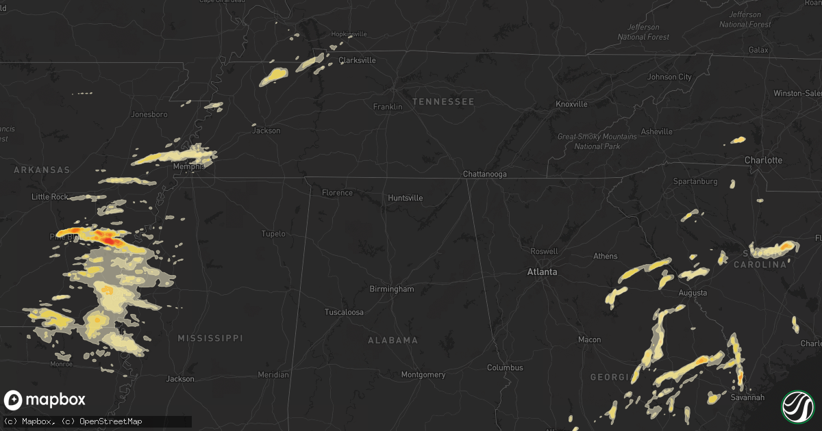
Hail Map in Arkansas on September 25, 2011
Get this storm
September 25 map
$229
one time, instant access
Download today. No call, no setup
Keep the $229
Bought the map and want the full workflow? Apply the entire $229 to a subscription within 7 days. None of it is wasted.
Every map, not just this one
This buys you this map. Subscription and you get every map we run, in the markets you choose from a few cities to whole states to nationwide. Plus real-time alerts the moment a storm fires.
Contact data
Name, contact info, occupancy, even credit band for addresses in the footprint. You go from where it hit to who to call.
Become the source they trust
Unlimited branding weather history reports on demand. You already have the documented answer ready for the property owner, and you are the one who showed up with it.
Property data and RoofTrace estimates
Pull up any address you have got, its value and the exact code rules for that jurisdiction, straight from One Click Code. Then RoofTrace estimates the squares, pitch, and roof value, priced the way you price.
Storm reports in Arkansas
Arkansas
| Date | Description |
|---|---|
| 09/25/20116:34 PM CDT | 3.25 inch hail broke windows in a home and put large dents in vehicles. |
| 09/25/20116:34 PM CDT | A tree was blown down along hwy 44. |
| 09/25/20116:30 PM CDT | 2.25 inch hail was seen. |
| 09/25/20116:30 PM CDT | Golf ball to tennis ball sized hail put holes in siding. |
| 09/25/20116:30 PM CDT | Tennis ball sized hail knocked skylights out of a business. |
| 09/25/20116:26 PM CDT | In arkansas county an ef0 tornado was confirmed. Track started 2.8 miles west of tichnor and ended 1 mile wnw of tichnor for a total path length of 1.9 miles. This torn |
| 09/25/20116:16 PM CDT | A local report indicates 1.75 inch wind near 2 SSW ONE HORSE STORE |
| 09/25/20116:01 PM CDT | Nickel to quarter size hail falling at this time. |
| 09/25/20116:00 PM CDT | Hail ranged from quarters to ping pong sized. Heavy rainfall reported with almost two inches measured in one hour. |
| 09/25/20115:56 PM CDT | Quarter to ping pong sized hail was reported in de witt. |
| 09/25/20115:45 PM CDT | Hail broke the windshield of the spotters car. |
| 09/25/20115:03 PM CDT | Hail up to the size of baseballs was falling. |
| 09/25/20115:02 PM CDT | I40 truckstop at mm221 had an awning blown across the parking lot and a power pole snapped off. |
| 09/25/20114:57 PM CDT | A local report indicates 1.00 inch wind near 1 S HAZEN |
| 09/25/20114:53 PM CDT | Several trees were down in brinkley. |
| 09/25/20114:36 PM CDT | Hail ranging from the size of quarters to golf balls was falling in white hall and covering the ground. |
| 09/25/20114:27 PM CDT | At earle high school. |
| 09/25/20113:53 PM CDT | A local report indicates 1.00 inch wind near WYNNE |
| 09/24/201110:10 PM CDT | Large shed/chicken house heavily damaged along highway 133 south of crossett |
| 09/24/20119:47 PM CDT | A few trees were blown down |
| 09/24/20119:00 PM CDT | Trees and powerlines down in dermott |
| 09/24/20118:40 PM CDT | Two eighteen wheelers overturned...numerous treetops snapped off and a billboard blown over near the big bend truck stop on highway 65. Nws survey confirmed downburst |
| 09/24/20118:40 PM CDT | Two eighteen wheelers overturned...numerous treetops snapped off and a billboard blown over near the big bend truck stop on highway 65. Nws survey confirmed downburst |
| 09/24/20118:36 PM CDT | A local report indicates 1.00 inch wind near DERMOTT |
| 09/24/20117:15 PM CDT | A local report indicates 1.00 inch wind near 1 W DUMAS |
All States Impacted by Hail Map on September 25, 2011
Cities Impacted by Hail Map on September 25, 2011
- White Plains, GA
- Greensboro, GA
- Green Cove Springs, FL
- Rochelle, GA
- Fitzgerald, GA
- Rhine, GA
- Abbeville, GA
- Sardis, MS
- Crenshaw, MS
- Edgefield, SC
- Kingsland, GA
- Kings Bay, GA
- Saint Marys, GA
- Anguilla, MS
- Hollandale, MS
- White Hall, AR
- Altheimer, AR
- Sherrill, AR
- Hazlehurst, GA
- Monroe, LA
- Sterlington, LA
- Millington, TN
- Lincolnton, NC
- Oakfield, GA
- Warwick, GA
- Benoit, MS
- Dermott, AR
- Lake Village, AR
- Eatonton, GA
- Wilmar, AR
- Monticello, AR
- Sharon, SC
- York, SC
- Knightstown, IN
- Spiceland, IN
- Boyle, MS
- Cleveland, MS
- Shaw, MS
- Wrightsville, GA
- East Dublin, GA
- Adrian, GA
- Milan, GA
- McRae Helena, GA
- Finley, TN
- Bragg City, MO
- Dalzell, SC
- Sumter, SC
- Rembert, SC
- Nahunta, GA
- Pine Bluff, AR
- Clyo, GA
- Garnett, SC
- Avera, GA
- Stapleton, GA
- Louisville, GA
- Arkansas City, AR
- Portland, AR
- McGehee, AR
- Rentz, GA
- Dublin, GA
- Piedmont, OH
- Quaker City, OH
- Barnesville, OH
- Freeport, OH
- Hopkins, SC
- Columbia, SC
- Eastover, SC
- Estill, SC
- Luray, SC
- Coahoma, MS
- Cherryville, NC
- Lawndale, NC
- Dover, TN
- Arlington, TN
- Fort Lawn, SC
- Richburg, SC
- Lancaster, SC
- Hermitage, AR
- Springfield, GA
- Rincon, GA
- Williston, FL
- Batesburg, SC
- Leesville, SC
- Buchanan, TN
- New Concord, KY
- Doddsville, MS
- Earle, AR
- Dresden, TN
- Paris, TN
- Palmersville, TN
- Mayersville, MS
- Transylvania, LA
- Lake Providence, LA
- Oak Grove, LA
- Rolling Fork, MS
- Cary, MS
- De Witt, AR
- Almyra, AR
- Stuttgart, AR
- Indianola, MS
- Brinkley, AR
- Carlisle, AR
- Tifton, GA
- Alamo, GA
- New Castle, IN
- Sharon, TN
- Cottage Grove, TN
- Martin, TN
- Goodwin, AR
- Cotton Plant, AR
- Wheatley, AR
- Palestine, AR
- Joiner, AR
- Tyronza, AR
- Ridgeville, SC
- Holly Grove, AR
- Casscoe, AR
- Roe, AR
- Clarendon, AR
- Jones, LA
- Hamburg, AR
- Eudora, AR
- Wilmot, AR
- Bonita, LA
- Parkdale, AR
- El Dorado, AR
- Drew, MS
- Ruleville, MS
- Eads, TN
- Hazen, AR
- Herndon, KY
- Bartow, GA
- Wadley, GA
- Kite, GA
- Sylvania, GA
- Lewisville, OH
- Poplar Bluff, MO
- Wabbaseka, AR
- Soperton, GA
- Tarrytown, GA
- Vidalia, GA
- Old Town, FL
- Baxley, GA
- Fargo, GA
- De Valls Bluff, AR
- Hardeeville, SC
- Blythe, GA
- Hephzibah, GA
- Laurens, SC
- Greenville, MS
- Beulah, MS
- Rohwer, AR
- Clinton, SC
- Tichnor, AR
- Gillett, AR
- Glennville, GA
- Odum, GA
- Memphis, TN
- De Leon Springs, FL
- Pierson, FL
- Drummonds, TN
- Enigma, GA
- Saint Charles, AR
- Elaine, AR
- Ethel, AR
- Crossett, AR
- Fernandina Beach, FL
- Fort Stewart, GA
- Pembroke, GA
- Waycross, GA
- Thomson, GA
- Appling, GA
- Lincolnton, GA
- Hopkinsville, KY
- Statesboro, GA
- Portal, GA
- Wrens, GA
- Archer, FL
- North Augusta, SC
- Clarks Hill, SC
- Trenton, SC
- Johnston, SC
- Bloomingdale, GA
- Guyton, GA
- Saint Marys, WV
- Davisboro, GA
- Twin City, GA
- Swainsboro, GA
- Lyons, GA
- Metter, GA
- Marion, LA
- Rayle, GA
- Union Point, GA
- Humphrey, AR
- McConnells, SC
- Dumas, AR
- Grady, AR
- Star City, AR
- Turrell, AR
- Shelby, MS
- Duncan, MS
- Gunnison, MS
- Snow Lake, AR
- Huttig, AR
- Strong, AR
- Lake Park, GA
- Marion, AR
- Wynne, AR
- Crawfordsville, AR
- Parkin, AR
- Mount Vernon, GA
- Uvalda, GA
- Ailey, GA
- Fairdale, KY
- Brooks, KY
- Shepherdsville, KY
- Louisville, KY
- Puryear, TN
- Reidsville, GA
- Wappapello, MO
- McGee, MO
- Jersey, AR
- Tignall, GA
- Washington, GA
- McCormick, SC
- Sylvester, GA
- Hughes, AR
- Forrest City, AR
- Collins, GA
- Gilbert, SC
- Waynesboro, GA
- Parchman, MS
- Tutwiler, MS
- Saluda, SC
- Newington, GA
- Cobbtown, GA
- Lugoff, SC
- Sledge, MS
- Dundee, MS
- Yazoo City, MS
- Evening Shade, AR
- Big Rock, TN
- Bumpus Mills, TN
- Orwell, OH
- Middlefield, OH
- Windsor, OH
- Richland, IN
- Warren, AR
- Leland, MS
- Rockledge, GA
- Modoc, SC
- Grandin, MO
- Ellsinore, MO
- Williamsville, MO
- Chauncey, GA
- Jennings, FL
- Bronson, FL
- Summerville, SC
- Farmerville, LA
- Troy, SC
- Stewart, TN
- Big Sandy, TN
- Morriston, FL
- Keysville, GA
- Pickens, AR
- Tillar, AR
- Winchester, AR
- Rayville, LA
- Oak Ridge, LA
- Rison, AR
- Chatham, MS
- Glen Allan, MS
- Carthage, IN
- Marianna, AR
- Des Arc, AR
- Saint George, GA
- Register, GA
- Port Wentworth, GA
- Augusta, AR
- Boonville, IN
- Tennyson, IN
- Rosedale, MS
- Watson, AR
- Mound Bayou, MS
- Branford, FL
- Pioneer, LA
- Epps, LA
- Hoboken, GA
- Folkston, GA
- Woodlawn, TN
- Indian Mound, TN
- Chrisney, IN
- Paducah, KY
- High Springs, FL
- Alachua, FL
- Savannah, GA
- Tillman, SC
- Fairfax, SC
- Pineland, SC
- Lonoke, AR
- Scott, AR
- Blytheville, AR
- Patterson, GA
- Minter City, MS
- Lake Butler, FL
- Matthews, GA
- Dorchester, SC
- Sanderson, FL
- Schlater, MS
- Caruthersville, MO
- Hornersville, MO
- Steele, MO
- Cruger, MS
- Valley Park, MS
- Lambert, MS
- Neelyville, MO
- Burton, OH
- Hilliard, FL
- Clarksdale, MS
- Lamar, IN
- Symsonia, KY
- Benton, KY
- Spencer, WV
- Elizabeth, WV
- Reedy, WV
- Palestine, WV
- Creston, WV
- Montrose, AR
- Bastrop, LA
- Inverness, MS
- Isola, MS
- Mer Rouge, LA
- Ripley, TN
- Hazel, KY
- Gibson, GA
- Lexa, AR
- Ashburn, GA
- Atoka, TN
- Macclenny, FL
- Glen Saint Mary, FL
- Hortense, GA
- Screven, GA
- Doerun, GA
- Moultrie, GA
- Leachville, AR
- Merigold, MS
- Woodsfield, OH
- Grandview, IN
- Patton, MO
- Sedgewickville, MO
- Charleston, MS
- Maiden, NC
- Crouse, NC
- Denver, NC
- Iron Station, NC
- Cecilia, KY
- Sandersville, GA
- Tallulah, LA
- Griffithville, AR
- Greenfield, TN
- Cadwell, GA
- Van Buren, MO
- Henderson, KY
- Fountain Hill, AR
- Aiken, SC
- Ridge Spring, SC
- Shaw Afb, SC
- Mayesville, SC
- Bishopville, SC
- Camden, SC
- Wedgefield, SC
- Blythewood, SC
- Rebecca, GA
- Aubrey, AR
- Sumner, GA
- Du Pont, GA
- Stockton, GA
- Bells, TN
- Cordova, TN
- Colt, AR
- Mason, TN
- Munford, TN
- England, AR
- Gleason, TN
- Santa Claus, IN
- Dexter, MO
- Bernice, LA
- Verona, WI
- Delhi, LA
- West Monroe, LA
- Ellabell, GA
- Ferdinand, IN
- Graysville, OH
- Newport, OH
- New Matamoras, OH
- Dukedom, TN
- Fulton, KY
- Rockport, IN
- Murray, KY
- Horseshoe Bend, AR
- Big Clifty, KY
- Alligator, MS
- Poulan, GA
- Hampton, AR
- Melbourne, AR
- Marquand, MO
- Greenwood, MS
- Belzoni, MS
- Sunflower, MS
- Gould, AR
- Spearsville, LA
- Seymour, IN
- Cherry Valley, AR
- Cadiz, KY
- Lyons, MI
- Itta Bena, MS
- Trenton, FL
- Newberry, FL
- Fort White, FL
- Lumber City, GA
- Glenwood, GA
- Sparta, GA
- Franklin, AR
- Lake City, FL
- Sage, AR
- West Helena, AR
- Vine Grove, KY
- Radcliff, KY
- West Point, KY
- Fort Knox, KY
- Rineyville, KY


