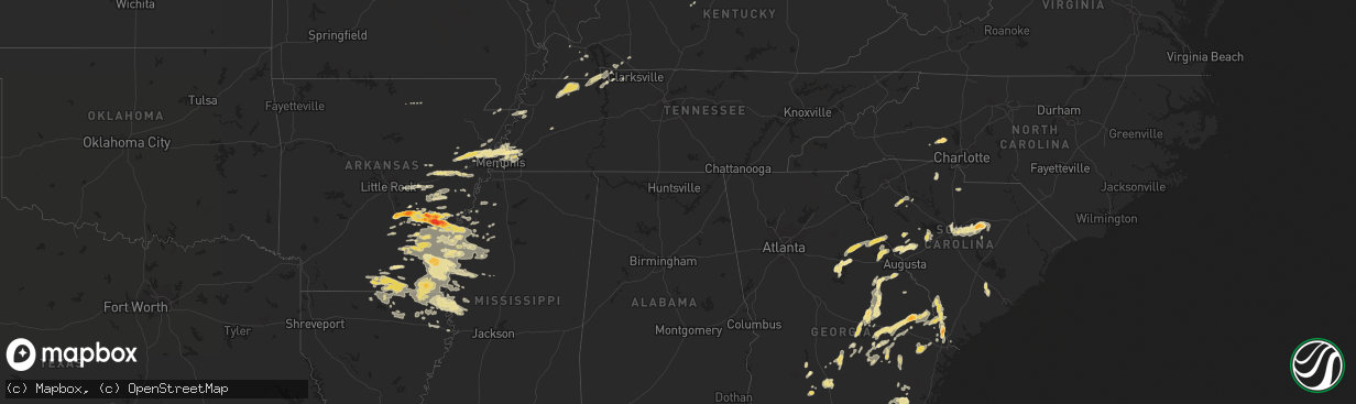
Hail Map in Georgia on September 25, 2011
The weather event in Georgia on September 25, 2011 includes Hail map. 15 states and 431 cities were impacted and suffered possible damage. The total estimated number of properties impacted is 0.
Want more than just the map?
Turn this storm into a full workflow.
- Owner + property data so you know who to knock
- OnDemand branded weather history reports to win the "did we even have hail?" argument
- RoofTrace estimate so reps stop guessing numbers at the door
Bought this map? Upgrade within 7 days and we'll credit the $230. (10-15 min setup call)
Hail
0
Estimated number of impacted properties by a 1.00" hail or larger0
Estimated number of impacted properties by a 1.75" hail or larger0
Estimated number of impacted properties by a 2.50" hail or largerStorm reports in Georgia
Georgia
| Date | Description |
|---|---|
| 09/25/20114:45 PM CDT | The 911 call center received 2 reports of trees down that were blocking canney bay and jess allen roads. The time given was based on radar. |
| 09/25/20113:35 PM CDT | Trees and power lines were damaged at the intersection of evelyn road and frank j. Culpepper road. |
| 09/25/20113:25 PM CDT | Mobile home trailer was turned over with roof damage also to storage and office buildings. |
| 09/25/20113:11 PM CDT | One tree down near highway 21 and eureka road. Time estimated by radar. |
| 09/25/20113:07 PM CDT | One tree down along union church road and windmill road. Time estimated by radar. |
| 09/25/20112:45 PM CDT | Several 3 inch diamater magnolia tree limbs down. Also received penny size hail. |
| 09/25/20112:34 PM CDT | Bulloch 911 center reports numerous large trees and power lines down. |
| 09/25/20112:29 PM CDT | Bulloch 911 center reports a large tree down on a house on lakeview road. The house sustained enough damage where the occupants are being sheltered by the red cross. |
| 09/25/20112:26 PM CDT | Possible tornado. The tops sheared off large and very tall pine trees. Some people reported that the wind was blowing from one direction than abruptly changed and was b |
| 09/25/20112:26 PM CDT | One large tree limb fell into lakeview baptist church. |
| 09/25/20112:25 PM CDT | Bulloch 911 center reports considerable hail damage across the northern part of the county. |
| 09/25/20112:25 PM CDT | Large tree down on lakeview baptist church. |
| 09/25/20112:19 PM CDT | A 50 feet tree fell and caused minor damage to a backyard deck. The tree created a large hole in the backyard where the expansive roots came out of the ground. |
| 09/25/20112:02 PM CDT | A local report indicates 1.75 inch wind near RINCON |
| 09/25/20111:50 PM CDT | 60 pecan trees downed at 4940 hwy 23 north. Time estimated by radar. |
| 09/25/20111:45 PM CDT | Numerous trees on power lines on cedar street. Time estimated by radar. |
| 09/25/20111:27 PM CDT | Time estimated by radar |
| 09/25/20111:27 PM CDT | Two large tree limbs down on a car. Estimates winds of 70 mph. |
All States Impacted by Hail Map on September 25, 2011
Cities Impacted by Hail Map on September 25, 2011
- White Plains, GA
- Greensboro, GA
- Green Cove Springs, FL
- Rochelle, GA
- Fitzgerald, GA
- Rhine, GA
- Abbeville, GA
- Sardis, MS
- Crenshaw, MS
- Edgefield, SC
- Kingsland, GA
- Kings Bay, GA
- Saint Marys, GA
- Anguilla, MS
- Hollandale, MS
- White Hall, AR
- Altheimer, AR
- Sherrill, AR
- Hazlehurst, GA
- Monroe, LA
- Sterlington, LA
- Millington, TN
- Lincolnton, NC
- Oakfield, GA
- Warwick, GA
- Benoit, MS
- Dermott, AR
- Lake Village, AR
- Eatonton, GA
- Wilmar, AR
- Monticello, AR
- Sharon, SC
- York, SC
- Knightstown, IN
- Spiceland, IN
- Boyle, MS
- Cleveland, MS
- Shaw, MS
- Wrightsville, GA
- East Dublin, GA
- Adrian, GA
- Milan, GA
- McRae Helena, GA
- Finley, TN
- Bragg City, MO
- Dalzell, SC
- Sumter, SC
- Rembert, SC
- Nahunta, GA
- Pine Bluff, AR
- Clyo, GA
- Garnett, SC
- Avera, GA
- Stapleton, GA
- Louisville, GA
- Arkansas City, AR
- Portland, AR
- McGehee, AR
- Rentz, GA
- Dublin, GA
- Piedmont, OH
- Quaker City, OH
- Barnesville, OH
- Freeport, OH
- Hopkins, SC
- Columbia, SC
- Eastover, SC
- Estill, SC
- Luray, SC
- Coahoma, MS
- Cherryville, NC
- Lawndale, NC
- Dover, TN
- Arlington, TN
- Fort Lawn, SC
- Richburg, SC
- Lancaster, SC
- Hermitage, AR
- Springfield, GA
- Rincon, GA
- Williston, FL
- Batesburg, SC
- Leesville, SC
- Buchanan, TN
- New Concord, KY
- Doddsville, MS
- Earle, AR
- Dresden, TN
- Paris, TN
- Palmersville, TN
- Mayersville, MS
- Transylvania, LA
- Lake Providence, LA
- Oak Grove, LA
- Rolling Fork, MS
- Cary, MS
- De Witt, AR
- Almyra, AR
- Stuttgart, AR
- Indianola, MS
- Brinkley, AR
- Carlisle, AR
- Tifton, GA
- Alamo, GA
- New Castle, IN
- Sharon, TN
- Cottage Grove, TN
- Martin, TN
- Goodwin, AR
- Cotton Plant, AR
- Wheatley, AR
- Palestine, AR
- Joiner, AR
- Tyronza, AR
- Ridgeville, SC
- Holly Grove, AR
- Casscoe, AR
- Roe, AR
- Clarendon, AR
- Jones, LA
- Hamburg, AR
- Eudora, AR
- Wilmot, AR
- Bonita, LA
- Parkdale, AR
- El Dorado, AR
- Drew, MS
- Ruleville, MS
- Eads, TN
- Hazen, AR
- Herndon, KY
- Bartow, GA
- Wadley, GA
- Kite, GA
- Sylvania, GA
- Lewisville, OH
- Poplar Bluff, MO
- Wabbaseka, AR
- Soperton, GA
- Tarrytown, GA
- Vidalia, GA
- Old Town, FL
- Baxley, GA
- Fargo, GA
- De Valls Bluff, AR
- Hardeeville, SC
- Blythe, GA
- Hephzibah, GA
- Laurens, SC
- Greenville, MS
- Beulah, MS
- Rohwer, AR
- Clinton, SC
- Tichnor, AR
- Gillett, AR
- Glennville, GA
- Odum, GA
- Memphis, TN
- De Leon Springs, FL
- Pierson, FL
- Drummonds, TN
- Enigma, GA
- Saint Charles, AR
- Elaine, AR
- Ethel, AR
- Crossett, AR
- Fernandina Beach, FL
- Fort Stewart, GA
- Pembroke, GA
- Waycross, GA
- Thomson, GA
- Appling, GA
- Lincolnton, GA
- Hopkinsville, KY
- Statesboro, GA
- Portal, GA
- Wrens, GA
- Archer, FL
- North Augusta, SC
- Clarks Hill, SC
- Trenton, SC
- Johnston, SC
- Bloomingdale, GA
- Guyton, GA
- Saint Marys, WV
- Davisboro, GA
- Twin City, GA
- Swainsboro, GA
- Lyons, GA
- Metter, GA
- Marion, LA
- Rayle, GA
- Union Point, GA
- Humphrey, AR
- McConnells, SC
- Dumas, AR
- Grady, AR
- Star City, AR
- Turrell, AR
- Shelby, MS
- Duncan, MS
- Gunnison, MS
- Snow Lake, AR
- Huttig, AR
- Strong, AR
- Lake Park, GA
- Marion, AR
- Wynne, AR
- Crawfordsville, AR
- Parkin, AR
- Mount Vernon, GA
- Uvalda, GA
- Ailey, GA
- Fairdale, KY
- Brooks, KY
- Shepherdsville, KY
- Louisville, KY
- Puryear, TN
- Reidsville, GA
- Wappapello, MO
- McGee, MO
- Jersey, AR
- Tignall, GA
- Washington, GA
- McCormick, SC
- Sylvester, GA
- Hughes, AR
- Forrest City, AR
- Collins, GA
- Gilbert, SC
- Waynesboro, GA
- Parchman, MS
- Tutwiler, MS
- Saluda, SC
- Newington, GA
- Cobbtown, GA
- Lugoff, SC
- Sledge, MS
- Dundee, MS
- Yazoo City, MS
- Evening Shade, AR
- Big Rock, TN
- Bumpus Mills, TN
- Orwell, OH
- Middlefield, OH
- Windsor, OH
- Richland, IN
- Warren, AR
- Leland, MS
- Rockledge, GA
- Modoc, SC
- Grandin, MO
- Ellsinore, MO
- Williamsville, MO
- Chauncey, GA
- Jennings, FL
- Bronson, FL
- Summerville, SC
- Farmerville, LA
- Troy, SC
- Stewart, TN
- Big Sandy, TN
- Morriston, FL
- Keysville, GA
- Pickens, AR
- Tillar, AR
- Winchester, AR
- Rayville, LA
- Oak Ridge, LA
- Rison, AR
- Chatham, MS
- Glen Allan, MS
- Carthage, IN
- Marianna, AR
- Des Arc, AR
- Saint George, GA
- Register, GA
- Port Wentworth, GA
- Augusta, AR
- Boonville, IN
- Tennyson, IN
- Rosedale, MS
- Watson, AR
- Mound Bayou, MS
- Branford, FL
- Pioneer, LA
- Epps, LA
- Hoboken, GA
- Folkston, GA
- Woodlawn, TN
- Indian Mound, TN
- Chrisney, IN
- Paducah, KY
- High Springs, FL
- Alachua, FL
- Savannah, GA
- Tillman, SC
- Fairfax, SC
- Pineland, SC
- Lonoke, AR
- Scott, AR
- Blytheville, AR
- Patterson, GA
- Minter City, MS
- Lake Butler, FL
- Matthews, GA
- Dorchester, SC
- Sanderson, FL
- Schlater, MS
- Caruthersville, MO
- Hornersville, MO
- Steele, MO
- Cruger, MS
- Valley Park, MS
- Lambert, MS
- Neelyville, MO
- Burton, OH
- Hilliard, FL
- Clarksdale, MS
- Lamar, IN
- Symsonia, KY
- Benton, KY
- Spencer, WV
- Elizabeth, WV
- Reedy, WV
- Palestine, WV
- Creston, WV
- Montrose, AR
- Bastrop, LA
- Inverness, MS
- Isola, MS
- Mer Rouge, LA
- Ripley, TN
- Hazel, KY
- Gibson, GA
- Lexa, AR
- Ashburn, GA
- Atoka, TN
- Macclenny, FL
- Glen Saint Mary, FL
- Hortense, GA
- Screven, GA
- Doerun, GA
- Moultrie, GA
- Leachville, AR
- Merigold, MS
- Woodsfield, OH
- Grandview, IN
- Patton, MO
- Sedgewickville, MO
- Charleston, MS
- Maiden, NC
- Crouse, NC
- Denver, NC
- Iron Station, NC
- Cecilia, KY
- Sandersville, GA
- Tallulah, LA
- Griffithville, AR
- Greenfield, TN
- Cadwell, GA
- Van Buren, MO
- Henderson, KY
- Fountain Hill, AR
- Aiken, SC
- Ridge Spring, SC
- Shaw Afb, SC
- Mayesville, SC
- Bishopville, SC
- Camden, SC
- Wedgefield, SC
- Blythewood, SC
- Rebecca, GA
- Aubrey, AR
- Sumner, GA
- Du Pont, GA
- Stockton, GA
- Bells, TN
- Cordova, TN
- Colt, AR
- Mason, TN
- Munford, TN
- England, AR
- Gleason, TN
- Santa Claus, IN
- Dexter, MO
- Bernice, LA
- Verona, WI
- Delhi, LA
- West Monroe, LA
- Ellabell, GA
- Ferdinand, IN
- Graysville, OH
- Newport, OH
- New Matamoras, OH
- Dukedom, TN
- Fulton, KY
- Rockport, IN
- Murray, KY
- Horseshoe Bend, AR
- Big Clifty, KY
- Alligator, MS
- Poulan, GA
- Hampton, AR
- Melbourne, AR
- Marquand, MO
- Greenwood, MS
- Belzoni, MS
- Sunflower, MS
- Gould, AR
- Spearsville, LA
- Seymour, IN
- Cherry Valley, AR
- Cadiz, KY
- Lyons, MI
- Itta Bena, MS
- Trenton, FL
- Newberry, FL
- Fort White, FL
- Lumber City, GA
- Glenwood, GA
- Sparta, GA
- Franklin, AR
- Lake City, FL
- Sage, AR
- West Helena, AR
- Vine Grove, KY
- Radcliff, KY
- West Point, KY
- Fort Knox, KY
- Rineyville, KY


