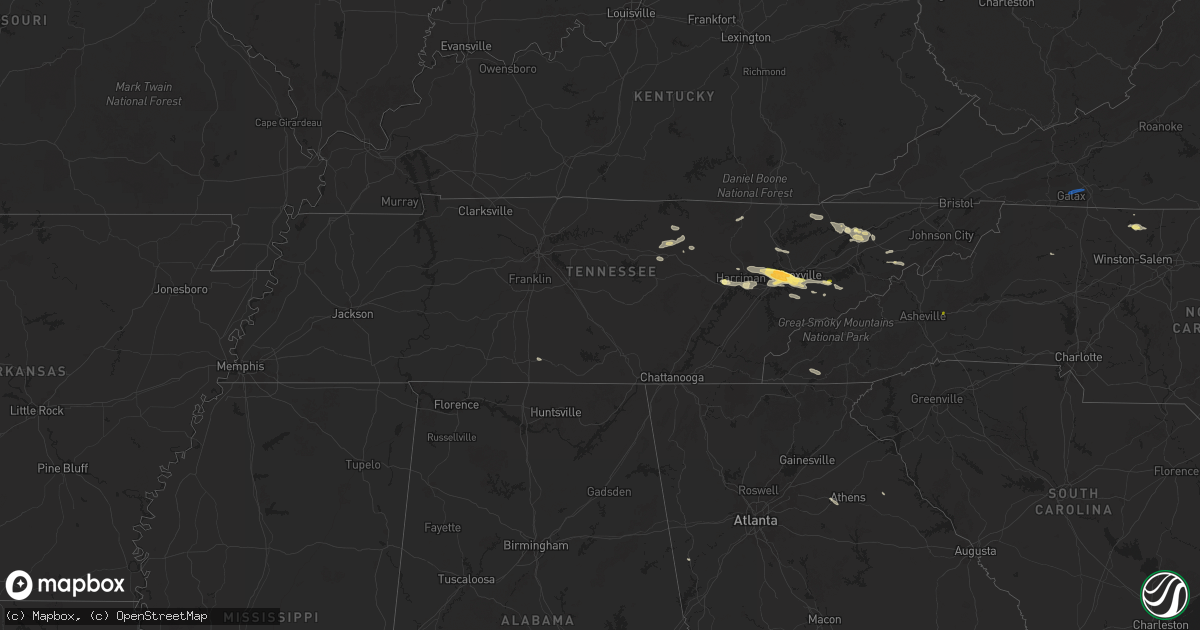
Hail Map in Tennessee on September 4, 2025
Get this storm
September 4 map
$229
one time, instant access
Download today. No call, no setup
Keep the $229
Bought the map and want the full workflow? Apply the entire $229 to a subscription within 7 days. None of it is wasted.
Every map, not just this one
This buys you this map. Subscription and you get every map we run, in the markets you choose from a few cities to whole states to nationwide. Plus real-time alerts the moment a storm fires.
Contact data
Name, contact info, occupancy, even credit band for addresses in the footprint. You go from where it hit to who to call.
Become the source they trust
Unlimited branding weather history reports on demand. You already have the documented answer ready for the property owner, and you are the one who showed up with it.
Property data and RoofTrace estimates
Pull up any address you have got, its value and the exact code rules for that jurisdiction, straight from One Click Code. Then RoofTrace estimates the squares, pitch, and roof value, priced the way you price.
Storm reports in Tennessee
Tennessee
| Date | Description |
|---|---|
| 09/04/20253:00 PM CDT | A local report indicates 1.00 inch wind near 2 NNW Bradbury |
| 09/04/20252:50 PM CDT | Tree limbs down. |
| 09/04/20252:20 PM CDT | Several trees knocked down around mooresburg. |
| 09/04/20252:20 PM CDT | Several trees knocked down around mooresburg. |
| 09/04/20251:57 PM CDT | Report from mping: quarter |
| 09/04/20251:57 PM CDT | Report from mping: qu |
| 09/04/20251:55 PM CDT | Social media photo of large tree down across the road. Time estimated based on radar. |
| 09/04/20251:45 PM CDT | Large tree down over power lines. |
| 09/04/20251:40 PM CDT | Trees down around walter state college. |
| 09/04/20251:35 PM CDT | Social media video of dime to quarter size hail... Time estimated based on radar. |
| 09/04/20251:30 PM CDT | A local report indicates 1.00 inch wind near 1 N Tazewell |
| 09/04/20251:30 PM CDT | Large tree branch |
| 09/04/20251:07 PM CDT | Report from mping: quarter |
| 09/04/202512:35 PM CDT | A local report indicates 1.50 inch wind near 1 ENE Karns |
| 09/04/202512:35 PM CDT | Social media photo of multiple golf ball size hail stones. |
| 09/04/202512:30 PM CDT | Broadcast media report of half dollar size hail off of solway road. Similar report in karns. |
| 09/04/202512:30 PM CDT | Nickel to quarter-sized hail near hardin valley area. |
| 09/04/202512:10 PM CDT | A local report indicates 1.00 inch wind near 4 NE Cedar Creek |
| 09/04/202512:00 PM CDT | Trees blown down onto power lines. |
| 09/04/202511:55 AM CDT | Report of trees and powerlines down near fairview rd and coalfield school. Currently does not look to be located near where the funnel cloud was reported. |
| 09/04/202511:30 AM CDT | Social media photos of downed trees and power lines. Time estimated based on radar. |
| 09/04/202511:25 AM CDT | Trees down across cedar creek rd. |
| 09/04/202510:00 AM CDT | Reports of several trees down along cedar fork road east of tazewell. |
All States Impacted by Hail Map on September 4, 2025
Cities Impacted by Hail Map on September 4, 2025
- Butler, MO
- Adrian, MO
- Archie, MO
- Drexel, MO
- Greeneville, TN
- Oak Ridge, TN
- Oliver Springs, TN
- Knoxville, TN
- Clinton, TN
- Harriman, TN
- Speedwell, TN
- Lenoir City, TN
- Monterey, TN
- New Tazewell, TN
- Seymour, TN
- Louisville, TN
- Sevierville, TN
- Clarkrange, TN
- Wilkesboro, NC
- Morristown, TN
- Thorn Hill, TN
- Tazewell, TN
- Cookeville, TN
- Washburn, TN
- Bean Station, TN
- Rockford, TN
- Farragut, TN
- Galax, VA
- Woodlawn, VA
- Mooresburg, TN
- Russellville, TN
- Rutledge, TN
- Maryville, TN
- Rocky Top, TN
- Briceville, TN
- Frankewing, TN
- King, NC
- Westfield, NC
- Walnut Cove, NC
- Whitesburg, TN
- Danbury, NC
- Lawsonville, NC
- Rockwood, TN
- Germanton, NC
- Bulls Gap, TN
- Fayetteville, TN
- Petersburg, TN
- Kingston, TN
- Heiskell, TN
- Amargosa Valley, NV
- Rickman, TN
- Yucca, AZ
- Dolan Springs, AZ
- Santa Ysabel, CA
- Julian, CA
- Alton, VA
- South Boston, VA
- Prescott, AZ
- Livingston, TN
- Franklin, GA
- Roopville, GA
- Crawford, TN
- Virgilina, VA
- Alcoa, TN
- Black Mountain, NC
- Helenwood, TN
- Buffalo Junction, VA
- Clarksville, VA
- Statham, GA
- Bogart, GA
- Carlton, GA
- Maricopa, AZ
- Pine Valley, CA
- Campo, CA
- Watkinsville, GA
- Marshall, MN
- Vesta, MN
- Lucan, MN
- Milroy, MN
- Wabasso, MN
- Lamberton, MN
- Revere, MN
- Walnut Grove, MN
- Tracy, MN
- Oneida, TN
- Balaton, MN
- Garvin, MN
- Slayton, MN
- Lake Wilson, MN
- Currie, MN
- Avoca, MN
- Dovray, MN
- Westbrook, MN
- Redwood Falls, MN
- Wanda, MN
- Springfield, MN
- Clements, MN
- Morgan, MN
- Storden, MN
- Sanborn, MN
- Morton, MN
- Fairfax, MN
- Franklin, MN
- Jeffers, MN
- Sleepy Eye, MN
- Meadview, AZ
- New Ulm, MN
- Lafayette, MN
- Winthrop, MN
- Gibbon, MN
- Courtland, MN
- Gaylord, MN
- Nicollet, MN
- Saint Peter, MN
- Arlington, MN
- Henderson, MN
- Le Sueur, MN
- Mankato, MN
- Hackberry, AZ
- Bullhead City, AZ
- Kasota, MN
- Cleveland, MN
- Hayesville, NC
- Le Center, MN
- Hawthorne, NV
- Caliente, NV
- Roll, AZ
- Wellton, AZ
- Golden Valley, AZ
- Yuma, AZ
- Buffalo, OK
- Minneola, KS
- Mooreland, OK
- Scott City, KS
- Healy, KS
- Dighton, KS
- Waynoka, OK
- Cimarron, KS
- Ringwood, OK
- Enid, OK
- Chandler, OK
- Davenport, OK
- Somerton, AZ
- Mosheim, TN
- Oakdale, TN


