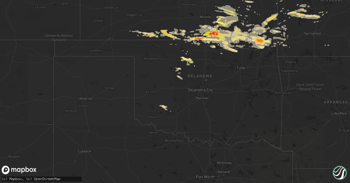
Hail Map in Oklahoma on September 1, 2014
Get this storm
September 1 map
$229
one time, instant access
Download today. No call, no setup
Keep the $229
Bought the map and want the full workflow? Apply the entire $229 to a subscription within 7 days. None of it is wasted.
Every map, not just this one
This buys you this map. Subscription and you get every map we run, in the markets you choose from a few cities to whole states to nationwide. Plus real-time alerts the moment a storm fires.
Contact data
Name, contact info, occupancy, even credit band for addresses in the footprint. You go from where it hit to who to call.
Become the source they trust
Unlimited branding weather history reports on demand. You already have the documented answer ready for the property owner, and you are the one who showed up with it.
Property data and RoofTrace estimates
Pull up any address you have got, its value and the exact code rules for that jurisdiction, straight from One Click Code. Then RoofTrace estimates the squares, pitch, and roof value, priced the way you price.
Storm reports in Oklahoma
Oklahoma
| Date | Description |
|---|---|
| 09/01/20146:24 PM CDT | A local report indicates 2.75 inch wind near 7 NW WELCH |
| 09/01/20146:24 PM CDT | A local report indicates 2.75 inch wind near 7 NW HOLLOW |
| 08/31/201410:37 PM CDT | Few large tree limbs down. Roof damage to mobile home. |
| 08/31/201410:35 PM CDT | Numerous reports of damage in and around pyramid corners...including large trees and limbs down...shingles removed from roofs...and small metal shed destroyed. |
| 08/31/201410:24 PM CDT | A local report indicates 67 MPH wind near 7 E CENTRAILIA |
| 08/31/20149:45 PM CDT | Shingles blown off of roof and the tin roof of a barn was peeled back on a rural property east of dewey. Time estimated by radar. |
| 08/31/20149:25 PM CDT | A local report indicates 80 MPH wind near BARTLESVILLE |
| 08/31/20149:05 PM CDT | A local report indicates 73 MPH wind near 8 ESE FORAKER |
| 08/31/20149:00 PM CDT | A local report indicates 1.00 inch wind near 2 W ENID |
| 08/31/20148:58 PM CDT | A local report indicates 1.00 inch wind near 2 NW ENID |
| 08/31/20148:28 PM CDT | In chilocco up to kansas border. |
| 08/31/20148:15 PM CDT | A local report indicates 1.00 inch wind near 2 W ENID |
| 08/31/20147:30 PM CDT | A local report indicates 1.75 inch wind near 1 E LAHOMA |
| 08/31/20147:27 PM CDT | A local report indicates 1.00 inch wind near LAHOMA |
| 08/31/20147:15 PM CDT | A local report indicates 1.75 inch wind near 5 S GOLTRY |
All States Impacted by Hail Map on September 1, 2014
Cities Impacted by Hail Map on September 1, 2014
- West Alton, MO
- Florissant, MO
- Independence, KS
- Rock, KS
- Gridley, KS
- Le Roy, KS
- Westphalia, KS
- Burlington, KS
- Dunnegan, MO
- Humansville, MO
- Bolivar, MO
- Nevada, MO
- Deerfield, MO
- Hawley, MN
- Leon, KS
- Latham, KS
- Ballwin, MO
- Cambridge, KS
- Grenola, KS
- Augusta, KS
- Howard, KS
- Severy, KS
- Fall River, KS
- Piedmont, KS
- Douglass, KS
- Atlanta, KS
- Tyro, KS
- Havana, KS
- Caney, KS
- Pawhuska, OK
- Copan, OK
- Niotaze, KS
- Chautauqua, KS
- Sedan, KS
- Peru, KS
- Ottawa, KS
- Oxford, KS
- Geuda Springs, KS
- Winfield, KS
- Welch, OK
- Coffeyville, KS
- S Coffeyville, OK
- Chetopa, KS
- Edna, KS
- Bartlett, KS
- Meno, OK
- Goltry, OK
- Lahoma, OK
- Roosevelt, OK
- Vinita, OK
- Bluejacket, OK
- Virgil, KS
- Alva, OK
- Ashland, KS
- Lindale, GA
- Rantoul, KS
- Osceola, MO
- Nisswa, MN
- Brainerd, MN
- Eldridge, MO
- Bushnell, FL
- Stockton, MO
- Hazelton, KS
- Okeene, OK
- Sharon, KS
- Holden, MO
- Clinton, MO
- Blairstown, MO
- Calhoun, MO
- Leeton, MO
- Chilhowee, MO
- Windsor, MO
- Bonita Springs, FL
- Eureka, MO
- Lenapah, OK
- Mound Valley, KS
- Cherryvale, KS
- Perham, MN
- Kaycee, WY
- El Dorado Springs, MO
- Milo, MO
- Elkland, MO
- Buffalo, MO
- Columbia, SC
- Oswego, KS
- Altamont, KS
- Parsons, KS
- Caldwell, KS
- Ponca City, OK
- Edwardsville, IL
- Eureka, KS
- El Dorado, KS
- Osakis, MN
- Villard, MN
- Sauk Centre, MN
- Enid, OK
- Hepler, KS
- Fort Scott, KS
- Garland, KS
- Farlington, KS
- Girard, KS
- Arcadia, KS
- Walnut, KS
- Andrews, SC
- Lamar, MO
- West Union, MN
- Garfield, MN
- Alexandria, MN
- Spring Hill, KS
- Wann, OK
- Miami, OK
- Wyandotte, OK
- Gardner, KS
- Coldwater, KS
- Englewood, KS
- Protection, KS
- Cedar Vale, KS
- Fredonia, KS
- Saint George, SC
- Cape Charles, VA
- Valentine, NE
- Harrisonville, MO
- Saint Louis, MO
- Newkirk, OK
- Braman, OK
- Attica, KS
- Anthony, KS
- Yates Center, KS
- Neosho Falls, KS
- Pine Ridge, SD
- Granby, MO
- Neosho, MO
- Bucyrus, KS
- New Century, KS
- Olathe, KS
- Half Way, MO
- Flemington, MO
- Louisburg, MO
- Polk, MO
- Belle Plaine, KS
- Hobart, OK
- Gotebo, OK
- Quapaw, OK
- Jackson, GA
- Barnesville, GA
- Forsyth, GA
- Burns, KS
- Wellsville, KS
- Paola, KS
- Gordon, NE
- Merriman, NE
- Argonia, KS
- Danville, KS
- Montgomery City, MO
- Hitchcock, OK
- Wildwood, MO
- High Ridge, MO
- Valley Park, MO
- Fenton, MO
- Fairfax, OK
- Medicine Lodge, KS
- Granite City, IL
- Saint Paul, KS
- Bluff City, KS
- Wellington, KS
- Arnold, MO
- South Haven, KS
- Lawton, OK
- Mountain View, OK
- Medford, OK
- Elk City, KS
- Longton, KS
- Elk Falls, KS
- McCune, KS
- Maple City, KS
- Dexter, KS
- Udall, KS
- Burden, KS
- Shidler, OK
- Bartlesville, OK
- Barnsdall, OK
- Arkansas City, KS
- Burbank, OK
- Manchester, OK
- Eudora, KS
- Edgerton, KS
- Gwynn, VA
- Hudgins, VA
- Quincy, MO
- Pillager, MN
- Motley, MN
- Pequot Lakes, MN
- Jasper, MO
- Oronogo, MO
- Carthage, MO
- Liberal, MO
- Whitman, NE
- Watonga, OK
- Hemingford, NE
- Hay Springs, NE
- Rushville, NE
- Pocahontas, IL
- New Douglas, IL
- Wheatland, MO
- New Florence, MO
- Kaw City, OK
- Harper, KS
- Alapaha, GA
- Baxter, MN
- Salters, SC
- Douglas, OK
- Warrensburg, MO
- Highland, IL
- Piqua, KS
- Nelson, MN
- Hardtner, KS
- Lake City, KS
- Kiowa, KS
- Towanda, KS
- Clarksburg, MO
- California, MO
- Bunceton, MO
- Prairie Home, MO
- Florence, MO
- Mora, MO
- Otterville, MO
- Tipton, MO
- Syracuse, MO
- Smithton, MO
- Stover, MO
- Versailles, MO
- Fortuna, MO
- Kilmarnock, VA
- Waukomis, OK
- Isle, MN
- Butler, MO
- Foster, MO
- Peck, KS
- Johnstown, NE
- Saint Peter, IL
- Weaubleau, MO
- Collins, MO
- Grenville, SD
- Weir, KS
- Carl Junction, MO
- Scammon, KS
- Galena, KS
- Columbus, KS
- Pittsburg, KS
- Webb City, MO
- Asbury, MO
- Ringwood, OK
- Drummond, OK
- Helena, OK
- Fairmont, OK
- Carrier, OK
- Roslyn, SD
- Currie, NC
- Defiance, MO
- Gray Summit, MO
- Labadie, MO
- Imperial, MO
- Washington, MO
- Chesterfield, MO
- Dupo, IL
- Augusta, MO
- Columbia, IL
- Pacific, MO
- Saint Albans, MO
- House Springs, MO
- East Carondelet, IL
- Villa Ridge, MO
- Dennis, KS
- Green Ridge, MO
- Burwell, NE
- Edgewood, IL
- Farina, IL
- Fairland, OK
- Freeman, MO
- Peculiar, MO
- Rhine, GA
- Milan, GA
- Nashville, GA
- Ray City, GA
- Long Lane, MO
- Fowler, KS
- Fair Play, MO
- Dearing, KS
- Moline, KS
- Delaware, OK
- Liberty, KS
- Hudson, IA
- Waterloo, IA
- Williamsburg, MO
- New Baden, IL
- Broxton, GA
- Carterville, MO
- Joplin, MO
- Opolis, KS
- Centerview, MO
- Kingfisher, OK
- Cape Coral, FL
- Ulen, MN
- Chula, GA
- Dewey, OK
- Greenville, IL
- Bartlett, NE
- Galesburg, KS
- Amelia, NE
- Humboldt, KS
- Sun City, KS
- Newnan, GA
- Fort Myers Beach, FL
- Fort Myers, FL
- Elgin, SC
- Jacksonville, GA
- Jerico Springs, MO
- Sheldon, MO
- Seneca, MO
- Reeds, MO
- Burlington, OK
- Waldron, KS
- Millstadt, IL
- Callaway, MN
- Knob Noster, MO
- Garden City, MO
- Savonburg, KS
- Clearwater, KS
- East Saint Louis, IL
- Aragon, GA
- Cedartown, GA
- Fairview, MO
- Stella, MO
- Meridian, OK
- Guthrie, OK
- Valdosta, GA
- Farwell, MN
- Neodesha, KS
- Thayer, KS
- Ava, MO
- Tunas, MO
- Hahira, GA
- East Alton, IL
- Alton, IL
- Saint Charles, MO
- Sarcoxie, MO
- Rocky Point, NC
- Conway Springs, KS
- Milan, KS
- Mulvane, KS
- Cassoday, KS
- Treece, KS
- Beaumont, KS
- Bronaugh, MO
- Picher, OK
- Commerce, OK
- North Miami, OK
- Rosalia, KS
- Arma, KS
- Mayfield, KS
- Cherokee, KS
- Amorita, OK
- Baxter Springs, KS
- Nash, OK
- Rome, GA
- Dent, MN
- Freeport, KS
- Lebanon, MO
- Richards, MO
- Southard, OK
- Fort White, FL
- Sutherland, NE
- Cave Spring, GA
- Prescott, KS
- Toronto, KS
- Douglas, WY
- Alhambra, IL
- Glyndon, MN
- Cherokee, OK
- Robinson, IL
- Junction City, KS
- Grantville, GA
- Centertown, MO
- Altoona, KS
- Creighton, MO
- Urich, MO
- Gettysburg, SD
- Jet, OK
- Wood River, IL
- Hartford, IL
- Roxana, IL
- South Roxana, IL
- Cleveland, MO
- Walker, MO
- Blackville, SC
- Barnwell, SC
- Riverton, KS
- Diamond, MO
- Jonesburg, MO
- Wilmore, KS
- Mindenmines, MO
- Buffalo, KS
- Interior, SD
- Scenic, SD
- Wanblee, SD
- Carlos, MN
- Brandon, MN
- Portage Des Sioux, MO
- Louisburg, KS
- Alma, KS
- Maple Hill, KS
- Berryton, KS
- Topeka, KS
- Paxico, KS
- McFarland, KS
- Baldwin City, KS
- Lawrence, KS


