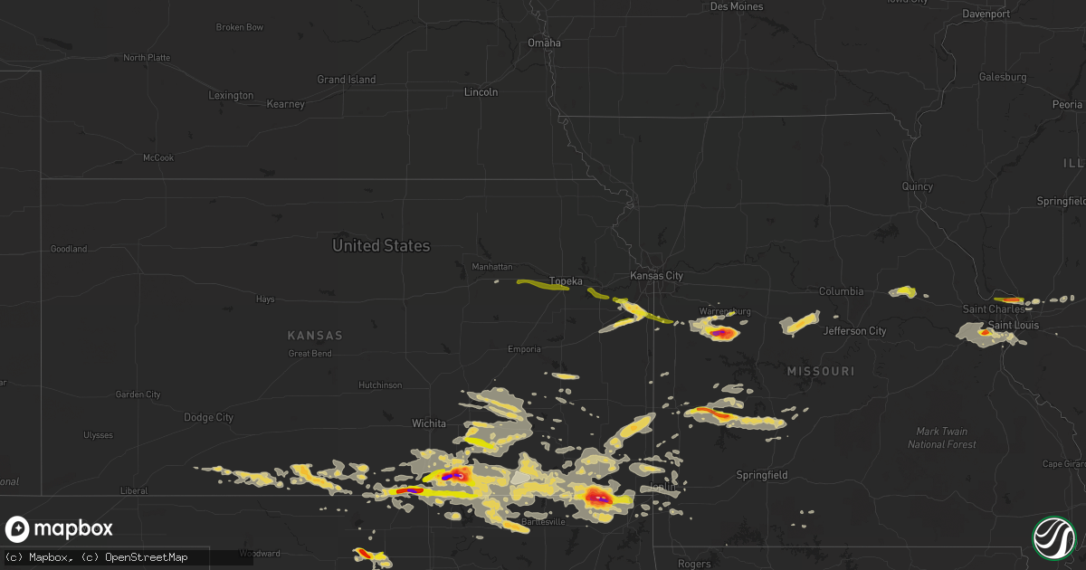
Hail Map on September 1, 2014
Get this storm
September 1 map
$229
one time, instant access
Download today. No call, no setup
Keep the $229
Bought the map and want the full workflow? Apply the entire $229 to a subscription within 7 days. None of it is wasted.
Every map, not just this one
This buys you this map. Subscription and you get every map we run, in the markets you choose from a few cities to whole states to nationwide. Plus real-time alerts the moment a storm fires.
Contact data
Name, contact info, occupancy, even credit band for addresses in the footprint. You go from where it hit to who to call.
Become the source they trust
Unlimited branding weather history reports on demand. You already have the documented answer ready for the property owner, and you are the one who showed up with it.
Property data and RoofTrace estimates
Pull up any address you have got, its value and the exact code rules for that jurisdiction, straight from One Click Code. Then RoofTrace estimates the squares, pitch, and roof value, priced the way you price.
States Impacted by Hail Map on September 1, 2014
Storm reports
Florida
| Date | Description |
|---|---|
| 09/01/20143:18 PM CDT | Public sent picture of downed tree on three oaks parkway 1/4 mile north of estero parkway via social media. Time estimated from radar. |
Minnesota
| Date | Description |
|---|---|
| 09/01/20146:13 PM CDT | Quarter sized hail reported in alexandria via twitter. |
| 09/01/20146:10 PM CDT | A local report indicates 1.00 inch wind near 2 WNW HAWLEY |
| 09/01/20145:40 PM CDT | Second of two hail producing storms resulted in dime to quarter sized hail coating the ground. |
| 09/01/20145:30 PM CDT | A local report indicates 1.00 inch wind near 3 SW CARLOS |
| 08/31/20148:26 PM CDT | Largest hail size quarters...with lots of pennies covering the ground. |
South Carolina
| Date | Description |
|---|---|
| 09/01/20146:07 PM CDT | Barnwell dispatch reported multiple trees and power lines down near the intersection of highway 3 and palimino ln. |
| 09/01/20145:46 PM CDT | Fort jackson reported two trees down along with several power outages. |
| 09/01/20145:29 PM CDT | Sc highway patrol reported trees blocking roadways in the vicinity of i20 and clemson rd. |
| 09/01/20145:24 PM CDT | Public reported multiple trees down in woods near apartment complex. |
Kansas
| Date | Description |
|---|---|
| 09/01/20146:48 PM CDT | Via eoc |
| 09/01/20146:47 PM CDT | Via spotter network |
| 09/01/20146:44 PM CDT | Hail ranged in size from three quarters of an inch to one inch. |
| 09/01/20146:42 PM CDT | A local report indicates 1.25 inch wind near 1 S EDNA |
| 09/01/20146:38 PM CDT | A local report indicates 1.25 inch wind near 9 SW WINFIELD |
| 09/01/20146:36 PM CDT | A local report indicates 1.00 inch wind near 3 N GEUDA SPRINGS |
| 09/01/20146:14 PM CDT | A local report indicates 1.00 inch wind near 15 SE WELLINGTON |
| 08/31/201410:55 PM CDT | Also reported 60 mph winds using web report. |
| 08/31/201410:27 PM CDT | A local report indicates 1.50 inch wind near SPRING HILL |
| 08/31/201410:25 PM CDT | A local report indicates 1.00 inch wind near EUREKA |
| 08/31/20149:47 PM CDT | Report of several trees... Limbs... And power lines down around the parsons... Big hill... And mound valley. |
| 08/31/20148:45 PM CDT | Emergency manager reported possible home damage in the town of hewins... Which is around 8 miles west-northwest of elgin. |
| 08/31/20148:45 PM CDT | Estimated 70 to 80 mph. |
| 08/31/20148:36 PM CDT | Tree reported down across road near intersection of southwest quaker rd and southwest 30th street. County officials removed tree. |
| 08/31/20148:35 PM CDT | Tornado was reported 7 miles southeast of cedar vale via emergency management. |
| 08/31/20148:30 PM CDT | Relayed by em. |
| 08/31/20148:25 PM CDT | Tornado reported by chief of police and deputies in cedar vale. |
| 08/31/20148:20 PM CDT | Large tornado on the ground. |
| 08/31/20148:13 PM CDT | Brief rope tornado touchdown. Via eoc. |
| 08/31/20148:10 PM CDT | A local report indicates 1.00 inch wind near 12 W BAXTER SPRINGS |
| 08/31/20148:08 PM CDT | Chaser reported cone tornado on the ground. |
| 08/31/20148:08 PM CDT | Via eoc. |
| 08/31/20147:36 PM CDT | Tree reported down across road near intersection of southwest quaker rd and southwest 30th street. County officials removed tree. Corrected time. |
| 08/31/20147:33 PM CDT | Report via twitter. |
| 08/31/20147:25 PM CDT | Via twitter. |
| 08/31/20147:17 PM CDT | A local report indicates 60 MPH wind near 4 SW LATHAM |
| 08/31/20147:17 PM CDT | Via eoc. Nickel to quarter size hail. |
| 08/31/20147:00 PM CDT | A local report indicates 3.00 inch wind near 4 S WINFIELD |
South Dakota
| Date | Description |
|---|---|
| 09/01/20145:00 PM CDT | A local report indicates 1.00 inch wind near 8 SE EDEN |
| 09/01/20144:50 PM CDT | A local report indicates 60 MPH wind near INTERIOR |
| 09/01/20144:50 PM CDT | A local report indicates 1.00 inch wind near INTERIOR |
Michigan
| Date | Description |
|---|---|
| 09/01/20145:51 PM CDT | Numerous 3 inch tree limbs down in pine grove park. |
| 09/01/20145:50 PM CDT | Pictures of several large trees and limbs down in the vicinity of 11th and lyon were sent via facebook |
| 09/01/20145:06 PM CDT | Large trees...branches...and powerlines downed near armada center and kaine roads. |
| 09/01/20142:05 PM CDT | Trees and power lines down. Time estimated from radar |
| 09/01/20142:00 PM CDT | Tree down on power line and tree is on fire. |
| 09/01/20141:57 PM CDT | Trees down |
| 09/01/20141:57 PM CDT | House damaged. Trees and power lines down. Relayed from law enforcement. Possible tornado. |
| 09/01/20141:43 PM CDT | A national weather service storm survey confirmed an ef-0 tornado. Damage consisted of uprooted and snapped trees. The maximum winds were estimated at 80 mph. The path |
| 09/01/20141:42 PM CDT | A national weather service storm survey confirmed an ef-1 tornado. Damage consisted of uprooted hardwood trees and softwood trees with a number of these trees falling o |
| 09/01/20141:28 PM CDT | Trees and powerlines down. Caller reported seeing funnel cloud as well. |
| 09/01/20141:26 PM CDT | 1 medium-size tree down and over the road blocking 1 lane at s mission st and e millbrook just south of mt. Pleasant |
| 09/01/20141:26 PM CDT | 1 larger tree leaning on a house on s university ave. |
| 09/01/20141:16 PM CDT | A national weather service storm survey confirmed an ef-1 tornado. Damage consisted of uprooted and snapped trees as well as significant roof damage to one residence an |
| 09/01/20141:01 PM CDT | Possible tornado with a lot of trees and power lines down over northeastern portions of kalkaska county. |
| 09/01/201412:53 PM CDT | National weather service storm survey confirmed an ef-1 tornado. Damage consisted of mainly uprooted hardwood and softwood trees...with several residences damaged from |
| 09/01/201412:47 PM CDT | National weather service storm survey confirmed an ef-1 tornado. Damage consisted of mainly uprooted hardwood and softwood trees...with several residences damaged from |
Virginia
| Date | Description |
|---|---|
| 09/01/20142:54 PM CDT | Large tree limb down near the intersection of browns mill road and beulah road. |
Georgia
| Date | Description |
|---|---|
| 09/01/20146:00 PM CDT | Two trees reported down by crawford county 911. |
| 09/01/20145:50 PM CDT | A tree reportedly fell on a car on avera road. |
| 09/01/20145:40 PM CDT | Tree fell on a car along avera road |
| 09/01/20145:30 PM CDT | Reports of several trees down across southern portion of floyd county. Several power outages reported as well |
| 09/01/20144:44 PM CDT | Numerous reports of trees down in northern monroe county. Including at least 1 on a house |
| 09/01/20144:40 PM CDT | A tree was blown down on salem church road. |
| 09/01/20143:20 PM CDT | One tree down on lower fayetteville rd. |
| 09/01/20142:52 PM CDT | Several trees down around winder including on bush chapel rd...west main street...and alexander street. |
| 08/31/20147:44 PM CDT | A tree was blown down on deep step road. Power outages also reported in the county. |
Oklahoma
| Date | Description |
|---|---|
| 09/01/20146:24 PM CDT | A local report indicates 2.75 inch wind near 7 NW HOLLOW |
| 09/01/20146:24 PM CDT | A local report indicates 2.75 inch wind near 7 NW WELCH |
| 08/31/201410:37 PM CDT | Few large tree limbs down. Roof damage to mobile home. |
| 08/31/201410:35 PM CDT | Numerous reports of damage in and around pyramid corners...including large trees and limbs down...shingles removed from roofs...and small metal shed destroyed. |
| 08/31/201410:24 PM CDT | A local report indicates 67 MPH wind near 7 E CENTRAILIA |
| 08/31/20149:45 PM CDT | Shingles blown off of roof and the tin roof of a barn was peeled back on a rural property east of dewey. Time estimated by radar. |
| 08/31/20149:25 PM CDT | A local report indicates 80 MPH wind near BARTLESVILLE |
| 08/31/20149:05 PM CDT | A local report indicates 73 MPH wind near 8 ESE FORAKER |
| 08/31/20149:00 PM CDT | A local report indicates 1.00 inch wind near 2 W ENID |
| 08/31/20148:58 PM CDT | A local report indicates 1.00 inch wind near 2 NW ENID |
| 08/31/20148:28 PM CDT | In chilocco up to kansas border. |
| 08/31/20148:15 PM CDT | A local report indicates 1.00 inch wind near 2 W ENID |
| 08/31/20147:30 PM CDT | A local report indicates 1.75 inch wind near 1 E LAHOMA |
| 08/31/20147:27 PM CDT | A local report indicates 1.00 inch wind near LAHOMA |
| 08/31/20147:15 PM CDT | A local report indicates 1.75 inch wind near 5 S GOLTRY |
Nebraska
| Date | Description |
|---|---|
| 09/01/20146:35 PM CDT | A local report indicates 1.75 inch wind near 17 NW MULLEN |
| 08/31/20148:05 PM CDT | Pea size hail also reported |
Illinois
| Date | Description |
|---|---|
| 09/01/20144:30 AM CDT | Numerous trees blown down |
| 08/31/20149:30 PM CDT | Several large trees down on a barn and a home on jerusalem road. Ktvi-tv |
Missouri
| Date | Description |
|---|---|
| 09/01/201412:00 AM CDT | Report/picture of a mobile home with significant roof damage shared with a local tv station. Report via social media. Time estimated from radar. |
| 08/31/201411:36 PM CDT | Northeast newton county tornado...a nws storm survey revealed that a small ef-0 tornado touched down near vixen road...and tracked northeast to near higwway 37. A barn |
| 08/31/201411:23 PM CDT | Tree down across road near intersection of kodiak rd and hickory. |
| 08/31/201411:15 PM CDT | *** 1 inj *** nws storm survey determined that 75 mph winds overturned several camper trailers just east of reddings mill at the riverbend campground. A trail of damage |
| 08/31/201411:14 PM CDT | Numerous trees and powerlines down across northwest portions of newton county. Estimated 70 mph wind. |
| 08/31/201411:14 PM CDT | Saginaw 2 tornado...a national weather service storm survey revealed that an ef-1 tornado touched down near jaguar road...and tracked southeast to near highway v. Numer |
| 08/31/201411:13 PM CDT | Sagninaw 1 tornado...a nws storm survey revealed that an ef-1 tornado touched down near reinmiller road...and tracked southeast to cedar drive. Numerous trees were eith |
| 08/31/201411:08 PM CDT | Nws survey detected a brief tornado touchdown near the intersection of reinmiller and birch as part of a larger scale straight line wind damage path. Tornado damage was |
| 08/31/201411:07 PM CDT | New ballwin and big bend. |
| 08/31/201411:00 PM CDT | Highway 141 and vance. Time estimated by radar. Relayed by fox 2. |
| 08/31/201411:00 PM CDT | Time estimated by radar |
| 08/31/201410:54 PM CDT | Big bend at sulphur springs road. |
| 08/31/201410:54 PM CDT | Big bend at sulfer springs road. |
| 08/31/201410:50 PM CDT | New ballwin road and big bend road. |
| 08/31/201410:50 PM CDT | Significant building damage with debris blown one eighth of a mile away at intersection of highways 30 and w...ef-1 damage confirmed by nws survey team...time approxima |
| 08/31/201410:50 PM CDT | Significant building damage with debris blown one eighth of a mile away |
| 08/31/201410:45 PM CDT | Delayed report. Relayed from broadcast media via social media. |
| 08/31/20147:18 PM CDT | Golf ball sized hail reported near intersection of highway j and county road 900. |
| 08/31/20147:06 PM CDT | A local report indicates 1.00 inch wind near NECK CITY |
| 08/31/20147:00 PM CDT | Mostly peas...with a few 1 inch hail stones |
North Carolina
| Date | Description |
|---|---|
| 09/01/20143:36 PM CDT | An 18 inch diameter hickory tree uprooted with numerous large limbs down on the same property. This is near the intersection of trestlewood lane off of conley road. |
| 09/01/20143:36 PM CDT | A large tree reported down on scott road. Minor property damage and a power line down near the intersection of highway 64 and mt. Olive. Large limbs down on conley road |
| 09/01/20141:50 PM CDT | Multiple trees and powerlines reported down near mile marker 21 on interstate 26...between weaverville and woodfin. Time determined from radar data. |
Cities Impacted by Hail Map on September 1, 2014
- West Alton, MO
- Florissant, MO
- Independence, KS
- Rock, KS
- Gridley, KS
- Le Roy, KS
- Westphalia, KS
- Burlington, KS
- Dunnegan, MO
- Humansville, MO
- Bolivar, MO
- Nevada, MO
- Deerfield, MO
- Hawley, MN
- Leon, KS
- Latham, KS
- Ballwin, MO
- Cambridge, KS
- Grenola, KS
- Augusta, KS
- Howard, KS
- Severy, KS
- Fall River, KS
- Piedmont, KS
- Douglass, KS
- Atlanta, KS
- Tyro, KS
- Havana, KS
- Caney, KS
- Pawhuska, OK
- Copan, OK
- Niotaze, KS
- Chautauqua, KS
- Sedan, KS
- Peru, KS
- Ottawa, KS
- Oxford, KS
- Geuda Springs, KS
- Winfield, KS
- Welch, OK
- Coffeyville, KS
- S Coffeyville, OK
- Chetopa, KS
- Edna, KS
- Bartlett, KS
- Meno, OK
- Goltry, OK
- Lahoma, OK
- Roosevelt, OK
- Vinita, OK
- Bluejacket, OK
- Virgil, KS
- Alva, OK
- Ashland, KS
- Lindale, GA
- Rantoul, KS
- Osceola, MO
- Nisswa, MN
- Brainerd, MN
- Eldridge, MO
- Bushnell, FL
- Stockton, MO
- Hazelton, KS
- Okeene, OK
- Sharon, KS
- Holden, MO
- Clinton, MO
- Blairstown, MO
- Calhoun, MO
- Leeton, MO
- Chilhowee, MO
- Windsor, MO
- Bonita Springs, FL
- Eureka, MO
- Lenapah, OK
- Mound Valley, KS
- Cherryvale, KS
- Perham, MN
- Kaycee, WY
- El Dorado Springs, MO
- Milo, MO
- Elkland, MO
- Buffalo, MO
- Columbia, SC
- Oswego, KS
- Altamont, KS
- Parsons, KS
- Caldwell, KS
- Ponca City, OK
- Edwardsville, IL
- Eureka, KS
- El Dorado, KS
- Osakis, MN
- Villard, MN
- Sauk Centre, MN
- Enid, OK
- Hepler, KS
- Fort Scott, KS
- Garland, KS
- Farlington, KS
- Girard, KS
- Arcadia, KS
- Walnut, KS
- Andrews, SC
- Lamar, MO
- West Union, MN
- Garfield, MN
- Alexandria, MN
- Spring Hill, KS
- Wann, OK
- Miami, OK
- Wyandotte, OK
- Gardner, KS
- Coldwater, KS
- Englewood, KS
- Protection, KS
- Cedar Vale, KS
- Fredonia, KS
- Saint George, SC
- Cape Charles, VA
- Valentine, NE
- Harrisonville, MO
- Saint Louis, MO
- Newkirk, OK
- Braman, OK
- Attica, KS
- Anthony, KS
- Yates Center, KS
- Neosho Falls, KS
- Pine Ridge, SD
- Granby, MO
- Neosho, MO
- Bucyrus, KS
- New Century, KS
- Olathe, KS
- Half Way, MO
- Flemington, MO
- Louisburg, MO
- Polk, MO
- Belle Plaine, KS
- Hobart, OK
- Gotebo, OK
- Quapaw, OK
- Jackson, GA
- Barnesville, GA
- Forsyth, GA
- Burns, KS
- Wellsville, KS
- Paola, KS
- Gordon, NE
- Merriman, NE
- Argonia, KS
- Danville, KS
- Montgomery City, MO
- Hitchcock, OK
- Wildwood, MO
- High Ridge, MO
- Valley Park, MO
- Fenton, MO
- Fairfax, OK
- Medicine Lodge, KS
- Granite City, IL
- Saint Paul, KS
- Bluff City, KS
- Wellington, KS
- Arnold, MO
- South Haven, KS
- Lawton, OK
- Mountain View, OK
- Medford, OK
- Elk City, KS
- Longton, KS
- Elk Falls, KS
- McCune, KS
- Maple City, KS
- Dexter, KS
- Udall, KS
- Burden, KS
- Shidler, OK
- Bartlesville, OK
- Barnsdall, OK
- Arkansas City, KS
- Burbank, OK
- Manchester, OK
- Eudora, KS
- Edgerton, KS
- Gwynn, VA
- Hudgins, VA
- Quincy, MO
- Pillager, MN
- Motley, MN
- Pequot Lakes, MN
- Jasper, MO
- Oronogo, MO
- Carthage, MO
- Liberal, MO
- Whitman, NE
- Watonga, OK
- Hemingford, NE
- Hay Springs, NE
- Rushville, NE
- Pocahontas, IL
- New Douglas, IL
- Wheatland, MO
- New Florence, MO
- Kaw City, OK
- Harper, KS
- Alapaha, GA
- Baxter, MN
- Salters, SC
- Douglas, OK
- Warrensburg, MO
- Highland, IL
- Piqua, KS
- Nelson, MN
- Hardtner, KS
- Lake City, KS
- Kiowa, KS
- Towanda, KS
- Clarksburg, MO
- California, MO
- Bunceton, MO
- Prairie Home, MO
- Florence, MO
- Mora, MO
- Otterville, MO
- Tipton, MO
- Syracuse, MO
- Smithton, MO
- Stover, MO
- Versailles, MO
- Fortuna, MO
- Kilmarnock, VA
- Waukomis, OK
- Isle, MN
- Butler, MO
- Foster, MO
- Peck, KS
- Johnstown, NE
- Saint Peter, IL
- Weaubleau, MO
- Collins, MO
- Grenville, SD
- Weir, KS
- Carl Junction, MO
- Scammon, KS
- Galena, KS
- Columbus, KS
- Pittsburg, KS
- Webb City, MO
- Asbury, MO
- Ringwood, OK
- Drummond, OK
- Helena, OK
- Fairmont, OK
- Carrier, OK
- Roslyn, SD
- Currie, NC
- Defiance, MO
- Gray Summit, MO
- Labadie, MO
- Imperial, MO
- Washington, MO
- Chesterfield, MO
- Dupo, IL
- Augusta, MO
- Columbia, IL
- Pacific, MO
- Saint Albans, MO
- House Springs, MO
- East Carondelet, IL
- Villa Ridge, MO
- Dennis, KS
- Green Ridge, MO
- Burwell, NE
- Edgewood, IL
- Farina, IL
- Fairland, OK
- Freeman, MO
- Peculiar, MO
- Rhine, GA
- Milan, GA
- Nashville, GA
- Ray City, GA
- Long Lane, MO
- Fowler, KS
- Fair Play, MO
- Dearing, KS
- Moline, KS
- Delaware, OK
- Liberty, KS
- Hudson, IA
- Waterloo, IA
- Williamsburg, MO
- New Baden, IL
- Broxton, GA
- Carterville, MO
- Joplin, MO
- Opolis, KS
- Centerview, MO
- Kingfisher, OK
- Cape Coral, FL
- Ulen, MN
- Chula, GA
- Dewey, OK
- Greenville, IL
- Bartlett, NE
- Galesburg, KS
- Amelia, NE
- Humboldt, KS
- Sun City, KS
- Newnan, GA
- Fort Myers Beach, FL
- Fort Myers, FL
- Elgin, SC
- Jacksonville, GA
- Jerico Springs, MO
- Sheldon, MO
- Seneca, MO
- Reeds, MO
- Burlington, OK
- Waldron, KS
- Millstadt, IL
- Callaway, MN
- Knob Noster, MO
- Garden City, MO
- Savonburg, KS
- Clearwater, KS
- East Saint Louis, IL
- Aragon, GA
- Cedartown, GA
- Fairview, MO
- Stella, MO
- Meridian, OK
- Guthrie, OK
- Valdosta, GA
- Farwell, MN
- Neodesha, KS
- Thayer, KS
- Ava, MO
- Tunas, MO
- Hahira, GA
- East Alton, IL
- Alton, IL
- Saint Charles, MO
- Sarcoxie, MO
- Rocky Point, NC
- Conway Springs, KS
- Milan, KS
- Mulvane, KS
- Cassoday, KS
- Treece, KS
- Beaumont, KS
- Bronaugh, MO
- Picher, OK
- Commerce, OK
- North Miami, OK
- Rosalia, KS
- Arma, KS
- Mayfield, KS
- Cherokee, KS
- Amorita, OK
- Baxter Springs, KS
- Nash, OK
- Rome, GA
- Dent, MN
- Freeport, KS
- Lebanon, MO
- Richards, MO
- Southard, OK
- Fort White, FL
- Sutherland, NE
- Cave Spring, GA
- Prescott, KS
- Toronto, KS
- Douglas, WY
- Alhambra, IL
- Glyndon, MN
- Cherokee, OK
- Robinson, IL
- Junction City, KS
- Grantville, GA
- Centertown, MO
- Altoona, KS
- Creighton, MO
- Urich, MO
- Gettysburg, SD
- Jet, OK
- Wood River, IL
- Hartford, IL
- Roxana, IL
- South Roxana, IL
- Cleveland, MO
- Walker, MO
- Blackville, SC
- Barnwell, SC
- Riverton, KS
- Diamond, MO
- Jonesburg, MO
- Wilmore, KS
- Mindenmines, MO
- Buffalo, KS
- Interior, SD
- Scenic, SD
- Wanblee, SD
- Carlos, MN
- Brandon, MN
- Portage Des Sioux, MO
- Louisburg, KS
- Alma, KS
- Maple Hill, KS
- Berryton, KS
- Topeka, KS
- Paxico, KS
- McFarland, KS
- Baldwin City, KS
- Lawrence, KS