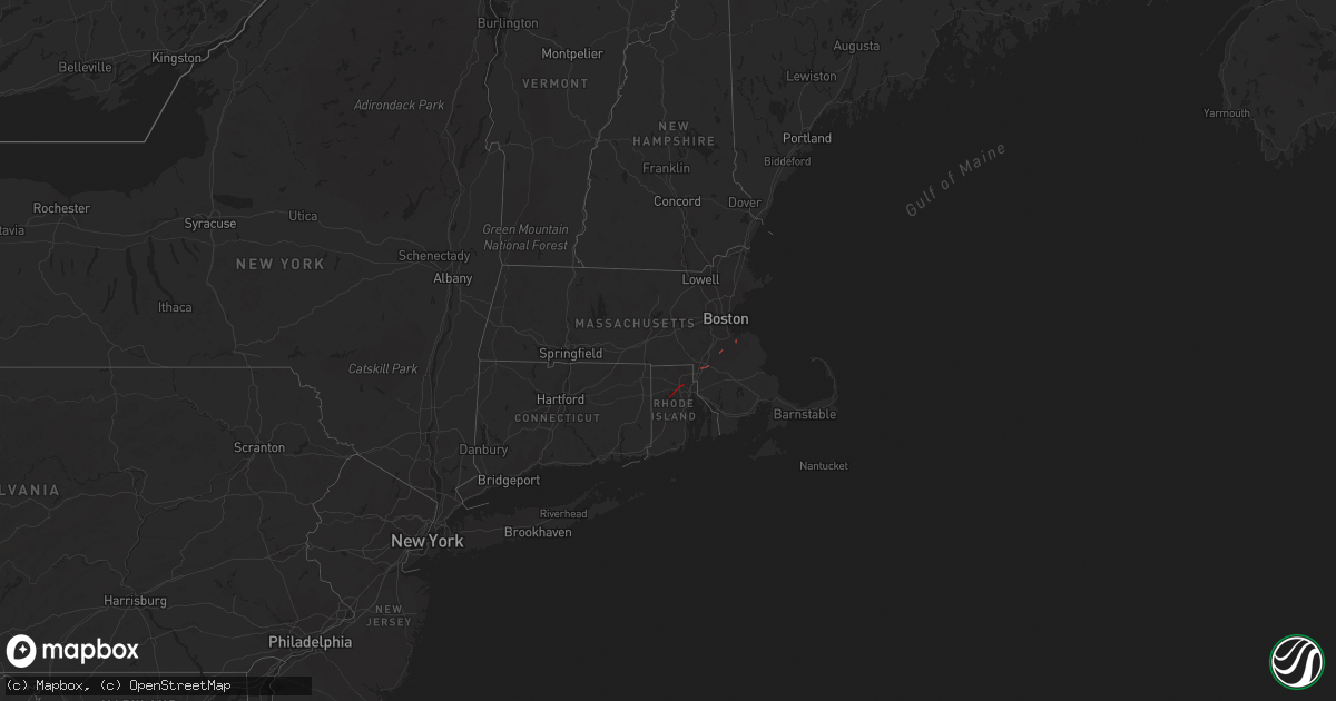
Hail Map in Rhode Island on August 18, 2023
Get this storm
August 18 map
$229
one time, instant access
Download today. No call, no setup
Keep the $229
Bought the map and want the full workflow? Apply the entire $229 to a subscription within 7 days. None of it is wasted.
Every map, not just this one
This buys you this map. Subscription and you get every map we run, in the markets you choose from a few cities to whole states to nationwide. Plus real-time alerts the moment a storm fires.
Contact data
Name, contact info, occupancy, even credit band for addresses in the footprint. You go from where it hit to who to call.
Become the source they trust
Unlimited branding weather history reports on demand. You already have the documented answer ready for the property owner, and you are the one who showed up with it.
Property data and RoofTrace estimates
Pull up any address you have got, its value and the exact code rules for that jurisdiction, straight from One Click Code. Then RoofTrace estimates the squares, pitch, and roof value, priced the way you price.
Storm reports in Rhode Island
Rhode Island
| Date | Description |
|---|---|
| 08/18/20238:10 AM CDT | Large tree and power lines down. |
| 08/18/20238:08 AM CDT | Multiple branches and a few large trees down. |
| 08/18/20238:08 AM CDT | Tree down on cars. |
| 08/18/20238:05 AM CDT | Tree and wires down. |
| 08/18/20237:51 AM CDT | Tree down on road. |
| 08/18/20237:50 AM CDT | Tree down on road. |
| 08/18/20237:45 AM CDT | Trees and branches down. |
| 08/18/20237:45 AM CDT | Broadcast media relayed a video of a tornado crossing i-295 on the smithfield and johnston town line. Time estimated to be 8:45 am. |
| 08/18/20237:40 AM CDT | Multiple trees and wires down. |
| 08/18/20237:40 AM CDT | Tree down on a house. |
| 08/18/20237:40 AM CDT | Numerous trees down on byron randall road. Additionally... A tree down on a home at the 200 block. |
| 08/18/20237:39 AM CDT | Large branches down on roadway. |
| 08/18/20237:34 AM CDT | Tree down on town farm road. |
All States Impacted by Hail Map on August 18, 2023
Cities Impacted by Hail Map on August 18, 2023
- Johnston, RI
- North Providence, RI
- Providence, RI
- North Scituate, RI
- Limon, CO
- Sells, AZ
- Lithia, FL
- Orlando, FL
- Oviedo, FL
- Okeechobee, FL
- Nogales, AZ
- Patagonia, AZ
- Oshkosh, NE
- Junction City, CA
- Big Bar, CA
- Ocotillo, CA
- Lewellen, NE
- Conifer, CO
- Wellington, UT
- Nevada City, CA
- Grass Valley, CA
- Needles, CA
- Price, UT
- Chappell, NE
- Pine, CO
- Saint Johns, AZ
- Quemado, NM
- South Weymouth, MA
- Weymouth, MA
- Stoughton, MA
- North Attleboro, MA
- Mansfield, MA
- Tucson, AZ
- Amado, AZ
- Rio Rico, AZ
- Tumacacori, AZ
- Tubac, AZ
- Helena, MT
- Avon, MT
- Fort Harrison, MT
- Townsend, MT
- Jefferson City, MT
- East Helena, MT
- Clancy, MT
- Winston, MT
- Boulder, MT
- Toston, MT
- Stanford, MT
- Emigrant, MT
- Gardiner, MT
- Livingston, MT
- Pray, MT
- Absarokee, MT
- Big Timber, MT
- McLeod, MT
- Nye, MT
- Fishtail, MT
- Springdale, MT
- Columbus, MT
- Greycliff, MT
- Reed Point, MT
- Bridger, MT
- Park City, MT
- Joliet, MT
- Laurel, MT
- Billings, MT
- Molt, MT
- Jordan, MT
- Circle, MT
- Fort Peck, MT
- Wolf Point, MT
- Richey, MT
- Poplar, MT
- Vida, MT
- Lambert, MT
- Bloomfield, MT
- Sidney, MT
- Brockton, MT
- Trenton, ND
- Cartwright, ND
- Williston, ND
- Culbertson, MT
- Fairview, MT
- Bainville, MT


