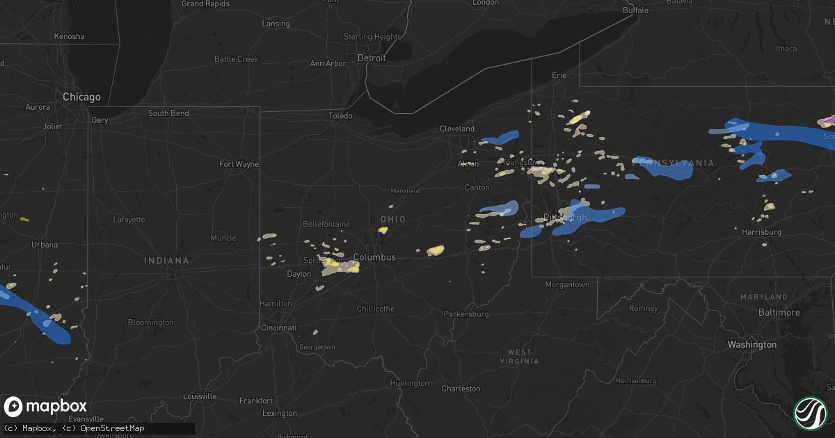
Hail Map in Ohio on August 12, 2021
Get this storm
August 12 map
$229
one time, instant access
Download today. No call, no setup
Keep the $229
Bought the map and want the full workflow? Apply the entire $229 to a subscription within 7 days. None of it is wasted.
Every map, not just this one
This buys you this map. Subscription and you get every map we run, in the markets you choose from a few cities to whole states to nationwide. Plus real-time alerts the moment a storm fires.
Contact data
Name, contact info, occupancy, even credit band for addresses in the footprint. You go from where it hit to who to call.
Become the source they trust
Unlimited branding weather history reports on demand. You already have the documented answer ready for the property owner, and you are the one who showed up with it.
Property data and RoofTrace estimates
Pull up any address you have got, its value and the exact code rules for that jurisdiction, straight from One Click Code. Then RoofTrace estimates the squares, pitch, and roof value, priced the way you price.
Storm reports in Ohio
Ohio
| Date | Description |
|---|---|
| 08/12/20216:50 PM CDT | Report of trees down and power outages. Time estimated based on radar. |
| 08/12/20216:45 PM CDT | Multiple large trees down. |
| 08/12/20216:41 PM CDT | Report of multiple trees down and widespread power outages. |
| 08/12/20216:36 PM CDT | Report of large tree down in yard. |
| 08/12/20216:14 PM CDT | Report of multiple trees down. |
| 08/12/20216:05 PM CDT | Photos show numerous large tree branches snapped. Time estimated based on radar. |
| 08/12/20215:54 PM CDT | Numerous trees down throughout city. |
| 08/12/20215:52 PM CDT | Report and photo of multiple trees down blocking 4th avenue. Time estimated based on radar. |
| 08/12/20215:52 PM CDT | Numerous trees down along croft street. Time estimated based on radar. |
| 08/12/20215:19 PM CDT | Multiple large tree limbs down on us 62. |
| 08/12/20215:13 PM CDT | A local report indicates 1.00 inch wind near 5 N MOUNT STERLING |
| 08/12/20215:13 PM CDT | Large tree down in roadway. |
| 08/12/20215:11 PM CDT | Photo of snapped trees in steubenville. Time estimated based on radar. |
| 08/12/20215:09 PM CDT | Large tree down. Fell into power lines. |
| 08/12/20215:07 PM CDT | Multiple large tree limbs downed in roadway. |
| 08/12/20215:05 PM CDT | Large tree down blocking roadway. |
| 08/12/20215:05 PM CDT | Multiple large trees down blocking roads. |
| 08/12/20215:02 PM CDT | Large tree down blocking roadway. |
| 08/12/20214:36 PM CDT | Per scanner... Tree down on house on euclid blvd. In boardman. Time estimated via radar. |
| 08/12/20214:18 PM CDT | Multiple trees down on wilson road. Time estimated using radar data. |
| 08/12/20214:11 PM CDT | Photo of snapped trees in steubenville. Time estimated based on radar. |
| 08/12/20214:09 PM CDT | *** 1 inj *** tree fell on a vehicle near the intersection of springvalley road and state route 665 leading to one injury. Time estimated using radar data. |
| 08/12/20213:49 PM CDT | Tree down on wires. |
| 08/12/20213:44 PM CDT | Tree fell onto backyard pool. |
| 08/12/20213:20 PM CDT | Tree down at lewis ave. And lincoln ave. In maplewood park. Time estimated via radar. |
| 08/12/20213:19 PM CDT | Trees down at clark state. Time estimated from radar. |
| 08/12/20213:14 PM CDT | Large limb down. |
| 08/12/20213:13 PM CDT | A local report indicates 1.00 inch wind near 5 NW LONDON |
| 08/12/20213:11 PM CDT | Tree down on garage. |
| 08/12/20213:09 PM CDT | Trees down in holiday hills. Time estimated from radar. |
| 08/12/20212:57 PM CDT | Several large limbs down and 8 inch diameter trees snapped off. |
| 08/12/20212:51 PM CDT | Tree down. Time estimated from radar. |
| 08/12/202110:00 AM CDT | Several trees down. |
| 08/12/20219:38 AM CDT | Tree down on wires. |
| 08/12/20219:32 AM CDT | Large branch and utility wires down. |
| 08/12/20216:51 AM CDT | At 1151 PM EDT, a severe thunderstorm was located near Sunbury, moving northeast at 25 mph. HAZARD...Quarter size hail. SOURCE...Radar indicated. IMPACT...Minor damage to vehicles is possible. Locations impacted include... Sunbury and Olive Green. This includes I-71 in Ohio between mile markers 132 and 138. |
| 08/12/20216:51 AM CDT | At 1150 PM EDT, a severe thunderstorm was located near Centerburg, or 15 miles south of Mount Gilead, moving east at 30 mph. HAZARD...60 mph wind gusts and quarter size hail. SOURCE...Radar indicated. IMPACT...Minor damage to vehicles is possible. Expect damage to trees and power lines. Locations impacted include... Mount Vernon, Fredericktown, Gambier, Utica, Centerburg, Sparta, Marengo, Martinsburg, North Liberty and Bladensburg. |
| 08/12/20216:33 AM CDT | At 1133 AM EDT, a severe thunderstorm was located over Farrell, or over Sharon, moving east at 40 mph. HAZARD...60 mph wind gusts. SOURCE...Radar indicated. IMPACT...Expect damage to trees and power lines, resulting in some power outages. Locations impacted include... Hermitage, Sharon, Grove City, Sharpsville, Farrell, New Wilmington, Mercer, Pulaski, Stoneboro, New Bedford, West Middlesex, and Plain Grove Township. |
| 08/12/20215:28 AM CDT | At 1028 AM EDT, severe thunderstorms were located along a line extending from near Highland Hills to Solon to near Cuyahoga Falls, moving east at 45 mph. HAZARD...60 mph wind gusts. SOURCE...Radar indicated. IMPACT...Expect damage to trees and power lines. Locations impacted include... Chardon, Cleveland Heights, Solon, Hudson, Twinsburg, Streetsboro, Warrensville Heights, Macedonia, Cortland, South Russell, Middlefield, Garrettsville, North Bloomfield, Orwell, Burton, Highland Hills, Mantua, West Farmington, Chesterland and Bristolville. |
| 08/12/20214:00 AM CDT | At 900 PM EDT, a severe thunderstorm was located near Dennison, or near Uhrichsville, moving east at 20 mph. HAZARD...60 mph wind gusts. SOURCE...Radar indicated. IMPACT...Expect damage to trees and power lines, resulting in some power outages. Locations impacted include... Carrollton, Minerva, Dennison, Augusta, Salineville, Malvern, Mineral City, Bergholz, Amsterdam, Hanoverton, Bowerston, and Barnhill. |
| 08/12/20213:39 AM CDT | At 839 PM EDT, a severe thunderstorm was located near Wellsburg, moving northeast at 30 mph. HAZARD...60 mph wind gusts. SOURCE...Radar indicated. IMPACT...Expect damage to trees and power lines, resulting in some power outages. Locations impacted include... Weirton, Steubenville, Wellsburg, West Liberty, Avella, Robinson Township, Toronto, Wintersville, Mingo Junction, Follansbee, Midland, and Hooverson Heights. |
| 08/12/20212:46 AM CDT | At 745 PM EDT, a severe thunderstorm was located 8 miles south of Newcomerstown, or 9 miles north of Cambridge, moving east at 30 mph. HAZARD...60 mph wind gusts. SOURCE...Radar indicated. IMPACT...Expect damage to trees and power lines, resulting in some power outages. Locations impacted include... Cambridge, St. Clairsville, Cadiz, Freeport, Newcomerstown, Antrim, Flushing, Scio, Jewett, Holloway, New Athens, and Morristown. |
| 08/12/20212:44 AM CDT | At 744 PM EDT, a severe thunderstorm was located near West Milton, moving east at 30 mph. HAZARD...60 mph wind gusts and penny size hail. SOURCE...Radar indicated. IMPACT...Expect damage to trees and power lines. Locations impacted include... Troy, Tipp City, West Milton, Brown, Union, Casstown, Ludlow Falls, Ginghamsburg, Haven View and Grayson.This includes I-75 in Ohio between mile markers 66 and 74. |
| 08/12/20211:58 AM CDT | At 657 PM EDT, a severe thunderstorm was located near Dresden, or 7 miles north of Zanesville, moving northeast at 20 mph. HAZARD...60 mph wind gusts. SOURCE...Radar indicated. IMPACT...Expect damage to trees and power lines, resulting in some power outages. Locations impacted include... Zanesville, Coshocton, Cambridge, New Concord, Byesville, North Zanesville, Dresden, Frazeysburg, Pleasant Grove, Conesville, Plainfield, and Norwich. |
| 08/12/20211:33 AM CDT | At 633 PM EDT, severe thunderstorms were located along a line extending from Moon Township to near Wellsburg, moving east at 35 mph. HAZARD...60 mph wind gusts. SOURCE...Radar indicated. IMPACT...Expect damage to trees and power lines, resulting in some power outages. Locations impacted include... Pittsburgh, Penn Hills, Mount Lebanon, Bethel Park, Ross Township, McCandless Township, Monroeville, Moon Township, McMurray, McKeesport, Washington, and Franklin Park. |
| 08/12/202112:28 AM CDT | At 528 PM EDT, a severe thunderstorm was located near Jefferson, moving east at 20 mph. HAZARD...60 mph wind gusts and quarter size hail. SOURCE...Radar indicated. IMPACT...Minor hail damage to vehicles is possible. Expect wind damage to trees and power lines. Locations impacted include... Columbus, Grove City, Bexley, Jefferson, West Jefferson, Lake Darby, Grandview Heights, Obetz, Urbancrest, Valleyview, Marble Cliff, Harrisburg, Orient, Lockbourne, Lilly Chapel, Georgesville, Madison Lake, Darbydale and Big Plain.This includes the following Interstates... I-70 in Ohio between mile markers 79 and 103. I-71 in Ohio between mile markers 86 and 109. |
| 08/12/202112:03 AM CDT | At 503 PM EDT, a severe thunderstorm was located near New Wilmington, or 7 miles north of New Castle, moving east at 35 mph. HAZARD...60 mph wind gusts. SOURCE...Radar indicated. IMPACT...Expect damage to trees and power lines, resulting in some power outages. Locations impacted include... New Castle, Hermitage, Grove City, Slippery Rock, New Wilmington, Oakwood, New Castle Northwest, Pulaski, Bessemer, New Bedford, Harrisville, and West Middlesex. |
| 08/11/202111:52 PM CDT | At 452 PM EDT, a severe thunderstorm was located near Ravenna, moving east at 20 mph. HAZARD...60 mph wind gusts and quarter size hail. SOURCE...Radar indicated. IMPACT...Minor damage to vehicles is possible. Expect damage to trees and power lines. Locations impacted include... Youngstown, Ravenna, Boardman, Campbell, Canfield, Sebring, Austintown, Struthers, Brimfield, Randolph, Atwater, Edinburg, Poland, Ellsworth, New Middletown, Craig Beach, Lowellville, Deerfield, North Jackson and Berlin Center. |
| 08/11/202111:41 PM CDT | At 440 PM EDT, a severe thunderstorm was located 3 miles southeast of Springfield, moving east at 15 mph. HAZARD...60 mph wind gusts and quarter size hail. SOURCE...Radar indicated. IMPACT...Minor hail damage to vehicles is possible. Expect wind damage to trees and power lines. Locations impacted include... Springfield, South Charleston, Choctaw Lake, Harmony, Lisbon, Brighton, South Vienna, Clifton, Pitchin, Springfield Municipal Airport and Plattsburg.This includes I-70 in Ohio between mile markers 53 and 73. |
| 08/11/202111:27 PM CDT | At 427 PM EDT, a severe thunderstorm was located over Garrettsville, or 12 miles northeast of Ravenna, moving east at 40 mph. HAZARD...60 mph wind gusts and quarter size hail. SOURCE...Radar indicated. IMPACT...Minor damage to vehicles is possible. Expect damage to trees and power lines. Locations impacted include... Warren, Ravenna, Cuyahoga Falls, Kent, Hudson, Niles, Twinsburg, Streetsboro, Hubbard, Cortland, Newton Falls, Lordstown, Garrettsville, Mantua, West Farmington, Vienna Center, Hilltop, Maplewood Park, Bristolville and Leavittsburg. |
| 08/11/202111:09 PM CDT | At 409 PM EDT, a severe thunderstorm was located over Akron, moving east at 20 mph. HAZARD...60 mph wind gusts and quarter size hail. SOURCE...Radar indicated. IMPACT...Minor damage to vehicles is possible. Expect damage to trees and power lines. Locations impacted include... Akron, Ravenna, Cuyahoga Falls, Kent, Barberton, Tallmadge, Mogadore, Stow, Norton, Brimfield, Fairlawn, Randolph, Munroe Falls, Lakemore, Atwater, Edinburg, Silver Lake, Brady Lake, Portage Lakes and Montrose-Ghent. |
| 08/11/202111:03 PM CDT | At 403 PM EDT, a severe thunderstorm was located near Springfield, moving east at 25 mph. HAZARD...60 mph wind gusts and penny size hail. SOURCE...Radar indicated. IMPACT...Expect damage to trees and power lines. Locations impacted include... Springfield, London, Choctaw Lake, Harmony, Brighton, Lafayette, South Vienna, Catawba, Buck Creek State Park, State Route 29 at State Route 38, Interstate 70 at State Route 56, New Moorefield and Plattsburg.This includes I-70 in Ohio between mile markers 56 and 78. |
| 08/11/202110:58 PM CDT | Several trees down. Lightning struck a house. Time estimated from radar. |
| 08/11/202110:42 PM CDT | At 342 PM EDT, a severe thunderstorm was located near Macedonia, or 12 miles north of Akron, moving east at 20 mph. HAZARD...60 mph wind gusts and quarter size hail. SOURCE...Radar indicated. IMPACT...Minor damage to vehicles is possible. Expect damage to trees and power lines. Locations impacted include... Ravenna, Cuyahoga Falls, Kent, Hudson, Twinsburg, Streetsboro, Macedonia, Garrettsville, Mantua, Stow, Aurora, Brecksville, Richfield, Reminderville, Silver Lake, Windham, Hiram, Boston Heights, Peninsula and Brady Lake. |
| 08/11/20218:05 PM CDT | Multiple trees down between sherrodsville and leesville |
| 08/11/20217:39 PM CDT | County reported several trees and power lines down in the area |
All States Impacted by Hail Map on August 12, 2021
Cities Impacted by Hail Map on August 12, 2021
- Orient, OH
- Mount Sterling, OH
- Grove City, OH
- London, OH
- Galloway, OH
- South Solon, OH
- Cedarville, OH
- Yellow Springs, OH
- West Jefferson, OH
- South Charleston, OH
- South Vienna, OH
- Springfield, OH
- Munden, KS
- Sullivan, IN
- Merom, IN
- Edinburg, PA
- New Castle, PA
- Hillsville, PA
- Morrisonville, IL
- Overland Park, KS
- Pittsburgh, PA
- Shawnee, KS
- Oakdale, IL
- Coulterville, IL
- Syracuse, KS
- Leavenworth, KS
- Norfolk, CT
- Holdrege, NE
- Kansas City, MO
- Hoyt, KS
- Topeka, KS
- Oblong, IL
- Annapolis, IL
- Martinsville, IL
- Limon, CO
- Sterling, KS
- Hutchinson, KS
- Nickerson, KS
- Raymond, KS
- Chase, KS
- Lyons, KS
- Sabetha, KS
- Bern, KS
- Oskaloosa, KS
- East Lynne, MO
- Garden City, MO
- Harrisonville, MO
- Ayr, NE
- Lawrence, NE
- Blue Hill, NE
- Linwood, KS
- De Soto, KS
- Harvel, IL
- Liverpool, IL
- Canton, IL
- Polo, MO
- Lawson, MO
- Shoals, IN
- Tampa, KS
- Springfield, IL
- Nashport, OH
- Zanesville, OH
- Feeding Hills, MA
- West Suffield, CT
- Suffield, CT
- Southwick, MA
- Clarion, PA
- Sligo, PA
- Saint Louis, MO
- Mittie, LA
- Jermyn, PA
- Carbondale, PA
- Factoryville, PA
- Nicholson, PA
- Fleetville, PA
- Dalton, PA
- Tunkhannock, PA
- Ness City, KS
- West Jefferson, NC
- Millers Creek, NC
- Purlear, NC
- Portersville, PA
- Slippery Rock, PA
- Pulaski, PA
- Moweaqua, IL
- Assumption, IL
- Bethany, IL
- Wallace, KS
- Sharon Springs, KS
- Weskan, KS
- Lucas, KS
- Sylvan Grove, KS
- Selden, KS
- Browning, IL
- Hamilton, MO
- Winston, MO
- Gallatin, MO
- Kidder, MO
- Elsberry, MO
- Silex, MO
- Clarksville, MO
- Eolia, MO
- Bowling Green, MO
- Colby, KS
- Levant, KS
- Winona, KS
- Monument, KS
- Arapahoe, NE
- Oxford, NE
- Edison, NE
- Swanton, NE
- Western, NE
- Hillsboro, KS
- Lehigh, KS
- Newton, KS
- Goessel, KS
- Hoxie, KS
- Rexford, KS
- Union City, OH
- Union City, IN
- Montgomery City, MO
- New Florence, MO
- Dighton, KS
- Wilcox, NE
- Stockton, KS
- Emporia, KS
- Morris, PA
- Concordia, KS
- Jamestown, KS
- Hydetown, PA
- Centerville, PA
- Guys Mills, PA
- Cooperstown, PA
- Titusville, PA
- Grand Valley, PA
- Indianola, NE
- Bartley, NE
- Cambridge, NE
- Vona, CO
- McDonald, PA
- Burgettstown, PA
- Bulger, PA
- Morrowville, KS
- Linn, KS
- Norborne, MO
- Lexington, MO
- Axtell, KS
- Baileyville, KS
- Amsterdam, OH
- Powhattan, KS
- Netawaka, KS
- Wetmore, KS
- Tallmadge, OH
- Akron, OH
- Peyton, CO
- Ansonia, OH
- Scott City, KS
- Marienthal, KS
- Corning, KS
- Centralia, KS
- Seneca, KS
- Montverde, FL
- Clermont, FL
- Clemmons, NC
- Wathena, KS
- Mayview, MO
- Wellington, MO
- Odessa, MO
- Overton, NV
- Home, KS
- Grainfield, KS
- Grinnell, KS
- Oakley, KS
- Dolan Springs, AZ
- Bonner Springs, KS
- Basehor, KS
- Sturgeon, PA
- Steinauer, NE
- Burchard, NE
- Pawnee City, NE
- Lawrence, KS
- Moundridge, KS
- Hesston, KS
- Meadows Of Dan, VA
- Stuart, VA
- Floyd, VA
- Willis, VA
- Lebanon, TN
- Hartsville, TN
- Riddleton, TN
- Hurtsboro, AL
- Auburn, NE
- Dawson, NE
- Verdon, NE
- Stella, NE
- Shubert, NE
- Texline, TX
- Cameron, MO
- Pawnee, IL
- Poseyville, IN
- Tulia, TX
- Barnesville, OH
- Sherrodsville, OH
- Bowerston, OH
- Dennison, OH
- Adams, NE
- Pickrell, NE
- Cortland, NE
- Firth, NE
- Bedford, IN
- Heltonville, IN
- Norman, IN
- Minneola, KS
- Greenville, MO
- Hildebran, NC
- Connelly Springs, NC
- Hickory, NC
- Sibley, MO
- Oak Grove, MO
- Napoleon, MO
- Grain Valley, MO
- Blue Springs, MO
- Jefferson, NC
- Milton, PA
- Northumberland, PA
- Craig, MO
- Ellsworth, KS
- Kanopolis, KS
- Peculiar, MO
- Waldo, KS
- Paradise, KS
- Stanford, IL
- Minier, IL
- Cheyenne Wells, CO
- Lincoln, KS
- Forest City, PA
- Union Dale, PA
- Waymart, PA
- Waterville, KS
- Barnes, KS
- Natoma, KS
- Victoria, KS
- Gorham, KS
- Walnut, MS
- Worthville, KY
- Owenton, KY
- Berryton, KS
- Hays, KS
- Lorraine, KS
- Goff, KS
- Horton, KS
- Montrose, IA
- Keokuk, IA
- Adamsville, OH
- Hopewell, OH
- Frazeysburg, OH
- Dresden, OH
- Marquette, KS
- Little River, KS
- Cochranton, PA
- West Mifflin, PA
- Homestead, PA
- Braddock, PA
- Lecompton, KS
- Quinter, KS
- Holly, CO
- Albany, NY
- Guilderland, NY
- Schenectady, NY
- Abilene, KS
- Argyle, IA
- Kahoka, MO
- Wayland, MO
- Silverton, TX
- Soldier, KS
- Havensville, KS
- Plainville, KS
- Mooresville, MO
- Breckenridge, MO
- Russell, KS
- Bunker Hill, KS
- Lansing, NC
- Warrensville, NC
- Jamesport, MO
- Augusta, KS
- Summerville, PA
- Strattanville, PA
- Marysville, OH
- Palmer, IL
- Owaneco, IL
- Taylorville, IL
- Kampsville, IL
- Hamburg, IL
- Winfield, MO
- Foley, MO
- Nebo, IL
- Troy, MO
- Moscow Mills, MO
- Annada, MO
- Hutsonville, IL
- Robinson, IL
- Ellis, KS
- Boulder City, NV
- Barnard, KS
- Lewisberry, PA
- Dover, PA
- York Haven, PA
- Abernathy, TX
- Anton, TX
- Littlefield, TX
- Pomona, KS
- Greenup, IL
- Casey, IL
- Concordia, MO
- Whitewater, KS
- Burns, KS
- Potwin, KS
- Karval, CO
- Hugo, CO
- Ferrum, VA
- Axtell, NE
- Hildreth, NE
- Cowgill, MO
- Richmond, MO
- Falls City, NE
- Woodston, KS
- Olathe, KS
- Sarasota, FL
- Trinidad, CO
- Matheson, CO
- Bucyrus, KS
- Freeport, OH
- Kimbolton, OH
- Du Bois, NE
- Excelsior Springs, MO
- Corder, MO
- Seligman, AZ
- Holton, KS
- Effingham, KS
- Muscotah, KS
- Valley Falls, KS
- Ransom, KS
- Sheridan Lake, CO
- Fairview, KS
- Cogan Station, PA
- Eudora, KS
- Quenemo, KS
- Ottawa, KS
- Vassar, KS
- Overbrook, KS
- Weston, MO
- Platte City, MO
- Portis, KS
- New Philadelphia, PA
- Brockton, PA
- Lakin, KS
- Kendall, KS
- Marquand, MO
- Bergholz, OH
- Gardner, KS
- Emlenton, PA
- Kennerdell, PA
- Stockport, IA
- Smith Center, KS
- Braymer, MO
- Dawn, MO
- Senoia, GA
- Plymouth, NE
- Collyer, KS
- Ogallah, KS
- Wakeeney, KS
- Arapahoe, CO
- Leoti, KS
- Iola, TX
- Tonganoxie, KS
- Franklin, PA
- Nortonville, KS
- Ferguson, NC
- Wilkesboro, NC
- Lawrenceville, IL
- Union Springs, AL
- Parrish, FL
- Manito, IL
- Topeka, IL
- Forest City, IL
- Havana, IL
- Luray, KS
- Evans City, PA
- Prospect, PA
- Harmony, PA
- Renfrew, PA
- Butler, PA
- West Sunbury, PA
- Highland, IL
- Oil City, PA
- Milford Center, OH
- Whiting, KS
- Durham, KS
- Andover, OH
- Mayport, PA
- Coolspring, PA
- Brookville, PA
- Sprankle Mills, PA
- Punxsutawney, PA
- Morrill, KS
- Hiawatha, KS
- Deer Trail, CO
- Canaan, CT
- East Canaan, CT
- Tecumseh, NE
- Johnson, NE
- Elk Creek, NE
- Alma, MO
- Blackburn, MO
- Healy, KS
- Ariton, AL
- De Witt, NE
- Clatonia, NE
- Oregon, MO
- Wilber, NE
- Daykin, NE
- Fenton, MO
- Osborne, KS
- Onaga, KS
- Pleasant Hill, MO
- Atchison, KS
- Cummings, KS
- Ohiowa, NE
- Strang, NE
- Bradford, IL
- Putnam, IL
- Kansas City, KS
- Hamilton, KS
- Marshall, IL
- Mcpherson, KS
- Galva, KS
- Lithonia, GA
- Natchitoches, LA
- Natchez, LA
- Robeline, LA
- McCook, NE
- Winchester, IN
- Flagler, CO
- Castleton On Hudson, NY
- Selkirk, NY
- Glenmont, NY
- Warren, OH
- Mineral Ridge, OH
- Niles, OH
- Gypsum, KS
- Ramer, AL
- Montgomery, AL
- De Kalb, MO
- Grenola, KS
- Howard, KS
- Altamont, MO
- Smithville, MO
- Lees Summit, MO
- Buckner, MO
- Independence, MO
- Genoa, CO
- Sherman, IL
- Trout Run, PA
- Kit Carson, CO
- Vincennes, IN
- Sunbury, OH
- Centerburg, OH
- Sullivan, IL
- Versailles, OH
- Lutz, FL
- Tampa, FL
- Odessa, FL
- Vermillion, KS
- Summerfield, KS
- Dearborn, MO
- Olney, IL
- Robinson, KS
- Everest, KS
- Hamel, IL
- Edwardsville, IL
- Worden, IL
- Table Rock, NE
- Troy, KS
- Medora, IL
- Hackberry, AZ
- Roseland, NE
- Glenvil, NE
- Bladen, NE
- Deerfield, OH
- Mercer, MO
- Sainte Genevieve, MO
- Conover, OH
- Fletcher, OH
- Saint Paris, OH
- Jonesburg, MO
- Eureka, KS
- Virgil, KS
- Saint Petersburg, FL
- Lewistown, IL
- Tescott, KS
- Beverly, KS
- Agate, CO
- Hays, NC
- McGrady, NC
- Carthage, TN
- Gaylord, KS
- Winsted, CT
- Pontiac, IL
- Flanagan, IL
- Virden, IL
- Piedmont, KS
- Latham, KS
- Belleville, KS
- Brookville, OH
- Salina, KS
- Williams, AZ
- Frankfort, KS
- Reading, KS
- Pinnacle, NC
- Westfield, NC
- Pilot Mountain, NC
- Cantrall, IL
- Stratton, CO
- Knox, PA
- Shippenville, PA
- Piper City, IL
- Humboldt, NE
- Girard, IL
- Pendleton, KY
- La Grange, KY
- Walton, KS
- Canton, KS
- Peabody, KS
- Dumas, TX
- Clifton Park, NY
- Rexford, NY
- Warrenton, MO
- Edinburg, IL
- Kincaid, IL
- Mound City, MO
- Bolckow, MO
- White Cloud, KS
- Rulo, NE
- Maitland, MO
- Savannah, MO
- Bendena, KS
- Lancaster, KS
- Amazonia, MO
- Nemaha, NE
- Highland, KS
- Denton, KS
- Fillmore, MO
- Forest City, MO
- Potosi, MO
- Belgrade, MO
- Lenexa, KS
- Linden, PA
- Saint Joseph, MO
- Faucett, MO
- Agency, MO
- Laurel, IN
- Greensburg, IN
- Moores Hill, IN
- Milan, IN
- Quitaque, TX
- North Benton, OH
- Beloit, OH
- Berlin Center, OH
- Coventry, CT
- Storrs Mansfield, CT
- Tolland, CT
- Willington, CT
- Meadville, PA
- Beloit, KS
- Columbia, IL
- Burrton, KS
- Halstead, KS
- Buhler, KS
- Lawsonville, NC
- Old Town, FL
- Esbon, KS
- Lebanon, KS
- Madison, KS
- Olpe, KS
- Chillicothe, MO
- Freeburg, IL
- Quaker City, OH
- Lagrange, GA
- Linesville, PA
- Muncy Valley, PA
- Hettick, IL
- Greenfield, IL
- Wauchula, FL
- Simla, CO
- Oberlin, KS
- Bruning, NE
- Lykens, PA
- Wiconisco, PA
- Liberty, NE
- Dillonvale, OH
- Adena, OH
- Cadiz, OH
- Heath, OH
- Madison, FL
- Palmetto, FL
- Ellenton, FL
- Herndon, PA
- Bath, IL
- Greenville, OH
- Medora, IN
- Rochester, IL
- Chatham, IL
- Bradenton, FL
- Rhineland, MO
- Oakmont, PA
- Cheswick, PA
- Leechburg, PA
- Apollo, PA
- Tarentum, PA
- Natrona Heights, PA
- Creighton, PA
- Verona, PA
- Brackenridge, PA
- Vandergrift, PA
- Glenshaw, PA
- Freeport, PA
- Indianola, PA
- Allison Park, PA
- Harwick, PA
- Springdale, PA
- New Kensington, PA
- Spring Glen, PA
- Gratz, PA
- Halifax, PA
- Elizabethville, PA
- Bushnell, IL
- Marietta, IL
- Torrington, CT
- Falls Village, CT
- Salem, NE
- Newton Falls, OH
- Garrettsville, OH
- Southington, OH
- Windham, OH
- Adrian, MO
- Archie, MO
- Weatherby, MO
- Wellsville, KS
- Baldwin City, KS
- Alexandria, NE
- Peninsula, OH
- Alhambra, IL
- Jersey Shore, PA
- Newcomerstown, OH
- Port Washington, OH
- Lansing, KS
- Marissa, IL
- Addieville, IL
- Mascoutah, IL
- Fenelton, PA
- Tobias, NE
- Athens, IL
- Riverton, IL
- Perry, KS
- Conroe, TX
- Brookville, IN
- Metamora, IN
- Connersville, IN
- Albert, KS
- Rushville, MO
- Marion, KS
- Rensselaer, NY
- Danvers, IL
- Bates City, MO
- Allerton, IA
- Hardin, MO
- Danbury, NE
- Paris, IL
- Houston, TX
- Stilwell, KS
- Grandview, MO
- Dover, MO
- Orrick, MO
- Lone Jack, MO
- Henrietta, MO
- Levasy, MO
- New Century, KS
- Higginsville, MO
- Waverly, MO
- Raymore, MO
- McLouth, KS
- Mission, KS
- Belton, MO
- Carrollton, MO
- Camden, MO
- Leawood, KS
- Cuba, IL
- Smithfield, IL
- Burdick, KS
- Dalmatia, PA
- Pillow, PA
- Batchtown, IL
- Donnellson, IA
- Farmington, IA
- Fredericktown, OH
- Mount Gilead, OH
- Carbon, IN
- Rosedale, IN
- Fredericktown, MO
- Falls Creek, PA
- Rockton, PA
- Reynoldsville, PA
- Du Bois, PA
- Geneva, NE
- Turners Station, KY
- Lexington, NC
- Norridgewock, ME
- Madison, ME
- Anson, ME
- French Lick, IN
- West Baden Springs, IN
- Spring Hill, KS
- Paola, KS
- Louisburg, KS
- Danville, PA
- Lenoxville, PA
- Falls, PA
- Olyphant, PA
- Edgerton, MO
- Bicknell, IN
- Hanover, KS
- Admire, KS
- West Middlesex, PA
- Hubbard, OH
- Pana, IL
- Shelbyville, IL
- Ironton, MO
- Annapolis, MO
- Callaway, VA
- Bristol, FL
- Fort Leavenworth, KS
- Hoxie, AR
- Walnut Ridge, AR
- Portia, AR
- Deweese, NE
- Fairfield, NE
- Lovington, IL
- Midway, AL
- Jonesville, KY
- Glencoe, KY
- Dry Ridge, KY
- Blountstown, FL
- Hope, KS
- Townville, PA
- Mantua, OH
- Chagrin Falls, OH
- Aurora, OH
- North Jackson, OH
- Blairsville, PA
- Youngstown, OH
- Lowellville, OH
- Gnadenhutten, OH
- Uhrichsville, OH
- Park, KS
- Kingston, MO
- Luray, MO
- Mount Sterling, IA
- Bonaparte, IA
- Liberal, MO
- Modesto, IL
- Waverly, IL
- New Liberty, KY
- Milligan, NE
- McCracken, KS
- Belleville, IL
- East Saint Louis, IL
- Granada, CO
- Henry, IL
- Denison, KS
- Landisburg, PA
- Shermans Dale, PA
- Bowling Green, IN
- Florissant, MO
- Mcconnelsville, OH
- Mascotte, FL
- Howey In The Hills, FL
- Groveland, FL
- Winfield, PA
- Lewisburg, PA
- Pella, IA
- Otley, IA
- Youngstown, FL
- Vernon, FL
- Panama City, FL
- Pattonsburg, MO
- Bethany, MO
- McFall, MO
- Leon, KS
- Holyrood, KS
- Carlisle, IN
- Gordonsville, TN
- Spickard, MO
- Washington, KS
- Haddam, KS
- Avonmore, PA
- Spring Church, PA
- Shelocta, PA
- Astoria, IL
- East Carondelet, IL
- Dupo, IL
- Thonotosassa, FL
- Duncannon, PA
- Volant, PA
- Joffre, PA
- Oakdale, PA
- Edgewood, IL
- Dalhart, TX
- Union City, PA
- Marysville, KS
- Leitchfield, KY
- Lock Haven, PA
- Cammal, PA
- Waterville, PA
- Chrisman, IL
- Lewis, IN
- Shelburn, IN
- Downs, KS
- Climax Springs, MO
- Roach, MO
- Claudville, VA
- Ringgold, VA
- Ipava, IL
- Table Grove, IL
- Carrollton, OH
- Alton, KS
- Alliance, OH
- Salem, OH
- Canfield, OH
- Sebring, OH
- Flushing, OH
- Saint Clairsville, OH
- Green, KS
- Randolph, KS
- Newton, IL
- Matfield Green, KS
- Americus, KS
- Vienna, OH
- Grove City, PA
- Brussels, IL
- Saint Charles, MO
- Portage Des Sioux, MO
- Campbell, NE
- Hermann, MO
- Wenona, IL
- Ancona, IL
- Long Point, IL
- Dana, IL
- Mechanicsburg, OH
- Catawba, OH
- Fowler, KS
- Lesterville, MO
- New Port Richey, FL
- Holiday, FL
- Keosauqua, IA
- Revere, MO
- Blue Rapids, KS
- Yadkinville, NC
- Wilmington, OH
- Xenia, OH
- Jamestown, OH
- Deep Gap, NC
- Statesville, NC
- Easton, IL
- Lewisburg, OH
- West Manchester, OH
- Monongahela, PA
- Charleroi, PA
- Woodrow, CO
- Riverside, MO
- Mitchell, IN
- Tunnelton, IN
- Winston Salem, NC
- Galt, MO
- Madisonville, TX
- Louisville, KY
- Spring Hill, FL
- Dawson, IL
- Clifton, KS
- Oakland, IL
- Hindsboro, IL
- Schodack Landing, NY
- Sunbury, PA
- Jewett, OH
- Woolwine, VA
- Salesville, OH
- Winchester, KS
- Danbury, NC
- Shallowater, TX
- Williamsport, PA
- Finleyville, PA
- Amelia, OH
- Mingo Junction, OH
- Follansbee, WV
- Steubenville, OH
- Colliers, WV
- Hidalgo, IL
- Arcanum, OH
- New Madison, OH
- Hilliards, PA
- Boyers, PA
- Harrisville, PA
- Cabot, PA
- Sarver, PA
- Brownstown, IN
- Parker, PA
- Pekin, IL
- Macomb, IL
- Industry, IL
- Bryant, IL
- Adair, IL
- Saint David, IL
- Glasford, IL
- Pinellas Park, FL
- Carrollton, IL
- New Wilmington, PA
- Rayville, MO
- New Philadelphia, OH
- Trenton, MO
- Humphreys, MO
- Lickingville, PA
- Tionesta, PA
- Fryburg, PA
- Dallas City, IL
- Jacksonville, IL
- Minneapolis, KS
- Glasco, KS
- Delphos, KS
- Presto, PA
- Bridgeville, PA
- Carnegie, PA
- Kilbourne, IL
- Goodview, VA
- Vinton, VA
- Chula, MO
- Neoga, IL
- Delmar, NY
- Springboro, PA
- Conneautville, PA
- Circleville, KS
- Dubois, IN
- Goodwell, OK
- Utica, PA
- Carlton, PA
- Murrayville, IL
- Franklin, IL
- Happy, TX
- Colorado Springs, CO
- Wright City, MO
- Chino Valley, AZ
- Stewartsville, MO
- Osborn, MO
- Findlay, IL
- Salem, VA
- Woodlawn, VA
- Seminole, PA
- New Bethlehem, PA
- Maysville, MO
- Kane, IL
- Nevada, MO
- Piedmont, OH
- Camden Point, MO
- Hudson, OH
- Streetsboro, OH
- Bucklin, KS
- Rocky Mount, VA
- Lyons, IN
- Sandborn, IN
- Coeymans, NY
- Slingerlands, NY
- Ravena, NY
- Bushton, KS
- Ellinwood, KS
- Nashville, IN
- Advance, NC
- Brundidge, AL
- Spring Mills, PA
- Prairie Village, KS
- Crittenden, KY
- Edgar, NE
- Ong, NE
- Thurmond, NC
- Dobson, NC
- Gove, KS
- Mullinville, KS
- Potts Camp, MS
- Melvern, KS
- Lyndon, KS
- Easton, KS
- Utica, KS
- Freeman, MO
- Lincolnville, KS
- Kinsley, KS
- Urbana, OH
- Hardy, VA
- Conyers, GA
- Chicora, PA
- East Brady, PA
- Worthington, PA
- Jamestown, TN
- Catharine, KS
- Mount Orab, OH
- Frankfort, KY
- Bruceville, IN
- Karns City, PA
- Perryopolis, PA
- Grindstone, PA
- Oketo, KS
- Tribune, KS
- Gay, GA
- Concord, GA
- Pierpont, OH
- Butler, MO
- Normangee, TX
- Holstein, NE
- Stamford, NE
- Tilden, IL
- Sparta, IL
- Floyd, NM
- Scranton, KS
- Carbondale, KS
- Troy, AL
- Corsica, PA
- Newman, IL
- Greenwood, MO
- Hallam, NE
- Ludlow, MO
- Myrtle, MS
- New Albany, MS
- Princeton, MO
- Gilman City, MO
- Glen Elder, KS
- Pittsburg, KS
- Cypress, TX
- Conchas Dam, NM
- Dauphin, PA
- Tecumseh, KS
- Grantville, KS
- Cherokee, AL
- Gower, MO
- Alma, NE
- Ellington, MO
- Paxinos, PA
- Farmersville, IL
- Lake Milton, OH
- Diamond, OH
- Brownstown, IL
- Edgerton, KS
- Toledo, IL
- Bostic, NC
- Lewisville, OH
- Mason City, IL
- San Jose, IL
- Port Saint Joe, FL
- Jetmore, KS
- Cimarron, KS
- Pleasantville, PA
- Cleveland, MO
- Creighton, MO
- Abbeville, MS
- Oxford, MS
- Pottsville, PA
- Saint Clair, PA
- Lock Springs, MO
- Wheeling, MO
- Silva, MO
- Hogansville, GA
- Wampum, PA
- Ellwood City, PA
- West Pittsburg, PA
- New Galilee, PA
- Enon Valley, PA
- New Middletown, OH
- Bessemer, PA
- Leesville, OH
- Salineville, OH
- Scio, OH
- Canyon, TX
- Ona, FL
- McKees Rocks, PA
- Enterprise, KS
- North Lewisburg, OH
- Woodstock, OH
- Cable, OH
- Normal, IL
- Bloomington, IL
- Camargo, IL
- Fombell, PA
- Fort Montgomery, NY
- Timblin, PA
- Guilford, MO
- Linton, IN
- Jasonville, IN
- Lamar, CO
- Hunter, KS
- Vandalia, MO
- Maryland Heights, MO
- Curryville, MO
- Clarence, MO
- Shelbina, MO
- Bartelso, IL
- Crystal City, MO
- Stoutsville, MO
- Frankford, MO
- New Canton, IL
- Wellsville, MO
- Bellflower, MO
- Santa Fe, MO
- House Springs, MO
- Percy, IL
- Trenton, IL
- Campbell Hill, IL
- Red Bud, IL
- Albers, IL
- Martinsburg, MO
- Ashley, IL
- Rockport, IL
- Lentner, MO
- Richview, IL
- Eureka, MO
- Centralia, IL
- High Hill, MO
- O'Fallon, IL
- Saint Libory, IL
- Ashburn, MO
- Valmeyer, IL
- Walsh, IL
- High Ridge, MO
- Rush Hill, MO
- Ballwin, MO
- Golden Eagle, IL
- Chester, IL
- Saint Peters, MO
- Truxton, MO
- Holliday, MO
- Baldwin, IL
- Lebanon, IL
- Paris, MO
- Rockwood, IL
- Cutler, IL
- Summerfield, IL
- Saint Mary, MO
- Prairie Du Rocher, IL
- Perryville, MO
- Monroe City, MO
- Wildwood, MO
- Old Monroe, MO
- Festus, MO
- Saint Ann, MO
- Benton City, MO
- Pacific, MO
- Pevely, MO
- New Baden, IL
- Aviston, IL
- Laddonia, MO
- Bridgeton, MO
- Hull, IL
- Palmyra, MO
- Lake Saint Louis, MO
- Barnhart, MO
- Modoc, IL
- Ellis Grove, IL
- O'Fallon, MO
- Centralia, MO
- Perry, MO
- Hawk Point, MO
- Kinderhook, IL
- Valley Park, MO
- Millstadt, IL
- Hannibal, MO
- Scott Air Force Base, IL
- Arnold, MO
- Evansville, IL
- Breese, IL
- Bloomsdale, MO
- New London, MO
- Carlyle, IL
- Fults, IL
- Thompson, MO
- Foristell, MO
- Hecker, IL
- Middletown, MO
- Defiance, MO
- Mexico, MO
- Pleasant Hill, IL
- Madison, MO
- Okawville, IL
- Hoyleton, IL
- Herculaneum, MO
- Center, MO
- Nashville, IL
- Chesterfield, MO
- Farber, MO
- Pinckneyville, IL
- Lenzburg, IL
- Steeleville, IL
- Louisiana, MO
- New Athens, IL
- Smithton, IL
- Germantown, IL
- Hunnewell, MO
- Imperial, MO
- Waterloo, IL
- Wentzville, MO
- Liberty, MO
- Amsterdam, MO
- Amoret, MO
- La Cygne, KS
- Drexel, MO
- North Bloomfield, OH
- Hiram, OH
- West Farmington, OH
- Burton, OH
- Middlefield, OH
- Cortland, OH
- Bristolville, OH
- Mineral City, OH
- Dellroy, OH
- Wellsville, OH
- Richmond, OH
- Mechanicstown, OH
- Irondale, OH
- Hammondsville, OH
- Muncy, PA
- Loganton, PA
- White Deer, PA
- Montgomery, PA
- Rebersburg, PA
- New Columbia, PA
- Mifflinburg, PA
- Allenwood, PA
- Watsontown, PA
- Hickory, PA
- Wellsburg, WV
- Claysville, PA
- Beech Bottom, WV
- Bethany, WV
- Brilliant, OH
- Avella, PA
- Atlasburg, PA
- Rayland, OH
- Wheeling, WV
- Selinsgrove, PA
- Shamokin Dam, PA
- New Berlin, PA
- Bloomsburg, PA
- Catawissa, PA
- Riverside, PA
- Willow Beach, AZ
- Wilbraham, MA
- Springfield, MA
- Bondsville, MA
- West Brookfield, MA
- Sturbridge, MA
- Ware, MA
- Blandford, MA
- Holyoke, MA
- Becket, MA
- Lenox Dale, MA
- East Longmeadow, MA
- West Springfield, MA
- Hinsdale, MA
- West Warren, MA
- Enfield, CT
- Hampden, MA
- Longmeadow, MA
- Palmer, MA
- Chicopee, MA
- Fiskdale, MA
- Easthampton, MA
- Granby, MA
- South Hadley, MA
- Wales, MA
- Russell, MA
- Holland, MA
- Huntington, MA
- Florence, MA
- Brimfield, MA
- Southampton, MA
- Somers, CT
- Chester, MA
- Lenox, MA
- Agawam, MA
- Monson, MA
- Three Rivers, MA
- Stafford Springs, CT
- Ludlow, MA
- Warren, MA
- Indian Orchard, MA
- Belchertown, MA
- Lee, MA
- Thorndike, MA
- Westfield, MA
- Saybrook, IL
- Versailles, IL
- Chambersburg, IL
- Waterford, NY
- Troy, NY
- Watervliet, NY
- Wynantskill, NY
- Cohoes, NY
- Latham, NY
- Nassau, NY
- East Greenbush, NY
- Mechanicsburg, IL
- Rosamond, IL
- Wheeler, IL
- Mattoon, IL
- Yale, IL
- Sainte Marie, IL
- Sumner, IL
- Willow Hill, IL
- Windsor, IL
- Pleasant Plains, IL
- Stoy, IL
- Strasburg, IL
- Nokomis, IL
- Sigel, IL
- Trilla, IL
- Blue Mound, IL
- Bulpitt, IL
- Stonington, IL
- Gays, IL
- Macon, IL
- Montrose, IL
- Jewett, IL
- West Liberty, IL
- Tower Hill, IL
- Petersburg, IL
- Dushore, PA
- Augusta, NJ
- Riverdale, NJ
- Andover, NJ
- Hawley, PA
- Montoursville, PA
- Oak Ridge, NJ
- Kingston, PA
- Taylor, PA
- Wellsboro, PA
- Plymouth, PA
- Tamiment, PA
- Stockholm, NJ
- Old Forge, PA
- Mehoopany, PA
- Wyoming, PA
- Lincoln Park, NJ
- Sterling, PA
- Branchville, NJ
- Mountain Lakes, NJ
- Hibernia, NJ
- Cresco, PA
- Layton, NJ
- Scranton, PA
- Sweet Valley, PA
- Liberty, PA
- Roaring Branch, PA
- Hillsgrove, PA
- Stanhope, NJ
- Duryea, PA
- Ogdensburg, NJ
- Lake Ariel, PA
- Sparta, NJ
- Hopatcong, NJ
- Harveys Lake, PA
- East Stroudsburg, PA
- Mount Arlington, NJ
- Shunk, PA
- Newfoundland, PA
- Blairstown, NJ
- South Sterling, PA
- Moosic, PA
- Noxen, PA
- Montville, NJ
- Newton, NJ
- Denville, NJ
- West Milford, NJ
- Gouldsboro, PA
- Bloomingdale, NJ
- Henryville, PA
- Franklin, NJ
- Canadensis, PA
- Butler, NJ
- Newfoundland, NJ
- Luzerne, PA
- Wharton, NJ
- Eagles Mere, PA
- Dover, NJ
- Towaco, NJ
- Ralston, PA
- Pittston, PA
- Tobyhanna, PA
- Laporte, PA
- Boonton, NJ
- Pompton Plains, NJ
- Dingmans Ferry, PA
- Blossburg, PA
- Mildred, PA
- Bushkill, PA
- Lafayette, NJ
- Lake Hopatcong, NJ
- Forksville, PA
- Canton, PA
- Lopez, PA
- Columbia, NJ
- Moscow, PA
- Greentown, PA
- Shavertown, PA
- Rockaway, NJ
- Clarks Summit, PA
- Dallas, PA
- Cedar Run, PA
- Hamburg, NJ
- Wilkes Barre, PA
- Kittanning, PA
- Ford City, PA
- Manorville, PA
- Walston, PA
- Glen Campbell, PA
- Rossiter, PA
- Clarence, PA
- Mineral Springs, PA
- Glen Richey, PA
- Kylertown, PA
- Allport, PA
- Hawk Run, PA
- Clearfield, PA
- Morrisdale, PA
- Winburne, PA
- Grassflat, PA
- Luthersburg, PA
- Munson, PA
- Bigler, PA
- Philipsburg, PA
- Curwensville, PA
- Karthaus, PA
- Grampian, PA
- Hyde, PA
- Frenchville, PA
- Osceola Mills, PA
- Lanse, PA
- Woodland, PA
- Drifting, PA
- Snow Shoe, PA
- Penfield, PA
- Wallaceton, PA
- Brockway, PA
- Moshannon, PA
- West Decatur, PA
- West Elizabeth, PA
- South Park, PA
- Turtle Creek, PA
- Indiana, PA
- Glassport, PA
- Elizabeth, PA
- Monroeville, PA
- Black Lick, PA
- Harrison City, PA
- Irwin, PA
- New Alexandria, PA
- Bairdford, PA
- New Florence, PA
- Russellton, PA
- Elrama, PA
- Murrysville, PA
- Ardara, PA
- East Pittsburgh, PA
- Gibsonia, PA
- Greenock, PA
- East McKeesport, PA
- Dravosburg, PA
- Brush Valley, PA
- Delmont, PA
- Slickville, PA
- Derry, PA
- Josephine, PA
- Lawrence, PA
- Wilmerding, PA
- Greensburg, PA
- Coral, PA
- Saltsburg, PA
- Bethel Park, PA
- Clarksburg, PA
- Jeannette, PA
- North Versailles, PA
- Homer City, PA
- Eighty Four, PA
- Pitcairn, PA
- Duquesne, PA
- Clairton, PA
- Canonsburg, PA
- Trafford, PA
- Armagh, PA
- Export, PA
- Mckeesport, PA
- Venetia, PA
- North Bend, PA
- Slate Run, PA
- Cross Fork, PA


