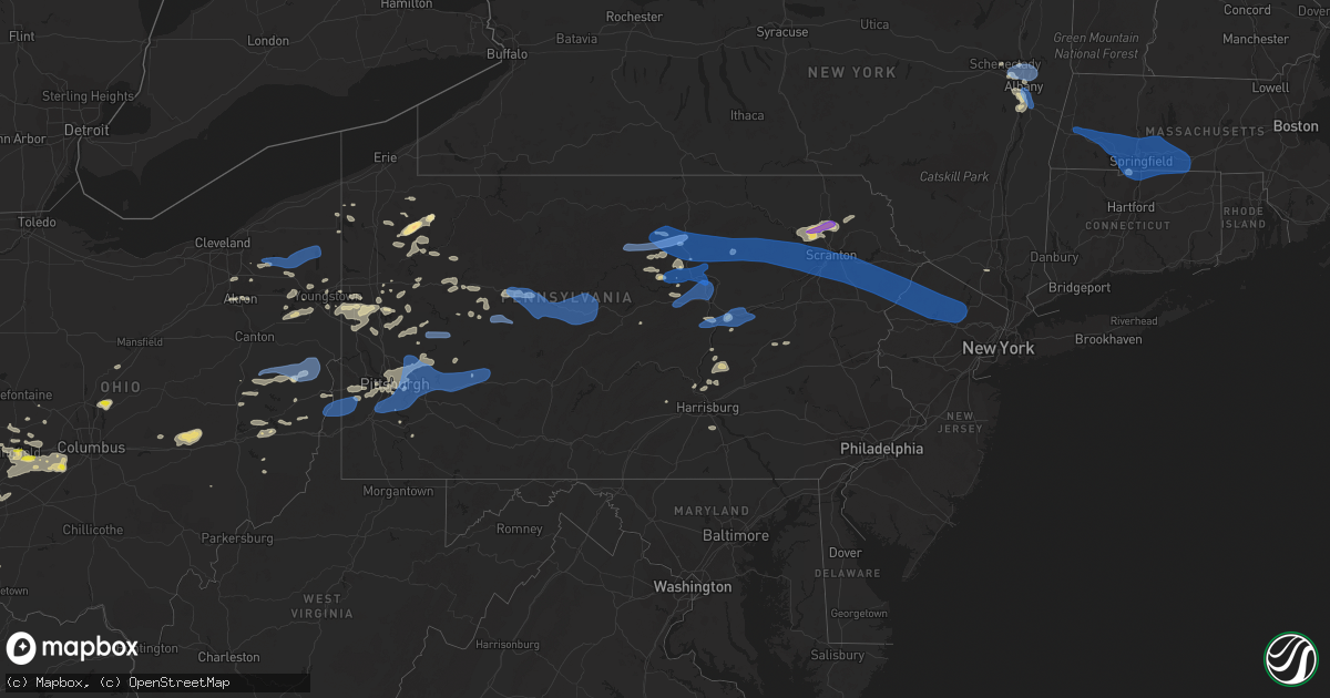
Hail Map in Pennsylvania on August 12, 2021
Get this storm
August 12 map
$229
one time, instant access
Download today. No call, no setup
Keep the $229
Bought the map and want the full workflow? Apply the entire $229 to a subscription within 7 days. None of it is wasted.
Every map, not just this one
This buys you this map. Subscription and you get every map we run, in the markets you choose from a few cities to whole states to nationwide. Plus real-time alerts the moment a storm fires.
Contact data
Name, contact info, occupancy, even credit band for addresses in the footprint. You go from where it hit to who to call.
Become the source they trust
Unlimited branding weather history reports on demand. You already have the documented answer ready for the property owner, and you are the one who showed up with it.
Property data and RoofTrace estimates
Pull up any address you have got, its value and the exact code rules for that jurisdiction, straight from One Click Code. Then RoofTrace estimates the squares, pitch, and roof value, priced the way you price.
Storm reports in Pennsylvania
Pennsylvania
| Date | Description |
|---|---|
| 08/12/20216:50 PM CDT | Trees and wires down |
| 08/12/20216:50 PM CDT | Tree/wires down |
| 08/12/20216:45 PM CDT | Several trees and power lines down in penn township |
| 08/12/20216:45 PM CDT | Trees down |
| 08/12/20216:43 PM CDT | Trees and lines down at thomsville and parkwood in peters twp |
| 08/12/20216:42 PM CDT | County officials have reported several trees and lines down in peters township |
| 08/12/20216:41 PM CDT | Report and photos of snapped trees in delmont. |
| 08/12/20216:40 PM CDT | Trees and wires down |
| 08/12/20216:37 PM CDT | Several trees and power lines down around cecil township |
| 08/12/20216:32 PM CDT | Trees across road |
| 08/12/20216:31 PM CDT | Report of uprooted trees in the area. |
| 08/12/20216:23 PM CDT | Tree across road |
| 08/12/20216:20 PM CDT | Tree down on labelle vue rd. In vandergrift |
| 08/12/20216:18 PM CDT | Lines down on applewood dr and garvers ferry in lower burrell |
| 08/12/20216:17 PM CDT | Tree down on 7th st. Extension in trafford |
| 08/12/20216:14 PM CDT | Report of large tree branches down. |
| 08/12/20216:11 PM CDT | Tree down on sleepy hollow rd in mt lebanon |
| 08/12/20216:09 PM CDT | Trees and wires down |
| 08/12/20216:09 PM CDT | Report of trees down. Time estimated based on radar. |
| 08/12/20216:07 PM CDT | Tree down on trailer on werner camp road |
| 08/12/20216:05 PM CDT | Several trees and lines reported down in allegheny township |
| 08/12/20216:04 PM CDT | Tree down on mayview rd in bridgeville |
| 08/12/20216:00 PM CDT | Report of downed trees. Time estimated based on radar. |
| 08/12/20215:58 PM CDT | Tree down across dutch road |
| 08/12/20215:47 PM CDT | Several trees down in the area... Including on burgettstown rd in mt pleasant township |
| 08/12/20215:43 PM CDT | Lines and tree down on highway 322 near detrick road |
| 08/12/20215:40 PM CDT | Report of lots of trees down and power outages... With picture of downed tree along 5th avenue. |
| 08/12/20215:38 PM CDT | Nws employee witnessed a downburst cross from moon township and coraopolis...across the ohio river...and proceed into osborne/haysville between 634 and 639 pm. This eve |
| 08/12/20215:38 PM CDT | Report of power line and tree down. Time estimated based on radar. |
| 08/12/20215:38 PM CDT | Trees and wires down between haysville light and glen mitchell road. |
| 08/12/20215:37 PM CDT | Trees and power lines down at the intersection of beaver st and glen mitchell rd |
| 08/12/20215:35 PM CDT | Large tree limbs and branches down. |
| 08/12/20215:34 PM CDT | Rough estimate of around 20 trees down by rmus campus |
| 08/12/20215:10 PM CDT | Tree on a vehicle |
| 08/12/20215:06 PM CDT | Trees and wires down |
| 08/12/20215:05 PM CDT | Trees and wires down |
| 08/12/20215:04 PM CDT | Report of several trees and lines down in the area of cranberry township |
| 08/12/20215:01 PM CDT | Photo of large uprooted tree on settlers village circle. Time estimated based on radar. |
| 08/12/20215:00 PM CDT | Report of many downed or broken trees. Time estimated based on radar. |
| 08/12/20214:52 PM CDT | Spotter reported several trees down along or near route 168 in eastbrook |
| 08/12/20214:45 PM CDT | Tree down on power lines in brookville off church st |
| 08/12/20214:40 PM CDT | Tree fell onto a house severely damaging the home near summit township in western crawford county. A mobile home was severely damaged. Numerous trees were blown down. T |
| 08/12/20214:38 PM CDT | Report of power line and tree down. Time estimated based on radar. |
| 08/12/20214:30 PM CDT | Multiple reports of trees and power lines down |
| 08/12/20214:30 PM CDT | Lawrence county public safety reports several trees down in the area... Including the city of new castle. |
| 08/12/20214:28 PM CDT | Delayed report tree down onto a house on brittany dr. |
| 08/12/20214:18 PM CDT | Delayed report. Approximately golf ball-size hail per photo. Time estimated via radar. |
| 08/12/20214:15 PM CDT | Lawrence county public safety reports several trees down in the area... Including the city of new wilmington. |
| 08/12/20214:14 PM CDT | Delayed report. Approximately golf ball-size hail per photo. Time estimated via radar. |
| 08/12/20213:49 PM CDT | Trees down in rockland twp |
| 08/12/20212:25 PM CDT | Trees blown down in scotrun. Time estimated from radar. |
| 08/12/20212:15 PM CDT | Tree down across route 435. |
| 08/12/20212:15 PM CDT | Multiple reports of trees and wires down in the pocono lake area. Time estimated from radar. |
| 08/12/20212:10 PM CDT | Mping report of a tree uprooted or snapped. Time estimated from radar. |
| 08/12/20212:10 PM CDT | Tree and wires blown down on ranger trail near tobyhanna. |
| 08/12/20211:48 PM CDT | Wires down on hillside road. Time estimated from radar. |
| 08/12/20211:26 PM CDT | Multiple reports of wires down. Time estimated from radar. |
| 08/12/20211:12 PM CDT | Trees down and garage door blown in. Images sent via facebook. |
| 08/12/20211:05 PM CDT | Multiple trees down. |
| 08/12/202112:55 PM CDT | Multiple wires down. |
| 08/12/202112:42 PM CDT | Several trees and power lines down in punxsutawney |
| 08/12/202112:40 PM CDT | Multiple trees reported down on power lines in the area of young township |
| 08/12/202112:38 PM CDT | Reported multiple trees down on hamilton porter rd and ewing rd in perry township |
| 08/12/202112:35 PM CDT | Multiple wires down on roadway. |
| 08/12/202112:25 PM CDT | Report of trees down in and around west kittanning. |
| 08/12/202112:25 PM CDT | Trees and wires down. |
| 08/12/202112:15 PM CDT | Tree down. |
| 08/12/202112:15 PM CDT | Multiple trees and wires down. |
| 08/12/202111:00 AM CDT | Trees down |
| 08/12/202110:55 AM CDT | Trees down |
| 08/12/202110:45 AM CDT | Trees down |
| 08/12/20217:56 AM CDT | At 1256 PM EDT, a severe thunderstorm was located near Sarver, or 8 miles southeast of Butler, moving southeast at 40 mph. HAZARD...60 mph wind gusts. SOURCE...Radar indicated. IMPACT...Expect damage to trees and power lines, resulting in some power outages. Locations impacted include... Vandergrift, Kittanning, Apollo, Harrison Township, Ford City, Leechburg, Sarver, Freeport, West Kittanning, Saxonburg, North Apollo, and West Leechburg. |
| 08/12/20217:51 AM CDT | At 1251 PM EDT, severe thunderstorms were located along a line extending from near Leetonia to near Ole Bull State Park to near Kettle Creek State Park, moving east at 40 mph. HAZARD...60 mph wind gusts. SOURCE...Radar indicated. IMPACT...Expect damage to roofs, siding, and trees. Locations impacted include... Morris, Blossburg, Renovo, South Renovo, Arnot, Cross Fork, Glen Union, Waterville, Leonard Harrison State Park, Tamarack, Kettle Creek State Park, Cedar Run, Cammal, Ole Bull State Park, Little Pine State Park, Westport, Leetonia, Cherry Springs State Park, Hyner and Ogdensburg. |
| 08/12/20217:34 AM CDT | At 1234 PM EDT, a severe thunderstorm was located over Leetsdale, or over Moon Township, moving southeast at 40 mph. HAZARD...60 mph wind gusts. SOURCE...Radar indicated. IMPACT...Expect damage to trees and power lines, resulting in some power outages. Locations impacted include... Pittsburgh, Penn Hills, Mount Lebanon, Ross Township, McCandless Township, Cranberry, Moon Township, Franklin Park, Aliquippa, Monaca, Shaler Township, and Plum. |
| 08/12/20217:21 AM CDT | At 1220 PM EDT, a severe thunderstorm was located near Slippery Rock, or 11 miles south of Grove City, moving east at 45 mph. HAZARD...60 mph wind gusts and quarter size hail. SOURCE...Radar indicated. IMPACT...Minor hail damage to vehicles is possible. Expect wind damage to trees and power lines, resulting in some power outages. Locations impacted include... Cranberry, Butler, Kittanning, Rimersburg, New Kensington, Lower Burrell, Harrison Township, Homeacre-Lyndora, Shanor-Northvue, Tarentum, Natrona Heights, and Meridian. |
| 08/12/20216:59 AM CDT | At 1159 AM EDT, a severe thunderstorm was located near New Castle, moving southeast at 40 mph. HAZARD...60 mph wind gusts. SOURCE...Radar indicated. IMPACT...Expect damage to trees and power lines, resulting in some power outages. Locations impacted include... New Castle, Ellwood City, Homeacre-Lyndora, Shanor-Northvue, Meridian, Zelienople, Oakwood, Evans City, New Castle Northwest, Big Beaver, New Beaver, and Ellport. |
| 08/12/20216:10 AM CDT | At 1109 PM EDT, severe thunderstorms were located along a line extending from Lawn to near Valley Green, moving east at 25 mph. HAZARD...60 mph wind gusts and penny size hail. SOURCE...Radar indicated. IMPACT...Expect damage to roofs, siding, and trees. Locations impacted include... Ephrata, Elizabethtown, Lititz, Middletown, Mount Joy, Manheim, East Petersburg, Cornwall, Salunga-Landisville, Denver, Maytown, Campbelltown, Valley Green, Reamstown, Rothsville, Adamstown, Rheems, Bainbridge, Brickerville and Schaefferstown.This includes the following Interstates... The Pennsylvania Turnpike from mile markers 252 to 285. Interstate 83 from mile markers 29 to 32. |
| 08/12/20216:01 AM CDT | At 1101 AM EDT, severe thunderstorms were located along a line extending from near North Bloomfield to near Bristolville to near Newton Falls, moving east at 50 mph. HAZARD...70 mph wind gusts. SOURCE...Radar indicated. IMPACT...Expect considerable tree damage. Damage is likely to mobile homes, roofs, and outbuildings. Locations impacted include... Warren, Niles, Hubbard, Cortland, Lordstown, Kinsman, North Bloomfield, West Farmington, Vienna Center, Adamsville, Pymatuning Central, Bristolville, Leavittsburg, Atlantic, Girard, Vienna, McDonald, Mecca, Johnston and Cochranton. |
| 08/12/20215:31 AM CDT | At 1031 PM EDT, severe thunderstorms were located along a line extending from near Aristes to near Fort Indiantown Gap, moving northeast at 55 mph. HAZARD...60 mph wind gusts. SOURCE...Radar indicated. IMPACT...Expect damage to roofs, siding, and trees. Locations impacted include... Pottsville, Colonial Park, Shamokin, Tamaqua, Linglestown, Mount Carmel, Schuylkill Haven, Shenandoah, Minersville, Mahanoy City, Frackville, St. Clair, Kulpmont, Ashland, Paxtonia, Skyline View, Orwigsburg, Valley View, Mcadoo and Pine Grove.This includes the following Interstates... Interstate 78 from mile markers 0 to 8. Interstate 81 between mile markers 71 and 72...and from mile markers75 to 139. |
| 08/12/20215:27 AM CDT | At 1026 PM EDT, severe thunderstorms were located along a line extending from near Numidia to near Palmyra, moving northeast at 45 mph. HAZARD...60 mph wind gusts. SOURCE...Radar indicated. IMPACT...Damage to roofs, siding, trees, and power lines is possible. Locations impacted include... Hamburg, Womelsdorf, Weatherly, Wernersville, Robesonia, Bernville, Strausstown, Lansford, Beaver Meadows, Centerport and Tresckow.This includes Interstate 78 in Pennsylvania near mile marker 8, andbetween mile markers 10 and 31. |
| 08/12/20214:59 AM CDT | At 958 PM EDT, severe thunderstorms were located along a line extending from Rebuck to Marysville, moving east at 40 mph. HAZARD...60 mph wind gusts. SOURCE...Radar indicated. IMPACT...Expect damage to roofs, siding, and trees. Locations impacted include... Shamokin, Linglestown, Mount Carmel, Kulpmont, Ashland, Skyline View, Valley View, Millersburg, Marysville, Elysburg, Fairview-Ferndale, Trevorton, Lykens, Tremont, Duncannon, Girardville, Elizabethville, Marshallton, Williamstown and Tower City.This includes the following Interstates... Interstate 78 from mile markers 0 to 3. Interstate 81 from mile markers 75 to 117. |
| 08/12/20214:56 AM CDT | At 956 PM EDT, a severe thunderstorm was located over Factoryville, or near Waverly, moving east at 40 mph. HAZARD...60 mph wind gusts and quarter size hail. SOURCE...Radar indicated. IMPACT...Hail damage to vehicles is expected. Expect wind damage to roofs, siding, and trees. Locations impacted include... Scranton, Carbondale, Archbald, Blakely, Dickson City, Olyphant, Clarks Summit, Jessup, Honesdale and Throop. |
| 08/12/20214:31 AM CDT | At 931 PM EDT, a severe thunderstorm was located over Central, or 16 miles northwest of Berwick, moving east at 40 mph. HAZARD...60 mph wind gusts and penny size hail. SOURCE...Radar indicated. IMPACT...Expect damage to roofs, siding, and trees. Locations impacted include... Wilkes-Barre, Muhlenberg, Kingston, Nanticoke, Plains, Pittston, Plymouth, Exeter, Swoyersville and West Pittston. |
| 08/12/20214:23 AM CDT | At 922 PM EDT, severe thunderstorms were located along a line extending from Allenwood to Kreamer, moving east at 45 mph. HAZARD...60 mph wind gusts. SOURCE...Radar indicated. IMPACT...Expect damage to roofs, siding, and trees. Locations impacted include... Bloomsburg, Berwick, Sunbury, Milton, Lewisburg, Selinsgrove, Danville, Northumberland, Winfield, Watsontown, Elysburg, Riverside, Shamokin Dam, Catawissa, Linntown, Hummels Wharf, Middleburg, Mifflinville, Lightstreet and Almedia.For those driving on Interstate 80, this includes areas between theMile Run and Nescopek exits, specifically from mile markers 208 to247.This includes Interstate 180 from mile markers 1 to 3. |
| 08/12/20214:14 AM CDT | At 914 PM EDT, a severe thunderstorm was located 7 miles southeast of Overton, or 15 miles southwest of Wyalusing, moving east at 40 mph. HAZARD...60 mph wind gusts and penny size hail. SOURCE...Radar indicated. IMPACT...Expect damage to roofs, siding, and trees. Locations impacted include... Falls, Vernon, Rush, Harveys Lake, Tunkhannock, Wilmot, Hollenback, Noxen, Mehoopany and Wyalusing. |
| 08/12/20214:01 AM CDT | At 901 PM EDT, a severe thunderstorm was located over Allenwood, moving northeast at 30 mph. HAZARD...60 mph wind gusts and penny size hail. SOURCE...Radar indicated. IMPACT...Expect damage to roofs, siding, and trees. Locations impacted include... Muncy, Watsontown, Hughesville, Montgomery, Allenwood, Biggertown, Lairdsville, Delaware Run and Picture Rocks.For those driving on Interstate 80, this includes areas between theMile Run and Lewisburg-Williamsport exits, specifically from milemarkers 204 to 207.This includes Interstate 180 from mile markers 4 to 17. |
| 08/12/20213:58 AM CDT | At 857 PM EDT, a severe thunderstorm was located over Donora, or 8 miles southeast of Gastonville, moving east at 25 mph. HAZARD...60 mph wind gusts. SOURCE...Radar indicated. IMPACT...Expect damage to trees and power lines, resulting in some power outages. Locations impacted include... Pittsburgh, Monroeville, Greensburg, McKeesport, Jeannette, Latrobe, West Mifflin, Murrysville, Munhall, Jefferson Hills, North Versailles, and Pleasant Hills. |
| 08/12/20213:42 AM CDT | At 842 PM EDT, severe thunderstorms were located along a line extending from Mill Hall to near Rebersburg to Coburn, moving northeast at 30 mph. HAZARD...60 mph wind gusts and penny size hail. SOURCE...Radar indicated. IMPACT...Expect damage to roofs, siding, and trees. Locations impacted include... Williamsport, Lock Haven, Jersey Shore, Mifflinburg, Carroll, Woodward, Lamar, Mill Hall, Avis, Dunnstown, Flemington, Duboistown, Castanea, Millheim, Aaronsburg, McElhattan, Rebersburg, Vicksburg, Coburn and Madisonburg.For those driving on Interstate 80, this includes areas between theLamar and Lewisburg-Williamsport exits, specifically from milemarkers 173 to 204.This includes Interstate 180 from mile markers 24 to 29. |
| 08/12/20213:28 AM CDT | At 827 PM EDT, a severe thunderstorm was located over Cogan Station, moving east at 45 mph. HAZARD...60 mph wind gusts and nickel size hail. SOURCE...Radar indicated. IMPACT...Expect damage to roofs, siding, and trees. Locations impacted include... Williamsport, Montoursville, Hughesville, Kettle Creek Gorge, Cogan Station, Ricketts Glen State Park, Biggertown, Muncy Valley, Barbours, Loyalsockville, Garden View, Picture Rocks, Laporte, Salladasburg, Forksville, Eagles Mere and Hillsgrove.This includes Interstate 180 from mile markers 17 to 23. |
| 08/12/20213:05 AM CDT | At 805 PM EDT, severe thunderstorms were located along a line extending from near Ralston to near Cammal, moving east at 45 mph. HAZARD...60 mph wind gusts and penny size hail. SOURCE...Radar indicated. IMPACT...Expect damage to roofs, siding, and trees. Locations impacted include... Glen Union, Waterville, Ralston, Ogdensburg, Cammal, Slate Run, English Center, Trout Run, Lincoln Falls, Shunk, Little Pine State Park, Buttonwood and Ski Sawmill Ski Area. |
| 08/12/20212:56 AM CDT | At 755 PM EDT, a severe thunderstorm was located over North Philipsburg, moving east at 40 mph. HAZARD...60 mph wind gusts. SOURCE...Law enforcement. IMPACT...Expect damage to roofs, siding, and trees. Locations impacted include... Bellefonte, Pleasant Gap, Philipsburg, Woodland, Lamar, Lemont, Zion, Houserville, Centre Hall, Milesburg, Chester Hill, Snow Shoe, North Philipsburg, Clarence, South Philipsburg, Moshannon, Spring Mills, Julian, Bald Eagle State Park and Potters Mills.For those driving on Interstate 80, this includes areas between theWoodland and Lamar exits, specifically from mile markers 123 to 170.This includes Interstate 99 from mile markers 73 to 85. |
| 08/12/20212:53 AM CDT | At 753 PM EDT, a severe thunderstorm was located near Imperial, or 7 miles southwest of Moon Township, moving east at 45 mph. HAZARD...60 mph wind gusts. SOURCE...Radar indicated. IMPACT...Expect damage to trees and power lines, resulting in some power outages. Locations impacted include... Pittsburgh, Penn Hills, Ross Township, McCandless Township, Moon Township, Franklin Park, Shaler Township, Plum, North Side Pittsburgh, Hampton Township, Scott Township, and Robinson Township. |
| 08/12/20212:43 AM CDT | At 743 PM EDT, a severe thunderstorm was located over Indiana, moving east at 50 mph. HAZARD...60 mph wind gusts. SOURCE...Radar indicated. IMPACT...Expect damage to trees and power lines, resulting in some power outages. Locations impacted include... Indiana, Homer City, Clymer, West Lebanon, Chevy Chase Heights, Ernest, Marion Center, Cherry Tree, Creekside, Plumville, Glen Campbell, and Shelocta. |
| 08/12/20212:09 AM CDT | At 709 PM EDT, severe thunderstorms were located along a line extending from New Kensington to Baldwin to near Wolfdale, moving east at 35 mph. HAZARD...60 mph wind gusts. SOURCE...Radar indicated. IMPACT...Expect damage to trees and power lines, resulting in some power outages. Locations impacted include... Pittsburgh, Penn Hills, Mount Lebanon, Bethel Park, Monroeville, McMurray, Greensburg, McKeesport, Washington, Jeannette, Canonsburg, and Latrobe. |
| 08/12/20212:07 AM CDT | At 707 PM EDT, severe thunderstorms were located along a line extending from 7 miles west of Portland Mills to Reynoldsville to Punxsutawney, moving east at 45 mph. HAZARD...60 mph wind gusts. SOURCE...Radar indicated. IMPACT...Expect damage to roofs, siding, and trees. Locations impacted include... St. Marys, DuBois, Clearfield, Ridgway, Sandy, Woodland, Curwensville, Penfield, Hyde, Plymptonville, Rockton, Houtzdale, Force, Benezette, Jeffries, Lecontes Mills, S.B. Elliot State Park, Medix Run, Portland Mills and Brandy Camp.For those driving on Interstate 80, this includes areas between theDubois and Kylertown exits, specifically from mile markers 97 to 128. |
| 08/12/20211:53 AM CDT | At 653 PM EDT, severe thunderstorms were located along a line extending from 8 miles northeast of Tionesta to 8 miles south of Marienville to Brookville, moving east at 25 mph. HAZARD...60 mph wind gusts. SOURCE...Radar indicated. IMPACT...Expect damage to trees and power lines, resulting in some power outages. Locations impacted include... Brookville, Marienville, Brockway, Falls Creek, Sigel, Kellettville, West Hickory, Clarington, Clear Creek State Park, East Hickory, and Starr. |
| 08/12/20211:40 AM CDT | At 640 PM EDT, a severe thunderstorm was located 7 miles west of Tiltonsville, or 8 miles northwest of Clearview, moving east at 45 mph. HAZARD...60 mph wind gusts. SOURCE...Radar indicated. IMPACT...Expect damage to trees and power lines, resulting in some power outages. Locations impacted include... Weirton, Steubenville, Martins Ferry, Wellsburg, West Liberty, Avella, Clearview, Wintersville, Mingo Junction, Follansbee, Hooverson Heights, and Tiltonsville. |
| 08/12/20211:38 AM CDT | At 637 PM EDT, severe thunderstorms were located along a line extending from near New Bethlehem to near Hampton Township, moving east at 40 mph. HAZARD...60 mph wind gusts. SOURCE...Radar indicated. IMPACT...Expect damage to trees and power lines, resulting in some power outages. Locations impacted include... Indiana, Punxsutawney, Vandergrift, Kittanning, Apollo, Hampton Township, New Kensington, Lower Burrell, Harrison Township, Tarentum, Natrona Heights, and Brackenridge. |
| 08/12/20211:25 AM CDT | At 625 PM EDT, a severe thunderstorm was located over S.B. Elliot State Park, moving east at 20 mph. HAZARD...60 mph wind gusts and penny size hail. SOURCE...Radar indicated. IMPACT...Expect damage to roofs, siding, and trees. Locations impacted include... Clearfield, Philipsburg, Woodland, Curwensville, Hyde, Osceola Mills, Plymptonville, Chester Hill, Karthaus, Jeffries, Lecontes Mills, S.B. Elliot State Park, Morrisdale, West Decatur, Grassflat, Kylertown, Wallaceton and Clearfield-Lawrence Airport.For those driving on Interstate 80, this includes areas between theDubois Route 255 and Snow Shoe exits, specifically from mile markers106 to 138. |
| 08/12/20211:10 AM CDT | At 608 PM EDT, a severe thunderstorm was located 8 miles west of Knox, moving east at 30 mph. HAZARD...60 mph wind gusts. SOURCE...Radar indicated. IMPACT...Expect damage to trees and power lines, resulting in some power outages. Locations impacted include... Clarion, Brookville, Knox, Parker, Sligo, Emlenton, Strattanville, Summerville, Limestone, Shippenville, St. Petersburg, and Corsica. |
| 08/12/20211:06 AM CDT | At 606 PM EDT, a severe thunderstorm was located over Wintersville, or over Steubenville, moving east at 25 mph. HAZARD...60 mph wind gusts. SOURCE...Radar indicated. IMPACT...Expect damage to trees and power lines, resulting in some power outages. Locations impacted include... Weirton, Steubenville, Wellsburg, Avella, Toronto, Wintersville, Mingo Junction, Follansbee, Hooverson Heights, Burgettstown, Franklin, and Hickory. |
| 08/12/202112:53 AM CDT | At 553 PM EDT, a severe thunderstorm was located over Zelienople, or near Cranberry, moving east at 30 mph. HAZARD...60 mph wind gusts. SOURCE...Radar indicated. IMPACT...Expect damage to trees and power lines, resulting in some power outages. Locations impacted include... Cranberry, Butler, Homeacre-Lyndora, Shanor-Northvue, Meridian, Zelienople, Seven Fields, Meadowood, Oak Hills, Sarver, Evans City, and Freeport. |
| 08/12/202112:46 AM CDT | At 544 PM EDT, severe thunderstorms were located along a line extending from near Reynoldsville to near Brockway, moving east at 20 mph. HAZARD...60 mph wind gusts and penny size hail. SOURCE...Radar indicated. IMPACT...Expect damage to roofs, siding, and trees. Locations impacted include... DuBois, Sandy, Penfield, Rockton, Force, Parker Dam State Park, S.B. Elliot State Park, Brockport, Treasure Lake and Penn State Dubois.For those driving on Interstate 80, this includes areas between theDubois and Clearfield exits, specifically from mile markers 97 to113. |
| 08/12/202112:43 AM CDT | At 543 PM EDT, a severe thunderstorm was located 7 miles west of Slippery Rock, or 8 miles east of New Castle, moving east at 35 mph. HAZARD...60 mph wind gusts. SOURCE...Radar indicated. IMPACT...Expect damage to trees and power lines, resulting in some power outages. Locations impacted include... Shanor-Northvue, Slippery Rock, Chicora, Harrisville, Parker, Plain Grove Township, Bruin, West Liberty, Eau Claire, Harlansburg, Portersville, and Petrolia. |
| 08/12/202112:36 AM CDT | At 536 PM EDT, severe thunderstorms were located along a line extending from near Cambridge Springs to near Kinsman, moving east at 35 mph. HAZARD...60 mph wind gusts and quarter size hail. SOURCE...Radar indicated. IMPACT...Minor damage to vehicles is possible. Expect damage to trees and power lines. Locations impacted include... Meadville, Titusville, Cambridge Springs, Linesville, Adamsville, Canadohta Lake, Pymatuning Central, Riceville, Harmonsburg, Lincolnville, Guys Mills, Atlantic, Pymatuning North, Cochranton, Saegertown, Conneaut Lake, Jamestown, Hydetown, Blooming Valley and Townville. |
| 08/12/202112:20 AM CDT | At 520 PM EDT, a severe thunderstorm was located near Brookville, moving east at 15 mph. HAZARD...60 mph wind gusts. SOURCE...Radar indicated. IMPACT...Expect damage to trees and power lines, resulting in some power outages. Locations impacted include... Brookville, Reynoldsville, Falls Creek, Summerville, Corsica, Sigel, Fisher, and Clear Creek State Park. |
| 08/12/202112:12 AM CDT | At 512 PM EDT, a severe thunderstorm was located near Titusville, moving northeast at 25 mph. HAZARD...60 mph wind gusts and nickel size hail. SOURCE...Radar indicated. IMPACT...Expect damage to roofs, siding, and trees. Locations impacted include... Enterprise, Garland, Grand Valley and Tidioute. |
| 08/12/202112:06 AM CDT | At 506 PM EDT, a severe thunderstorm was located near Harmonsburg, or 11 miles west of Meadville, moving east at 25 mph. HAZARD...60 mph wind gusts and quarter size hail. SOURCE...Radar indicated. IMPACT...Minor damage to vehicles is possible. Expect damage to trees and power lines. Locations impacted include... Meadville, Cambridge Springs, Linesville, Riceville, Harmonsburg, Lincolnville, Guys Mills, Pymatuning North, Canadohta Lake, Pymatuning Central, Saegertown, Conneautville, Conneaut Lake, Springboro, Blooming Valley, Venango, Woodcock and Conneaut Lakeshore. |
| 08/11/202111:58 PM CDT | At 458 PM EDT, a severe thunderstorm was located 7 miles east of Guys Mills, or 14 miles northwest of Oil City, moving northeast at 25 mph. HAZARD...60 mph wind gusts and quarter size hail. SOURCE...Radar indicated. IMPACT...Minor damage to vehicles is possible. Expect damage to trees and power lines. Locations impacted include... Titusville, Hydetown and Townville. |
| 08/11/202111:56 PM CDT | At 456 PM EDT, a severe thunderstorm was located near Sugarcreek, or 9 miles north of Franklin, moving east at 30 mph. HAZARD...60 mph wind gusts. SOURCE...Radar indicated. IMPACT...Expect damage to trees and power lines, resulting in some power outages. Locations impacted include... Oil City, Sugarcreek, Tionesta, Hasson Heights, Rouseville, Cooperstown, Pleasantville, West Hickory, Oil Creek State Park, Starr, and East Hickory. |
| 08/11/202111:46 PM CDT | At 441 PM EDT, a severe thunderstorm was located 9 miles west of Knox, moving east at 20 mph. HAZARD...60 mph wind gusts. SOURCE...Radar indicated. IMPACT...Expect damage to trees and power lines, resulting in some power outages. Locations impacted include... Clarion, Knox, Emlenton, Strattanville, Limestone, Shippenville, Fryburg, Leeper, and Cranberry Township. |
| 08/11/202111:07 PM CDT | At 406 PM EDT, severe thunderstorms were located along a line extending from Montague to near Branchville to Blairstown, moving east at 40 mph. HAZARD...60 mph wind gusts. SOURCE...Radar indicated. IMPACT...Expect damage to trees and power lines. Locations impacted include... New City, West Milford, Monsey, Nanuet, Ramsey, Ringwood, Haverstraw, Pompton Lakes, Suffern, Port Jervis, Monroe, West Point, Warwick, Goshen and Sloatsburg. |
| 08/11/202110:33 PM CDT | At 333 PM EDT, severe thunderstorms were located along a line extending from Ledgerdale to near Canadensis to McMichael, moving east at 50 mph. HAZARD...60 mph wind gusts. SOURCE...Law enforcement. At around 3:25 PM, downed trees were reported in Tobyhanna. These storms have a history of producing wind damage. IMPACT...Damage to roofs, siding, trees, and power lines is possible. Locations impacted include... Newton, Montague, Hopatcong, East Stroudsburg, Blairstown, Franklin, Stanhope, Hamburg, Ogdensburg, Sussex, Hope, Branchville, Andover, Stormville, High Point, Henryville, Lake Mohawk, Werry Lake, Greendell and Millbrook.People at the New Jersey State Fair should seek safe shelterimmediately!This includes the following highways... Interstate 80 in Pennsylvania between mile markers 306 and 314. Interstate 80 in New Jersey between mile markers 0 and 24. |
| 08/11/202110:10 PM CDT | Tree down. |
| 08/11/20219:59 PM CDT | At 258 PM EDT, severe thunderstorms were located along a line extending from La Plume to near Scranton to near Bear Creek Village to near Mountain Top, moving southeast at 60 mph. HAZARD...60 mph wind gusts and penny size hail. SOURCE...Radar indicated. IMPACT...Expect damage to roofs, siding, and trees. Locations impacted include... Scranton, Wilkes-Barre, Falls, Dunmore, Kingston, Nanticoke, Plains, Old Forge, Pittston and Archbald. |
| 08/11/20219:56 PM CDT | At 255 PM EDT, severe thunderstorms were located along a line extending from near Old Forge to near Glendale to near Penobscot, moving east at 30 mph. HAZARD...60 mph wind gusts. SOURCE...Law enforcement. These storms have a history of producing wind damage across north-central Pennsylvania. IMPACT...Damage to roofs, siding, trees, and power lines is possible. Locations impacted include... Mount Pocono, East Stroudsburg, Tobyhanna, Stormville, Henryville, Pocono Pines, Pocono Raceway, Lake Harmony, Skytop, Tannersville, Mountainhome, Alpine Mountain, Long Pond, Albrightsville, Sun Valley, Arrowhead Lake, Meckesville, Reeders, Analomink and McMichael.This includes the following highways... Northeast Extension between mile markers 88 and 97. Interstate 80 in Pennsylvania between mile markers 277 and 310. Interstate 380 in Pennsylvania between mile markers 0 and 13. |
| 08/11/20219:50 PM CDT | Tree down blocking wolf creek road. Time estimated from radar. |
| 08/11/20219:45 PM CDT | Tree down on perkins pond road. Via dispatch scanner. Radar-estimated time. |
| 08/11/20219:38 PM CDT | Tree across i-81 blocking roadway. |
| 08/11/20219:23 PM CDT | Tree down on road... Via dispatch scanner feed. Radar estimated time. |
| 08/11/20219:18 PM CDT | Tree down on stanton drive. Via dispatch scanner. Radar estimated time. |
| 08/11/20219:15 PM CDT | Tree and wires down on roadway... Via dispatch scanner. Radar estimated time. |
| 08/11/20219:15 PM CDT | Tree down on hickory ridge road of greenfield township. Via dispatch scanner. Radar-estimated time. |
| 08/11/20219:15 PM CDT | Trees across road. |
| 08/11/20219:14 PM CDT | At 212 PM EDT, severe thunderstorms were located along a line extending from near New Albany to 6 miles northwest of Ricketts Glen State Park to near Biggertown, moving east at 60 mph. HAZARD...70 mph wind gusts. SOURCE...Radar indicated. IMPACT...Expect considerable tree damage. Damage is likely to mobile homes, roofs, and outbuildings. Locations impacted include... Scranton, Wilkes-Barre, Falls, Muhlenberg, Dunmore, Kingston, Nanticoke, Plains, Old Forge and Pittston. |
| 08/11/20219:05 PM CDT | Tree down on seminary road. Via dispatch scanner. Radar-estimated time. |
| 08/11/20219:00 PM CDT | Large tree down on highway 11. Radar estimated time. |
| 08/11/20219:00 PM CDT | Trees on wires |
| 08/11/20219:00 PM CDT | Multiple branches and small trees down. Radar-estimated time. |
| 08/11/20218:47 PM CDT | At 146 PM EDT, a severe thunderstorm was located near Waterville, moving east at 30 mph. HAZARD...60 mph wind gusts and nickel size hail. SOURCE...Radar indicated. IMPACT...Expect damage to roofs, siding, and trees. Locations impacted include... Williamsport, Jersey Shore, Avis, Duboistown, Glen Union, Waterville, Cogan Station, Collomsville, Little Pine State Park, South Williamsport, Garden View, Oval and Salladasburg.This includes Interstate 180 from mile markers 27 to 29. |
| 08/11/20218:43 PM CDT | At 142 PM EDT, a severe thunderstorm was located near Punxsutawney, moving east at 35 mph. HAZARD...60 mph wind gusts. SOURCE...Radar indicated. IMPACT...Expect damage to roofs, siding, and trees. Locations impacted include... Clearfield, Philipsburg, Woodland, Curwensville, Hyde, Osceola Mills, Plymptonville, Chester Hill, Houtzdale, Jeffries, Morrisdale, Irvona, West Decatur, Coalport, Ramey, Brisbin, Westover, Mahaffey, Grampian and Kylertown.For those driving on Interstate 80, this includes areas between thePenfield and Snow Shoe exits, specifically from mile markers 113 to134. |
| 08/11/20218:33 PM CDT | Trees and power lines down upper raven creek rd. Benton twp. |
| 08/11/20218:30 PM CDT | Report of lots of tree damage and downed limbs. |
| 08/11/20218:30 PM CDT | Trees down across ligonier township. |
| 08/11/20218:27 PM CDT | At 127 PM EDT, severe thunderstorms were located along a line extending from near Ogdensburg to Ralston to near Trout Run, moving east at 45 mph. HAZARD...60 mph wind gusts. SOURCE...Radar indicated. IMPACT...Expect damage to roofs, siding, and trees. Locations impacted include... Hughesville, Kettle Creek Gorge, Lairdsville, Ricketts Glen State Park, Ralston, Biggertown, Muncy Valley, Trout Run, Lincoln Falls, Barbours, Shunk, Loyalsockville, Picture Rocks, Dushore, Laporte, Forksville, Eagles Mere and Hillsgrove. |
| 08/11/20218:26 PM CDT | At 126 PM EDT, a severe thunderstorm was located near Punxsutawney, moving east at 30 mph. HAZARD...60 mph wind gusts. SOURCE...Radar indicated. IMPACT...Expect damage to trees and power lines, resulting in some power outages. Locations impacted include... Punxsutawney, Big Run, Dayton, Rossiter, Marion Center, Cherry Tree, Plumville, Glen Campbell, Timblin, Commodore, Dixonville, and Worthville. |
| 08/11/20218:25 PM CDT | Power lines down on four mile run rd |
| 08/11/20218:25 PM CDT | Trees and wires down |
| 08/11/20218:15 PM CDT | Trees and wires down |
| 08/11/20218:05 PM CDT | At 105 PM EDT, a severe thunderstorm was located over New Bethlehem, or 11 miles southeast of Rimersburg, moving southeast at 35 mph. HAZARD...60 mph wind gusts and quarter size hail. SOURCE...Radar indicated. IMPACT...Minor hail damage to vehicles is possible. Expect wind damage to trees and power lines, resulting in some power outages. Locations impacted include... Punxsutawney, New Bethlehem, Dayton, Hawthorn, Plumville, Timblin, Worthville, Smicksburg, Rochester Mills, Mahoning Creek Lake, Anita, and Distant. |
| 08/11/20217:49 PM CDT | Several reports of trees and wires down in the williamsport area and surrounding townships. |
| 08/11/20217:45 PM CDT | Tree down on washington pike in independence township |
| 08/11/20217:40 PM CDT | Trees down |
| 08/11/20217:36 PM CDT | Trees down |
| 08/11/20217:34 PM CDT | Tree across road |
| 08/11/20217:30 PM CDT | *** 1 inj *** vehicle struck a fallen tree. |
| 08/11/20217:26 PM CDT | Trees and wires down |
| 08/11/20217:08 PM CDT | *** 1 inj *** several trees down and one individual severely injured by a fallen tree. |
All States Impacted by Hail Map on August 12, 2021
Cities Impacted by Hail Map on August 12, 2021
- Orient, OH
- Mount Sterling, OH
- Grove City, OH
- London, OH
- Galloway, OH
- South Solon, OH
- Cedarville, OH
- Yellow Springs, OH
- West Jefferson, OH
- South Charleston, OH
- South Vienna, OH
- Springfield, OH
- Munden, KS
- Sullivan, IN
- Merom, IN
- Edinburg, PA
- New Castle, PA
- Hillsville, PA
- Morrisonville, IL
- Overland Park, KS
- Pittsburgh, PA
- Shawnee, KS
- Oakdale, IL
- Coulterville, IL
- Syracuse, KS
- Leavenworth, KS
- Norfolk, CT
- Holdrege, NE
- Kansas City, MO
- Hoyt, KS
- Topeka, KS
- Oblong, IL
- Annapolis, IL
- Martinsville, IL
- Limon, CO
- Sterling, KS
- Hutchinson, KS
- Nickerson, KS
- Raymond, KS
- Chase, KS
- Lyons, KS
- Sabetha, KS
- Bern, KS
- Oskaloosa, KS
- East Lynne, MO
- Garden City, MO
- Harrisonville, MO
- Ayr, NE
- Lawrence, NE
- Blue Hill, NE
- Linwood, KS
- De Soto, KS
- Harvel, IL
- Liverpool, IL
- Canton, IL
- Polo, MO
- Lawson, MO
- Shoals, IN
- Tampa, KS
- Springfield, IL
- Nashport, OH
- Zanesville, OH
- Feeding Hills, MA
- West Suffield, CT
- Suffield, CT
- Southwick, MA
- Clarion, PA
- Sligo, PA
- Saint Louis, MO
- Mittie, LA
- Jermyn, PA
- Carbondale, PA
- Factoryville, PA
- Nicholson, PA
- Fleetville, PA
- Dalton, PA
- Tunkhannock, PA
- Ness City, KS
- West Jefferson, NC
- Millers Creek, NC
- Purlear, NC
- Portersville, PA
- Slippery Rock, PA
- Pulaski, PA
- Moweaqua, IL
- Assumption, IL
- Bethany, IL
- Wallace, KS
- Sharon Springs, KS
- Weskan, KS
- Lucas, KS
- Sylvan Grove, KS
- Selden, KS
- Browning, IL
- Hamilton, MO
- Winston, MO
- Gallatin, MO
- Kidder, MO
- Elsberry, MO
- Silex, MO
- Clarksville, MO
- Eolia, MO
- Bowling Green, MO
- Colby, KS
- Levant, KS
- Winona, KS
- Monument, KS
- Arapahoe, NE
- Oxford, NE
- Edison, NE
- Swanton, NE
- Western, NE
- Hillsboro, KS
- Lehigh, KS
- Newton, KS
- Goessel, KS
- Hoxie, KS
- Rexford, KS
- Union City, OH
- Union City, IN
- Montgomery City, MO
- New Florence, MO
- Dighton, KS
- Wilcox, NE
- Stockton, KS
- Emporia, KS
- Morris, PA
- Concordia, KS
- Jamestown, KS
- Hydetown, PA
- Centerville, PA
- Guys Mills, PA
- Cooperstown, PA
- Titusville, PA
- Grand Valley, PA
- Indianola, NE
- Bartley, NE
- Cambridge, NE
- Vona, CO
- McDonald, PA
- Burgettstown, PA
- Bulger, PA
- Morrowville, KS
- Linn, KS
- Norborne, MO
- Lexington, MO
- Axtell, KS
- Baileyville, KS
- Amsterdam, OH
- Powhattan, KS
- Netawaka, KS
- Wetmore, KS
- Tallmadge, OH
- Akron, OH
- Peyton, CO
- Ansonia, OH
- Scott City, KS
- Marienthal, KS
- Corning, KS
- Centralia, KS
- Seneca, KS
- Montverde, FL
- Clermont, FL
- Clemmons, NC
- Wathena, KS
- Mayview, MO
- Wellington, MO
- Odessa, MO
- Overton, NV
- Home, KS
- Grainfield, KS
- Grinnell, KS
- Oakley, KS
- Dolan Springs, AZ
- Bonner Springs, KS
- Basehor, KS
- Sturgeon, PA
- Steinauer, NE
- Burchard, NE
- Pawnee City, NE
- Lawrence, KS
- Moundridge, KS
- Hesston, KS
- Meadows Of Dan, VA
- Stuart, VA
- Floyd, VA
- Willis, VA
- Lebanon, TN
- Hartsville, TN
- Riddleton, TN
- Hurtsboro, AL
- Auburn, NE
- Dawson, NE
- Verdon, NE
- Stella, NE
- Shubert, NE
- Texline, TX
- Cameron, MO
- Pawnee, IL
- Poseyville, IN
- Tulia, TX
- Barnesville, OH
- Sherrodsville, OH
- Bowerston, OH
- Dennison, OH
- Adams, NE
- Pickrell, NE
- Cortland, NE
- Firth, NE
- Bedford, IN
- Heltonville, IN
- Norman, IN
- Minneola, KS
- Greenville, MO
- Hildebran, NC
- Connelly Springs, NC
- Hickory, NC
- Sibley, MO
- Oak Grove, MO
- Napoleon, MO
- Grain Valley, MO
- Blue Springs, MO
- Jefferson, NC
- Milton, PA
- Northumberland, PA
- Craig, MO
- Ellsworth, KS
- Kanopolis, KS
- Peculiar, MO
- Waldo, KS
- Paradise, KS
- Stanford, IL
- Minier, IL
- Cheyenne Wells, CO
- Lincoln, KS
- Forest City, PA
- Union Dale, PA
- Waymart, PA
- Waterville, KS
- Barnes, KS
- Natoma, KS
- Victoria, KS
- Gorham, KS
- Walnut, MS
- Worthville, KY
- Owenton, KY
- Berryton, KS
- Hays, KS
- Lorraine, KS
- Goff, KS
- Horton, KS
- Montrose, IA
- Keokuk, IA
- Adamsville, OH
- Hopewell, OH
- Frazeysburg, OH
- Dresden, OH
- Marquette, KS
- Little River, KS
- Cochranton, PA
- West Mifflin, PA
- Homestead, PA
- Braddock, PA
- Lecompton, KS
- Quinter, KS
- Holly, CO
- Albany, NY
- Guilderland, NY
- Schenectady, NY
- Abilene, KS
- Argyle, IA
- Kahoka, MO
- Wayland, MO
- Silverton, TX
- Soldier, KS
- Havensville, KS
- Plainville, KS
- Mooresville, MO
- Breckenridge, MO
- Russell, KS
- Bunker Hill, KS
- Lansing, NC
- Warrensville, NC
- Jamesport, MO
- Augusta, KS
- Summerville, PA
- Strattanville, PA
- Marysville, OH
- Palmer, IL
- Owaneco, IL
- Taylorville, IL
- Kampsville, IL
- Hamburg, IL
- Winfield, MO
- Foley, MO
- Nebo, IL
- Troy, MO
- Moscow Mills, MO
- Annada, MO
- Hutsonville, IL
- Robinson, IL
- Ellis, KS
- Boulder City, NV
- Barnard, KS
- Lewisberry, PA
- Dover, PA
- York Haven, PA
- Abernathy, TX
- Anton, TX
- Littlefield, TX
- Pomona, KS
- Greenup, IL
- Casey, IL
- Concordia, MO
- Whitewater, KS
- Burns, KS
- Potwin, KS
- Karval, CO
- Hugo, CO
- Ferrum, VA
- Axtell, NE
- Hildreth, NE
- Cowgill, MO
- Richmond, MO
- Falls City, NE
- Woodston, KS
- Olathe, KS
- Sarasota, FL
- Trinidad, CO
- Matheson, CO
- Bucyrus, KS
- Freeport, OH
- Kimbolton, OH
- Du Bois, NE
- Excelsior Springs, MO
- Corder, MO
- Seligman, AZ
- Holton, KS
- Effingham, KS
- Muscotah, KS
- Valley Falls, KS
- Ransom, KS
- Sheridan Lake, CO
- Fairview, KS
- Cogan Station, PA
- Eudora, KS
- Quenemo, KS
- Ottawa, KS
- Vassar, KS
- Overbrook, KS
- Weston, MO
- Platte City, MO
- Portis, KS
- New Philadelphia, PA
- Brockton, PA
- Lakin, KS
- Kendall, KS
- Marquand, MO
- Bergholz, OH
- Gardner, KS
- Emlenton, PA
- Kennerdell, PA
- Stockport, IA
- Smith Center, KS
- Braymer, MO
- Dawn, MO
- Senoia, GA
- Plymouth, NE
- Collyer, KS
- Ogallah, KS
- Wakeeney, KS
- Arapahoe, CO
- Leoti, KS
- Iola, TX
- Tonganoxie, KS
- Franklin, PA
- Nortonville, KS
- Ferguson, NC
- Wilkesboro, NC
- Lawrenceville, IL
- Union Springs, AL
- Parrish, FL
- Manito, IL
- Topeka, IL
- Forest City, IL
- Havana, IL
- Luray, KS
- Evans City, PA
- Prospect, PA
- Harmony, PA
- Renfrew, PA
- Butler, PA
- West Sunbury, PA
- Highland, IL
- Oil City, PA
- Milford Center, OH
- Whiting, KS
- Durham, KS
- Andover, OH
- Mayport, PA
- Coolspring, PA
- Brookville, PA
- Sprankle Mills, PA
- Punxsutawney, PA
- Morrill, KS
- Hiawatha, KS
- Deer Trail, CO
- Canaan, CT
- East Canaan, CT
- Tecumseh, NE
- Johnson, NE
- Elk Creek, NE
- Alma, MO
- Blackburn, MO
- Healy, KS
- Ariton, AL
- De Witt, NE
- Clatonia, NE
- Oregon, MO
- Wilber, NE
- Daykin, NE
- Fenton, MO
- Osborne, KS
- Onaga, KS
- Pleasant Hill, MO
- Atchison, KS
- Cummings, KS
- Ohiowa, NE
- Strang, NE
- Bradford, IL
- Putnam, IL
- Kansas City, KS
- Hamilton, KS
- Marshall, IL
- Mcpherson, KS
- Galva, KS
- Lithonia, GA
- Natchitoches, LA
- Natchez, LA
- Robeline, LA
- McCook, NE
- Winchester, IN
- Flagler, CO
- Castleton On Hudson, NY
- Selkirk, NY
- Glenmont, NY
- Warren, OH
- Mineral Ridge, OH
- Niles, OH
- Gypsum, KS
- Ramer, AL
- Montgomery, AL
- De Kalb, MO
- Grenola, KS
- Howard, KS
- Altamont, MO
- Smithville, MO
- Lees Summit, MO
- Buckner, MO
- Independence, MO
- Genoa, CO
- Sherman, IL
- Trout Run, PA
- Kit Carson, CO
- Vincennes, IN
- Sunbury, OH
- Centerburg, OH
- Sullivan, IL
- Versailles, OH
- Lutz, FL
- Tampa, FL
- Odessa, FL
- Vermillion, KS
- Summerfield, KS
- Dearborn, MO
- Olney, IL
- Robinson, KS
- Everest, KS
- Hamel, IL
- Edwardsville, IL
- Worden, IL
- Table Rock, NE
- Troy, KS
- Medora, IL
- Hackberry, AZ
- Roseland, NE
- Glenvil, NE
- Bladen, NE
- Deerfield, OH
- Mercer, MO
- Sainte Genevieve, MO
- Conover, OH
- Fletcher, OH
- Saint Paris, OH
- Jonesburg, MO
- Eureka, KS
- Virgil, KS
- Saint Petersburg, FL
- Lewistown, IL
- Tescott, KS
- Beverly, KS
- Agate, CO
- Hays, NC
- McGrady, NC
- Carthage, TN
- Gaylord, KS
- Winsted, CT
- Pontiac, IL
- Flanagan, IL
- Virden, IL
- Piedmont, KS
- Latham, KS
- Belleville, KS
- Brookville, OH
- Salina, KS
- Williams, AZ
- Frankfort, KS
- Reading, KS
- Pinnacle, NC
- Westfield, NC
- Pilot Mountain, NC
- Cantrall, IL
- Stratton, CO
- Knox, PA
- Shippenville, PA
- Piper City, IL
- Humboldt, NE
- Girard, IL
- Pendleton, KY
- La Grange, KY
- Walton, KS
- Canton, KS
- Peabody, KS
- Dumas, TX
- Clifton Park, NY
- Rexford, NY
- Warrenton, MO
- Edinburg, IL
- Kincaid, IL
- Mound City, MO
- Bolckow, MO
- White Cloud, KS
- Rulo, NE
- Maitland, MO
- Savannah, MO
- Bendena, KS
- Lancaster, KS
- Amazonia, MO
- Nemaha, NE
- Highland, KS
- Denton, KS
- Fillmore, MO
- Forest City, MO
- Potosi, MO
- Belgrade, MO
- Lenexa, KS
- Linden, PA
- Saint Joseph, MO
- Faucett, MO
- Agency, MO
- Laurel, IN
- Greensburg, IN
- Moores Hill, IN
- Milan, IN
- Quitaque, TX
- North Benton, OH
- Beloit, OH
- Berlin Center, OH
- Coventry, CT
- Storrs Mansfield, CT
- Tolland, CT
- Willington, CT
- Meadville, PA
- Beloit, KS
- Columbia, IL
- Burrton, KS
- Halstead, KS
- Buhler, KS
- Lawsonville, NC
- Old Town, FL
- Esbon, KS
- Lebanon, KS
- Madison, KS
- Olpe, KS
- Chillicothe, MO
- Freeburg, IL
- Quaker City, OH
- Lagrange, GA
- Linesville, PA
- Muncy Valley, PA
- Hettick, IL
- Greenfield, IL
- Wauchula, FL
- Simla, CO
- Oberlin, KS
- Bruning, NE
- Lykens, PA
- Wiconisco, PA
- Liberty, NE
- Dillonvale, OH
- Adena, OH
- Cadiz, OH
- Heath, OH
- Madison, FL
- Palmetto, FL
- Ellenton, FL
- Herndon, PA
- Bath, IL
- Greenville, OH
- Medora, IN
- Rochester, IL
- Chatham, IL
- Bradenton, FL
- Rhineland, MO
- Oakmont, PA
- Cheswick, PA
- Leechburg, PA
- Apollo, PA
- Tarentum, PA
- Natrona Heights, PA
- Creighton, PA
- Verona, PA
- Brackenridge, PA
- Vandergrift, PA
- Glenshaw, PA
- Freeport, PA
- Indianola, PA
- Allison Park, PA
- Harwick, PA
- Springdale, PA
- New Kensington, PA
- Spring Glen, PA
- Gratz, PA
- Halifax, PA
- Elizabethville, PA
- Bushnell, IL
- Marietta, IL
- Torrington, CT
- Falls Village, CT
- Salem, NE
- Newton Falls, OH
- Garrettsville, OH
- Southington, OH
- Windham, OH
- Adrian, MO
- Archie, MO
- Weatherby, MO
- Wellsville, KS
- Baldwin City, KS
- Alexandria, NE
- Peninsula, OH
- Alhambra, IL
- Jersey Shore, PA
- Newcomerstown, OH
- Port Washington, OH
- Lansing, KS
- Marissa, IL
- Addieville, IL
- Mascoutah, IL
- Fenelton, PA
- Tobias, NE
- Athens, IL
- Riverton, IL
- Perry, KS
- Conroe, TX
- Brookville, IN
- Metamora, IN
- Connersville, IN
- Albert, KS
- Rushville, MO
- Marion, KS
- Rensselaer, NY
- Danvers, IL
- Bates City, MO
- Allerton, IA
- Hardin, MO
- Danbury, NE
- Paris, IL
- Houston, TX
- Stilwell, KS
- Grandview, MO
- Dover, MO
- Orrick, MO
- Lone Jack, MO
- Henrietta, MO
- Levasy, MO
- New Century, KS
- Higginsville, MO
- Waverly, MO
- Raymore, MO
- McLouth, KS
- Mission, KS
- Belton, MO
- Carrollton, MO
- Camden, MO
- Leawood, KS
- Cuba, IL
- Smithfield, IL
- Burdick, KS
- Dalmatia, PA
- Pillow, PA
- Batchtown, IL
- Donnellson, IA
- Farmington, IA
- Fredericktown, OH
- Mount Gilead, OH
- Carbon, IN
- Rosedale, IN
- Fredericktown, MO
- Falls Creek, PA
- Rockton, PA
- Reynoldsville, PA
- Du Bois, PA
- Geneva, NE
- Turners Station, KY
- Lexington, NC
- Norridgewock, ME
- Madison, ME
- Anson, ME
- French Lick, IN
- West Baden Springs, IN
- Spring Hill, KS
- Paola, KS
- Louisburg, KS
- Danville, PA
- Lenoxville, PA
- Falls, PA
- Olyphant, PA
- Edgerton, MO
- Bicknell, IN
- Hanover, KS
- Admire, KS
- West Middlesex, PA
- Hubbard, OH
- Pana, IL
- Shelbyville, IL
- Ironton, MO
- Annapolis, MO
- Callaway, VA
- Bristol, FL
- Fort Leavenworth, KS
- Hoxie, AR
- Walnut Ridge, AR
- Portia, AR
- Deweese, NE
- Fairfield, NE
- Lovington, IL
- Midway, AL
- Jonesville, KY
- Glencoe, KY
- Dry Ridge, KY
- Blountstown, FL
- Hope, KS
- Townville, PA
- Mantua, OH
- Chagrin Falls, OH
- Aurora, OH
- North Jackson, OH
- Blairsville, PA
- Youngstown, OH
- Lowellville, OH
- Gnadenhutten, OH
- Uhrichsville, OH
- Park, KS
- Kingston, MO
- Luray, MO
- Mount Sterling, IA
- Bonaparte, IA
- Liberal, MO
- Modesto, IL
- Waverly, IL
- New Liberty, KY
- Milligan, NE
- McCracken, KS
- Belleville, IL
- East Saint Louis, IL
- Granada, CO
- Henry, IL
- Denison, KS
- Landisburg, PA
- Shermans Dale, PA
- Bowling Green, IN
- Florissant, MO
- Mcconnelsville, OH
- Mascotte, FL
- Howey In The Hills, FL
- Groveland, FL
- Winfield, PA
- Lewisburg, PA
- Pella, IA
- Otley, IA
- Youngstown, FL
- Vernon, FL
- Panama City, FL
- Pattonsburg, MO
- Bethany, MO
- McFall, MO
- Leon, KS
- Holyrood, KS
- Carlisle, IN
- Gordonsville, TN
- Spickard, MO
- Washington, KS
- Haddam, KS
- Avonmore, PA
- Spring Church, PA
- Shelocta, PA
- Astoria, IL
- East Carondelet, IL
- Dupo, IL
- Thonotosassa, FL
- Duncannon, PA
- Volant, PA
- Joffre, PA
- Oakdale, PA
- Edgewood, IL
- Dalhart, TX
- Union City, PA
- Marysville, KS
- Leitchfield, KY
- Lock Haven, PA
- Cammal, PA
- Waterville, PA
- Chrisman, IL
- Lewis, IN
- Shelburn, IN
- Downs, KS
- Climax Springs, MO
- Roach, MO
- Claudville, VA
- Ringgold, VA
- Ipava, IL
- Table Grove, IL
- Carrollton, OH
- Alton, KS
- Alliance, OH
- Salem, OH
- Canfield, OH
- Sebring, OH
- Flushing, OH
- Saint Clairsville, OH
- Green, KS
- Randolph, KS
- Newton, IL
- Matfield Green, KS
- Americus, KS
- Vienna, OH
- Grove City, PA
- Brussels, IL
- Saint Charles, MO
- Portage Des Sioux, MO
- Campbell, NE
- Hermann, MO
- Wenona, IL
- Ancona, IL
- Long Point, IL
- Dana, IL
- Mechanicsburg, OH
- Catawba, OH
- Fowler, KS
- Lesterville, MO
- New Port Richey, FL
- Holiday, FL
- Keosauqua, IA
- Revere, MO
- Blue Rapids, KS
- Yadkinville, NC
- Wilmington, OH
- Xenia, OH
- Jamestown, OH
- Deep Gap, NC
- Statesville, NC
- Easton, IL
- Lewisburg, OH
- West Manchester, OH
- Monongahela, PA
- Charleroi, PA
- Woodrow, CO
- Riverside, MO
- Mitchell, IN
- Tunnelton, IN
- Winston Salem, NC
- Galt, MO
- Madisonville, TX
- Louisville, KY
- Spring Hill, FL
- Dawson, IL
- Clifton, KS
- Oakland, IL
- Hindsboro, IL
- Schodack Landing, NY
- Sunbury, PA
- Jewett, OH
- Woolwine, VA
- Salesville, OH
- Winchester, KS
- Danbury, NC
- Shallowater, TX
- Williamsport, PA
- Finleyville, PA
- Amelia, OH
- Mingo Junction, OH
- Follansbee, WV
- Steubenville, OH
- Colliers, WV
- Hidalgo, IL
- Arcanum, OH
- New Madison, OH
- Hilliards, PA
- Boyers, PA
- Harrisville, PA
- Cabot, PA
- Sarver, PA
- Brownstown, IN
- Parker, PA
- Pekin, IL
- Macomb, IL
- Industry, IL
- Bryant, IL
- Adair, IL
- Saint David, IL
- Glasford, IL
- Pinellas Park, FL
- Carrollton, IL
- New Wilmington, PA
- Rayville, MO
- New Philadelphia, OH
- Trenton, MO
- Humphreys, MO
- Lickingville, PA
- Tionesta, PA
- Fryburg, PA
- Dallas City, IL
- Jacksonville, IL
- Minneapolis, KS
- Glasco, KS
- Delphos, KS
- Presto, PA
- Bridgeville, PA
- Carnegie, PA
- Kilbourne, IL
- Goodview, VA
- Vinton, VA
- Chula, MO
- Neoga, IL
- Delmar, NY
- Springboro, PA
- Conneautville, PA
- Circleville, KS
- Dubois, IN
- Goodwell, OK
- Utica, PA
- Carlton, PA
- Murrayville, IL
- Franklin, IL
- Happy, TX
- Colorado Springs, CO
- Wright City, MO
- Chino Valley, AZ
- Stewartsville, MO
- Osborn, MO
- Findlay, IL
- Salem, VA
- Woodlawn, VA
- Seminole, PA
- New Bethlehem, PA
- Maysville, MO
- Kane, IL
- Nevada, MO
- Piedmont, OH
- Camden Point, MO
- Hudson, OH
- Streetsboro, OH
- Bucklin, KS
- Rocky Mount, VA
- Lyons, IN
- Sandborn, IN
- Coeymans, NY
- Slingerlands, NY
- Ravena, NY
- Bushton, KS
- Ellinwood, KS
- Nashville, IN
- Advance, NC
- Brundidge, AL
- Spring Mills, PA
- Prairie Village, KS
- Crittenden, KY
- Edgar, NE
- Ong, NE
- Thurmond, NC
- Dobson, NC
- Gove, KS
- Mullinville, KS
- Potts Camp, MS
- Melvern, KS
- Lyndon, KS
- Easton, KS
- Utica, KS
- Freeman, MO
- Lincolnville, KS
- Kinsley, KS
- Urbana, OH
- Hardy, VA
- Conyers, GA
- Chicora, PA
- East Brady, PA
- Worthington, PA
- Jamestown, TN
- Catharine, KS
- Mount Orab, OH
- Frankfort, KY
- Bruceville, IN
- Karns City, PA
- Perryopolis, PA
- Grindstone, PA
- Oketo, KS
- Tribune, KS
- Gay, GA
- Concord, GA
- Pierpont, OH
- Butler, MO
- Normangee, TX
- Holstein, NE
- Stamford, NE
- Tilden, IL
- Sparta, IL
- Floyd, NM
- Scranton, KS
- Carbondale, KS
- Troy, AL
- Corsica, PA
- Newman, IL
- Greenwood, MO
- Hallam, NE
- Ludlow, MO
- Myrtle, MS
- New Albany, MS
- Princeton, MO
- Gilman City, MO
- Glen Elder, KS
- Pittsburg, KS
- Cypress, TX
- Conchas Dam, NM
- Dauphin, PA
- Tecumseh, KS
- Grantville, KS
- Cherokee, AL
- Gower, MO
- Alma, NE
- Ellington, MO
- Paxinos, PA
- Farmersville, IL
- Lake Milton, OH
- Diamond, OH
- Brownstown, IL
- Edgerton, KS
- Toledo, IL
- Bostic, NC
- Lewisville, OH
- Mason City, IL
- San Jose, IL
- Port Saint Joe, FL
- Jetmore, KS
- Cimarron, KS
- Pleasantville, PA
- Cleveland, MO
- Creighton, MO
- Abbeville, MS
- Oxford, MS
- Pottsville, PA
- Saint Clair, PA
- Lock Springs, MO
- Wheeling, MO
- Silva, MO
- Hogansville, GA
- Wampum, PA
- Ellwood City, PA
- West Pittsburg, PA
- New Galilee, PA
- Enon Valley, PA
- New Middletown, OH
- Bessemer, PA
- Leesville, OH
- Salineville, OH
- Scio, OH
- Canyon, TX
- Ona, FL
- McKees Rocks, PA
- Enterprise, KS
- North Lewisburg, OH
- Woodstock, OH
- Cable, OH
- Normal, IL
- Bloomington, IL
- Camargo, IL
- Fombell, PA
- Fort Montgomery, NY
- Timblin, PA
- Guilford, MO
- Linton, IN
- Jasonville, IN
- Lamar, CO
- Hunter, KS
- Vandalia, MO
- Maryland Heights, MO
- Curryville, MO
- Clarence, MO
- Shelbina, MO
- Bartelso, IL
- Crystal City, MO
- Stoutsville, MO
- Frankford, MO
- New Canton, IL
- Wellsville, MO
- Bellflower, MO
- Santa Fe, MO
- House Springs, MO
- Percy, IL
- Trenton, IL
- Campbell Hill, IL
- Red Bud, IL
- Albers, IL
- Martinsburg, MO
- Ashley, IL
- Rockport, IL
- Lentner, MO
- Richview, IL
- Eureka, MO
- Centralia, IL
- High Hill, MO
- O'Fallon, IL
- Saint Libory, IL
- Ashburn, MO
- Valmeyer, IL
- Walsh, IL
- High Ridge, MO
- Rush Hill, MO
- Ballwin, MO
- Golden Eagle, IL
- Chester, IL
- Saint Peters, MO
- Truxton, MO
- Holliday, MO
- Baldwin, IL
- Lebanon, IL
- Paris, MO
- Rockwood, IL
- Cutler, IL
- Summerfield, IL
- Saint Mary, MO
- Prairie Du Rocher, IL
- Perryville, MO
- Monroe City, MO
- Wildwood, MO
- Old Monroe, MO
- Festus, MO
- Saint Ann, MO
- Benton City, MO
- Pacific, MO
- Pevely, MO
- New Baden, IL
- Aviston, IL
- Laddonia, MO
- Bridgeton, MO
- Hull, IL
- Palmyra, MO
- Lake Saint Louis, MO
- Barnhart, MO
- Modoc, IL
- Ellis Grove, IL
- O'Fallon, MO
- Centralia, MO
- Perry, MO
- Hawk Point, MO
- Kinderhook, IL
- Valley Park, MO
- Millstadt, IL
- Hannibal, MO
- Scott Air Force Base, IL
- Arnold, MO
- Evansville, IL
- Breese, IL
- Bloomsdale, MO
- New London, MO
- Carlyle, IL
- Fults, IL
- Thompson, MO
- Foristell, MO
- Hecker, IL
- Middletown, MO
- Defiance, MO
- Mexico, MO
- Pleasant Hill, IL
- Madison, MO
- Okawville, IL
- Hoyleton, IL
- Herculaneum, MO
- Center, MO
- Nashville, IL
- Chesterfield, MO
- Farber, MO
- Pinckneyville, IL
- Lenzburg, IL
- Steeleville, IL
- Louisiana, MO
- New Athens, IL
- Smithton, IL
- Germantown, IL
- Hunnewell, MO
- Imperial, MO
- Waterloo, IL
- Wentzville, MO
- Liberty, MO
- Amsterdam, MO
- Amoret, MO
- La Cygne, KS
- Drexel, MO
- North Bloomfield, OH
- Hiram, OH
- West Farmington, OH
- Burton, OH
- Middlefield, OH
- Cortland, OH
- Bristolville, OH
- Mineral City, OH
- Dellroy, OH
- Wellsville, OH
- Richmond, OH
- Mechanicstown, OH
- Irondale, OH
- Hammondsville, OH
- Muncy, PA
- Loganton, PA
- White Deer, PA
- Montgomery, PA
- Rebersburg, PA
- New Columbia, PA
- Mifflinburg, PA
- Allenwood, PA
- Watsontown, PA
- Hickory, PA
- Wellsburg, WV
- Claysville, PA
- Beech Bottom, WV
- Bethany, WV
- Brilliant, OH
- Avella, PA
- Atlasburg, PA
- Rayland, OH
- Wheeling, WV
- Selinsgrove, PA
- Shamokin Dam, PA
- New Berlin, PA
- Bloomsburg, PA
- Catawissa, PA
- Riverside, PA
- Willow Beach, AZ
- Wilbraham, MA
- Springfield, MA
- Bondsville, MA
- West Brookfield, MA
- Sturbridge, MA
- Ware, MA
- Blandford, MA
- Holyoke, MA
- Becket, MA
- Lenox Dale, MA
- East Longmeadow, MA
- West Springfield, MA
- Hinsdale, MA
- West Warren, MA
- Enfield, CT
- Hampden, MA
- Longmeadow, MA
- Palmer, MA
- Chicopee, MA
- Fiskdale, MA
- Easthampton, MA
- Granby, MA
- South Hadley, MA
- Wales, MA
- Russell, MA
- Holland, MA
- Huntington, MA
- Florence, MA
- Brimfield, MA
- Southampton, MA
- Somers, CT
- Chester, MA
- Lenox, MA
- Agawam, MA
- Monson, MA
- Three Rivers, MA
- Stafford Springs, CT
- Ludlow, MA
- Warren, MA
- Indian Orchard, MA
- Belchertown, MA
- Lee, MA
- Thorndike, MA
- Westfield, MA
- Saybrook, IL
- Versailles, IL
- Chambersburg, IL
- Waterford, NY
- Troy, NY
- Watervliet, NY
- Wynantskill, NY
- Cohoes, NY
- Latham, NY
- Nassau, NY
- East Greenbush, NY
- Mechanicsburg, IL
- Rosamond, IL
- Wheeler, IL
- Mattoon, IL
- Yale, IL
- Sainte Marie, IL
- Sumner, IL
- Willow Hill, IL
- Windsor, IL
- Pleasant Plains, IL
- Stoy, IL
- Strasburg, IL
- Nokomis, IL
- Sigel, IL
- Trilla, IL
- Blue Mound, IL
- Bulpitt, IL
- Stonington, IL
- Gays, IL
- Macon, IL
- Montrose, IL
- Jewett, IL
- West Liberty, IL
- Tower Hill, IL
- Petersburg, IL
- Dushore, PA
- Augusta, NJ
- Riverdale, NJ
- Andover, NJ
- Hawley, PA
- Montoursville, PA
- Oak Ridge, NJ
- Kingston, PA
- Taylor, PA
- Wellsboro, PA
- Plymouth, PA
- Tamiment, PA
- Stockholm, NJ
- Old Forge, PA
- Mehoopany, PA
- Wyoming, PA
- Lincoln Park, NJ
- Sterling, PA
- Branchville, NJ
- Mountain Lakes, NJ
- Hibernia, NJ
- Cresco, PA
- Layton, NJ
- Scranton, PA
- Sweet Valley, PA
- Liberty, PA
- Roaring Branch, PA
- Hillsgrove, PA
- Stanhope, NJ
- Duryea, PA
- Ogdensburg, NJ
- Lake Ariel, PA
- Sparta, NJ
- Hopatcong, NJ
- Harveys Lake, PA
- East Stroudsburg, PA
- Mount Arlington, NJ
- Shunk, PA
- Newfoundland, PA
- Blairstown, NJ
- South Sterling, PA
- Moosic, PA
- Noxen, PA
- Montville, NJ
- Newton, NJ
- Denville, NJ
- West Milford, NJ
- Gouldsboro, PA
- Bloomingdale, NJ
- Henryville, PA
- Franklin, NJ
- Canadensis, PA
- Butler, NJ
- Newfoundland, NJ
- Luzerne, PA
- Wharton, NJ
- Eagles Mere, PA
- Dover, NJ
- Towaco, NJ
- Ralston, PA
- Pittston, PA
- Tobyhanna, PA
- Laporte, PA
- Boonton, NJ
- Pompton Plains, NJ
- Dingmans Ferry, PA
- Blossburg, PA
- Mildred, PA
- Bushkill, PA
- Lafayette, NJ
- Lake Hopatcong, NJ
- Forksville, PA
- Canton, PA
- Lopez, PA
- Columbia, NJ
- Moscow, PA
- Greentown, PA
- Shavertown, PA
- Rockaway, NJ
- Clarks Summit, PA
- Dallas, PA
- Cedar Run, PA
- Hamburg, NJ
- Wilkes Barre, PA
- Kittanning, PA
- Ford City, PA
- Manorville, PA
- Walston, PA
- Glen Campbell, PA
- Rossiter, PA
- Clarence, PA
- Mineral Springs, PA
- Glen Richey, PA
- Kylertown, PA
- Allport, PA
- Hawk Run, PA
- Clearfield, PA
- Morrisdale, PA
- Winburne, PA
- Grassflat, PA
- Luthersburg, PA
- Munson, PA
- Bigler, PA
- Philipsburg, PA
- Curwensville, PA
- Karthaus, PA
- Grampian, PA
- Hyde, PA
- Frenchville, PA
- Osceola Mills, PA
- Lanse, PA
- Woodland, PA
- Drifting, PA
- Snow Shoe, PA
- Penfield, PA
- Wallaceton, PA
- Brockway, PA
- Moshannon, PA
- West Decatur, PA
- West Elizabeth, PA
- South Park, PA
- Turtle Creek, PA
- Indiana, PA
- Glassport, PA
- Elizabeth, PA
- Monroeville, PA
- Black Lick, PA
- Harrison City, PA
- Irwin, PA
- New Alexandria, PA
- Bairdford, PA
- New Florence, PA
- Russellton, PA
- Elrama, PA
- Murrysville, PA
- Ardara, PA
- East Pittsburgh, PA
- Gibsonia, PA
- Greenock, PA
- East McKeesport, PA
- Dravosburg, PA
- Brush Valley, PA
- Delmont, PA
- Slickville, PA
- Derry, PA
- Josephine, PA
- Lawrence, PA
- Wilmerding, PA
- Greensburg, PA
- Coral, PA
- Saltsburg, PA
- Bethel Park, PA
- Clarksburg, PA
- Jeannette, PA
- North Versailles, PA
- Homer City, PA
- Eighty Four, PA
- Pitcairn, PA
- Duquesne, PA
- Clairton, PA
- Canonsburg, PA
- Trafford, PA
- Armagh, PA
- Export, PA
- Mckeesport, PA
- Venetia, PA
- North Bend, PA
- Slate Run, PA
- Cross Fork, PA


