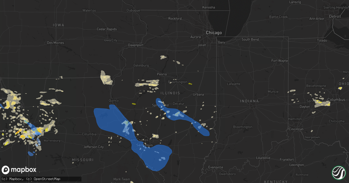
Hail Map in Illinois on August 12, 2021
Get this storm
August 12 map
$229
one time, instant access
Download today. No call, no setup
Keep the $229
Bought the map and want the full workflow? Apply the entire $229 to a subscription within 7 days. None of it is wasted.
Every map, not just this one
This buys you this map. Subscription and you get every map we run, in the markets you choose from a few cities to whole states to nationwide. Plus real-time alerts the moment a storm fires.
Contact data
Name, contact info, occupancy, even credit band for addresses in the footprint. You go from where it hit to who to call.
Become the source they trust
Unlimited branding weather history reports on demand. You already have the documented answer ready for the property owner, and you are the one who showed up with it.
Property data and RoofTrace estimates
Pull up any address you have got, its value and the exact code rules for that jurisdiction, straight from One Click Code. Then RoofTrace estimates the squares, pitch, and roof value, priced the way you price.
Storm reports in Illinois
Illinois
| Date | Description |
|---|---|
| 08/12/20216:54 PM CDT | Large tree blown over onto illinois route 3. |
| 08/12/20215:30 PM CDT | Penny to quarter size hail |
| 08/12/20214:20 PM CDT | Tree limbs down |
| 08/12/20213:50 PM CDT | Power pole knocked down. Time estimated from radar. |
| 08/12/20213:48 PM CDT | Very large tree estimated 3 ft diameter reported broken at the base. Several 2 to 3 in tree limbs reported as well. |
| 08/12/20213:38 PM CDT | Fire department damaged... Metal roof blown off a church... And a tree down on a car. |
| 08/12/20213:30 PM CDT | Several trees damaged. |
| 08/12/20213:27 PM CDT | Several large tree branches down and power outage. Time estimated from radar. |
| 08/12/20213:20 PM CDT | Trained spotter estimated 70-75 mph winds. |
| 08/12/20213:20 PM CDT | Trained spotter reported 70-75 mph wind gusts. |
| 08/12/20213:16 PM CDT | A local report indicates 70 MPH wind near TAYLORVILLE AIRPORT |
| 08/12/20213:15 PM CDT | Branches down north silver st 800 block blocking road. |
| 08/12/20213:10 PM CDT | Large limbs up to 3 in down some of which that have fallen on houses and vehicles. Time estimated from radar. |
| 08/12/20213:10 PM CDT | Personal weather equipment read 58 mph before failing. |
| 08/12/20213:10 PM CDT | Personal weather station read 58 mph before equipment outage |
| 08/12/20213:10 PM CDT | A few trees broken in two... Several limbs down. Weather station recorded gusts of 50 to 75 mph. |
| 08/12/20213:06 PM CDT | Trees uprooted... Extensive tree damage. |
| 08/12/20213:01 PM CDT | Power outages reported. |
| 08/12/20212:48 PM CDT | Large tree split and blown down south of toronto rd on north cotton hill rd. |
| 08/12/20212:48 PM CDT | Report from mping: 1-inch tree limbs broken; shingles blown off. |
| 08/12/20212:48 PM CDT | Large tree down in bridgeview park. |
| 08/12/20212:48 PM CDT | Power pole snapped and tents damaged at state fairgrounds |
| 08/12/20212:48 PM CDT | A local report indicates 60 MPH wind near 2 NW GRANDVIEW |
| 08/12/20212:47 PM CDT | 16 in diameter healthy tree snapped. Several branches down in the same area as well. Time estimated from radar. |
| 08/12/20212:47 PM CDT | 16 in diameter healthy tree snapped. Several branches down in the same area as well. Time estimated from radar. |
| 08/12/20212:45 PM CDT | Report of trees down. |
| 08/12/20212:44 PM CDT | Tree limb down. Time estimated from radar. |
| 08/12/20212:44 PM CDT | Tree limb down on north side of interstate. |
| 08/12/20212:40 PM CDT | Trees down on isles and leonard rd as well as leonard and reed. |
| 08/12/20212:39 PM CDT | 2 to 3 inch tree limbs down - time estimated by radar. |
| 08/12/20219:55 AM CDT | Report of large trees blown down and a gast station sign blown over. Time estimated from radar. |
| 08/12/20215:52 AM CDT | At 1051 AM CDT, a severe thunderstorm was located over Fisher, or 9 miles west of Rantoul, moving east at 15 mph. HAZARD...60 mph wind gusts and quarter size hail. SOURCE...Radar indicated. IMPACT...Hail damage to vehicles is expected. Expect wind damage to roofs, siding, and trees. Locations impacted include... Thomasboro, Rantoul and Gifford.This includes the following highways... Interstate 57 between mile markers 241 and 257. Interstate 74 between mile markers 169 and 172. |
| 08/12/20214:13 AM CDT | At 912 AM CDT, a severe thunderstorm was located over Saybrook, or 7 miles west of Gibson City, moving east at 15 mph. HAZARD...60 mph wind gusts and quarter size hail. SOURCE...Radar indicated. IMPACT...Hail damage to vehicles is expected. Expect wind damage to roofs, siding, and trees. Locations impacted include... Fisher.This includes Interstate 57 between mile markers 249 and 254. |
| 08/12/20213:22 AM CDT | At 821 AM CDT, severe thunderstorms were located along a line extending from 6 miles south of Chatsworth to near Colfax to near Wapella, moving east at 30 mph. HAZARD...60 mph wind gusts and quarter size hail. SOURCE...Radar indicated. IMPACT...Hail damage to vehicles is expected. Expect wind damage to roofs, siding, and trees. Locations impacted include... Paxton, Gibson City, Cissna Park, Buckley, Melvin, Loda, Roberts, Elliott, Sibley, Thawville, Clarence and Claytonville.Including the following interstate... I-57 between mile markers 258 and 277. |
| 08/12/20213:11 AM CDT | At 811 PM CDT, severe thunderstorms were located along a line extending from near Willisville to near Perryville to Womac, moving southeast at 40 mph. HAZARD...60 mph wind gusts. SOURCE...Radar indicated. IMPACT...Expect damage to roofs, siding, and trees. Severe thunderstorms will be near... Perryville around 820 PM CDT. Ava around 825 PM CDT.Other locations in the path of these severe thunderstorms includeAlliance, Murphysboro, Altenburg, Patton and Grand Tower.This includes Interstate 55 between Mile Markers 111 and 131. |
| 08/12/20213:07 AM CDT | At 807 PM CDT, severe thunderstorms were located along a line extending from 7 miles southeast of Carlyle to 6 miles south of Nashville to Percy, moving east at 45 mph. HAZARD...60 mph wind gusts. SOURCE...Radar indicated. IMPACT...Expect damage to roofs, siding, and trees. Severe thunderstorms will be near... Tamaroa around 820 PM CDT.Other locations in the path of these severe thunderstorms includeWoodlawn, Du Quoin and Valier.This includes the following highways... Interstate 57 in Illinois between Mile Markers 81 and 105. Interstate 64 in Illinois between Mile Markers 63 and 85. |
| 08/12/20212:23 AM CDT | At 723 PM CDT, severe thunderstorms were located along a line extending from near Lebanon to Red Bud to near Bonne Terre, moving southeast at 45 mph. HAZARD...60 mph wind gusts. SOURCE...Radar indicated. IMPACT...Expect damage to roofs, siding, and trees. Locations impacted include... Chester, Perryville, Pinckneyville, Tamaroa, Willisville, Cutler, Campbell Hill and Lithium.This includes Interstate 55 between Mile Markers 132 and 139. |
| 08/12/20212:14 AM CDT | At 712 PM CDT, severe thunderstorms were located along a line extending from Shiloh to New Design to near De Soto, moving southeast at 50 mph. HAZARD...70 mph wind gusts. SOURCE...This line of storms has a history of damaging wind gusts. IMPACT...Expect considerable tree damage. Damage is likely to mobile homes, roofs, and outbuildings. Severe thunderstorms will be near... Mascoutah, Lebanon, Red Bud and Scott AFB around 720 PM CDT. New Baden around 725 PM CDT. Albers, Evansville, Baldwin and New Memphis around 730 PM CDT.Other locations in the path of these severe thunderstorms includeBloomsdale, Rocky Ridge, Sparta, Okawville, Weingarten, Ste.Genevieve, Nashville, Steeleville, Percy, Chester and St. Mary.This includes the following highways... Interstate 64 in Illinois between exits 14 and 61. Interstate 55 in Missouri between exits 141 and 174.This also includes Hawn State Park and Felix Valle House State Park. |
| 08/12/20211:30 AM CDT | At 629 PM EDT, severe thunderstorms were located along a line extending from 12 miles southeast of Terre Haute to 6 miles northeast of Lancaster, moving southeast at 25 mph. HAZARD...60 mph wind gusts and quarter size hail. SOURCE...Radar indicated. IMPACT...Hail damage to vehicles is expected. Expect wind damage to roofs, siding, and trees. Locations impacted include... Coalmont, Jasonville, Coal City, Vicksburg, Linton, Worthington and Switz City. |
| 08/12/20211:06 AM CDT | At 606 PM EDT, a severe thunderstorm was located over Sullivan, or 16 miles east of Robinson, moving southeast at 30 mph. HAZARD...60 mph wind gusts and quarter size hail. SOURCE...Radar indicated. IMPACT...Hail damage to vehicles is expected. Expect wind damage to roofs, siding, and trees. This severe thunderstorm will be near... Paxton around 615 PM EDT. Dugger and Carlisle around 620 PM EDT.Other locations in the path of this severe thunderstorm includePleasantville. |
| 08/12/202112:51 AM CDT | At 551 PM CDT, severe thunderstorms were located along a line extending from near Davis to near Treloar to near Mount Sterling, moving southeast at 40 mph. HAZARD...60 mph wind gusts and penny size hail. SOURCE...This line of storms has a history of wind damage. IMPACT...Expect damage to roofs, siding, and trees. Severe thunderstorms will be near... Marthasville and Fountain N' Lakes around 600 PM CDT. Washington, Winfield, Chain of Rocks and Dutzow around 605 PM CDT. Gerald around 610 PM CDT.Other locations in the path of these severe thunderstorms includeAugusta, Villa Ridge, Defiance, Beaufort, Gray Summit, St. Charles,Oak Grove, Sullivan, Pacific, Orchard Farms, Maryland Heights,Eureka, Portage Des Sioux and Miramiguoa Park.This includes the following highways... Interstate 44 in Missouri between exits 228 and 277. Interstate 70 in Missouri between exits 188 and 231.This also includes Babler Memorial State Park, Route 66 State Park,Deutschheim Historic Site, Castlewood State Park, First MissouriState Capitol Historic Site, and Robertsville State Park. |
| 08/12/202112:30 AM CDT | At 530 PM CDT, a severe thunderstorm was located over Meredosia, or 13 miles north of Winchester, moving east at 25 mph. HAZARD...60 mph wind gusts and quarter size hail. SOURCE...Radar indicated. IMPACT...Hail damage to vehicles is expected. Expect wind damage to roofs, siding, and trees. This severe thunderstorm will be near... Exeter around 540 PM CDT. Chapin and Arenzville around 550 PM CDT.Other locations in the path of this severe thunderstorm includeJacksonville.This includes Interstate 72 between mile markers 52 and 66. |
| 08/12/202112:27 AM CDT | At 526 PM CDT, severe thunderstorms were located along a line extending from near Louisiana to near New Hartford to near Wellsville, moving east at 35 mph. HAZARD...60 mph wind gusts and penny size hail. SOURCE...This line of storms has a history of wind damage. IMPACT...Expect damage to roofs, siding, and trees. Severe thunderstorms will be near... Bowling Green and New Hartford around 530 PM CDT. Louisiana around 535 PM CDT. Atlas and Pike around 540 PM CDT. Bellflower around 545 PM CDT.Other locations in the path of these severe thunderstorms includeClarksville, Pleasant Hill, Eolia, Hawk Point, Belleview and Davis.This also includes Cuivre River State Park. |
| 08/11/202111:50 PM CDT | At 450 PM CDT, severe thunderstorms were located along a line extending from 7 miles northwest of Perry to near Santa Fe to near Mexico, moving east at 45 mph. HAZARD...60 mph wind gusts and penny size hail. SOURCE...Radar indicated. IMPACT...Expect damage to roofs, siding, and trees. Severe thunderstorms will be near... Perry around 455 PM CDT. Laddonia around 500 PM CDT. Center and Farber around 505 PM CDT. Vandalia and Martinsburg around 510 PM CDT.Other locations in the path of these severe thunderstorms includeWellsville, Frankford, Curryville, Spencerburg, Montgomery City,Buell, New Hartford, Bowling Green, Bellflower and Tarrants.This also includes Mark Twain Lake Recreational Area. |
| 08/11/202111:45 PM CDT | At 444 PM CDT, severe thunderstorms were located along a line extending from near Quincy Regional Airport to near Hannibal to near Warren, moving southeast at 25 mph. HAZARD...60 mph wind gusts and penny size hail. SOURCE...Radar indicated. IMPACT...Expect damage to roofs, siding, and trees. Severe thunderstorms will be near... Hannibal and Quincy Regional Airport around 450 PM CDT. Payson and Fall Creek around 455 PM CDT.Other locations in the path of these severe thunderstorms includeRensselaer, Beverly, Spaulding, Barry, New London and Center.This includes the following highways... Interstate 172 between exits 2 and 14. Interstate 72 between exits 4 and 31.This also includes Siloam Springs State Park. |
| 08/11/202111:29 PM CDT | At 429 PM CDT, a severe thunderstorm was located over Jewett, or near Toledo, moving southeast at 50 mph. HAZARD...60 mph wind gusts and nickel size hail. SOURCE...Radar indicated. IMPACT...Expect damage to roofs, siding, and trees. This severe thunderstorm will be near... Greenup around 435 PM CDT. Hidalgo around 440 PM CDT. Hazel Dell around 445 PM CDT.Other locations in the path of this severe thunderstorm includeOblong, Eaton and Annapolis.This includes the following highways... Interstate 57 between mile markers 158 and 179. Interstate 70 between mile markers 92 and 131. |
| 08/11/202111:26 PM CDT | At 426 AM CDT, a severe thunderstorm was located near Emden, or 12 miles north of Lincoln, moving southeast at 45 mph. HAZARD...60 mph wind gusts. SOURCE...Radar indicated. IMPACT...Expect damage to roofs, siding, and trees. This severe thunderstorm will be near... Armington around 435 AM CDT. Lincoln and Atlanta around 440 AM CDT. McLean around 445 AM CDT.Other locations in the path of this severe thunderstorm includeBeason.This includes the following highways... Interstate 155 between mile markers 5 and 20. Interstate 55 between mile markers 129 and 145. |
| 08/11/202111:00 PM CDT | At 359 PM EDT, a severe thunderstorm was located over Danville, moving east at 40 mph. HAZARD...60 mph wind gusts. SOURCE...Radar indicated. IMPACT...Expect damage to roofs, siding, and trees. This severe thunderstorm will be near... State Line City and Gessie around 405 PM EDT. Foster around 410 PM EDT. Covington around 415 PM EDT.Other locations in the path of this severe thunderstorm include WestLebanon, Veedersburg and Williamsport.This includes Interstate 74 between mile markers 1 and 14. |
| 08/11/202110:43 PM CDT | At 343 PM CDT, a severe thunderstorm was located over Shelbyville, moving southeast at 50 mph. HAZARD...70 mph wind gusts and quarter size hail. SOURCE...Radar indicated. IMPACT...Hail damage to vehicles is expected. Expect considerable tree damage. Wind damage is also likely to mobile homes, roofs, and outbuildings. This severe thunderstorm will be near... Stewardson and Shumway around 400 PM CDT.Other locations in the path of this severe thunderstorm includeEffingham, Neoga, Teutopolis and Montrose.This includes the following highways... Interstate 57 between mile markers 146 and 190. Interstate 70 between mile markers 79 and 107. |
| 08/11/202110:14 PM CDT | At 314 AM CDT, a severe thunderstorm was located near Towanda, or 9 miles northeast of Bloomington, moving east at 30 mph. HAZARD...60 mph wind gusts and nickel size hail. SOURCE...Radar indicated. IMPACT...Expect damage to roofs, siding, and trees. This severe thunderstorm will be near... Lexington around 325 AM CDT. Cooksville around 330 AM CDT.Other locations in the path of this severe thunderstorm includeColfax.This includes Interstate 55 between mile markers 169 and 186. |
| 08/11/202110:08 PM CDT | At 307 PM CDT, a severe thunderstorm was located near Taylorville, moving southeast at 45 mph. HAZARD...60 mph wind gusts and penny size hail. SOURCE...Radar indicated. IMPACT...Expect damage to roofs, siding, and trees. Locations impacted include... Pana and Tower Hill. |
| 08/11/202110:02 PM CDT | At 302 AM CDT, severe thunderstorms were located along a line extending from Peru to Naplate to Seneca, moving north at 30 mph. HAZARD...60 mph wind gusts. SOURCE...Radar indicated. IMPACT...Expect damage to roofs, siding, and trees. Locations impacted include... Ottawa, Streator, Peru, La Salle, Mendota, Marseilles, Sheridan, Lake Holiday, Oglesby, Seneca, Somonauk, Earlville, North Utica, Serena, Leland, Tonica, Grand Ridge, Naplate, Millington and Dayton.Including the following interstates... I-39 between mile markers 44 and 77. I-80 between mile markers 74 and 102.This includes... Buffalo Rock State Park, Illini State Park,Illinois Valley Community College, Matthiessen State Park, StarvedRock State Park, and Tri-County Fairgrounds. |
| 08/11/20219:43 PM CDT | At 243 PM CDT, a severe thunderstorm was located over Rochester, or near Springfield, moving southeast at 30 mph. HAZARD...60 mph wind gusts and penny size hail. SOURCE...Radar indicated. IMPACT...Expect damage to roofs, siding, and trees. This severe thunderstorm will be near... Mechanicsburg around 250 PM CDT.Other locations in the path of this severe thunderstorm includeEdinburg, Kincaid, Bulpitt, Jeisyville, Taylorville and Stonington.This includes the following highways... Interstate 55 between mile markers 88 and 107. Interstate 72 between mile markers 93 and 120. |
| 08/11/20219:30 PM CDT | At 230 AM CDT, a severe thunderstorm was located near Lakewood Shores, or near Wilmington, moving east at 35 mph. HAZARD...60 mph wind gusts and penny size hail. SOURCE...Radar indicated. IMPACT...Expect damage to roofs, siding, and trees. Locations impacted include... Joliet, Park Forest, Bourbonnais, Channahon, Steger, Manteno, Braidwood, Wilmington, Peotone, Crete, University Park, Manhattan, Monee, Beecher, Diamond, Elwood, Lakewood Shores, Grant Park, Essex and Godley.Including the following interstates... I-55 between mile markers 235 and 246. I-57 between mile markers 318 and 338.This includes... Governors State University, Kankakee River StatePark, and Will County Fairgrounds. |
| 08/11/20219:13 PM CDT | At 212 AM CDT, severe thunderstorms were located along a line extending from Braidwood to near Herscher to near Pontiac, moving east at 40 mph. HAZARD...60 mph wind gusts and nickel size hail. SOURCE...Radar indicated. IMPACT...Expect damage to roofs, siding, and trees. Locations impacted include... Kankakee, Bourbonnais, Bradley, Momence, Herscher, Clifton, Limestone, St. Anne, Chebanse, Ashkum, Aroma Park, Hopkins Park, Cullom, Saunemin, Martinton, Essex, Sun River Terrace, Bonfield, Beaverville and Donovan.Including the following interstate... I-57 between mile markers 289 and 318. This includes... Kankakee Community College, Kankakee CountyFairgrounds and Speedway, Kankakee River State Park, and OlivetNazarine University. |
| 08/11/20218:25 PM CDT | Trees reported down. |
| 08/11/20218:10 PM CDT | 63 mph wind gust reported by a viewers weather station. |
| 08/11/20217:22 PM CDT | Numerous trees and tree limbs blown down around town. |
| 08/11/20217:20 PM CDT | Power lines blown down at the intersection of illinois route 15 and jefferson road. |
| 08/11/20217:10 PM CDT | Numerous tree limbs blown down. Via facebook. |
| 08/11/20217:10 PM CDT | Via twitter photo of small tree uprooted and medium sized tree limb snapped. |
| 08/11/20217:07 PM CDT | Several trees blown down around town. Also... Several power lines were blown down. |
| 08/11/20217:01 PM CDT | A local report indicates 67 MPH wind near 1 NE CAHOKIA |
| 08/11/20217:01 PM CDT | A local report indicates 67 MPH wind near 1 ESE SAUGET |
All States Impacted by Hail Map on August 12, 2021
Cities Impacted by Hail Map on August 12, 2021
- Orient, OH
- Mount Sterling, OH
- Grove City, OH
- London, OH
- Galloway, OH
- South Solon, OH
- Cedarville, OH
- Yellow Springs, OH
- West Jefferson, OH
- South Charleston, OH
- South Vienna, OH
- Springfield, OH
- Munden, KS
- Sullivan, IN
- Merom, IN
- Edinburg, PA
- New Castle, PA
- Hillsville, PA
- Morrisonville, IL
- Overland Park, KS
- Pittsburgh, PA
- Shawnee, KS
- Oakdale, IL
- Coulterville, IL
- Syracuse, KS
- Leavenworth, KS
- Norfolk, CT
- Holdrege, NE
- Kansas City, MO
- Hoyt, KS
- Topeka, KS
- Oblong, IL
- Annapolis, IL
- Martinsville, IL
- Limon, CO
- Sterling, KS
- Hutchinson, KS
- Nickerson, KS
- Raymond, KS
- Chase, KS
- Lyons, KS
- Sabetha, KS
- Bern, KS
- Oskaloosa, KS
- East Lynne, MO
- Garden City, MO
- Harrisonville, MO
- Ayr, NE
- Lawrence, NE
- Blue Hill, NE
- Linwood, KS
- De Soto, KS
- Harvel, IL
- Liverpool, IL
- Canton, IL
- Polo, MO
- Lawson, MO
- Shoals, IN
- Tampa, KS
- Springfield, IL
- Nashport, OH
- Zanesville, OH
- Feeding Hills, MA
- West Suffield, CT
- Suffield, CT
- Southwick, MA
- Clarion, PA
- Sligo, PA
- Saint Louis, MO
- Mittie, LA
- Jermyn, PA
- Carbondale, PA
- Factoryville, PA
- Nicholson, PA
- Fleetville, PA
- Dalton, PA
- Tunkhannock, PA
- Ness City, KS
- West Jefferson, NC
- Millers Creek, NC
- Purlear, NC
- Portersville, PA
- Slippery Rock, PA
- Pulaski, PA
- Moweaqua, IL
- Assumption, IL
- Bethany, IL
- Wallace, KS
- Sharon Springs, KS
- Weskan, KS
- Lucas, KS
- Sylvan Grove, KS
- Selden, KS
- Browning, IL
- Hamilton, MO
- Winston, MO
- Gallatin, MO
- Kidder, MO
- Elsberry, MO
- Silex, MO
- Clarksville, MO
- Eolia, MO
- Bowling Green, MO
- Colby, KS
- Levant, KS
- Winona, KS
- Monument, KS
- Arapahoe, NE
- Oxford, NE
- Edison, NE
- Swanton, NE
- Western, NE
- Hillsboro, KS
- Lehigh, KS
- Newton, KS
- Goessel, KS
- Hoxie, KS
- Rexford, KS
- Union City, OH
- Union City, IN
- Montgomery City, MO
- New Florence, MO
- Dighton, KS
- Wilcox, NE
- Stockton, KS
- Emporia, KS
- Morris, PA
- Concordia, KS
- Jamestown, KS
- Hydetown, PA
- Centerville, PA
- Guys Mills, PA
- Cooperstown, PA
- Titusville, PA
- Grand Valley, PA
- Indianola, NE
- Bartley, NE
- Cambridge, NE
- Vona, CO
- McDonald, PA
- Burgettstown, PA
- Bulger, PA
- Morrowville, KS
- Linn, KS
- Norborne, MO
- Lexington, MO
- Axtell, KS
- Baileyville, KS
- Amsterdam, OH
- Powhattan, KS
- Netawaka, KS
- Wetmore, KS
- Tallmadge, OH
- Akron, OH
- Peyton, CO
- Ansonia, OH
- Scott City, KS
- Marienthal, KS
- Corning, KS
- Centralia, KS
- Seneca, KS
- Montverde, FL
- Clermont, FL
- Clemmons, NC
- Wathena, KS
- Mayview, MO
- Wellington, MO
- Odessa, MO
- Overton, NV
- Home, KS
- Grainfield, KS
- Grinnell, KS
- Oakley, KS
- Dolan Springs, AZ
- Bonner Springs, KS
- Basehor, KS
- Sturgeon, PA
- Steinauer, NE
- Burchard, NE
- Pawnee City, NE
- Lawrence, KS
- Moundridge, KS
- Hesston, KS
- Meadows Of Dan, VA
- Stuart, VA
- Floyd, VA
- Willis, VA
- Lebanon, TN
- Hartsville, TN
- Riddleton, TN
- Hurtsboro, AL
- Auburn, NE
- Dawson, NE
- Verdon, NE
- Stella, NE
- Shubert, NE
- Texline, TX
- Cameron, MO
- Pawnee, IL
- Poseyville, IN
- Tulia, TX
- Barnesville, OH
- Sherrodsville, OH
- Bowerston, OH
- Dennison, OH
- Adams, NE
- Pickrell, NE
- Cortland, NE
- Firth, NE
- Bedford, IN
- Heltonville, IN
- Norman, IN
- Minneola, KS
- Greenville, MO
- Hildebran, NC
- Connelly Springs, NC
- Hickory, NC
- Sibley, MO
- Oak Grove, MO
- Napoleon, MO
- Grain Valley, MO
- Blue Springs, MO
- Jefferson, NC
- Milton, PA
- Northumberland, PA
- Craig, MO
- Ellsworth, KS
- Kanopolis, KS
- Peculiar, MO
- Waldo, KS
- Paradise, KS
- Stanford, IL
- Minier, IL
- Cheyenne Wells, CO
- Lincoln, KS
- Forest City, PA
- Union Dale, PA
- Waymart, PA
- Waterville, KS
- Barnes, KS
- Natoma, KS
- Victoria, KS
- Gorham, KS
- Walnut, MS
- Worthville, KY
- Owenton, KY
- Berryton, KS
- Hays, KS
- Lorraine, KS
- Goff, KS
- Horton, KS
- Montrose, IA
- Keokuk, IA
- Adamsville, OH
- Hopewell, OH
- Frazeysburg, OH
- Dresden, OH
- Marquette, KS
- Little River, KS
- Cochranton, PA
- West Mifflin, PA
- Homestead, PA
- Braddock, PA
- Lecompton, KS
- Quinter, KS
- Holly, CO
- Albany, NY
- Guilderland, NY
- Schenectady, NY
- Abilene, KS
- Argyle, IA
- Kahoka, MO
- Wayland, MO
- Silverton, TX
- Soldier, KS
- Havensville, KS
- Plainville, KS
- Mooresville, MO
- Breckenridge, MO
- Russell, KS
- Bunker Hill, KS
- Lansing, NC
- Warrensville, NC
- Jamesport, MO
- Augusta, KS
- Summerville, PA
- Strattanville, PA
- Marysville, OH
- Palmer, IL
- Owaneco, IL
- Taylorville, IL
- Kampsville, IL
- Hamburg, IL
- Winfield, MO
- Foley, MO
- Nebo, IL
- Troy, MO
- Moscow Mills, MO
- Annada, MO
- Hutsonville, IL
- Robinson, IL
- Ellis, KS
- Boulder City, NV
- Barnard, KS
- Lewisberry, PA
- Dover, PA
- York Haven, PA
- Abernathy, TX
- Anton, TX
- Littlefield, TX
- Pomona, KS
- Greenup, IL
- Casey, IL
- Concordia, MO
- Whitewater, KS
- Burns, KS
- Potwin, KS
- Karval, CO
- Hugo, CO
- Ferrum, VA
- Axtell, NE
- Hildreth, NE
- Cowgill, MO
- Richmond, MO
- Falls City, NE
- Woodston, KS
- Olathe, KS
- Sarasota, FL
- Trinidad, CO
- Matheson, CO
- Bucyrus, KS
- Freeport, OH
- Kimbolton, OH
- Du Bois, NE
- Excelsior Springs, MO
- Corder, MO
- Seligman, AZ
- Holton, KS
- Effingham, KS
- Muscotah, KS
- Valley Falls, KS
- Ransom, KS
- Sheridan Lake, CO
- Fairview, KS
- Cogan Station, PA
- Eudora, KS
- Quenemo, KS
- Ottawa, KS
- Vassar, KS
- Overbrook, KS
- Weston, MO
- Platte City, MO
- Portis, KS
- New Philadelphia, PA
- Brockton, PA
- Lakin, KS
- Kendall, KS
- Marquand, MO
- Bergholz, OH
- Gardner, KS
- Emlenton, PA
- Kennerdell, PA
- Stockport, IA
- Smith Center, KS
- Braymer, MO
- Dawn, MO
- Senoia, GA
- Plymouth, NE
- Collyer, KS
- Ogallah, KS
- Wakeeney, KS
- Arapahoe, CO
- Leoti, KS
- Iola, TX
- Tonganoxie, KS
- Franklin, PA
- Nortonville, KS
- Ferguson, NC
- Wilkesboro, NC
- Lawrenceville, IL
- Union Springs, AL
- Parrish, FL
- Manito, IL
- Topeka, IL
- Forest City, IL
- Havana, IL
- Luray, KS
- Evans City, PA
- Prospect, PA
- Harmony, PA
- Renfrew, PA
- Butler, PA
- West Sunbury, PA
- Highland, IL
- Oil City, PA
- Milford Center, OH
- Whiting, KS
- Durham, KS
- Andover, OH
- Mayport, PA
- Coolspring, PA
- Brookville, PA
- Sprankle Mills, PA
- Punxsutawney, PA
- Morrill, KS
- Hiawatha, KS
- Deer Trail, CO
- Canaan, CT
- East Canaan, CT
- Tecumseh, NE
- Johnson, NE
- Elk Creek, NE
- Alma, MO
- Blackburn, MO
- Healy, KS
- Ariton, AL
- De Witt, NE
- Clatonia, NE
- Oregon, MO
- Wilber, NE
- Daykin, NE
- Fenton, MO
- Osborne, KS
- Onaga, KS
- Pleasant Hill, MO
- Atchison, KS
- Cummings, KS
- Ohiowa, NE
- Strang, NE
- Bradford, IL
- Putnam, IL
- Kansas City, KS
- Hamilton, KS
- Marshall, IL
- Mcpherson, KS
- Galva, KS
- Lithonia, GA
- Natchitoches, LA
- Natchez, LA
- Robeline, LA
- McCook, NE
- Winchester, IN
- Flagler, CO
- Castleton On Hudson, NY
- Selkirk, NY
- Glenmont, NY
- Warren, OH
- Mineral Ridge, OH
- Niles, OH
- Gypsum, KS
- Ramer, AL
- Montgomery, AL
- De Kalb, MO
- Grenola, KS
- Howard, KS
- Altamont, MO
- Smithville, MO
- Lees Summit, MO
- Buckner, MO
- Independence, MO
- Genoa, CO
- Sherman, IL
- Trout Run, PA
- Kit Carson, CO
- Vincennes, IN
- Sunbury, OH
- Centerburg, OH
- Sullivan, IL
- Versailles, OH
- Lutz, FL
- Tampa, FL
- Odessa, FL
- Vermillion, KS
- Summerfield, KS
- Dearborn, MO
- Olney, IL
- Robinson, KS
- Everest, KS
- Hamel, IL
- Edwardsville, IL
- Worden, IL
- Table Rock, NE
- Troy, KS
- Medora, IL
- Hackberry, AZ
- Roseland, NE
- Glenvil, NE
- Bladen, NE
- Deerfield, OH
- Mercer, MO
- Sainte Genevieve, MO
- Conover, OH
- Fletcher, OH
- Saint Paris, OH
- Jonesburg, MO
- Eureka, KS
- Virgil, KS
- Saint Petersburg, FL
- Lewistown, IL
- Tescott, KS
- Beverly, KS
- Agate, CO
- Hays, NC
- McGrady, NC
- Carthage, TN
- Gaylord, KS
- Winsted, CT
- Pontiac, IL
- Flanagan, IL
- Virden, IL
- Piedmont, KS
- Latham, KS
- Belleville, KS
- Brookville, OH
- Salina, KS
- Williams, AZ
- Frankfort, KS
- Reading, KS
- Pinnacle, NC
- Westfield, NC
- Pilot Mountain, NC
- Cantrall, IL
- Stratton, CO
- Knox, PA
- Shippenville, PA
- Piper City, IL
- Humboldt, NE
- Girard, IL
- Pendleton, KY
- La Grange, KY
- Walton, KS
- Canton, KS
- Peabody, KS
- Dumas, TX
- Clifton Park, NY
- Rexford, NY
- Warrenton, MO
- Edinburg, IL
- Kincaid, IL
- Mound City, MO
- Bolckow, MO
- White Cloud, KS
- Rulo, NE
- Maitland, MO
- Savannah, MO
- Bendena, KS
- Lancaster, KS
- Amazonia, MO
- Nemaha, NE
- Highland, KS
- Denton, KS
- Fillmore, MO
- Forest City, MO
- Potosi, MO
- Belgrade, MO
- Lenexa, KS
- Linden, PA
- Saint Joseph, MO
- Faucett, MO
- Agency, MO
- Laurel, IN
- Greensburg, IN
- Moores Hill, IN
- Milan, IN
- Quitaque, TX
- North Benton, OH
- Beloit, OH
- Berlin Center, OH
- Coventry, CT
- Storrs Mansfield, CT
- Tolland, CT
- Willington, CT
- Meadville, PA
- Beloit, KS
- Columbia, IL
- Burrton, KS
- Halstead, KS
- Buhler, KS
- Lawsonville, NC
- Old Town, FL
- Esbon, KS
- Lebanon, KS
- Madison, KS
- Olpe, KS
- Chillicothe, MO
- Freeburg, IL
- Quaker City, OH
- Lagrange, GA
- Linesville, PA
- Muncy Valley, PA
- Hettick, IL
- Greenfield, IL
- Wauchula, FL
- Simla, CO
- Oberlin, KS
- Bruning, NE
- Lykens, PA
- Wiconisco, PA
- Liberty, NE
- Dillonvale, OH
- Adena, OH
- Cadiz, OH
- Heath, OH
- Madison, FL
- Palmetto, FL
- Ellenton, FL
- Herndon, PA
- Bath, IL
- Greenville, OH
- Medora, IN
- Rochester, IL
- Chatham, IL
- Bradenton, FL
- Rhineland, MO
- Oakmont, PA
- Cheswick, PA
- Leechburg, PA
- Apollo, PA
- Tarentum, PA
- Natrona Heights, PA
- Creighton, PA
- Verona, PA
- Brackenridge, PA
- Vandergrift, PA
- Glenshaw, PA
- Freeport, PA
- Indianola, PA
- Allison Park, PA
- Harwick, PA
- Springdale, PA
- New Kensington, PA
- Spring Glen, PA
- Gratz, PA
- Halifax, PA
- Elizabethville, PA
- Bushnell, IL
- Marietta, IL
- Torrington, CT
- Falls Village, CT
- Salem, NE
- Newton Falls, OH
- Garrettsville, OH
- Southington, OH
- Windham, OH
- Adrian, MO
- Archie, MO
- Weatherby, MO
- Wellsville, KS
- Baldwin City, KS
- Alexandria, NE
- Peninsula, OH
- Alhambra, IL
- Jersey Shore, PA
- Newcomerstown, OH
- Port Washington, OH
- Lansing, KS
- Marissa, IL
- Addieville, IL
- Mascoutah, IL
- Fenelton, PA
- Tobias, NE
- Athens, IL
- Riverton, IL
- Perry, KS
- Conroe, TX
- Brookville, IN
- Metamora, IN
- Connersville, IN
- Albert, KS
- Rushville, MO
- Marion, KS
- Rensselaer, NY
- Danvers, IL
- Bates City, MO
- Allerton, IA
- Hardin, MO
- Danbury, NE
- Paris, IL
- Houston, TX
- Stilwell, KS
- Grandview, MO
- Dover, MO
- Orrick, MO
- Lone Jack, MO
- Henrietta, MO
- Levasy, MO
- New Century, KS
- Higginsville, MO
- Waverly, MO
- Raymore, MO
- McLouth, KS
- Mission, KS
- Belton, MO
- Carrollton, MO
- Camden, MO
- Leawood, KS
- Cuba, IL
- Smithfield, IL
- Burdick, KS
- Dalmatia, PA
- Pillow, PA
- Batchtown, IL
- Donnellson, IA
- Farmington, IA
- Fredericktown, OH
- Mount Gilead, OH
- Carbon, IN
- Rosedale, IN
- Fredericktown, MO
- Falls Creek, PA
- Rockton, PA
- Reynoldsville, PA
- Du Bois, PA
- Geneva, NE
- Turners Station, KY
- Lexington, NC
- Norridgewock, ME
- Madison, ME
- Anson, ME
- French Lick, IN
- West Baden Springs, IN
- Spring Hill, KS
- Paola, KS
- Louisburg, KS
- Danville, PA
- Lenoxville, PA
- Falls, PA
- Olyphant, PA
- Edgerton, MO
- Bicknell, IN
- Hanover, KS
- Admire, KS
- West Middlesex, PA
- Hubbard, OH
- Pana, IL
- Shelbyville, IL
- Ironton, MO
- Annapolis, MO
- Callaway, VA
- Bristol, FL
- Fort Leavenworth, KS
- Hoxie, AR
- Walnut Ridge, AR
- Portia, AR
- Deweese, NE
- Fairfield, NE
- Lovington, IL
- Midway, AL
- Jonesville, KY
- Glencoe, KY
- Dry Ridge, KY
- Blountstown, FL
- Hope, KS
- Townville, PA
- Mantua, OH
- Chagrin Falls, OH
- Aurora, OH
- North Jackson, OH
- Blairsville, PA
- Youngstown, OH
- Lowellville, OH
- Gnadenhutten, OH
- Uhrichsville, OH
- Park, KS
- Kingston, MO
- Luray, MO
- Mount Sterling, IA
- Bonaparte, IA
- Liberal, MO
- Modesto, IL
- Waverly, IL
- New Liberty, KY
- Milligan, NE
- McCracken, KS
- Belleville, IL
- East Saint Louis, IL
- Granada, CO
- Henry, IL
- Denison, KS
- Landisburg, PA
- Shermans Dale, PA
- Bowling Green, IN
- Florissant, MO
- Mcconnelsville, OH
- Mascotte, FL
- Howey In The Hills, FL
- Groveland, FL
- Winfield, PA
- Lewisburg, PA
- Pella, IA
- Otley, IA
- Youngstown, FL
- Vernon, FL
- Panama City, FL
- Pattonsburg, MO
- Bethany, MO
- McFall, MO
- Leon, KS
- Holyrood, KS
- Carlisle, IN
- Gordonsville, TN
- Spickard, MO
- Washington, KS
- Haddam, KS
- Avonmore, PA
- Spring Church, PA
- Shelocta, PA
- Astoria, IL
- East Carondelet, IL
- Dupo, IL
- Thonotosassa, FL
- Duncannon, PA
- Volant, PA
- Joffre, PA
- Oakdale, PA
- Edgewood, IL
- Dalhart, TX
- Union City, PA
- Marysville, KS
- Leitchfield, KY
- Lock Haven, PA
- Cammal, PA
- Waterville, PA
- Chrisman, IL
- Lewis, IN
- Shelburn, IN
- Downs, KS
- Climax Springs, MO
- Roach, MO
- Claudville, VA
- Ringgold, VA
- Ipava, IL
- Table Grove, IL
- Carrollton, OH
- Alton, KS
- Alliance, OH
- Salem, OH
- Canfield, OH
- Sebring, OH
- Flushing, OH
- Saint Clairsville, OH
- Green, KS
- Randolph, KS
- Newton, IL
- Matfield Green, KS
- Americus, KS
- Vienna, OH
- Grove City, PA
- Brussels, IL
- Saint Charles, MO
- Portage Des Sioux, MO
- Campbell, NE
- Hermann, MO
- Wenona, IL
- Ancona, IL
- Long Point, IL
- Dana, IL
- Mechanicsburg, OH
- Catawba, OH
- Fowler, KS
- Lesterville, MO
- New Port Richey, FL
- Holiday, FL
- Keosauqua, IA
- Revere, MO
- Blue Rapids, KS
- Yadkinville, NC
- Wilmington, OH
- Xenia, OH
- Jamestown, OH
- Deep Gap, NC
- Statesville, NC
- Easton, IL
- Lewisburg, OH
- West Manchester, OH
- Monongahela, PA
- Charleroi, PA
- Woodrow, CO
- Riverside, MO
- Mitchell, IN
- Tunnelton, IN
- Winston Salem, NC
- Galt, MO
- Madisonville, TX
- Louisville, KY
- Spring Hill, FL
- Dawson, IL
- Clifton, KS
- Oakland, IL
- Hindsboro, IL
- Schodack Landing, NY
- Sunbury, PA
- Jewett, OH
- Woolwine, VA
- Salesville, OH
- Winchester, KS
- Danbury, NC
- Shallowater, TX
- Williamsport, PA
- Finleyville, PA
- Amelia, OH
- Mingo Junction, OH
- Follansbee, WV
- Steubenville, OH
- Colliers, WV
- Hidalgo, IL
- Arcanum, OH
- New Madison, OH
- Hilliards, PA
- Boyers, PA
- Harrisville, PA
- Cabot, PA
- Sarver, PA
- Brownstown, IN
- Parker, PA
- Pekin, IL
- Macomb, IL
- Industry, IL
- Bryant, IL
- Adair, IL
- Saint David, IL
- Glasford, IL
- Pinellas Park, FL
- Carrollton, IL
- New Wilmington, PA
- Rayville, MO
- New Philadelphia, OH
- Trenton, MO
- Humphreys, MO
- Lickingville, PA
- Tionesta, PA
- Fryburg, PA
- Dallas City, IL
- Jacksonville, IL
- Minneapolis, KS
- Glasco, KS
- Delphos, KS
- Presto, PA
- Bridgeville, PA
- Carnegie, PA
- Kilbourne, IL
- Goodview, VA
- Vinton, VA
- Chula, MO
- Neoga, IL
- Delmar, NY
- Springboro, PA
- Conneautville, PA
- Circleville, KS
- Dubois, IN
- Goodwell, OK
- Utica, PA
- Carlton, PA
- Murrayville, IL
- Franklin, IL
- Happy, TX
- Colorado Springs, CO
- Wright City, MO
- Chino Valley, AZ
- Stewartsville, MO
- Osborn, MO
- Findlay, IL
- Salem, VA
- Woodlawn, VA
- Seminole, PA
- New Bethlehem, PA
- Maysville, MO
- Kane, IL
- Nevada, MO
- Piedmont, OH
- Camden Point, MO
- Hudson, OH
- Streetsboro, OH
- Bucklin, KS
- Rocky Mount, VA
- Lyons, IN
- Sandborn, IN
- Coeymans, NY
- Slingerlands, NY
- Ravena, NY
- Bushton, KS
- Ellinwood, KS
- Nashville, IN
- Advance, NC
- Brundidge, AL
- Spring Mills, PA
- Prairie Village, KS
- Crittenden, KY
- Edgar, NE
- Ong, NE
- Thurmond, NC
- Dobson, NC
- Gove, KS
- Mullinville, KS
- Potts Camp, MS
- Melvern, KS
- Lyndon, KS
- Easton, KS
- Utica, KS
- Freeman, MO
- Lincolnville, KS
- Kinsley, KS
- Urbana, OH
- Hardy, VA
- Conyers, GA
- Chicora, PA
- East Brady, PA
- Worthington, PA
- Jamestown, TN
- Catharine, KS
- Mount Orab, OH
- Frankfort, KY
- Bruceville, IN
- Karns City, PA
- Perryopolis, PA
- Grindstone, PA
- Oketo, KS
- Tribune, KS
- Gay, GA
- Concord, GA
- Pierpont, OH
- Butler, MO
- Normangee, TX
- Holstein, NE
- Stamford, NE
- Tilden, IL
- Sparta, IL
- Floyd, NM
- Scranton, KS
- Carbondale, KS
- Troy, AL
- Corsica, PA
- Newman, IL
- Greenwood, MO
- Hallam, NE
- Ludlow, MO
- Myrtle, MS
- New Albany, MS
- Princeton, MO
- Gilman City, MO
- Glen Elder, KS
- Pittsburg, KS
- Cypress, TX
- Conchas Dam, NM
- Dauphin, PA
- Tecumseh, KS
- Grantville, KS
- Cherokee, AL
- Gower, MO
- Alma, NE
- Ellington, MO
- Paxinos, PA
- Farmersville, IL
- Lake Milton, OH
- Diamond, OH
- Brownstown, IL
- Edgerton, KS
- Toledo, IL
- Bostic, NC
- Lewisville, OH
- Mason City, IL
- San Jose, IL
- Port Saint Joe, FL
- Jetmore, KS
- Cimarron, KS
- Pleasantville, PA
- Cleveland, MO
- Creighton, MO
- Abbeville, MS
- Oxford, MS
- Pottsville, PA
- Saint Clair, PA
- Lock Springs, MO
- Wheeling, MO
- Silva, MO
- Hogansville, GA
- Wampum, PA
- Ellwood City, PA
- West Pittsburg, PA
- New Galilee, PA
- Enon Valley, PA
- New Middletown, OH
- Bessemer, PA
- Leesville, OH
- Salineville, OH
- Scio, OH
- Canyon, TX
- Ona, FL
- McKees Rocks, PA
- Enterprise, KS
- North Lewisburg, OH
- Woodstock, OH
- Cable, OH
- Normal, IL
- Bloomington, IL
- Camargo, IL
- Fombell, PA
- Fort Montgomery, NY
- Timblin, PA
- Guilford, MO
- Linton, IN
- Jasonville, IN
- Lamar, CO
- Hunter, KS
- Vandalia, MO
- Maryland Heights, MO
- Curryville, MO
- Clarence, MO
- Shelbina, MO
- Bartelso, IL
- Crystal City, MO
- Stoutsville, MO
- Frankford, MO
- New Canton, IL
- Wellsville, MO
- Bellflower, MO
- Santa Fe, MO
- House Springs, MO
- Percy, IL
- Trenton, IL
- Campbell Hill, IL
- Red Bud, IL
- Albers, IL
- Martinsburg, MO
- Ashley, IL
- Rockport, IL
- Lentner, MO
- Richview, IL
- Eureka, MO
- Centralia, IL
- High Hill, MO
- O'Fallon, IL
- Saint Libory, IL
- Ashburn, MO
- Valmeyer, IL
- Walsh, IL
- High Ridge, MO
- Rush Hill, MO
- Ballwin, MO
- Golden Eagle, IL
- Chester, IL
- Saint Peters, MO
- Truxton, MO
- Holliday, MO
- Baldwin, IL
- Lebanon, IL
- Paris, MO
- Rockwood, IL
- Cutler, IL
- Summerfield, IL
- Saint Mary, MO
- Prairie Du Rocher, IL
- Perryville, MO
- Monroe City, MO
- Wildwood, MO
- Old Monroe, MO
- Festus, MO
- Saint Ann, MO
- Benton City, MO
- Pacific, MO
- Pevely, MO
- New Baden, IL
- Aviston, IL
- Laddonia, MO
- Bridgeton, MO
- Hull, IL
- Palmyra, MO
- Lake Saint Louis, MO
- Barnhart, MO
- Modoc, IL
- Ellis Grove, IL
- O'Fallon, MO
- Centralia, MO
- Perry, MO
- Hawk Point, MO
- Kinderhook, IL
- Valley Park, MO
- Millstadt, IL
- Hannibal, MO
- Scott Air Force Base, IL
- Arnold, MO
- Evansville, IL
- Breese, IL
- Bloomsdale, MO
- New London, MO
- Carlyle, IL
- Fults, IL
- Thompson, MO
- Foristell, MO
- Hecker, IL
- Middletown, MO
- Defiance, MO
- Mexico, MO
- Pleasant Hill, IL
- Madison, MO
- Okawville, IL
- Hoyleton, IL
- Herculaneum, MO
- Center, MO
- Nashville, IL
- Chesterfield, MO
- Farber, MO
- Pinckneyville, IL
- Lenzburg, IL
- Steeleville, IL
- Louisiana, MO
- New Athens, IL
- Smithton, IL
- Germantown, IL
- Hunnewell, MO
- Imperial, MO
- Waterloo, IL
- Wentzville, MO
- Liberty, MO
- Amsterdam, MO
- Amoret, MO
- La Cygne, KS
- Drexel, MO
- North Bloomfield, OH
- Hiram, OH
- West Farmington, OH
- Burton, OH
- Middlefield, OH
- Cortland, OH
- Bristolville, OH
- Mineral City, OH
- Dellroy, OH
- Wellsville, OH
- Richmond, OH
- Mechanicstown, OH
- Irondale, OH
- Hammondsville, OH
- Muncy, PA
- Loganton, PA
- White Deer, PA
- Montgomery, PA
- Rebersburg, PA
- New Columbia, PA
- Mifflinburg, PA
- Allenwood, PA
- Watsontown, PA
- Hickory, PA
- Wellsburg, WV
- Claysville, PA
- Beech Bottom, WV
- Bethany, WV
- Brilliant, OH
- Avella, PA
- Atlasburg, PA
- Rayland, OH
- Wheeling, WV
- Selinsgrove, PA
- Shamokin Dam, PA
- New Berlin, PA
- Bloomsburg, PA
- Catawissa, PA
- Riverside, PA
- Willow Beach, AZ
- Wilbraham, MA
- Springfield, MA
- Bondsville, MA
- West Brookfield, MA
- Sturbridge, MA
- Ware, MA
- Blandford, MA
- Holyoke, MA
- Becket, MA
- Lenox Dale, MA
- East Longmeadow, MA
- West Springfield, MA
- Hinsdale, MA
- West Warren, MA
- Enfield, CT
- Hampden, MA
- Longmeadow, MA
- Palmer, MA
- Chicopee, MA
- Fiskdale, MA
- Easthampton, MA
- Granby, MA
- South Hadley, MA
- Wales, MA
- Russell, MA
- Holland, MA
- Huntington, MA
- Florence, MA
- Brimfield, MA
- Southampton, MA
- Somers, CT
- Chester, MA
- Lenox, MA
- Agawam, MA
- Monson, MA
- Three Rivers, MA
- Stafford Springs, CT
- Ludlow, MA
- Warren, MA
- Indian Orchard, MA
- Belchertown, MA
- Lee, MA
- Thorndike, MA
- Westfield, MA
- Saybrook, IL
- Versailles, IL
- Chambersburg, IL
- Waterford, NY
- Troy, NY
- Watervliet, NY
- Wynantskill, NY
- Cohoes, NY
- Latham, NY
- Nassau, NY
- East Greenbush, NY
- Mechanicsburg, IL
- Rosamond, IL
- Wheeler, IL
- Mattoon, IL
- Yale, IL
- Sainte Marie, IL
- Sumner, IL
- Willow Hill, IL
- Windsor, IL
- Pleasant Plains, IL
- Stoy, IL
- Strasburg, IL
- Nokomis, IL
- Sigel, IL
- Trilla, IL
- Blue Mound, IL
- Bulpitt, IL
- Stonington, IL
- Gays, IL
- Macon, IL
- Montrose, IL
- Jewett, IL
- West Liberty, IL
- Tower Hill, IL
- Petersburg, IL
- Dushore, PA
- Augusta, NJ
- Riverdale, NJ
- Andover, NJ
- Hawley, PA
- Montoursville, PA
- Oak Ridge, NJ
- Kingston, PA
- Taylor, PA
- Wellsboro, PA
- Plymouth, PA
- Tamiment, PA
- Stockholm, NJ
- Old Forge, PA
- Mehoopany, PA
- Wyoming, PA
- Lincoln Park, NJ
- Sterling, PA
- Branchville, NJ
- Mountain Lakes, NJ
- Hibernia, NJ
- Cresco, PA
- Layton, NJ
- Scranton, PA
- Sweet Valley, PA
- Liberty, PA
- Roaring Branch, PA
- Hillsgrove, PA
- Stanhope, NJ
- Duryea, PA
- Ogdensburg, NJ
- Lake Ariel, PA
- Sparta, NJ
- Hopatcong, NJ
- Harveys Lake, PA
- East Stroudsburg, PA
- Mount Arlington, NJ
- Shunk, PA
- Newfoundland, PA
- Blairstown, NJ
- South Sterling, PA
- Moosic, PA
- Noxen, PA
- Montville, NJ
- Newton, NJ
- Denville, NJ
- West Milford, NJ
- Gouldsboro, PA
- Bloomingdale, NJ
- Henryville, PA
- Franklin, NJ
- Canadensis, PA
- Butler, NJ
- Newfoundland, NJ
- Luzerne, PA
- Wharton, NJ
- Eagles Mere, PA
- Dover, NJ
- Towaco, NJ
- Ralston, PA
- Pittston, PA
- Tobyhanna, PA
- Laporte, PA
- Boonton, NJ
- Pompton Plains, NJ
- Dingmans Ferry, PA
- Blossburg, PA
- Mildred, PA
- Bushkill, PA
- Lafayette, NJ
- Lake Hopatcong, NJ
- Forksville, PA
- Canton, PA
- Lopez, PA
- Columbia, NJ
- Moscow, PA
- Greentown, PA
- Shavertown, PA
- Rockaway, NJ
- Clarks Summit, PA
- Dallas, PA
- Cedar Run, PA
- Hamburg, NJ
- Wilkes Barre, PA
- Kittanning, PA
- Ford City, PA
- Manorville, PA
- Walston, PA
- Glen Campbell, PA
- Rossiter, PA
- Clarence, PA
- Mineral Springs, PA
- Glen Richey, PA
- Kylertown, PA
- Allport, PA
- Hawk Run, PA
- Clearfield, PA
- Morrisdale, PA
- Winburne, PA
- Grassflat, PA
- Luthersburg, PA
- Munson, PA
- Bigler, PA
- Philipsburg, PA
- Curwensville, PA
- Karthaus, PA
- Grampian, PA
- Hyde, PA
- Frenchville, PA
- Osceola Mills, PA
- Lanse, PA
- Woodland, PA
- Drifting, PA
- Snow Shoe, PA
- Penfield, PA
- Wallaceton, PA
- Brockway, PA
- Moshannon, PA
- West Decatur, PA
- West Elizabeth, PA
- South Park, PA
- Turtle Creek, PA
- Indiana, PA
- Glassport, PA
- Elizabeth, PA
- Monroeville, PA
- Black Lick, PA
- Harrison City, PA
- Irwin, PA
- New Alexandria, PA
- Bairdford, PA
- New Florence, PA
- Russellton, PA
- Elrama, PA
- Murrysville, PA
- Ardara, PA
- East Pittsburgh, PA
- Gibsonia, PA
- Greenock, PA
- East McKeesport, PA
- Dravosburg, PA
- Brush Valley, PA
- Delmont, PA
- Slickville, PA
- Derry, PA
- Josephine, PA
- Lawrence, PA
- Wilmerding, PA
- Greensburg, PA
- Coral, PA
- Saltsburg, PA
- Bethel Park, PA
- Clarksburg, PA
- Jeannette, PA
- North Versailles, PA
- Homer City, PA
- Eighty Four, PA
- Pitcairn, PA
- Duquesne, PA
- Clairton, PA
- Canonsburg, PA
- Trafford, PA
- Armagh, PA
- Export, PA
- Mckeesport, PA
- Venetia, PA
- North Bend, PA
- Slate Run, PA
- Cross Fork, PA


